Showing 10610 items
matching sites
-
 University of Melbourne, Burnley Campus Archives
Plan, Proposed Stores & Garage Renovations, 1997
Burnley Development Site for Amrad Operations Pty. Ltd. By Johnston Merat Kurdiovsky Pty. Ltd. Dated March 1997. Scale 1:100. (1) Site Improvements Plan. (2) Elevations - Building & Fence Treatment.amrad, burnley, stores, garages, johnston merat kurdiovsky p/l -
 Falls Creek Historical Society
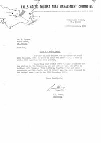
Letter - Site 3 - Request For Extension Until 15th December To Clear Site Granted, 29.11.1961
Bob (Herman) Hymans (a former member of the Royal Netherlands Navy) was born in Bloemendaal, Holland on 30th September 1922. During World War II he fought against the Japanese in the Dutch East Indies (now Indonesia) and was imprisoned in Changi and on the Burma Railway. After gaining qualifications as a Ski Instructor, Bob arrived in Falls Creek in July 1950. Working as an Instructor and Supervisor at Bogong Lodge, Bob decided his future was in accommodation. He was successful in negotiating an indenture for land from the State Electricity Commission (SEC). It took Bob two years to build his Grand Coeur Chalet but, tragically, it was burned down in August 1961. Bob also built the first Chairlift in Australia. This was a single chairlift and the structure was built from wooden electricity poles. He was constantly full of new ideas and proposals for the village. Bob Hymans die on 7th July 2007. This Collection of documents and letters tells the story of Bob's endeavours to develop Falls Creek into the ski village it is today.This letter is significant because it reflects the relationship between Bob Hymans and the Management Committee.A letter from the Management Committee granting an extension to the date for the full cleanup of Site 3 - the location of Bob Hymans' chairlift. All buildings were to be removed and the site returned to its natural condition by 15th December 1961.falls creek tourist area management committee, chairlift licence negotiations, double chairlift -
 Kiewa Valley Historical Society
Photograph of Pretty Valley Workers Camp*, Pretty Valley Camp, circa 1949
Erection of staff quarters at Pretty Valley was completed in April, 1947 and accommodation for construction workers commenced in 1948 but suspended on 11th May for winter and resumed on 9th November. Construction of this camp was completed in 1949. A large dam was proposed at this site but was never constructed. Instead a small diversion dam was built which diverts water either to Rocky Valley Dam or to McKay Creek Power Station.An historical record of the type of accommodation provided for workmen during the construction of the Kiewa Hydro Scheme during the 1940's/50's.A black and white photograph of Pretty Valley Camp, c 1949. Dead trees are in the foreground, on both the left and right side of the photograph and a small snow gum is evident. There are camp huts and a much larger building behind these, possibly a workshop, and power poles are evident bringing electricity to the site.Handwritten in blue ink on back of photograph "Pretty Valley Camp. 5600 ft. above sea level".pretty valley, dam, water, workmen, camp -
 Kiewa Valley Historical Society
Photograph - Folder of Photographs (KVHS 1150 A - F) – Photocopied set of black and white photographs from the display folder (pages 1 - 8) put together by KVHS to document life on the Kiewa Valley Hydro-electric Scheme
Although the Kiewa Hydro-Electric Scheme was first proposed in 1911, construction did not commence until 1938. As part of the push to cut electricity costs and diversify supply, the Victorian Government (circa 1930) initiated the conversion from primarily brown coal supply to hydro – electricity. Field investigations during the 1940’s resulted in a new proposal for a scheme that had more than double the capacity of the 1938 scheme. The Kiewa Hydroelectric Scheme became the largest scheme of its kind in the State Of Victoria and the second largest scheme in Australia. The number of personnel involved in the planning and construction of the scheme increased dramatically. During the late 1940’s, most activity centred around the construction of the West Kiewa Power Station, Rocky Valley Reservoir, McKay Creek Power Station and the Bogong Creek Aqueduct.A common thread across all the larger hydro scheme constructions was the need for workers, both qualified and unqualified who came from around the world seeking a new life for themselves and their families. New accommodation and facilities were required for the army of workers engaged in construction in often remote and wild areas. The SEC had a high demand for timber, and set up the first of a number of sawmills at Bogong Creek in 1939 and set up the first hardwood logging in the headwaters of the Kiewa River. These new ‘towns’ such as Mt Beauty and Bogong, survived, serving the needs of operational personnel and their families, and expanding with growth of new industries. Mount Beauty, and to a lesser extent Bogong, are among these places. Large A3 size spiral bound display folder containing 21 of 58 pages of photocopied black and white photographs of various aspects of the early days of the Kiewa Valley Hydro-electric scheme including equipment, various work sites and photographs of workers and their families. 1-Front page; 2-Security gate at Mt Beauty Camp; 3-Channel 1 on East Kiewa River; 4-Junction Dam – Diversion Tunnel Inlet; 5-Sawmill; 6- Homan’s Gap Sawmill; 7 Junction Dam: 8-Homan Dam Site-Diamond Drilling on River Buttress; 9- Homan Dam Site View Upstream 10-Homan Dam Investigation Camp 1-Windsor & Newton Visual Diary 60 sheet (120 pages) 11’ x 14’ 280 x 356mm 110 GSM Acid Free Drawing Paper 2-1940-Security Gate on Mt Beauty side of Kiewa River bridge. Part of old Mt Beauty camp and mess in background 3- STATE ELECTRICITY COMMISSION OF VICTORIA Date; 11.3.40 Time: 10.30am No K35 Kiewa Hydro Electric Works. Diverting East Kiewa River into Channel Page number 1 4-STATE ELECTRICITY COMMISSION OF VICTORIA Date: 5.4.40 Time: Noon No K58 Kiewa Hydro Electric Works. Junction Dam – Diversion Tunnel Inlet – Normal Flow Page number 2 5- STATE ELECTRICITY COMMISSION OF VICTORIA Date: 19.8.42 Time: 2.30pm No K883 Kiewa Hydro Electric Works. Sawmill – General View Page number 3 6- STATE ELECTRICITY COMMISSION OF VICTORIA Date: 12.1.42 Time: 2.00pm No K540 Kiewa Hydro Electric Works. Homan’s Gap Sawmill – General View Page number 4 7- STATE ELECTRICITY COMMISSION OF VICTORIA Date: 12.1.42 Time: 2.00pm No K540 Kiewa Hydro Electric Works. Junction Dam – General View looking upstream Page number 5 8- STATE ELECTRICITY COMMISSION OF VICTORIA Date: 16.11.45 Time: 10.32amm No K52153 Kiewa Hydro Electric Works Homan Dam Site – Diamond Drilling on River Buttress Page number 6 9-STATE ELECTRICITY COMMISSION OF VICTORIA Date: 15.1.45 Time: 4.10pm No K1781 Kiewa Hydro Electric Works Homan Dam Site – View Upstream Page number 7 10- STATE ELECTRICITY COMMISSION OF VICTORIA Date: 15.1.45 Time: 4.10pm No K1781 Kiewa Hydro Electric Works Homan Dam Investigation Camp 1944 – 1945 Page number 8 secv; kiewa hydro electric scheme; mt beauty; bogong; construction work; -
Glenelg Shire Council Cultural Collection
Photograph - Sheet of 6 contact prints, 1964
Port of Portland Authority ArchivesFront: 20. 5-5-64 22. 5-5-64 21. 5-5-64 24. 5-5-64 23. 5-5-64 (In white, beneath each print). Back: 20 in pencilport of portland archives, k s anderson wharf -
Glenelg Shire Council Cultural Collection
Photograph - Photograph - Silo Construction, c. 1964
Port of Portland Authority ArchivesBack: Blue PHT stamp 19 B 18-12-64 in black inkport of portland archives, silo construction -
Port Melbourne Historical & Preservation Society
Photograph - Cleanup of former COR/BP site, Port Melbourne, Alison Kelly, 1989
Photographed and displayed at Missions to Seamen building in 1989 by Alison KellyDisplay panel with three captioned photos of 1988/89 cleanup of soil on site of former BP tank farm, labelled 'Cleanup in progress at the former BP site in Port Melbourne' Mounted on white board in photocorners, covered in mylarIn ink on back: 'A Kelly 70 Station St Port Melbourne 645 2324'environmental issues, town planning - proposals shelved - bayside, alison kelly -
University of Melbourne, Burnley Campus Archives
Work on paper (item) - Student Work, Iroshan Gangodawialge, Blackney Residence Garden Landscape Design, 2017
It was made as an assessment for HORT90035 Landscape Construction and Graphics, a subject at Burnley Horticultural College coordinated by Andrew Laidlaw. assignment, burnley horticultural college, hort90035 -
 Kew Historical Society Inc
Album, Eva Grant, Historic Buildings in Victoria & New South Wales, 1919-c.1962
One of three scrapbooks created by Eva Grant, a past member of the Kew Historical Society which were donated by her niece, Julie Thomson, in 2013. The scrapbook includes photographs and descriptions of the following sites. (Many of these are now demolished and so the photographs and descriptions may be rare records of a site.) Sites include: Abbotsford (Vic) - Abbotsford Convent, Mayfield (c.1962), prefabricated house - Church street Armadale (Vic) - church (c.1959) - Thomson & Wattletree Roads Arthur’s Seat (Vic) - McCrae homestead Ballarat (Vic) - Memorial plaque on site of Bentley’s Hotel, Memorial on site of Eureka Stockade, Early municipal buildings - East Ballarat, Adam Lindsay Gordon’s cottage - Botanical Gardens, View from Sovereign Hill, Shell house Broken Hill (NSW) - panorama (1963), Flying Doctor’s base (?1963) Eltham (Vic) - Hassell’s outdoor art gallery Essendon (Vic) - Niddrie Homestead and stables (1963) Geelong (Vic) - first Bishopscourt Hawthorn (Vic) - Convent (1930), The Hawthorns, Keilor plains (Vic) - pioneer homes, pioneer cemetery Kew (Vic) - Roseneath (1951), Tarring - Ruyton, Turinville, house - Foley street (c.1960). Malvern (Vic) - church Mount Ridley (Vic) - Summerhill Melbourne (Vic) - Old Brewery - Custom’s House Lane (1960), Customs House, Scott’s Hotel (1962), Western market (c.1960) Phillip Island (Vic) - Grave Toorak (Vic) - Mandeville Hall, Merna (sic) - Arthur Streeton’s house, Toorak House Wentworth (NSW) - Harvey’s Hotel, Sturt Memorial, Sturt’s Tree, Wentworth Gaol Williamstown (Vic) - Williamstown Dairy Yan Yean (Vic) - Bear’s Castle (c.1947) Beveridge/Big Hill (Vic) - Kelly’s cottageImportant photograph record (and notes) about historic buildings in Victoria.38-page scrapbook with additional text created by Eva Grant, a past member of the Kew Historical Society. In addition to the 68 photographs, there are two postcards and a number of publications/handouts.collected by Eva on her trips to heritage sites in Victoria and New South Wales. The pages of the album can be viewed in the image carousel above. Most of the photographs of heritage buildings were taken in the early 1960s.See imagesheritage sites - victoria - australia, eva grant, scrapbooks - 20th century -
 Ringwood and District Historical Society
Photograph, Old well on site of MacRobertson factory, Canterbury Rd Ringwood. 1964
Written on backing sheet, "Old well on site of MacRobertson factory, Canterbury Rd. 1964". -
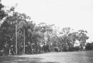 Ringwood and District Historical Society
Photograph, Ringwood Reserve - Northern End. Now Eastland site - 1963
Typed below photograph, "Ringwood Reserve - Northern End. Now Eastland site - 1963" -
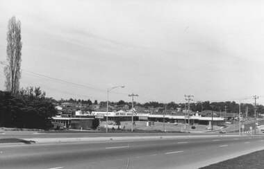 Ringwood and District Historical Society
Photograph, Maroondah Highway East, Ringwood- 1969. Burnt Bridge Shopping Centre, cnr Maroondah Hwy and Beaufort Road
Black and white photographWritten on back of photograph: "Site of Burnt Bridge Hotel - (later a store). Nov 1969." -
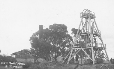 Ringwood and District Historical Society
Photograph, Antimony Mine, Ringwood 1920
Typed below photograph, "Antimony Mine, Ringwood (Now Civic Centre site). 1920". -
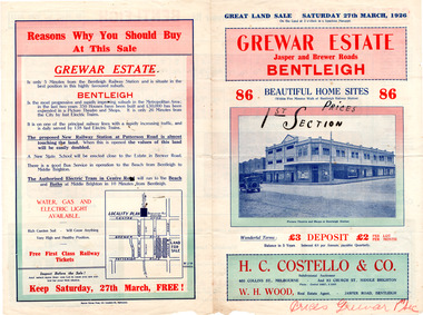 City of Moorabbin Historical Society (Operating the Box Cottage Museum)
Flyer - Grewar Estate, Bentleigh, 1st Section Sold at Auction, 1926
The train line from the city to Frankston was electrified which intensified the sale in the municipality of Moorabbin, particularly land which was in the vicinity of the railway stations.Example of the progress of the Municipality of MoorabbinAdvertising flyer for auction of real estate sales - plan of building blocks for saleGrewar Estate Bentleigh - 86 Home Sites - H.C. Costello & W. H. Woodpatterson road, jasper road, bentleigh, real estate, auction, grewar -
 City of Moorabbin Historical Society (Operating the Box Cottage Museum)
Flyer - Grewar Estate, Bentleigh, 2nd Section Sold at Auction, 1926
The train line from the city to Frankston was electrified which intensified the sale in the municipality of Moorabbin, particularly land which was in the vicinity of the railway stations.Example of the progress of the Municipality of MoorabbinAdvertising flyer for auction of real estate sales - plan of building blocks for saleGrewar Estate Bentleigh - 73 Home Sites - H.C. Costello & W. H. Woodbentleigh, real estate, auction, grewar, mitchell street, daley street, brewer road -
 City of Moorabbin Historical Society (Operating the Box Cottage Museum)
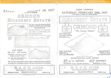
Flyer - Hillcrest Estate, Ormond, 1927
The train line from the city to Frankston was electrified in 1922 which intensified the sale in the municipality of Moorabbin, particularly land which was in the vicinity of the railway stations.Example of the progress of the Municipality of MoorabbinPhotocopy of advertising flyer for auction of real estate sales - plan of building blocks for saleHillcrest Estate, Ormond - 26 Home sites for auction Saturday 26 February 1927.parker street, holloway street, wild cherry road, wallen road, florence street, wimmera street, leila road, real estate, ormond, auction -
Clunes Museum
Book, PINNACLE PRINTING CO. PTY.LTD, VICTORIA 150 YEARS OF GOLD, 2001
VICTORIA 150 YEARS OF GOLD HISTORYGOLD COVERED BOOK - VICTORIA 150 YEARS OF GOLDnon-fictionVICTORIA 150 YEARS OF GOLD HISTORYlocal history, document, book, gold, mining, gold, mining, history -
 Ringwood and District Historical Society
Photograph, Maroondah Highway Central, Ringwood. View of Loughnan's hill taken from Ringwood oval. c1960's
Black and white photographWritten on back of photograph: "Loughnan Hill from Eastland site - 22/6/67". -
 Glenelg Shire Council Cultural Collection
Print - 1988 Calendar - Portland, Victoria, 'Facet of a Silent Site', n.d
Dry point etching. Circular, taupe and black foliage. Trees can be seen in the image, branches, bush and undergrowth. Limed wood frame, single window mount.Front: 'Facet of a Silent Site v/s Herthe Kluge-Pott 2001' - pencilfemale artists, female artist, women -
 Ringwood and District Historical Society
Photograph, Ringwood State School - Rear of Schoolmasters house, Ringwood, 1945
Black and white photograph "Notes attached to photograph" 1945- Rear of Schoolmasters house. Former Nunawading School No 2242. Removed from it's site in Heatherdale on March 18th, 1892 to a site near the corner of Ringwood Street and Civic Place. -
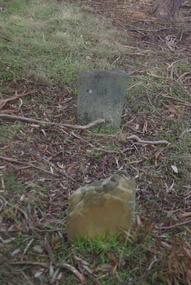
 Ballarat Heritage Services
Photograph - Colour, Grave at Vaughan Chinese Cemetery, 2017, 16/07/2017
This site was used as a burial ground from 1855 (about) to 1859. European and Chinese pioneers rest here. The Bendigo Chinese Society Honouring the memory of their Countrymen, fenced the site, 1928 Population of Vaughan 1859, 13000vaughan, vaughan springs, vaughan chinese cemetery, chinese -
 Ballarat Heritage Services
Photograph - Colour, Grave at Vaughan Chinese Cemetery, 2017, 16/07/2017
This site was used as a burial ground from 1855 (about) to 1859. European and Chinese pioneers rest here. The Bendigo Chinese Society Honouring the memory of their Countrymen, fenced the site, 1928 Population of Vaughan 1859, 13000vaughan, vaughan springs, vaughan chinese cemetery, chinese, thomas eynon -
 Ballarat Heritage Services
Pamphlet - Photograph - Colour, Grave at Vaughan Chinese Cemetery, 2017, 16/07/2017
This site was used as a burial ground from 1855 (about) to 1859. European and Chinese pioneers rest here. The Bendigo Chinese Society Honouring the memory of their Countrymen, fenced the site, 1928 Population of Vaughan 1859, 13000vaughan, vaughan springs, vaughan chinese cemetery, chinese, thomas eynon -
 Ballarat Heritage Services
Photograph - Colour, Grave at Vaughan Chinese Cemetery, 2017, 16/07/2017
This site was used as a burial ground from 1855 (about) to 1859. European and Chinese pioneers rest here. The Bendigo Chinese Society Honouring the memory of their Countrymen, fenced the site, 1928 Population of Vaughan 1859, 13000vaughan, vaughan springs, vaughan chinese cemetery, chinese, thomas eynon -
 Ballarat Heritage Services
Photograph - Colour, House Near Vaughan Chinese Cemetery, 2017, 16/07/2017
This site was used as a burial ground from 1855 (about) to 1859. European and Chinese pioneers rest here. The Bendigo Chinese Society Honouring the memory of their Countrymen, fenced the site, 1928 Population of Vaughan 1859, 13000vaughan, vaughan springs, vaughan chinese cemetery, chinese, thomas eynon -
Bendigo Historical Society Inc.
Map - MAP WHITE HILL TO HUNTLY
Map of Bendigo creek and adjacent leads - White Hills to Huntly replotted from old 4 chain to 1 inch survey of 1860 by G. W. Hart - Surveyor. Base of roads and streets taken from D.L.S. 1 . 10000 base maps. Legend: battery site, puddling mill site, dam bank site, cutting altering course of creek, lead boundaries.bendigo, mining -
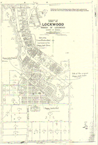 Bendigo Historical Society Inc.
Map - LONG GULLY HISTORY GROUP COLLECTION: LOCKWOOD TOWNSHIP
Copy of a map of Township of Lockwood, County of Bendigo. Printed at the top of the map is: Parish map of Lockwood showing location of Happy Jack's paddock & hut and the sites of the Crown & Anchor Hotel and the original Happy Jack Hotel. Written on the map with arrows pointing to the site is: Happy Jack's Paddock, Site of the original Happy Jack Hotel and Happy Jack's Hut. An outline of Happy Jack's Paddock is drawn in.bendigo, history, long gully history group, the long gully history group - lockwood township, crown & anchor hotel, happy jack hotel, happy jack store, county of bendigo -
 Marysville & District Historical Society
Photograph (Item) - Colour photograph, Travel Victoria, 2006
A colour photograph taken in Murchison Street in Marysville in Victoria.A colour photograph taken in Murchison Street in Marysville in Victoria.marysville, murchison street, victoria, photograph