Showing 3847 items
matching surveyed
-
 Whitehorse Historical Society Inc.
Map, Melbourne Metropolitan Area Base Map series. Sheet 214, c1960
Map showing northern section of the City of Nunawading together with parts of Shire of Doncaster and Templestowe.Map showing northern section of the City of Nunawading together with parts of Shire of Doncaster and Templestowe. Shows roads, creeks, block numbers and contours at 5 feet vertical increments. Note on map: 'prepared ... from State Aerial Survey, January 1957 and Cadastral Survey information February 1959'.Map showing northern section of the City of Nunawading together with parts of Shire of Doncaster and Templestowe. maps, city of nunawading, shire of doncaster and templestowe -
 Bendigo Historical Society Inc.
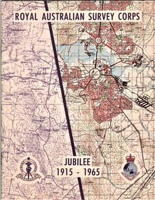
Document - AULSEBROOK COLLECTION: ROYAL AUSTRALIAN SURVEY CORPS JUBILEE 1965, 1965
Aulsebrook Collection: two pamphlets relating to a Jubilee events at the Royal Australian Survey Corps. Title: Royal Australian Survey Corps, Jubilee 1915-1965 (x 2 pamphlets) Two pamphlets for same event, A5, colourful map on the front of the booklet, -First pamphlet is a dinner and wine menu for Jubilee event -Second pamphlet is a information booklet on a brief history of the Corps, and a list of ranks and individuals in the Survey Corps. Booklet also has some photos of Fortuna where the Corps is. -
Bendigo Historical Society Inc.
Map - YALLOOK : COUNTY OF BENDIGO, 1957
Map. Yallook, County of Bendigo, Talambe, Neilborough, Yarraberb, Salisbury, Pompapiel. Drawn and reproduced at the Department of Lands and Survey, Melbourne,1957. Distances shown on the plan are derived from original surveys of varying dates and whilst approximately correct do not necessarily conform to modern standards of accuracy. For survey information application should be made to the central plan office, or to the office of titles. Some ink scibbles appear at the right top of this map. Price 2/-. (number 14 in map cupboard 1)By Authority W.M.Houston, Govt.Printer,Melbourne.map, bendigo, yallook -
Kew Historical Society Inc
Archive (Sub-series) - Subject File, Barnard Grove (Kew), 1985
Dorothy Benyei & Rosemary SmartReference, Research, InformationKHS OrderSubject file containing responses to a survey of residents of Barnard Grove, Kew (Vic), issued in 1985. The questionnaire requested information about when the respondee/s moved into the street, whether alterations had been made to their house, the reason why they moved to Barnard Grove, its good points and its limitations, and further comments. Rosemary Smart and Dorothy Benyei conducted the survey on behalf of the Society. The file contains many interesting responses from those who returned the surveys.barnard grove - kew east (vic.)barnard grove - kew east (vic.) -
 Bendigo Historical Society Inc.
Document - LANDS OFFICE - CROWN LANDS SURVEYED AND SOLD SANDHURST, 1860 onwards
Journal: LANDS OFFICE - CROWN LANDS SURVEYED AND SOLD SANDHURST green hard cover journal with buff spine and corners. Contains details of crown land surveyed and sold in the district of Sandhurst. Indexed in front by parish, alphabetical double pages not numbered. On LH page, parish, town, suburban, country, date of survey. On RH page, date of sale, auction, selection, price, total amount, purchaser. On spine ' index book' 'F' and '09'. Dated from 1860 onwardsLands Officeland sales, bendigo -
 Bendigo Military Museum
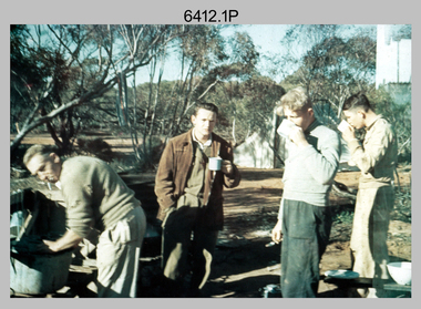
Photograph - Royal Australian Survey Corps Surveyors in the Field – Victoria, 1956 - 1958
This is a set of two photographs of surveyors and support staff in the field undertaking tasks in Victoria 1956 – 1958. The surveyors were employed in the establishment of mapping and geodetic control. In this era surveyors used theodolites to observe horizontal and vertical angles and chains to measure base line distances between survey stations. This is a set of 23 photographs of surveyors and support staff in the field undertaking duties in Victoria 1956 – 1958. The photographs were printed on photographic paper and are part of the Army Survey Regiment’s Collection. The photographs were scanned at 300 dpi. .1) - Photo, colour, 1956. Surveyors enjoying a tea break. L to R: Tom Gilbert (cook), Barry Broad, Tony Slattery, John Van De Graff. Taken at Boonoonar, a locality south of Mildura. .2) - Photo, colour, 1958. Surveyors taking a break from driving. L to R: Leo Bub, Bob Thompson. Taken at Puckapunyal..1P to .2P annotated on back – personnel names, the year and the location. royal australian survey corps, rasvy, army survey regiment, asr, army svy regt, fortuna, surveying -
 Bendigo Military Museum
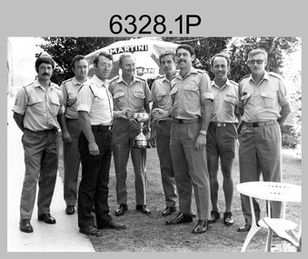
Photograph - Army Survey Regiment’s Rifle Shooting Team, Fortuna, Bendigo, c1979
This set of 10 photographs of the Army Survey Regiment’s victorious rifle shooting team was taken outside the Tavern at Fortuna, Bendigo in c1979. The rifle shooting competition was the ‘Irwin Trophy for Shooting’, a contest with the British Army’s 42nd Engineer Regiment, the equivalent military geographic mapping unit at the time to the Army Survey Regiment. The bent .303 rifle seen in photo .3P was retrieved from the bottom of Fortuna’s lake when it was drained for restoration. It is believed an excavator drove over the rifle before it was retrieved.This set of 10 photographs of the Army Survey Regiment’s rifle shooting team was taken at Fortuna, Bendigo in c1979. The photographs were printed on photographic paper and are part of the Army Survey Regiment’s Collection. The 35mm positive photographic proofs were scanned at 600 dpi. Larger prints of .1P, .3P and .10P were scanned at 300 dpi. .1) & 2) - Photo, black & white, c1979, Rifle Shooting Team - L to R: Warren ‘Waldo’ Shirley, John Waight, Peter Searle UK Exchange, CO LTCOL Bob Skitch, Jim Macdonald, John Harrison, Max Neil, Stan Vote. .3) - Photo, black & white, c1979, Rifle Shooting Team - L to R: Stan Vote, John Harrison, Max Neil, Warren ‘Waldo’ Shirley, Jim Macdonald, John Waight. .4) - Photo, black & white, c1979, Rifle Shooting Team - L to R: CO LTCOL Bob Skitch, Jim Macdonald, Stan Vote. .5) - Photo, black & white, c1979, Rifle Shooting Team - L to R: John Waight, Warren ‘Waldo’ Shirley. .6) - Photo, black & white, c1979, Rifle Shooting Team - L to R: Warren ‘Waldo’ Shirley, CO LTCOL Bob Skitch. .7) - Photo, black & white, c1979, Rifle Shooting Team - L to R: CO LTCOL Bob Skitch, Warren ‘Waldo’ Shirley, Stan Vote, Jim Macdonald, Max Neil. .8) - Photo, black & white, c1979, Rifle Shooting Team - L to R: Jim Macdonald, Max Neil, Stan Vote. .9) - Photo, black & white, c1979, Rifle Shooting Team - L to R: CO LTCOL Bob Skitch, Peter Searle UK Exchange, Warren ‘Waldo’ Shirley. .10) - Photo, black & white, c1979, Irwin Trophy for Shooting..1P to .10P –No personnel are identified.royal australian survey corps, rasvy, army survey regiment, army svy regt, fortuna, asr -
 Bendigo Historical Society Inc.
Map - GREAT EXTENDED HUSTLER'S MINE - PLAN OF THE GREAT EXTENDED HUSTLER'S MINE
Plan of the Great Extended Hustler's Mine. Bulletin No 33, Plate No XI. Shows No 2 Shaft, Latham & Watson's Shaft, levels and their depths and some geographical features. Geographical Survey of Victoria emblem and signed by H A Whitelaw, Underground Survey Office, Bendigo, September 1913. Has reference to photos.mining, parish map, great extended hustler's mine, no 2 shaft, latham & watson's shaft, geological survey of victoria, underground survey office bendigo, h a whitelaw -
Bendigo Historical Society Inc.
Map - UNITED HUSTLER'S & REDAN MINE - TRANSVERSE SECTIONS N & S OF SHAFT UNITED HUSTLER'S & REDAN MINE
Transverse Sections N & S of Shaft United Hustler's & Redan Mine on the Hustler's Line of Reef Bulletin No 33, Plate No XXX. Map shows some of the stone encountered on the levels and depth. Geological Survey of Victoria emblem and signed by H A Whitdan, Underground Survey Office Bendigo, September 1913.mining, parish map, united hustler's & redan mine, transverse sections n & s of shaft united hustler's & redan mine, hustler's line of reef -
 Bendigo Historical Society Inc.
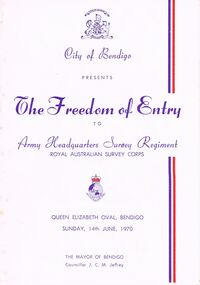
Document - LYDIA CHANCELLOR COLLECTION; THE FREEDOM OF ENTRY PROGRAMME
A white programme with red and purple print. The front cover contains the words ' City of Bendigo Presents The Freedom of Entry to Army Headquarters Survey Regiment Royal Australian Survey Corps. Queen Elizabeth Oval, Bendigo Sunday, 14th June, 1970. The Mayor of Bendigo Councillor J.C. M. Jeffrey.'program, music, royal australian survey corps, lydia chancellor, collection, program, programme, the freedom of entry, royal australian survey corps., event, entertainment, music, ephemera -
 The Beechworth Burke Museum
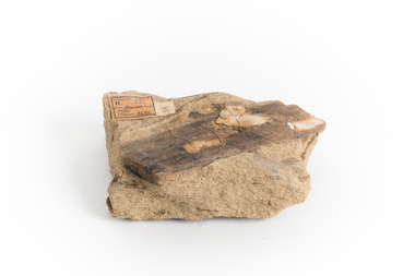
Geological specimen - Yellow Sandstone
This specimen is from Barefoot Hills, Victoria. Sandstones are economically important as major reservoirs for both petroleum and water, as building materials, and as valuable sources of metallic ores. Most significantly, they are the single most useful sedimentary rock type for deciphering Earth history. This specimen is part of a larger collection of geological and mineral specimens collected from around Australia (and some parts of the world) and donated to the Burke Museum between 1868-1880. A large percentage of these specimens were collected in Victoria as part of the Geological Survey of Victoria that begun in 1852 (in response to the Gold Rush) to study and map the geology of Victoria. Collecting geological specimens was an important part of mapping and understanding the scientific makeup of the earth. Many of these specimens were sent to research and collecting organisations across Australia, including the Burke Museum, to educate and encourage further study.A sedimentary rock composed mostly of quartz sand. Sandstone is the second most common sedimentary rock after shale. Sandstones consist of sand-sized grains principally quartz, feldspar and rock fragments. The two major classes of sandstone are arenite and wacke. the colour of sandstone varies from grey, yellow, red and white reflecting the variation in mineral content and cement and is gritty to touch (like sandpaper).Geological survey / R.... S 61 / Loc Bareboot Hills / Sheet / 24SE / 94 /burke museum, beechworth, indigo shire, beechworth museum, geological, geological specimen, mineralogy, sandstone, yellow sandstone, victoria, barefoot hills -
 Bendigo Historical Society Inc.
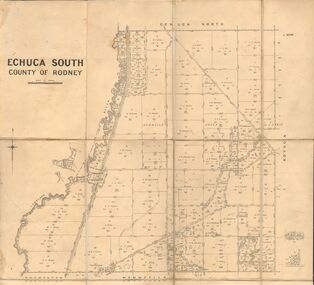
Map - JACK FLYNN COLLECTION: ECHUCA SOUTH, 13/08/1931
Map: Parish of Echuca South, County of Rodney. Parish plan.By Authority H. J. Green, Govt. Printer. Department of Lands and Survey, Melbourne. 13.8.31map, rodney, parish plan, echuca south , county of rodney -
 Bendigo Historical Society Inc.
Map - JACK FLYNN COLLECTION: KARA KARA, 1932
Map: County of Kara Kara, map sheet showing the whole of the County of Kara Kara and all of the Parishes within. Scale 2 miles to 1 inch.By Authority: W.M. Houston, Government Printer Melbourne. Department of Lands and Survey, Melbourne, 1958map, kara kara, county, kara kara -
 Bendigo Historical Society Inc.
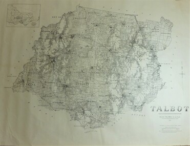
Map - JACK FLYNN COLLECTION: TALBOT, 1937
Map: County of Talbot, map sheet showing the whole of the County of Talbot and all of the Parishes within. Scale 2 Miles to 1 inch.By Authority: A.C. Brooks, Government Printer, Melbourne. Department of Lands and Survey Melbourne. 1959map, talbot, county, talbot -
 Bendigo Historical Society Inc.
Map - JACK FLYNN COLLECTION: COUNTY OF GLADSTONE, 1934
Map: County of Gladstone, map sheet showing the whole of the County and the Parishes within. Scale 2 Miles to 1 inch.Engraved at the Department of Lands and Survey Melbourne. 1958. By Authority of W.M. Houston, Government Printermap, gladstone, parish plan, gladstone -
Stawell Historical Society Inc
Map, Department of Crown Lands and Survey Victoria, Allotments in the Township of Banyana. Parish of Burrum Burrum. 1946 / 1971, 1971
Richardson River. Avon River JunctionPaper Map of County of BorungReprint of the 1946 edition. Drawn and reproduced at the Department of Crown Lands and Survey Victoria 1971.survey -
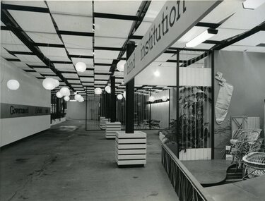 Vision Australia
Photograph - Image, Queensland Blind Institution display at exhibition, 1962?
Part of a display by the Queensland Blind Institution (?) as part of a exhibition. Neither the full name of the organisation nor the exhibition are known, however a sign on the opposite wall reads "Government Exhibit 1962". Cane chairs, an ironing board cover, coat hangers, a cane cot and a cane screen are viewable to the far right of the image. The remaining view is of an empty space awaiting exhibitors.1 x B/W photograph of exhibition spaceC2-4138 Reproduced by Photo Section, Survey Office, Dept. Public Lands, QLD.queensland industrial institute for the blind, fundraising -
 Flagstaff Hill Maritime Museum and Village
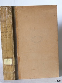
Book, Manual of the New Zealand Coleoptera
Manual of the New Zealand Coleoptera Author: CaptainThomas Broun Publisher: Colonial Museum and Geological Survey dept Date: 1880Label on spine with typed text RH 595.76 BRO Inside front cover has a sticker that reads Warrnambool Mechanics Institute and Free Library warrnambool, shipwrecked-coast, flagstaff-hill, flagstaff-hill-maritime-museum, maritime-museum, shipwreck-coast, flagstaff-hill-maritime-village, shipwrecked-artefact, book, manual of the new zealand coleoptera -
 Federation University Historical Collection
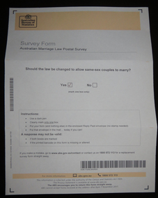
Document, Australian Marriage Law Survey, 2017, 12/09/2017
The vote was made online, so the paper vote papers were kept and donated. Letter from Australian Statistician David W. Kalisch regarding the Australian Marriage Survey, and a photograph of the ballot paper and envelope.australian marriage law, marriage equality, australian bureau of statistics, gay marriage, same sex marriage -
 Bendigo Historical Society Inc.
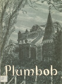
Book - PLUMBOB, 1968
Plumbob. The unit magazine of AHQ Survey Regiment Bendigo, which was located at Fortuna. Vol 1 No 2 Dec 1968bendigo, history, fortuna and survey reg. -
 Bendigo Historical Society Inc.
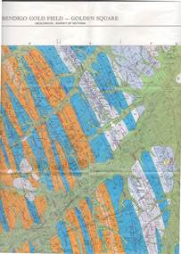
Map - STRUGNELL COLLECTION: GEOLOGICAL SURVEY OF VICTORIA, BENDIGO GOLD FIELD - GOLDEN SQUARE, 1992
Map, Geological Survey of Victoria, Bendigo Gold Field - Golden Square, Campaspe 10 000/2.2. Victoria 10,000.Dept. 0f Manufacturinf & Industry Development.map, bendigo, golden square gold field -
 Bendigo Historical Society Inc.
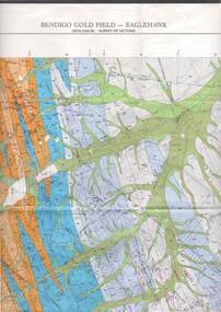
Map - STRUGNELL COLLECTION: GEOLOGICAL SURVEY OF VICTORIA, BENDIGO GOLD FIELD - EAGLEHAWK, 1992
Map, Geological Survey of Victoria, Bendigo Gold Field - Eaglehawk.Campaspe10 000/2.3; Victoria 1:10,000. Index of Shafts.Dept. of Manufacturing & Industry Developmentmap, bendigo, eaglehawk gold field -
Port Melbourne Historical & Preservation Society
Letter - Lands & Survey Office re permission to use land for football ground, 13 May 1880
Letter from Lands & Survey Office granting permission for use of land as per tracing sheet for football ground, 1880sport - australian rules football, sport - recreational grounds, peter gallienne grut, port melbourne football club, pmfc -
Port Melbourne Historical & Preservation Society
Document - Reports, Planning, development and traffic management, Loder & Bayly, 1974 - 1978
12 surveys re planning, development and traffic management carried out by Loder & Bayly, August 1974 to February 1978local government - city of port melbourne, town planning, transport - roads, built environment - commercial, built environment - zoning, loder & bayly, glen cosham -
Bendigo Historical Society Inc.
Map - WESTON, 21/10/1876
Map: Re-Survey of part of the parish of Weston, County of Rodney. Parish plan (number 309 in map cupboard 1)Murray and Hargreave, Authorised surveyorsmap, rodney, parish plan, parish of weston, murray and hargreave -
 Bendigo Historical Society Inc.
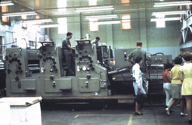
Slide - AHQ,SURVEY REGT, FORTUNA,BENDIGO, April 1970
Slide. AHQ, Survey Regt, Fortuna, Bendigo. Three Regiment workers operating the mapping machines while visitors are looking on.slide, bendigo, ahq, survey regt, fortuna, bendigo., ahq, survey regt, fortuna, bendigo. -
Clunes Museum
Map
Photocopy of map Underground Survey of mines at Clunes Clunes Goldfields Co. (two sheets joined) Port Phillip Co.Nilcartography, clunes mines, clunes goldfield co. -
Whitehorse Historical Society Inc.
Document, Annual Report, 1968
Annual Report of the Place Names Committee of Victoria for the year ended 30 June 1968. Department of Crown Lands and Survey.Annual Report of the Place Names Committee of Victoria for the year ended 30 June 1968. Department of Crown Lands and Survey.Annual Report of the Place Names Committee of Victoria for the year ended 30 June 1968. Department of Crown Lands and Survey.crown lands, victorian government, victoria. place names committee -
Whitehorse Historical Society Inc.
Document, Heritage survey, 1/10/1994 12:00:00 AM
City of Nunawading Heritage Survey Project [Description]. Context Pty Ltd [Consultants] October 1994.City of Nunawading Heritage Survey Project [Description]. Context Pty Ltd [Consultants] October 1994. (Original and 2 photocopies)City of Nunawading Heritage Survey Project [Description]. Context Pty Ltd [Consultants] October 1994. city of nunawading, historic buildings, context pty ltd -
Bendigo Historical Society Inc.
Document - Golden City Implements Foundry, Ironbark, Bendigo, 1960-1980s
This foundry had been a landmark in Mt Korong Road for many years. It began with an Osborne and Mitchell. After 1914 when mining declined, it became the Golden City Implement boundary and the name can still be seen painted on on the façade which faces the intersection of Marong Road (Calder highway) and Eaglehawk Road. The interior is a mass of used and un-used machinery scattered amongst modern lathes and more modern apparatus. The yard was a fascinating graveyard of past times, with old mining and agricultural scrap everywhere mixed up with coke and slag from the smelting sheds at the rear. A feature of the foundry was the manufacturer of cast iron lace. National Trust Survey Data Sheet and article from the Bendigo Advertiser November 4th 1981. Osbornes Ironbark Foundryhistory, national trust bendigo collection, bendigo, foundary, iron bark bendigo