Showing 848 items
matching surveyors
-
 Falls Creek Historical Society
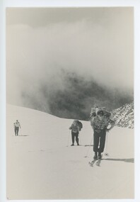
Photograph - Bogong Trip 1951- On Eskdale Spur
MEYER COLLECTION - FALLS CREEK PHOTOS In 1947 a determined group of like-minded State Electricity Commission (SEC) staff including Ray Meyer, the chief surveyor of the Kiewa Hydro-Electric Scheme, had a common interest that revolved around the skiing potential of the snow-covered high plains which included what is now the resort of Falls Creek. The six SEC employees, Toni St Elmo, Ray Meyer, Jack Minogue, Lloyd Dunn, Adrian Ruffenacht and Dave Gibson (together with their families) banded together to secretly build a 'hut' that was the first ski lodge at Falls Creek. Using a road built in 1930s to gain access to Falls Creek, their hut project was carried out in secret as efforts by other skiers were blocked by H.H.C. Williams – the engineer in charge of the Hydro Scheme. In 1946 Ray Meyer made a trip to the Lands Office in Melbourne. He came away with a 99-year lease on three acres that was ideally suited for a hut designed by Lloyd Dunn. Adrian Ruffenacht (Design Engineer for the KHS) had suggested where the group should build because of easy access to a spring for water. Much of the building material required was scavenged from derelict huts on the high plains. Due to the need for secrecy, the determined group worked on the hut in the evenings and weekends to avoid detection. During the building period the group had met at Echidna Rock (now known as Eagle Rock) where Skippy St Elmo announced, "This is my favourite ‘Skyline’.” And so the first lodge in the area at Falls Creek Ski Resort came into existence. With the development of the International Poma in the 1970s, the Skyline Lodge, which was sited between the ski-lift’s pole one and pole two, was demolished. However, the legacy of Ray Meyer, Toni St Elmo, Jack Minogue, Lloyd Dunn, Adrian Ruffenacht and Dave Gibson and Skyline lives on in the vibrant atmosphere of Falls Creek Resort. The MEYER COLLECTION documents developments on the Kiewa Hydro Scheme and their life at Falls Creek from the mid 1930s to 1960s.This image is significant because it depicts aspects of the life of a pioneering family of Falls Creek and the founders of "Skyline", the first lodge at Falls Creek.Black and White Image of Skiers on Eskdale Spur Left to Right:- Wal Johnson, R. Gibbs, Raye Meyerfalls creek, bogong high plains, ray meyer, timms spur -
 Falls Creek Historical Society
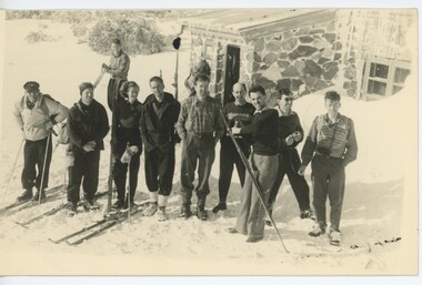
Photograph - Bogong Trip 1951- Outside Cleve Cole Hut
MEYER COLLECTION - FALLS CREEK PHOTOS In 1947 a determined group of like-minded State Electricity Commission (SEC) staff including Ray Meyer, the chief surveyor of the Kiewa Hydro-Electric Scheme, had a common interest that revolved around the skiing potential of the snow-covered high plains which included what is now the resort of Falls Creek. The six SEC employees, Toni St Elmo, Ray Meyer, Jack Minogue, Lloyd Dunn, Adrian Ruffenacht and Dave Gibson (together with their families) banded together to secretly build a 'hut' that was the first ski lodge at Falls Creek. Using a road built in 1930s to gain access to Falls Creek, their hut project was carried out in secret as efforts by other skiers were blocked by H.H.C. Williams – the engineer in charge of the Hydro Scheme. In 1946 Ray Meyer made a trip to the Lands Office in Melbourne. He came away with a 99-year lease on three acres that was ideally suited for a hut designed by Lloyd Dunn. Adrian Ruffenacht (Design Engineer for the KHS) had suggested where the group should build because of easy access to a spring for water. Much of the building material required was scavenged from derelict huts on the high plains. Due to the need for secrecy, the determined group worked on the hut in the evenings and weekends to avoid detection. During the building period the group had met at Echidna Rock (now known as Eagle Rock) where Skippy St Elmo announced, "This is my favourite ‘Skyline’.” And so the first lodge in the area at Falls Creek Ski Resort came into existence. With the development of the International Poma in the 1970s, the Skyline Lodge, which was sited between the ski-lift’s pole one and pole two, was demolished. However, the legacy of Ray Meyer, Toni St Elmo, Jack Minogue, Lloyd Dunn, Adrian Ruffenacht and Dave Gibson and Skyline lives on in the vibrant atmosphere of Falls Creek Resort. The MEYER COLLECTION documents developments on the Kiewa Hydro Scheme and their life at Falls Creek from the mid 1930s to 1960s.This image is significant because it depicts aspects of the life of a pioneering family of Falls Creek and the founders of "Skyline", the first lodge at Falls Creek.Black and White Images taken at Cleve Cole Hut Photo 1 Outside Cleve Cole 1951 - From Left: Ray Meyer, Wal Johnson and other people from a visiting group Photo 2 Cleve Cole Hut Mt. Bogong CLEVE COLE HUT was built in 1937 for the Ski Club of Victoria, to commemorate pioneer skier, Cleve Cole, who died on a disastrous ski trip across the high In August 1936 three men, Cleve Cole, Mick Hull, and Howard Michell, skied from Mount Hotham across the Bogong High Plains to Mount. On reaching the mountain they became trapped for four days on the summit ridge by appalling weather conditions. For three days they followed the Big River through rough country before deciding that Howard should continue alone to find help, leaving Mick to care for Cleve who was barely able to continue. Three days later a search party, raised after Howard had reached Glen Valley, found Cleve and Mick. Within two days the group arrived at Glen Valley where, tragically, Cleve Cole died later that night. In memory of Cleve’s life and his pioneering work in the Victorian alpine country it was decided to build a refuge hut on the mountain. It is called the Cleve Cole Memorial Hut.falls creek, bogong high plains, ray meyer, cleve cole hut -
 Falls Creek Historical Society
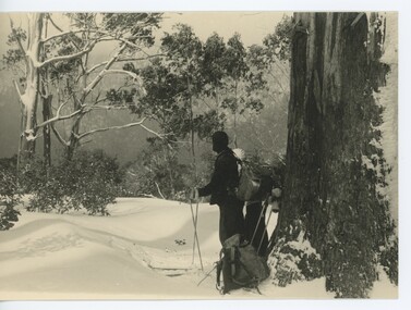
Photograph - Bogong Trip 1951- Wal Johnson on Timms Spur
MEYER COLLECTION - FALLS CREEK PHOTOS In 1947 a determined group of like-minded State Electricity Commission (SEC) staff including Ray Meyer, the chief surveyor of the Kiewa Hydro-Electric Scheme, had a common interest that revolved around the skiing potential of the snow-covered high plains which included what is now the resort of Falls Creek. The six SEC employees, Toni St Elmo, Ray Meyer, Jack Minogue, Lloyd Dunn, Adrian Ruffenacht and Dave Gibson (together with their families) banded together to secretly build a 'hut' that was the first ski lodge at Falls Creek. Using a road built in 1930s to gain access to Falls Creek, their hut project was carried out in secret as efforts by other skiers were blocked by H.H.C. Williams – the engineer in charge of the Hydro Scheme. In 1946 Ray Meyer made a trip to the Lands Office in Melbourne. He came away with a 99-year lease on three acres that was ideally suited for a hut designed by Lloyd Dunn. Adrian Ruffenacht (Design Engineer for the KHS) had suggested where the group should build because of easy access to a spring for water. Much of the building material required was scavenged from derelict huts on the high plains. Due to the need for secrecy, the determined group worked on the hut in the evenings and weekends to avoid detection. During the building period the group had met at Echidna Rock (now known as Eagle Rock) where Skippy St Elmo announced, "This is my favourite ‘Skyline’.” And so the first lodge in the area at Falls Creek Ski Resort came into existence. With the development of the International Poma in the 1970s, the Skyline Lodge, which was sited between the ski-lift’s pole one and pole two, was demolished. However, the legacy of Ray Meyer, Toni St Elmo, Jack Minogue, Lloyd Dunn, Adrian Ruffenacht and Dave Gibson and Skyline lives on in the vibrant atmosphere of Falls Creek Resort. The MEYER COLLECTION documents developments on the Kiewa Hydro Scheme and their life at Falls Creek from the mid 1930s to 1960s.This image is significant because it depicts aspects of the life of a pioneering family of Falls Creek and the founders of "Skyline", the first lodge at Falls Creek.Black and White Image of Wal Johnson near a stand of trees on Timms Spurfalls creek, bogong high plains, timms spur, wal johnson -
 Falls Creek Historical Society
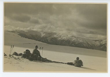
Photograph - Bogong Trip 1951- Mt. Bogong from above Roper's Hut
MEYER COLLECTION - FALLS CREEK PHOTOS In 1947 a determined group of like-minded State Electricity Commission (SEC) staff including Ray Meyer, the chief surveyor of the Kiewa Hydro-Electric Scheme, had a common interest that revolved around the skiing potential of the snow-covered high plains which included what is now the resort of Falls Creek. The six SEC employees, Toni St Elmo, Ray Meyer, Jack Minogue, Lloyd Dunn, Adrian Ruffenacht and Dave Gibson (together with their families) banded together to secretly build a 'hut' that was the first ski lodge at Falls Creek. Using a road built in 1930s to gain access to Falls Creek, their hut project was carried out in secret as efforts by other skiers were blocked by H.H.C. Williams – the engineer in charge of the Hydro Scheme. In 1946 Ray Meyer made a trip to the Lands Office in Melbourne. He came away with a 99-year lease on three acres that was ideally suited for a hut designed by Lloyd Dunn. Adrian Ruffenacht (Design Engineer for the KHS) had suggested where the group should build because of easy access to a spring for water. Much of the building material required was scavenged from derelict huts on the high plains. Due to the need for secrecy, the determined group worked on the hut in the evenings and weekends to avoid detection. During the building period the group had met at Echidna Rock (now known as Eagle Rock) where Skippy St Elmo announced, "This is my favourite ‘Skyline’.” And so the first lodge in the area at Falls Creek Ski Resort came into existence. With the development of the International Poma in the 1970s, the Skyline Lodge, which was sited between the ski-lift’s pole one and pole two, was demolished. However, the legacy of Ray Meyer, Toni St Elmo, Jack Minogue, Lloyd Dunn, Adrian Ruffenacht and Dave Gibson and Skyline lives on in the vibrant atmosphere of Falls Creek Resort. The MEYER COLLECTION documents developments on the Kiewa Hydro Scheme and their life at Falls Creek from the mid 1930s to 1960s.This image is significant because it depicts aspects of the life of a pioneering family of Falls Creek and the founders of "Skyline", the first lodge at Falls Creek.Black and White Image of Mt. Bogong from above Roper's Hut with Wal Johnson and Ray Meyer seated on the ground. ROPER'S HUT Frederick Roper and his family grazed the Bogong High Plains from the 1890s until 1908. Frederick "Jack" built three huts. The hut known as Roper’s Hut was built on Jack's new grazing lease after his former run had been acquired by the SEC in the late 1930s. It had become a well-used refuge hut prior to its destruction in the 2003 bushfires. It was rebuilt by Victorian High Country Huts Association in 2008.falls creek, bogong high plains, wal johnson, ray meyer, ropers hut -
 Falls Creek Historical Society
Clothing - Wool Shirt, Camp at Gap Saddle
MEYER COLLECTION - FALLS CREEK PHOTOS In 1947 a determined group of like-minded State Electricity Commission (SEC) staff including Ray Meyer, the chief surveyor of the Kiewa Hydro-Electric Scheme, had a common interest that revolved around the skiing potential of the snow-covered high plains which included what is now the resort of Falls Creek. The six SEC employees, Toni St Elmo, Ray Meyer, Jack Minogue, Lloyd Dunn, Adrian Ruffenacht and Dave Gibson (together with their families) banded together to secretly build a 'hut' that was the first ski lodge at Falls Creek. Using a road built in 1930s to gain access to Falls Creek, their hut project was carried out in secret as efforts by other skiers were blocked by H.H.C. Williams – the engineer in charge of the Hydro Scheme. In 1946 Ray Meyer made a trip to the Lands Office in Melbourne. He came away with a 99-year lease on three acres that was ideally suited for a hut designed by Lloyd Dunn. Adrian Ruffenacht (Design Engineer for the KHS) had suggested where the group should build because of easy access to a spring for water. Much of the building material required was scavenged from derelict huts on the high plains. Due to the need for secrecy, the determined group worked on the hut in the evenings and weekends to avoid detection. During the building period the group had met at Echidna Rock (now known as Eagle Rock) where Skippy St Elmo announced, "This is my favourite ‘Skyline’.” And so the first lodge in the area at Falls Creek Ski Resort came into existence. With the development of the International Poma in the 1970s, the Skyline Lodge, which was sited between the ski-lift’s pole one and pole two, was demolished. However, the legacy of Ray Meyer, Toni St Elmo, Jack Minogue, Lloyd Dunn, Adrian Ruffenacht and Dave Gibson and Skyline lives on in the vibrant atmosphere of Falls Creek Resort. The MEYER COLLECTION documents developments on the Kiewa Hydro Scheme and their life at Falls Creek from the mid 1930s to 1960s.These images are significant because they depict aspects of the life of a pioneering family of Falls Creek and the founders of "Skyline", the first lodge at Falls Creek.A blue and brown checked shirt made of woollen fabric. It has a buttoned down collar and front closing. Meyer Family records suggest that it could have been handmade by Rel Gibbs who hand made woollen shirts and embroidering Skyline badges.falls creek, building skyline, skyline founders, toni st elmo, adrian ruffenacht, jack minogue, ray meyer, lloyd dunn, david gibson -
 Bendigo Military Museum
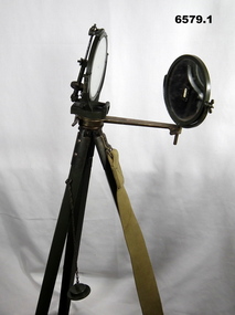
Instrument - Duplex Heliograph Mk V - 1940 with Tripod, LUCO Art Metal Coy Ltd, London, 1940
The Heliograph MkV is a fascinating piece of historical surveying and communications equipment. It was primarily used for visual signaling by reflecting sunlight with a mirror to send coded messages over long distances. This method was primarily useful in remote areas where other forms of communication were not available. The MkV model, specifically, was widely used by the British Army and other military forces from around 1906 until the mid 1960s. It remained in use with the Australian Army Survey Corps until the mid 1980s. The device typically included a 5 - inch mirror and was often mounted on a tripod for stability. Initially the instrument was used to communicate between survey stations using Morse code to coordinate their activities. Later when better forms of communication were available, they were used for precise angle alignment where the sunlight reflection from the mirror was targeted between the survey stations to give very accurate results. The MkV was relatively light weight and portable, making it ideal for use in the field. It could be setup and adjusted quickly. The heliograph had an adjustable mirror that could be tilted to reflect sunlight towards a distant receiver. Surveyors could align the mirror using a sighting device. Whilst it was primarily used by the Military it was also used in civil surveying particularly in the remote areas of Australia. The British Army Mark V version uses a flat round mirror with a small unsilvered spot in the centre. The sender aligned the heliograph to the target by looking at the reflected target in the mirror and moving their head until the target was hidden by the unsilvered spot. Keeping their head still, they then adjusted the aiming rod so its cross wires bisected the target, they then turned up the sighting vane, which covered the cross wires with a diagram of a cross, and aligned the mirror with the tangent and elevation screws, so the small shadow that was a reflection of the unsilvered spot hole was on the cross target. This indicated that the sunbeam was pointing at the target. If the sun was in front of the sender, its rays were reflected directly from this mirror to the receiving station. If the sun was behind the sender, the sighting rod was replaced by a second mirror, to capture the sunlight and direct it onto the main mirror to reflect it to the receiving station.. 1 Brish Army "Mance" Mk V A253 Heliograph has two 125mm diameter mirrors on a brass arm with targeting attachments. The Instrument is mounted on a three-legged tripod of brass and mahogany with spiked feet, approximately 1.2 metres high. The instrument was made by LUCO Art Metal Co Ltd, London in 1940. .2 A military green metal carrying safety storage case with khaki shoulder strap.A253 stamped on instrumentroyal australian survey corps, rasvy, fortuna, army survey regiment, army svy regt, asr -
 Melton City Libraries
Map, Streets of Melton, 1963
MELTON’S STREETS Heritage Week 2014 What’s in a Name? Alphabetical List Aboriginal place names, Early Family Names and landowners, Agricultural, Shop and Commercial premises, Places and Events Melton & District Historical Society Street Naming Project 1972 – c 1998 Suburb Name – KURUNJANG - Kirkton, 1972, Brookfield, West, 1988 Melton and Town Centre - A joint collaboration with the Shire of Melton and Subdivision Developers ARNOLD Court – Family house - Arnolds Creek ALKEMADE Drive Family – Lime kilns Coimadia ALEXANDRA Street 1902 – Corination of King Edward VII and Queen Alexandra AVIATOR Place Event, location of plane crash – Jimmy Melrose 1936 Adina ?Annibee - Anniba? Agricultural Avon court .. .. BAKERY Square - Location of Jongebloed shop, bakehouse and stables BALUK Place Aboriginal BARLEYCORN Place Agricultural BILLING Place Name of Jimmy Melrose Uncle Noel Pemberton Billing BLACKWOOD Drive - Alexander Blackwood 1860c Registrar BARRIES Road C. E. Barrie “Darlingsford” farmer 1911, chaff mill owner BROOKLYN Road Staughton family residence. 1875 – Dismantled c 193? CAHILL Drive Family - Glenville Dairy CAMERON Court Family Canopus Place ? CANALLAN Drive Early Surveyor CAMPBELL Court Aviation – Melrose passenger 6th July 1936 CARBERRY Drive Michael, early landowner family CAREW Court Edward and Michael. Royal Hotel. Vera (Carew) Forran Singer - Opera CASEY Court Family CASHIN Court Family CHEVIOT Court Agriculture, breed of sheep CHESNEY Road was re named ( Minns Road being duplicated c 1973) CHRISTINA Crescent Christina McPherson, daughter of James and Mary Mary McPherson. Died 1955 aged 85 years COLLYER Close a deleted street (parallel to Yuille) re-used CORRIEDALE Road Breed of sheep CORR Court Teacher at first school, landowner CROXTON Court Name of the Hornbuckle and Knox family home DALEY Court - William Daley and family 1865 Bootmaker High Street DARLINGSFORD Boulevard - Name of early homestead Thomas B Darling 1853 DJERRIWARRH Court - Parish County of Bourke - very early map. DODEMAIDE Place Early land owners - Melton Football Team had 6 brothers playing c 1924 DONALD Court McPherson family 6 generations in Melton in 1936 DOUGAL Court DUNCAN Court .. .. DUNVEGAN Circuit Home of the McPherson family, castle Isle of Skye Name of bluestone house Smith Street (now at Willows) EMIL Court Jongebloed family EXELL Avenue Farming family Melton Sth- Closer Settlement 1907 EXFORD Road Exe former name of the Werribee river FARMER Court Name of early postmistress FERRIS Road John Ferris Farmer HANNAH Close First name of Hannah Watts – midwife HAYBALE Place Agricultural HELDER Court Early surveyor J Helder Wedge map HEWSON Street Winston Hewson Shire Engineer – check title c 1960 HENRY Street Township map c 1860 HESTON Street Heston Phoenix – C.J. Melrose plane HILDEGARDE Court Jimmy Melrose’s mothers name HOMESTEAD Close HORNBUCKLE Cres Farmers. Three members of family - Shire Presidents HURLEY Street Farmers IAIN Court Descendent of James and Mary McPherson JAMES MELROSE Drive Name appears on 2013 Melton information map JANG Place KURUN – jang KIRKTON Drive Name of the McPherson family home Toolern Vale Road KIRWIN Street Michael early landowners (deleted for freeway construction) KILPATRICKS Road Deleted when Barries Road was extended across Station Rd KOROROIT Court Early map, Parish of Kororoit. Creek name KNOX Circuit Family – Hornbuckle “Croxton Park” KURRUNJANG Drive Aboriginal name for people of the red earth – Suburb name Lara Place ? LLOYD Court Garage owners High Street. Laura lived to 100 years D 1955 LUBY Court John Luby – Crown Grant Land Title LITTLE Court MANNING Avenue Richard, hotel owner 1891 MARGARET Drive McPherson family McDONALD Street Melton South family name McKENZIE Street Township c1860 MORROW Street Early name MOWBRAY Crescent Name of English Melton, popularly believed origin of Melton MYERS Court Early setters c 1866 Crown Grant Land Title NIMMO Street Early name NIXON Street Name submitted by Mary nee Nixon Collins c1985 OLDERSHAW Road Early builder PALMERSTON Street Early township map c 1860 PEART Court Early name PENNYROYAL Avenue Plant growing by the creek. Early name used for the Toolern Toolam Creek PINKERTON Street Family name and early street map PINNACLE Crescent Agricultural - type of wheat PHOENIX Circuit C.J. Melrose Phoenix Heston Plane 2013 map PRATT Family PRIOR Court PYKE Place Brothers – early settlement 1838 RADFORD Court Land owners and business operators. Former Royal Hotel Grocer High Street demolished 1970 RAGLAN Court Hotel 19th century Lord Raglan RALEIGHS Road Oliver Reierson family (Norweigen) Shopkeeper – Dressmakers RIDDELL Drive (misspelt Riddle) Resident and land owner RODERICK Road McPherson family – a re occurring name ROLLAND Court Jones family ROSS Court Daniel. Landowner. Agnes Ross music teacher RUSSELL Court Robert. Early land surveyor of Melton 1853 RYAN Court Family early landowner. Member of the 1862 Road Board SHEBLER Place Augustus early Melton resident – Golden Fleece Hotel SHEEPFOLD Court Farming SHERWIN Court Sherwin Street earliest Township map– became Golf course SMITH Street Early township map. STRATHULLOH Circuit Strathtulloh Homestead. STAUGHTON Street Family – LARGE land owners Strachan ? SWANEY Court Marie Swaney earlier resident of Strathtulloh. SUTHERLAND Family name TOOLERN Street TOOLAM – TOOLERN Creek TULLIDGE St Road marked on 1861 map UNITT Street Early Township c 1860 WALLACE Square Cr Jack Wallace 5 terms as President 46 years unopposed WATTS Court Hannah Watts – midwife, cottage hospital WALSINGHAM Name of house of Minns family. From Walsingham Norfolk England WESTLEY Place Name of Jimmy Melrose Percival Gull Plane WESTLAKE Drive Early resident WHICKHAM Street Family Name Melton South WILSON Road Albert, Melton South YUILLE Street William Cross, early landowner, Rockbank run Zoomed in section of Melton Streets including Church and High Streetlandscapes of significance -
 Bendigo Historical Society Inc.
Document - CONNELLY, TATCHELL, DUNLOP COLLECTION: ACCOUNTS ESTATE OF ESTHER ISABELL CANNING, 1893 -1894
Document. Accounts of Estate of Esther Isabelle Canning. 1 - 1894 - Account from Hinchcliffe Edwin, M. D., View Street Bendigo. 2 - 1894 - Account from Jones T R, Chemist & Druggist, Hargreaves Street, Sandhurst. 3 - 1894 - Ac. From William Bruce & Sons, B. B. Brewery, Bridge St. Bendigo, Brewers, Aerated Waters and Cordial Manufacturers, 2 April 1894. 4 - 1894 - Ac. From William Bruce & Sons, B. B. Brewery, Bridge St Bendigo, Brewers, Aerated Waters and Cordial Manufacturers. 1 March 1894. 5 - 1893 -Ac. From Burt, E Mrs, Nurse. 6 - 1894 - Receipt from Phoenix Fire Office of London, Victorian Branch, 60 Market St, Melbourne. Insurance from Fire for Property - Cottage, High St. 7 - 1893 - Receipt from Phoenix Fire Office of London, Victorian Branch, 60 Market St, Melbourne. Insurance from fire for property - Hotel, high St. 8 - 1894 - Ac from S. P. Co-Operative Co, Mitchell St, Bendigo, General Grocers, Tea and Provision Merchants. 9 - 1894 - Ac from Forbes T, Surveyor, View St, Bendigo. Subdivision of Allotment 5, Section 29A at Golden Square. 10 - 1893 - Ac from Mackay & Co, Bendigo Advertiser Office, Market Square, Bendigo. 11 - 1893 - Ac from Pritchard Geo, Aerated Water and Cordial Manufacturer, Arnold St Bendigo. 12 - 1893 - Receipt from McKenzie R C. 13 - 1894 - Ac from C H Hobson & Co, General Auctioneers, Bendigo Arcade Auction Rooms, Hargreaves St Bendigo.cottage, miners, connelly, tatchell & dunlop, hinchcliffe edwin, jones t r, william bruce & sons, b b brewery, burt e mrs, phoenix fire office of london, s p co-operative co, forbes t, mackay & co, bendigo advertiser office, pritchard geo, mckenzie r c, hobson c h -
 Eltham District Historical Society Inc
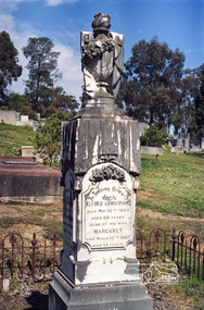
Negative - Photograph, Harry Gilham, Grave of Alfred and Margaret Armstrong, Eltham Cemetery, Victoria, Sep 2009
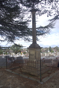
Alfred Patrick Armstrong was born in England in 1825 and was employed under the renowned Isambard Kingdom Brunel as a civil engineer during the construction of the Great Western Railway and the South Wales Railway. He came to Melbourne in 1852 and purchased property in Eltham. He became a mining surveyor and was Inspector of Mines and the Mining Registrar for the St Andrews Division of the Castlemaine Mining District. In 1855, he chaired a meeting calling for a bridge to be erected across the Yarra River between Eltham and Temple Stow. He was registered as an innkeeper in 1858, was a recognised collector of the £110 raised for the building of the first building of State School No. 209 (Eltham Primary) and was a Trustee for the Church of England site on the Eltham Cemetery Trust in 1860. He was elected to the Eltham District Road Board (forerunner of Eltham Shire Council) from 1867 to 1871 and then served as an Eltham Shire Councillor from 1871 to 1878 (including Shire President in 1873). Margaret Armstrong to whom he was married in 1854 at St Pauls Church, Melbourne, died on the 27th March 1887. Alfred died in 1893, having been in ill health for some time, and is buried in Eltham Cemetery with his wife Margaret. The monument features a tall pillar capped with a draped urn: a symbol of death. In Loving Memory of Alfred Armstrong Died May 27tth 1893 Aged 68 years Also of his wife Margaret Died March 27th 1887 Aged 63 years This burial site is of special interest as the monument has the tallest pillar-a vase-a draped cloth top (unfulfilled life) and additional panels of names around the sides and the base, which include: Ada Gertrude Armstrong, beloved daughter of Alfred & Margaret Armstrong, died May 30th 1878, aged 21 years Mary Armstrong, beloved mother to Alfred Armstrong, died April 10th, 1886 aged 82 years Arthur Vivian Harrison, died 4th Nov. 1899, aged 8 years Arthur Reynolds Stockwood Armstrong, son of Alfred Armstrong, died 4th Nov. 1908, aged 43 years Laura Augusta Harrison nee Armstrong, died 26th July 1921, aged 64 yearsRoll of 35mm colour negative film, 6 stripsKodak GC 400-9eltham cemetery, gravestones, alfred armstrong, margaret armstrong, ada gertrude armstrong, arthur reynolds stockwood armstrong, arthur vivian harrison, laura augusta harrison (nee armstrong), mary armstrong -
 Eltham District Historical Society Inc
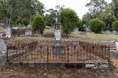
Photograph, Peter Pidgeon, Grave of Alfred and Margaret Armstrong, Eltham Cemetery, Victoria, 5 April 2021
Alfred Patrick Armstrong was born in England in 1825 and was employed under the renowned Isambard Kingdom Brunel as a civil engineer during the construction of the Great Western Railway and the South Wales Railway. He came to Melbourne in 1852 and purchased property in Eltham. He became a mining surveyor and was Inspector of Mines and the Mining Registrar for the St Andrews Division of the Castlemaine Mining District. In 1855, he chaired a meeting calling for a bridge to be erected across the Yarra River between Eltham and Temple Stow. He was registered as an innkeeper in 1858, was a recognised collector of the £110 raised for the building of the first building of State School No. 209 (Eltham Primary) and was a Trustee for the Church of England site on the Eltham Cemetery Trust in 1860. He was elected to the Eltham District Road Board (forerunner of Eltham Shire Council) from 1867 to 1871 and then served as an Eltham Shire Councillor from 1871 to 1878 (including Shire President in 1873). Margaret Armstrong to whom he was married in 1854 at St Pauls Church, Melbourne, died on the 27th March 1887. Alfred died in 1893, having been in ill health for some time, and is buried in Eltham Cemetery with his wife Margaret. The monument features a tall pillar capped with a draped urn: a symbol of death. In Loving Memory of Alfred Armstrong Died May 27tth 1893 Aged 68 years Also of his wife Margaret Died March 27th 1887 Aged 63 years This burial site is of special interest as the monument has the tallest pillar-a vase-a draped cloth top (unfulfilled life) and additional panels of names around the sides and the base, which include: Ada Gertrude Armstrong, beloved daughter of Alfred & Margaret Armstrong, died May 30th 1878, aged 21 years Mary Armstrong, beloved mother to Alfred Armstrong, died April 10th, 1886 aged 82 years Arthur Vivian Harrison, died 4th Nov. 1899, aged 8 years Arthur Reynolds Stockwood Armstrong, son of Alfred Armstrong, died 4th Nov. 1908, aged 43 years Laura Augusta Harrison nee Armstrong, died 26th July 1921, aged 64 yearsBorn Digitaleltham cemetery, gravestones, ada gertrude armstrong, alfred armstrong, arthur reynolds stockwood armstrong, arthur vivian harrison, laura augusta harrison (nee armstrong), margaret armstrong, mary armstrong -
 Melbourne Legacy
Document - Speech, Bulletin Address. Legatee Kem Kemsley Tuesday 27 September 1983
An article from the Bulletin including the text an address by Legatee Kem Kemsley at a Legacy event on 27 September 1983. He discusses the beginnings of Legacy. He relates the approach made to Sir John Monash to be the first president. It was via Legatee Frank Meldrum who was playing tennis with Monash's son-in-law. It shows the nature of relations between high ranking ex servicemen. Monash suggested Colonel Harold Cohen. Initially Legacy was founded with 'one person from each profession or business who will represent that profession until such time as the Club has established itself on a wider basis.' For example there were 'two solicitors - Downing and Armstrong, Meldrum as dentist, George Worboys as plumber, Dr Gardener as the eye specialist, Doolan and Goodchild as Surveyors, Fred Wickham of the Premier's department who was regarded as very important, Baker from Myer's Emporium, Joynt from the printing world and Blackett the architect.' He also mentions a Police Strike and General Monash set up a special constabulary force. Cohen, Kemsley and many of the early legatees answered the call to help keep peace. By December 1923 there were 54 members of the new Legacy club. The name was under consideration as the Tasmanian club was called Remembrance Club. Pip Powell nominated the name of Legacy to be submitted for consideration, but it was Frank Selleck who moved the formal resolution. By the end of 1924 initial objectives were met. A picnic with widows and children was held at Heidelberg and then Beaumaris, (limited by the few legatees who had motorcars at the time). Following thoses successes Frank Doolan posed the question 'what does Legacy really mean?' and focus changed toward widows and children. Legatee Savige had a property at Balnarring and the first camps were started. For boys there was a Lacrosse team and football team. Also swimming classes and literary and debating classes, which were hoped to be interesting and develop their minds along the proper form of citizenship. Then classes for the widows and later the girls. The article was part of an album of past presidents from 1965 to 1989. The folder included biographical details and obituaries, eulogies and death notices of prominent Legatees. The items have been catalogued separately.A record of a speech made by Legatee Kem Kemsley a past president of Legacy about events in the early days of Legacy. The information was collected to record the lives of prominent legatees in a folder.Photocopy of 3 pages from Bulletin on an address by Legatee Kem Kemsley in 1983.Bulletin No. VAW 1209. 6.10.1983. Page No 8, 9 and 10.past presidents, speech, kem kemsley, history, police strike -
 Bendigo Historical Society Inc.
Document - SPECIMEN COTTAGE COLLECTION: VARIOUS DOCUMENTS
Various documents in plastic folders. Topics are: 1. Rocky Vale Villa in Maiden Gully built by William Beebe Snr, historical information and significance assessment. 2. The powder magazines of Bendigo and Eaglehawk talk given by Ralph Birrell. 3. Ralph Birrell obituary. 4. Early Surveyors on the Bendigo goldfields 1852-1860 three pages essay by Ralph Birrell. 5. History of Eaglehawk courthouse and log lock up with four photographs. 6. Submission from the National Trust regarding Bendigo Pottery. 7. Fistcuffs, Diamonds and Lace synopsis of a novel by Ann Rayner on the boxer Abednego Thompson after whom the name of the City of Bendigo is said (by same to be derived. 8. Historical facts and dates on Bendigo by the Royal historical society of Victoria, Bendigo branch. 9. Arcades of Bendigo, by Tom Luke. 10. Benedict Branch family history with picture. Benedict invented a Miners Safety cage in 1883 and was awarded a medal, photos of the cage and medal included. 11. Burke & Wills 150 years on pamphlet, Jim Evans newspaper article, notes and photos of the monument at the Bendigo cemetery. 12. Marlborough House document on the history of this house. 13. Codicil to the last will and testament of William Beebe of Inglewood Road, Sandhurst. 18th September 1891. 14. Document outlining the life of Sister Jessie Aitken 15. Document - W. Anderson and Sons business in Mitchell Street 'Fancy goods'' history of the family. 16. Handwritten notes on Florence Anderson. 17. Document family history of Hamlet Smart Appleby. 18. Document - Amy Castles ''The little Bendigonian singer'' 19. Quentin Clifford (Cliff Binks words in remembrance, Bendigo Monday 23rd November 2015. 20. Background report on Vahland drinking fountain, list of William Vahland buildings, copies of photos of Vahland descendants and two brochures celebrating Vahland. 21. Blank invoice for the Taraxale Brewing Co. of Golden Square - G. A. Pethard, manager. -
Glen Eira Historical Society
Article - Glen Eira
... Surveyors ...Six items about the Glen Eira Mansion. Letter dated 2/06/2012 from the St Kilda Historical Society to Glen Eira Historical Society asking for further information as well as providing some items on Glen Eira’s history Attachment to above letter of information about Glen Eira printed from Melbourne Mansions Database on 30/05/2012 about Glen Eira House referencing the Argus newspaper for 10/03/1865 and 25/07/1881, ‘Sand, Swamp and Heath’, ‘Caulfield’s Building Heritage and Pioneer Families’. Entry is dated 27/06/1997. Second attachment to above letter of a memo detailing information about Glen Eira mansion form History and Heritage Officer at City of Glen Eira together with an image extract of birth notices from the Argus 22/5/1863 re the birth of a daughter to W.Lamborn Esq on 20/05/1863 at Glenalry house Caulfield Third attachment to above letter of questions and parish plan image re properties including area occupied by Glen Eira from Heritage Officer St Kilda Historical Society Southern Scenarion quarterly newsletter of the Royal Southern Memorial Hospital Issue No. 7 Winter 1988. It contains a black and white photograph of Glen Eira with a brief history of the residence and owner on P 2 plus an article on P 3 about the bequest from the late Rudolph Ashley Ricketson for the Ashley Ricketson Centre in the hospital. Demolition of the mansion occurred in 1965. Newspaper article (source & date unknown) about the bequest from Ashley Ricketson of $10.5 million to the Southern Memorial Hospital in Caulfield. It is on the site of Glen Eira, demolished 4 years prior. A sketch and photo of the hospital.glen eira, glen eira house, ricketson henry, lamborn william, kooyong road, caulfield, alison road, seymour road, beemery park, elsternwick, watts thomas, mansions, sargood frederick, rippon lea, australian general military hospital no. 11, southern memorial hospital, architects, staniforth georgina, were edith alice mary, were jonathon binns, fulton thomas, caulfield district crown land, glen huntly road, glen eira road, hawthorn road, military hospitals, ricketson rudolph ashley, towers, jacka albert captain vc, the white house, soldiers, hospitals, caulfield geriatric hospital, glenalry, caulfield roads board, foot henry boorn, surveyors, southern scenario, ashley ricketson centre, royal southern memorial hospital, best joan mrs, caulfield grammar school, the white house, barrata, house names -
 Kiewa Valley Historical Society
Set of 4 photographs of SECV Clerical staff, 1940 - 1941
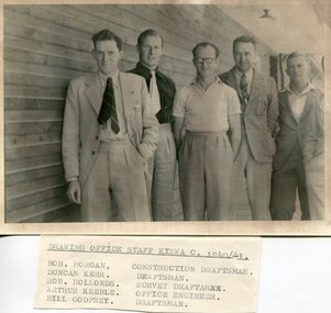
The Kiewa Hydroelectric Scheme is the largest hydro-electric scheme in Victoria and the second largest in mainland Australia after the Snowy Mountains Scheme. The scheme is situated in the Australian Alps in north-eastern Victoria about 350 km from Melbourne and is wholly owned by AGL Energy. The scheme was originally constructed between 1938 and 1961 by the State Electricity Commission of Victoria although it was privatised in the 1990s. The scheme was originally developed solely for electricity generation, unlike the Snowy Mountains Scheme, which was also intended to direct water west of the Snowy Mountains for purposes of irrigation. From 1937 to 1944 the construction of dams at Pretty Valley, Rocky Valley and the Junction Dam were undertaken requiring large numbers of planning and support staff to see the projects successfully completed. Planning and support staff were the backbone of the successful completion of the Kiewa Valley Hydro Electric Scheme and contributed significantly to the development of the Kiewa Valley area. Many descendants of the men in the photographs still living and working in the local areaSet of 4 black and white photographs of SECV clerical staff – Circa 1940/1941Typed on note glued to back of each photo, Numbers handwritten in blue ink in top left hand corner 1. DRAWING OFFICE STAFF KIEWA C. 1940-41 Bob Morgan – Construction Draftsman; Duncan Kerr – Draftsman; Rob Hollands – Survey Draftsman; Arthur Keeble – Office Engineer; Bill Godfrey – Draftsman 2. CLERICAL OFFICE STAFF KIEWA Peter Harnetty – Clerical; Bert Connors – Clerical; John Martin – Stores Clerical; Ken Calder – Head Storekeeper; Bill black – Construction Records 3. CLERICAL OFFICE STAFF KIEWA Jack Norman, Herb Kendall, Jack Bray – Stores Clerical; Ken Calder – Head Storekeeper; Jim Swain, George Milner – Stores Clerical; Jim Gleeson – Storekeeper; John Martin – Stores Clerical 4. OFFICE STAFF KIEWA C. 1940 Don Faulkner – Cadet Engineer; Tas Davies – Survey Draftsman; Bob Morgan – Construction Darftsman; R.J. Martin, Arthur Keeble – Office Engineers; Rob Hollands – Survey Draftsman; Jack Wollard – Head Surveyor; Harry Wilson – Plan Officer. Printing Plans Handwritten in red ink on back of photo 4 – Refer Rob Hollands secv clerical staff -
 Bendigo Military Museum
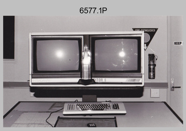
Photograph - AITA Award - RA Svy’s AUTOMAP 2 Computer Based Map Production System, Army Survey Regiment, Fortuna, Bendigo, 1984
This collection of three photos of the Australian information Technology Award (AITA) won by the Royal Australian Survey Corps (RA Svy) AUTOMAP 2 computer-based map production system, was taken in 1984 at the Army Survey Regiment, Fortuna, Bendigo. The following article appeared in the ARMY Newspaper on Thursday 21st February 1985. ‘In computerised map production. Survey soldiers lead the world. BENDIGO: Army surveyors have been put on the map as world leaders in computerised map production following the Australian information Technology Awards. RA Svy won the Computer Assisted Draughting – Mapping section for its Automap II System which has created considerable interest among overseas defence experts. The award for the digital mapping system was accepted by OC Air Survey Sqn, MAJ Rob John, who said it was a great morale-booster for the soldiers of the Bonegilla (sic)* -based Army Survey Regiment. "Setting up a state-of-the-art system like Automap II. is an enormous task, " he said. "We started in August 1983 and it's only recently that we have achieved production results. "We were all very pleased to have our efforts recognised in this way. “Of course, credit must also go to the Intergraph Corporation for manufacturing the system and carrying out most of the development." RA Svy is responsible for producing all of Australia's maps used for defence purposes. Its topographical maps have a scale of 1:50,000 or 1:100,000 although Automap II has the capability of producing smaller scale maps - down to 1: 2,000,000. Automap II consists of three computers and three sub-systems: input, raster scanning, and graphic edit. The input sub-system has eight stereo plotters, two interactive graphic workstations and a system manager workstation. The stereo plotters use superimposition optics to digitise features from aerial photographs. It incorporates a voice recognition system so the operator can simply say "House", "Windmill", etc; and the relevant feature will be incorporated in the digital picture. Individual map separations are scanned and converted by the raster scanning sub-system to a digital raster image. This image is then converted to a graphics file in Intergraph format.’ *Note – the Army Survey Regiment was located in Bendigo, not Bonegilla as incorrectly stated in the article. The article appears on Page 137 of Valerie Lovejoy’s book 'Mapmakers of Fortuna – A history of the Army Survey Regiment’ ISBN: 0-646-42120-4. Additional history of the AUTOMAP 2 system with historic photographs is covered in pages 119, 137-143 and 157 of the 'Mapmakers of Fortuna’ book. See item 6223.23P for additional history and photographs of the AUTOMAP 2 system.This collection of three photos of the Australian information Technology Award (AITA) won by the Royal Australian Survey Corps (RA Svy)’s AUTOMAP 2 computer-based map production system, was taken in 1984 at the Army Survey Regiment, Fortuna, Bendigo. The photographs are printed on photographic paper and are part of the Army Survey Regiment’s Collection. The black and white photographs were scanned at 300 dpi. .1) - Photo, black & white, 1984, AITA Award sitting between the dual screens of an AUTOMAP 2 Graphic Edit Workstation. .2) - Photo, black & white, 1984, MAJ Job Johns (centre) and two of Intergraph Corporation IT engineers proudly hold the AITA Award next to an AUTOMAP 2 Graphic Edit Workstation. .3) - Photo, black & white, 1984, The AITA Award displayed on a pedestal in the Army Survey Regiment Officers Mess. .1P to .3P –No personnel are identified. ‘AITI Award to AUTOMAP II 1984’ annotated on cover sleeve. royal australian survey corps, rasvy, army survey regiment, army svy regt, fortuna -
 Flagstaff Hill Maritime Museum and Village
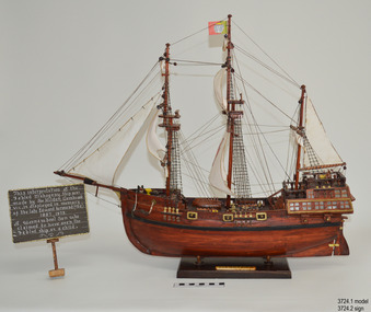
Craft - Ship Model, Portuguese Carvel, 1999
The Mahogany Ship is today regarded as a legend and refers to an ancient wreck that is purported to lie beneath the sand beside Armstrong Bay, several kilometres west of Warrnambool, Its location is currently unknown. For well over a century the mystery of this ship has fascinated Australians because the existence of such a vessel could throw a different light on the earliest phases of exploration of eastern Australia by Europeans. The story is that in January 1836 a party of whalers from Port Fairy travelled to the mouth of the Hopkins River in search of seals. Their boat overturned and one man was drowned. The three survivors were walking the 30 kilometres back to Port Fairy along the coast when, about halfway along, they discovered the wrecked ship in the dunes. It is said that Captain John Mills, who was in charge of the whaling station at Port Fairy promptly visited the wreck with several of his men, including Hugh Donnelly. Donnelly who was the originator of that version of events is now regarded as unreliable. Local history researcher Joan Fawcett believes Donnelly could not have visited the wreck in 1836 because he did not arrive in Victoria until 1841. The "mahogany" description can be traced to a letter from Port Fairy builder, architect and surveyor John Mason and published in the Melbourne Argus in 1876. He said he had seen the hull in 1846 and it "had the appearance of either cedar or mahogany." In 1884 Argus journalist `The Vagabond' wrote that the hull was built of "Spanish mahogany" and six years later Mason wrote another letter saying it might not have been mahogany but red gum or ironbark from New South Wales. He was too late with this new description as the wrecks mahogany tag was here to stay all through the hull was not visible as it had disappeared beneath the shifting sands by 1880. A more reliable account was later presented by the former editor of the Warrnambool Examiner, historian Richard Osburne, who wrote about the wreck in his book History of Warrnambool (published 1887). In it the author remembers to have noticed a wreck in the hummocks between Belfast and Warrnambool, in 1847 or 1848; he stated it was much nearer Warrnambool than Belfast, now known as Port Fairy, going on to state “in fact, it was only two or three miles from the former place, to the west of the big hummock which was supposed to fill Warrnambool Bay with drift sand washed by the Merri River before the cutting was made.” Osburne followed up with a letter to the Port Fairy Gazette on June 25, 1876, during a period of heightened interest in the wreck, although he was unsure of the provenance of the ship he went on to state in his letter. “The old wreck was, in fact, miles away from the Port Fairy beach, and only about four miles from Warrnambool. In the years 1847 and 1848. I have often seen the wreck and I regret to say I do not believe she was a foreign ship at all.”The ship model is significant for its association with the Warrnambool story of what is now referred to as the Mahogany Ship, an ancient shipwreck. The model is significant as it is an interpretation of a Portuguese caravel and possibly associated with the early history and exploration of Southern Australia. The model is a fine example of a hand crafted ship made from plans, not from a kit. Some of the materials used for the model are significant to the Gembrook community in that the timber used is a portion from a 30-meter pine tree that fell onto and destroyed the 120-year-old Gembrook church building. The model is also a dedication to Edward Kermond, who grew up in Warrnambool and claimed to have seen the shipwreck in the dunes when he was a lad in the late 19th century. (See note section of this document for further information on the creator and donation of the subject item).Ship model, an interpretation of a mahogany Portuguese carvel vessel in a glass display case with wood frame and a description plaque. Model is made from dark stained wood. The three masted vessel is fully rigged, with a Portuguese-like flag on mast. Plaque is rectangular, free standing on a pedestal. The model was handmade by Joe Hilder (Senior) in 1999 from flooring obtained from the Gembrook Uniting Church in Victoria. Inscriptions, hand written, under base of case and on plaque.Under base, black felt tip pen “Ship & Case made From / Flooring from Gembrook uniting Church, Flattened in 1999 / By Large Pine Tree.” On plaque, white paint "This interpretation of the Fabled Mahogany Ship was made by Joe Hilder, Gembrook Vic. is displayed in the memory of the late Edward Kermond (Ted) 1887-1973, a Warrnambool son who claimed to have seen the original ship as a child." flagstaff hill, warrnambool, flagstaff hill maritime museum, shipwreck coast, flagstaff hill maritime village, great ocean road, ship model, mahogany ship, mahogany ship story, portuguese caravel, joe hilder, edward kermond, ted kermond, gembrook uniting church, gembrook storm 1999, port fairy whalers, belfast whalers -
 Eltham District Historical Society Inc
Negative - Photograph, Warrandyte Bridge over River Yarra, c.1910
View of the 1875 timber trestle bridge over the Yarra River reproduced from a newsprint image. Also known as Anderson's Creek (Road) Bridge A contract was accepted for William Elliot to erect a bridge over the Yarra River at Warrandyte on Anderson's Creek Road and other improvements for £1,331.6.2 - Gazette No. 143. Tuesday, November 13th 1860 - http://gazette.slv.vic.gov.au/view.cgi?year=1860&class=general&page_num=2161&state=V&classNum=G143&id=). The bridge was washed away by floods in 1863. It was replaced with a taller timber trestle structure in October 1875, designed and built by C.S. Wingrove, Shire Clerk, Engineer and Surveyor for Eltham Shire Council. A replacement for this bridge was commenced in 1955 to cope with increasing traffic and this structure was widened in 2018 to meet further traffic demands. Argus (Melbourne, Vic. : 1848 - 1957), Thursday 23 September 1875, page 7 ________________________________________ THE WARRANDYTE BRIDGE. The ceremony of formally opening the newly erected bridge over the Yarra at Ander-son's Creek was performed on Monday last, in the presence of the members of the Eltham and Bulleen shire councils whose territories it joins, and a goodly number of the residents of the district. The task was delegated to Mr. Cameron, M.L.A., who, after a few introductory remarks declared the bridge to be opened, and christened it the " Warrandyte Bridge." The party then adjourned to Grant's Hotel, where a cold collation had been prepared. The chair was taken by the president of the Eltham shire (Mr. John Bell) and the vice chair by Mr. Kent, a member of the Bulleen council. Mr Robert Williamson proposed "Success to the bridge," coupling with it the name of Mr. Cameron, to whose exertions was in the main to be attributed the erection of that structure which was an ornament to the district and would prove of great service to both sides of the river. Mr. Cameron, in responding, alluded to the great difficulties, mainly of a pecuniary nature, that had been encountered in carrying out the project, and which had only been got over by their united efforts and by the liberal spirit in which the late Commissioner of Roads had dealt with the case. The healths of the contractor and the engineer were also drunk. The bridge is a trussed timber one, resting on yellow box piles sunk into the solid rock, each pier being weighted with 50 tons of stone. The abutments consist of dry stone walls, 6ft. thick at the base, and tapering to 3ft. on the top, the face of the work having a batter of 1 to 1. The length of the bridge is 308ft., there being four openings in the centre of 66ft. each, and two at the ends of 20ft. each. The width in the clear is 9½ft., and the height from the bed of the river about 33ft. The approaches comprise 1,100 cubic yards of earthwork, and the formation of 48 chains of sideling, the whole cost of the work, which was carried out under the direction of the engineer to the Eltham Shire Council, being £1,413.This photo forms part of a collection of photographs gathered by the Shire of Eltham for their centenary project book,"Pioneers and Painters: 100 years of the Shire of Eltham" by Alan Marshall (1971). The collection of over 500 images is held in partnership between Eltham District Historical Society and Yarra Plenty Regional Library (Eltham Library) and is now formally known as the 'The Shire of Eltham Pioneers Photograph Collection.' It is significant in being the first community sourced collection representing the places and people of the Shire's first one hundred years.Digital image 4 x 5 inch B&W Neg B&W Print 12.5 x 9 cmsepp, shire of eltham pioneers photograph collection, warrandyte, bridge -
 Ballarat Heritage Services
Photograph - Photograph - Colour, Burke and Wills Memorial at Bendigo Cemetery, 2018, 02/09/2018
Robert O'Hara Burke and Thomas Pope Besnard were childhood friends. As sexton of the local Back Creek Cemetery Thomas Besnard organised a subscription to raise the money for a monument to Burke, Wills and Gray. A subscription of one shilling, no more and not less, was asked so all subscribers were equal. The Bendigo monument was designed by Adam Duncan and features a Corinthian column mounted on a foundation stone, topped with a Grecian urn draped with the Union Jack. The stone for the monument was quarried from New Chum Mine. The site in the Bendigo Cemetery was selected by Besnard so the monument was on a grass knoll well clear of any other graves. The design included landscaping with a path and garden beds that provided dignified access. The Burke and Wills Monument in Bendigo has been entered on the Register of the National Estate as being important for its association with historical events and developments associated with exploration in the early days of Colony of Victoria. Two conifers remain from the original group sent by Mueller of the Melbourne Botanical Gardens to develop the garden layout on the knoll. These two trees are listed as Significant Trees by City of Greater Bendigo. The foundation block was laid on 20 August 1862 by Chairman of the Bendigo Municipality, Charles Burrows – exactly two years after the Expedition left Melbourne. A half day holiday was declared by Bendigo Council, and a procession left the Bendigo Town Hall and marched to the cemetery where 8000 people were gathered and another 4000 lined the route. John King was unable to attend due to ill health. Chairman of the Municipality of Bendigo, Charles Burrows, gave a long address, and diaries of members of the expedition, the Sandhurst Almanac, the Bendigo Advertiser, the Bendigo Independent Evening News, photographs of the deceased, photographs of Public Buildings in Bendigo, a Sydney half sovereign and all the silver coins of the Realm were wrapped in a Union Jack and placed in a niche in the foundation stone. Fifteen months later a column was erected on the foundation stone after Besnard openly criticised the Memorial Committee for their lack of action. The Bendigo Advertiser was disappointed at the location of the monument preferring a more central location and in 1893 an attempt was made to move the monument to Rosalind Park. On 19 May 1893, Mr Minto, the City Surveyor of the Bendigo MunicIpality reported it would cost £25, and no other action occurred. In 1940 the land around the memorial was sold off as grave sites and the paths and garden beds disappeared with graves now surrounding the base of the monument. The Burke and Wills Monument in Bendigo Cemetery was entered on the Register of the National Estate for its association with historical events and developments associated with exploration in the early days of Colony of Victoria. Two conifers remain from the original group sent by Mueller of the Melbourne Botanical Gardens to develop the garden layout on the knoll. These two trees are listed as Significant Trees by City of Greater Bendigo.Burke and Wills Memorial at Bendigo Cemetery, 2018Erected by the people of Bendigo in honor of the Victorian Explorers, Burke, Wills, Gray and King who first crossed the continent of Australia. King alone surviving the privation and suffering under which his three brave ill-fated companions sank. A.D. 1862. Robert O'Hara Burke, leader of the Victorian Expedition, left Melbounre 24th August 1860. Reached Carpentaria 12th Feby 1861. Died on his return at Coopers Creek, 30th June 1861. Charles Gray, died also on his return at Polygorum Swamp. 17th April 1861. William John Wills, second in command, died also near Coopers Creek, 29th June 1861. bendigo cemetery, burke and wills, burke and wills memorial, william john wills, john o'hara burke, charles gray, polygonum swamp, coopers creek, victorian expedition, carpentaria, bendigo public cemetery, bendigo remembrance park, thomas pope besnard -
 Bendigo Historical Society Inc.
Document - MCCOLL, RANKIN AND STANISTREET COLLECTION: NEW STAR GOLD MINE HARRIETVILLE NL, SOUTH BLUE CONSOLIDATED SYNDICATE
McColl Rankin & Stanistreet, New Star Gold Mine Harrietville NL. Collection of documents in envelope. a/ Agreement with the unregistered mining syndicate South Blue Consolidated Syndicate and Gold Exploration (Victoria) Co ML application No. 9982 for a Gold Mining Lease of land at Bendigo on Southern Extension of the Sheepshead or Red White & Blue Line of Reef. Dated: 17/6/1932. Signatures: James Phillips, Stanistreet, J M Leed, C J Michelsen, Jardine?? MacKay. 2 pages. b/ Harry Raymond Johnson & Ellis Douglas McDonnel Doyle on behalf of a No Liability Company to be formed, application for Gold Mining Lease NO. 7514 (Beechworth). Vendors are taking steps to a Company to be entitled New Star Gold Mine Harrietville. Signed: ??, E? McDoyle, ??, McColl Rankin & Stanistreet, ?? Dated:1/5/19/33. 2 pages. c/ Indenture between Ellis Douglas McDonnell Doyle, Harry Raymond Johnson and New Star Gold Mine Harrietville NL the company was formed on 27/6/1933 registered and incorporated. Dated 28/6/1933. Signed: Ke? E D M Doyle, Murphy, Mary R Johnson, J Nicolsen, G? Stanistreet. 2 pages. d/ Memo attached to 2-page letter. Re: adjustment of number of shares for Mr. King. Letter acknowledging receipt of paid shares. Dated 25/7/1933. Signed C B King,?? Page 2 lists brokerage etc. for shares. Dated 11/7/1933. e/ Memo & 3-page letter. Memo re surveyor for Dargo. Allotted shares exceeds available shares. Letter: To Wonnangatta Gold Reefs Syndicate regarding purchase of lease hold property in Mining District of Gippsland. Dated 28/6/1934. Signed ?? Page 2, Balance of monies advanced from R A Rankin. Page 3, costs Re Golden Butterfly Mine. f/ Agreement to lease property in Mining District of Gippsland Mining Lease No's 5187 & 5195 Black Snake Creek Dargo, blue print map of Mine included of No.5187. Dated 28/6/1934. Signed: Keohan?, ??, G ?, Geo Kingsley, Stanistreet. 4 pages. g/ An option to purchase certain Applications for Gold Mining Leases. Date: 28/6/34. Signitures: ? M Neill, ??, G ?, J Nichelsen, Stanistreet. 2 Pages.bendigo, gold mining, south blue consolidated, mccoll rankin & stanistreet -
 Kew Historical Society Inc
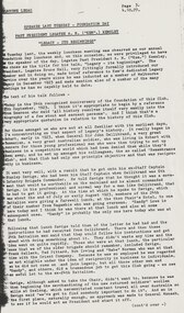
Document, Holland Loxton, Notification to the Residents of Derrick Street by the Local Board of Health, 1885, 1885
Streets and drains were the basic infrastructure problems for Kew in the 1880s. Decent streets and drains were fundamental to the quality of life of the residents. Without drainage, streets became muddy, boggy and sometimes impassable. Pools and puddles of stagnant water became smelly. The run off water, mixed with human and animal wastes, because there was no sewerage, became a health hazard. Streets and drains then became what were known as 'a nuisance'. Kew suffered from bouts of typhoid fever during the 1880s. Derrick Street was a private street on the margin of the business district of Kew and a well-used thoroughfare. We hear first about Derrick Street when the ratepayers applied to Council to have the street 'taken over' in January 1881. The Council agreed, after much debate, but ratepayers had to pay half the costs. The argument of the majority of the Council was that there was an established policy that ratepayers of private streets either had to hand over the street fully-formed or pay half the costs if Council did the work. It was felt that to make an exception for Derrick Street would create a precedent for ratepayers of other private streets. On the other hand the ratepayers, and a minority of Council, believed that there were extenuating circumstances in the case of Derrick Street. They believed that the costing by the Borough Surveyor was excessive. They felt the Council was partly responsible for the state of the street due to a channel on Bulleen Road, which deposited sand in the street. The Council had also put in some kerbing at the entrance to the street. Finally, the ratepayers believed that the street had become an important and convenient thoroughfare in Kew, and thus should be an exception to the policy on private streets. In the end a decision was delayed to allow the ratepayers to drain and form the street themselves. And there the matter stood till September 1882, when Miss Reilly complained about rubbish on a block of land in Derrick Street. So, in October 1882 the Council agreed to take over and form the street with the ratepayers paying half the costs. The ratepayers did not want to pay, so the argument continued in Council into 1883. There was a standoff for a further 18 months, until the problem could no longer be ignored. In October 1884 the Inspector of Nuisances and the Health Officer reported that Derrick Street was a health hazard as there was no drainage outlet for waste water. These reports changed the status of the problem of Derrick Street. It became an issue of public health, and thus the Council, acting as the Local Board of Health, had power to prepare plans and order the ratepayers to drain the street and pay all the costs, or let the Council do the work and charge ratepayers half the costs of the works. By April 1885, the time for ratepayers to complete the works themselves had expired, so the Council proceeded with the work and required ratepayers to pay for their share of the costs. All ratepayers had paid by the end of April except Mr Whiddycombe, who refused to pay. Mr Whiddycombe was warned to pay in October 1885. Legal action was taken against him in November. The Council lost the case on technical grounds. The Council, acting as the Local Board of Health, relaunched the legal action and won. The last we hear of Derrick Street is that seven day’s notice was given to Derrick Street ratepayers to pay for the drainage works in May 1887. We presume that Mr Whiddycombe paid. (Research: Andrew Frost)Rare and historic publication issued by the Board of Health in the Borough of Kew in 1885 to residents of Derrick street regarding the need for proper drainage for the purpose of improving public health.Printed formal notice sent by the Board of Health of the Borough of Kew to landowners in Derrick Street, Kew. The notice advised the owners that they were required to form and drain the street according to the levels and specifications approved by the Board. The letter was sent on January 23rd 1885, and signed by the Inspector of Nuisances.borough of kew -- greater melbourne (vic.), council notices -- public health, derrick street -- kew (vic.) -
 Melbourne Legacy
Document - Speech, Foundation Day Address 1977. Legacy It's Beginnings. Past President Legatee Kem Kemsley
An article from the Bulletin including the text an address by Legatee Kem Kemsley at a Legacy event on 4 October 1977. He discusses the beginnings of Legacy. He starts with Legatee Savige's tip to Hobart and Sir John Gellibrand's Remembrance Club. Then a meeting of the 24th Battalion at Phair's Hotel in 1923 and the men there agreeing to start a similar club, he mentions Sandy Lowe as a member at the meeting in 1977 that was at the initial meeting in 1923. He also mentions other at that initial meeting were Savige, Frank Selleck, Ted Pittard, Bob Irving, and 'Babe' Norman. He relates the approach made to Sir John Monash to be the first president. It was when Savige was in Frank Meldrum's dentist chair that the plan was hatched for Meldrum, (who was playing tennis with Monash's son-in-law, Gershon Bennett), to approach Monash to be president. It shows the nature of relations between high ranking ex servicemen. Instead Monash suggested Colonel Harold Cohen. Initially Legacy was founded with 'one person from each profession or business who will represent that profession until such time as the Club has established itself on a wider basis.' For example there were 'two solicitors - Downing and Armstrong, Meldrum as dentist, George Worboys as plumber, Dr Gardener as the eye specialist, Doolan and Goodchild as Surveyors, Fred Wickham of the Premier's department who was regarded as very important, Baker from Myer's Emporium, Joynt from the printing world and Blackett the architect.' He also mentions a Police Strike and General Monash set up a special constabulary force. Cohen, Kemsley and many of the early legatees answered the call to help keep peace. By December 1923 there were 54 members of the new Legacy club. The name was under consideration as the Tasmanian club was called Remembrance Club. Pip Powell nominated the name of Legacy to be submitted for consideration, but it was Frank Selleck who moved the formal resolution. The speech mentions that Sir Gellibrand was appointed Patron of Legacy and later Monash and Sir Harry Chauvel were chosen. Frank Doolan posed the question 'what does Legacy really mean?' and focus changed toward widows and children. Citing some slightly different dates to those in a later speech about the start of Legacy (at 02029) he says it was July 1926 that they met with widows and a couple of weeks later 142 boys were to attend Anzac House for a Literary and Debating class. Ballarat and Geelong had formed clubs by 1925 and Legatee Hilmer Smith was transferred with his work to Sydney and started a Legacy Club there in 1926. The first Conference was held in November 1926. The first Government House Christmas party for children was held in 1926, when the Governor General of Australia was still residing there. His final words were about his war experiences and relates a speech made by Legatee Brian Armstrong on 28th February 1961 (02502) that also spoke of the area around the Pozieres Windmill that was part of the battle of the Somme in July/August 1916, where so many of the early legatees fought.. The article was part of an album of past presidents from 1965 to 1989. The folder included biographical details and obituaries, eulogies and death notices of prominent Legatees. The items have been catalogued separately.A record of a speech made by Legatee Kem Kemsley a past president of Legacy about events in the early days of Legacy. The information was collected to record the lives of prominent legatees in a folder.Photocopy of 5 pages from Bulletin on an address by Legatee Kem Kemsley in 1977.Bulletin 4.10.77. Page No 3, 4, 5, 6 and 7.past presidents, speech, foundation day, kem kemsley, sir john monash, pozieres, somme -
 Federation University Historical Collection
Document, Establishment of the Ballarat School of Mines, 1870, 1870
The Ballarat School of Mines was the first site of technical edducation in Australasia. It is now a predecessor institution of Federation University Australia. It's first president was Redmond Barry.Correspondence and planning documents relating to the setting up of the Ballarat School of Mines. it includes tenders for contractors for the refurbishment of the former Ballarat Circuit Court. .1) Rules for the pupils of the Mining School at Zurickau, 18/11/1870 (not translated by Emanuel Steinfeld, perhaps by W. Henderson) .2) Regulations of the Mining Academy at Frieberg, 18/11/1870 .3) Einrichtungen, Freiberg, 1870 (written in German) .4) Letter from Somerville Learmonth of Ercildoun to Harrie Wood, Clerk of the Board of Mines Ballarat, accepting a position as one of three trustees of the Ballarat School of Mines, along with Redmond Barry and R.H. Bland, 08/01/1870 .5) Printing order with Robert Wreford, 26/01/1870 .6) H. Waymouth to Mr Bickett re the Ballarat School of Mines, 1780 .7) Letter from R.H. Bland of Clunes to Harrie Wood of the Ballarat Mining Board, 27/01/1870 .8) Letter from Somerville Livingstone Learmonth of Ercildoun to Harrie Woods of the Ballarat Mining Board refusing the offer to be a Trustee of the Ballarat School of Mines, 28/01/1870 .9) Minutes of the meeting of the Ballarat School of Mines Executive Council, 05/02/1870 and Correspondence from Harrie Wood to J. Warrington Rogers re the lease of the building for the Ballarat School of Mines, 21/01/1870 .10) Chief Secretary's Office to Ballarat Mining Board re Life Membership of the Ballarat School of Mines, 02/02/1870 .10b) Letter from Redmond Barry, Carlton Gardens, Melbourne re the visit of the Governor of Victoria to the Ballarat School of Mines, 04/02/1870 .12) Letter from Charles Pucke on behalf of Mr McCulloch to H, Ainswood, Secretary of the Ballarat Mining Board, 11/07/1870 .13) Correspondence from Henry Rosales of Walhalla (Chairman of the Gippsland Mining Board) to James Baker of the Ballarat School of Mines, 28/12/1870 .11) Meeting of the Executive Council, Bickett, Eddy Downes, 08/02/1870 .14) Letter from John Phillips, contract surveyor of St Arnaud to Mr Newman, Vice-President of the Ballarat School of Mines, 15/12/1870 .15) Articles ordered and obtained for the Ballarat School of Mines, 03/01/1870 .16) Telegram from John Lewis of Clunes to the Ballarat School of Mines. .16b) Quote from painter Thomas Robson for painting the Ballarat School of Mines, 05/06/1870 .17) Note from Duncan Gillies to Harrie Wood re grant for the Ballarat School of Mines, 05/06/1870 .18) Correspondence re Grant to the Ballarat School of Mines, Duncan Gillies, 04/07/1870 .19) Correspondence concerning the Ballarat School of Mines from F. Valient to Harrie Wood, 14/05/1870 .19b) Correspondence from Somerville Livingstone Learmonth to Harrie Woods - an apology for a meeting with Judge Rogers, 23/05/1870 .20) Letter from R.H. Bland to Harrie Wood, 15/07/1870 .22) Telegraph from J. Warrington Rogers to Harrie Wood of the Ballarat Mining Board concerning tenders for the Ballarat School of Mines, which was established in 1870. .23) Letter from Ballarat Mining Board to Judge Warrington Rogers, 31/05/1870 .24) Telegraph to Harrie Wood of the Ballarat Mining Board from J. Warrington Rogers concerning Sir Redmond Barry. A note at the bottom of the telegraph notes ‘This telegram has been delayed through repairs on line. .25) Letter on Melbourne Public Library Letterhead from librarian Augustus Fulk, 05/08/1870 .26) Letter from R.H. Bland to Harrie Wood, 30/05/1870 .27) Letter from Robert Park re alteration of the former Ballarat Court House for use as the Ballarat School of Mines, 05/05/1870. .28) Letter from G. Whitty re painting of the former Ballarat Court House for use as the Ballarat School of Mines, 04/05/1870 .29) Letter from William Newman re plastering of the former Ballarat Court House for use as the Ballarat School of Mines, 05/05/1870 .30) Letter from Charles A. Abbott re teaching Mechanical Drawing at the Ballarat School of Mines, 04/04/1870 .32) Letter from Redmond Barry to the Ballarat School of Mines, 07/1870 .31) National Insurance Company of Australia insurance for the Ballarat School of Mines (former Ballarat Circuit Court), 01/05/1870 .33) Letter from R.H. Bland to Harrie Wood, 09/1870 .34) Letter from Somerville Livingstone Learmonth to Harrie Wood, 06/09/1870 .35) Letter to the Chief Secretary to the Ballarat School of Mines Library & Museum, 30/11/1870 .36) Parliament house (Kitto) to the Ballarat Mining Board, 15/11/1870 .37) H. de la Poer Wall of Grenville College to R.W. Newman of the Ballarat School of Mines, 27/04/1971 .38) W.H. Odgers to the Ballarat East Town Clerk, 20/05/1870 .39) Correspondence to the Borough of Clunes for the Ballarat Mining Board requesting a grant to set of a school of mines at Ballarat. 25/03/1870 .40) Surveyor to Harrie Wood, Mining Registrar, 27/04/1870 .40) Letter to Judge Warrington Rogers re the contractor's account for satisfactory completion of work on the Ballarat School of Mines, 11/07/1870 .43) Desks for the Ballarat School of Mines by Henry Gough, 1870 .44) Ballarat Star Office to James Baker of the Ballarat School of Mines, 1870ballarat school of mines, frieberg mining academy, learmonth, somerville learmonth, wreford, weymouth, bland, rivet henry bland, barry, redmond barry, mcculloch, phillips, john phillips, robson, gillies, duncan gillies, warrington rogers, melbourne public library, whitty, robert park, newman, william newman, charles abbott, janes baler, de la poer wall, odgers, louis le gould, wood, harrie wood, steinfeld, emanuel steinfeld, ainswood, pucke, thomas robson, telegraph, telegram, state library of victoria, fulks, architecture, reed, j. reed, rosales, abbott, charles a. abbott, mechanical drawing, drawing, ballarat circuit courthouse, ballarat courthouse, national insurance company of australia, grenville college, chief secretary's office, robert sandon, school of mines, schools of mines, establishment, ballarat school of mines establishment, germany, london, ercildoun -
 Federation University Historical Collection
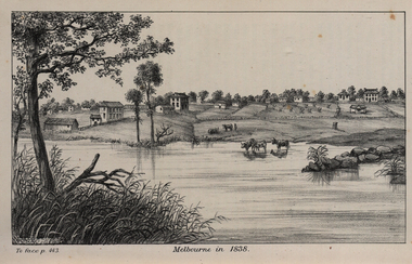
Image, John Helder Wedge, Melbourne in 1838, 1938
The following information is from http://melbourneday.com.au/about.html, accessed 30 August 2016 Melbourne was founded on 30 August 1835 by settlers who sailed from Van Diemen’s Land (Tasmania) aboard the schooner Enterprize. They landed on the north bank of the Yarra River and established the first permanent settlement, close to where the Immigration Museum at the Old Customs House — on the corner of William and Flinders Streets — stands and the place today known as Enterprize Park. Melbourne Day Committee was established to help correct the record about the founding of Melbourne and celebrate its anniversaries. The settlers came from Launceston in search of sheep-grazing land. Land had become expensive and there had long been stories told by whalers and sealers working in Bass Strait of fertile land to the north. This was the southern part of the colony of New South Wales, which the Colonial Government did not want settled at that time. After the Henty family crossed Bass Strait and settled at Portland in 1834 others quickly followed. The north bank was chosen because a small waterfall, or rapids, stopped further progress up the river. The waterfall also separated the tidal movement, providing a vital supply of fresh water. The site had previously been noted by the colony of New South Wales' surveyor, Charles Grimes, in 1803. The north bank also offered more stable, suitable ground. The people of the Kulin nation are the traditional owners of the land that became Melbourne — including the Boonwurrung, Woiwurrung, Taungurung and Djadjawurrung people, who gathered in this place for ceremonies and cultural activities. The topsail schooner Enterprize you see today is a full-size replica of the one that brought the settlers and has become a symbol of Melbourne Day. Her keel was laid at Polly Woodside Maritime Museum in 1991, and the $2.5 million, 27m vessel was launched by Felicity Kennett on 30 August, 1997, at Hobsons Bay. The original ship was bought by John Pascoe Fawkner in April 1835 specifically to search for a suitable place for a settlement in the Port Phillip District. After helping establish Melbourne, the original Enterprize continued operating as a coastal trading vessel for a number of years. She eventually disappeared off the shipping register in 1847, having been wrecked on a sand bar in the Richmond River in northern NSW, with the loss of two lives. The replica is managed by the Enterprize Ship Trust, a not-for-profit organisation. The first settlers were those on board the Enterprize — her crew and passengers. They were John Lancey , master mariner and Fawkner’s representative; Enterprize's captain, Peter Hunter; George Evans, plasterer/builder; carpenters William Jackson and Robert Hay Marr; Evan Evans, George Evans’ servant; and Fawkner’s servants ploughman Charles Wise, general servant Thomas Morgan, blacksmith James Gilbert and his pregnant wife, Mary. And Mary's cat! Enterprize set sail on her historic voyage from Launceston on July 21, 1835, stopping at George Town in northern Tasmania where creditors detained Fawkner. He was therefore not part of the first trip to Melbourne. Enterprize then left on August 1 under the command of captain Hunter. The expedition was led by Lancey, Fawkner's delegate. The party first considered Western Port and the eastern side of Port Phillip for a place to settle, before deciding on the Yarra’s north bank — known today as Enterprize Park. On Sunday, August 30, they disembarked and began to erect shelter, build a store and clear land to grow food, thus starting the permanent European settlement of Melbourne.Image of the fledgling town of Melbourne on the banks of the Yarra River. melbourne, yarra river, john helder wedge -
Port Fairy Historical Society Museum and Archives
Photograph, Mason, John
Captain John Mason came from Stirling in Scotland, arriving at Port Fairy in 1844. One year after James Atkinson obtained his Special Survey of the area. Thus his life covers all the history of Port Fairy when it was known as Belfast. He married Jane Murray in Portland in 1846 and they had 5 children, Jane died in 1855 and ten years later he married Ann Brown widow of Abijah Brown. They had no children and she died in 1887. In due course he became known as Captain Mason, he was not a sea captain, but captain of the Belfast Volunteers, a Rifle Corps formed in 1859 as a consequence of the Crimean War, and later reconstituted as the Belfast Volunteer Corps. For 40 years he displayed a remarkable versatility in his various occupations. Starting as an Innkeeper - he took over the Stag Inn from Captain Saunders in 1852, for 3 years. He then became a carpenter, stonemason, architect, estate agent honorary technical advisor to the Borough and treasurer to the Shire, and Savings Bank Secretary. They thought so well of John mason in Belfast that they elected him to the first Roads Board in 1853 and to the first Municipal Council in 1856. He was Chairman four times and with Councillors David Talbot and Joseph Whitehead designed the Council's Common Seal and the Motto "Commune Bonum".He was the first Mayor of the Borough in 1863 for a period of 7 weeks. He was responsible for the design, supervision or construction of many of the buildings in the town; most still standing today. He built the Rosebrook Bridge in 1855 and the first official Post Office ( a timber structure in Bank Street) in 1857, replacing it with a stone office in 1865. he built the Court house in 1859 and completed the breakwater between Rabbit Island and Griffith Island started by James Atkinson and John Griffith in 1849, also the first bridge over the Moyne river which connected with Battery Lane and the Bay. Among the many buildings associated with John Mason are Gobles Mill, Tynemouth Villa, 10-12 Princes Street, the Mechanics Institute, the Commercial Hotel, Yambuk and Mickey Bourke's Pub in Koroit. However, he did not build "Riverdale" in Gipps Street as is thought. He had a store and workshop on this site but sold the property in 1872 before the house was built. After an almost uninterrupted term as Councillor starting with the Municipality in 1856, John resigned from the Council in 1873. He well deserved the illuminated address they gave to him and the toast that they drank in the Bank Hotel champagne. Within the year he was working for the Borough as its engineer., surveyor, general supervisor and advisor of public works, simply as the man to whom all difficult problems were referred and at very little expense. John Mason was a great worker for his town and devoted himself unsparingly to the community. That his work was appreciated was shown by the way in which people rallied to his aid when, in the end, he found himself in financial difficulties and his reputation was challenge; arrested for embezzling from the Savings Bank of which he was the actuary in 1882. The money was repaid and the charges found not proven at his trial. He was an early member of the Loyal Prince Albert Lodge, and a founding member of the smaller Loyal Belfast Lodge in 1863. He was also a member of the Horticultural Society. Captain John Mason Died on the 14th of October 1891 (see also 62-04-046 photo)Sepia photograph on heavy cardStevenson & McNicoll photo. 108 Elizabeth Street Melbourne copies can be obtained at anytimedefence, captain, mason, carpenter, councillor, mayor -
 Flagstaff Hill Maritime Museum and Village
Photograph - Vessel "Strathgryfe", late 19th or early 20th century
This photograph was one of ten photographs donated to Flagstaff Hill Maritime Museum and Village by Fred Trewartha. Frederick John Fox Trewartha (Fred) was a well-known Warrnambool businessman. He was born in Beeac near Geelong in 1920 and came to Warrnambool with his family as a very young child. He was apprenticed to his father John, as a saddler and later opened his own shop on Raglan Parade. He then moved into working with tarpaulins and canvases for the trucking industry. Fred was keenly interested in photography (and was a member of the Warrnambool Cine Club), yachting and boat building. He kept his yacht moored at Port Fairy for many years and participated in sailing events locally and interstate. He also built boats with his sons. He had the opportunity to meet many older sailors and it's thought this photo (and others in the set) may have been given to him by one of these men. Fred Trewartha died in 2016 in Warrnambool. The "Strathgryfe" was a four masted steel barque built in 1890 by "Russell and Company", Port Glasgow and was owned by Duncan McGillivray (The Strathgryfe Ship Company Limited), Greenock. It arrived in Melbourne in December 1891 from New York. Between 1891 and 1910 it carried merchandise in and out of Australia to ports around the world - Melbourne to London (1892), Newcastle to San Francisco (1894), Capetown to Newcastle (1894), New York to Shanghai (1897), New York to Melbourne (1898), Frederickstadt to Melbourne (1899), Liverpool to Sydney (1900), San Francisco to Brisbane (1903), Newcastle to Pisagna, Chile (1905) and Rotterdam to Melbourne (1910). It carried breadstuffs from San Francisco, coal from Newcastle, wool from Sydney, saltpetre from Hamburg and wheat from Brisbane and Melbourne as well as a variety of general merchandise. In 1898, whilst on route between New York and Melbourne, it came across the Captain and crew of the missing barque "Glen Huntley" which had been reported as "lost" several months earlier. They had been marooned at Tristan D'Acunha (a remote group of volcanic islands in the South Atlantic ocean). Captain McIntyre, of the Strathgryfe, offered to bring Captain Shaw (of the Glen Huntly) on to Melbourne with them but the "old mariner" decided to stay on with his crew till arrangements could be made for rescuing the whole of them. In 1899, when in Melbourne, seven of its crew refused to go to sea in it due to its unsafe conditions. They said the vessel was unseaworthy and that the rigging was unsafe and the lifeboats, not watertight. The Captain (Donald McIntyre) denied the allegations and produced a marine surveyor's certificate as evidence of the condition of the vessel. The men were sentenced to three weeks imprisonment. In 1901 there was a fire on board the Strathgryfe just after it left Sydney for London which resulted in many bales of wool being destroyed. In 1902 it was beached at Shellback island (near Wilson's promontory) for several weeks and had to be considerably dismantled in order to lighten its load enough to allow tugs to pull it back into deep water. In 1910 it was sold to a German firm and renamed "Margretha". It continued to operate in Australian ports until 1914 when it left Sydney for the English Channel with 42,438 bags of wheat. However owing to W.W.1 breaking out, it made for the port of St Michael's where it remained for twenty-one months. Later it was seized by the Portuguese Government and renamed "Graciosa" and was leased back to the English Government. It was sunk by two German submarines in 1918.This photograph is significant as a record of the world wide mercantile trade Australia was engaged in at the end of the nineteenth century and beginning of the twentieth century.Black and white photograph of a four masted barque moored at a dock. The rigging and two lifeboats are clearly visible. Three large timber logs are in the foreground. On the back of the photograph, the donor's name and telephone number have been written in black ballpoint pen and the name of the ship has been handwritten (incorrectly) in pencil in cursive script.Back of Photo - donor's name and telephone number "Strarthgryfe" [Strathgryfe] / "late" / "Margurita" [Margretha]flagstaff hill maritime museum and village, warrnambool, great ocean road, shipwreck coast, strathgryfe, barque, steel barque, margretha, graciosa, frederick trewartha, mercantile trade, russell and company, merchandise, cargo ship, glen huntly, w. w. 1 -
 Eltham District Historical Society Inc
Photograph - Digital Photograph, Alan King, Allwood House, Hurstbridge, 16 April 2008
Allwood - built in 1894 by Henry Hurst’s relatives, stands near the site of his house, which was demolisherd in the 1940s. Until 1924 Hurstbridge was known as Allwood. The building, one of the district's oldest is situated back from the corner of Arthurs Creek Road and Main Road. Covered under Heritage Overlay, Nillumbik Planning Scheme Published: Nillumbik Now and Then / Marguerite Marshall 2008; photographs Alan King with Marguerite Marshall.; p17 Hurst, who was a surveyor, came to Melbourne in 1852 by default, as on the way to Sydney he contracted typhoid and was off-loaded in Melbourne. Deciding to settle near Melbourne, he selected some land near the present Eltham railway station and was one of the first to grow crops there.2 But disaster struck again, when his shack was looted and burned, while he was carting goods for sale to nearby goldfields. It was then that Hurstbridge’s first settler, Cornelius Haley, asked Hurst to manage his 160 acres (65ha) grazing property and 9000 acres (3443ha) of leased land where the present Hurstbridge stands. Hurst proved equal to the tough conditions and he and his brother, Fred, cut a track with a bullock team from the property to Romsey, where Haley had selected some land. Hurst also put up a bridge across the creek near his house, after which Hurstbridge was named. He ran the property helped by two ticket-of-leave men and others, several of whom were sailors who had abandoned ship in search of gold, and were working there temporarily. In 1866, only 14 years after coming to Australia, Hurst met an early tragic death. One day a bushranger named Burke came to the house and demanded a horse. Hurst thought the bushranger might be an officer in search of runaway sailors3 and anyway, did not like the look of him, so he refused. A tussle followed and apparently Hurst shot first.4 He was shot and died five hours later from loss of blood. Later, troopers found Burke, who was subsequently hanged. The event is recorded in the Old Melbourne Gaol. The government offered the family £500 but the family refused it as ‘blood money’. Hurst’s father, Robert, even signed a petition against the bushranger’s death, claiming one life did not replace another. Hurst’s family continued to live in the district and saw a rise in their fortunes. They bought Haley’s cattle station and built the present Allwood House, using the original home as an orchard packing shed. The present Victorian style timber house had several outbuildings including a blacksmith’s shop. The property passed on to William Gray, an orchardist and nurseryman, who married Hurst’s grandniece, Frances. The business boomed from the early 1900s when it supplied most of the orchards in the area. Gray was Eltham Shire’s President for two terms and was asked to stand for parliament, but his wife’s illness and other family commitments prevented him from doing so. Then several calamities drove the family to bankruptcy. During World War One, Gray lost more than one million pounds on trees shipped overseas, which the Lloyd’s company had refused to insure. Other factors, including the Great Depression, ruined the family’s fortunes. The land was reduced from more than 640 acres (256ha) to 50 acres (20ha) and the older members married and left. After Mr Gray died, the house was leased, until his daughter Sheila Ferguson and her husband Gordon settled there in 1951, after buying it from other family members. However in 1975 the Shire designated the property as a passive recreation reserve. The Ferguson family sold most of the land, leaving the house on 0.6 hectares.This collection of almost 130 photos about places and people within the Shire of Nillumbik, an urban and rural municipality in Melbourne's north, contributes to an understanding of the history of the Shire. Published in 2008 immediately prior to the Black Saturday bushfires of February 7, 2009, it documents sites that were impacted, and in some cases destroyed by the fires. It includes photographs taken especially for the publication, creating a unique time capsule representing the Shire in the early 21st century. It remains the most recent comprehenesive publication devoted to the Shire's history connecting local residents to the past. nillumbik now and then (marshall-king) collection, hurstbridge, henry hurst, allwood house -
 Bendigo Military Museum
Photograph - 4th Field Survey Squadron – Operation ARIGHT 93, Queensland, 1993
This is a set of 42 photographs taken during 4th Field Survey Squadron’s deployment on Operation ARIGHT 93 in North Queensland from the 30th of August to the 8th of October 1993. The Survey Field Completion area of operations was Weipa near the top end of the Cape York Peninsula. Survey parties conducted field checking of topographic maps covering Bamaga, Heathlands, Weipa, Lockhart River and Strathgordon in Perentie 110 Series Survey variant FFR Land Rovers. Hand-held Trimble and Magellan GPS receivers were used to assist with navigation and to position remote isolated features. Three Bell Kiowa LOH helicopters provided by 162 Recce Sqn supported field checking operations. Supplementary and Vital Asset Protection photography was taken by air camera operators in AAAvn Nomad aircraft from 173 Survl Sqn fitted with an RC10 aerial camera.This is a set of 42 photographs taken in 1993 durin8g 4th Field Survey Squadron’s deployment on Operation ARIGHT in North Queensland. The colour photographs are on 35mm negative film and are part of the Army Survey Regiment’s Collection. The photographs were scanned at 96 dpi. .1) - Photo, colour, 1993. Survey party in Perentie 110 Series Land Rover navigates through Cape York Peninsula sand hills. .2) - Photo, colour, 1993. Cape York Peninsula sand hills. .3) - Photo, colour, 1993. Cape York Peninsula Island. .4) - Photo, colour, 1993. Survey party in Perentie 110 Series Land Rover enters a Cape York Peninsula beach. .5) - Photo, colour, 1993. SPR Kim Baker takes a break on a Cape York Peninsula beach. .6) - Photo, colour, 1993. L to R: MAJ Andy Cordova (USA Exchange) from the Army Survey Regiment and unidentified civilians. .7) to .14) - Photo, colour, 1993. Cape York Peninsula topography. .15) - Photo, colour, 1993. Unidentified surveyor in Bell Kiowa LOH helicopter. .16) - Photo, colour, 1993. Bell Kiowa LOH helicopter circles base camp. .17) to .18) - Photo, colour, 1993. Cape York Peninsula topography. .19) - Photo, colour, 1993. Vehicle convoy taking a break. L to R: LT John Bath (Detachment OC), unidentified (x2), SPR Chris Pearse. .20) - Photo, colour, 1993. Vehicle convoy taking a break. .21) - Photo, colour, 1993. Vehicle convoy ready to go. SPR Chris Pearse. .22) - Photo, colour, 1993. Vehicle convoy on the move. .23) - Photo, colour, 1993. Cape York Peninsula topography. .24) - Photo, colour, 1993. Unidentified personnel. .25) - Photo, colour, 1993. SGT Neale ‘Tex’ Houston. .26) - Photo, colour, 1993. Ground below a Bell Kiowa LOH helicopter .27) - Photo, colour, 1993. L to R: SPR Mark Sinderberry and CPL Stuart Adrain in a Bell Kiowa LOH helicopter. .28) & .29) - Photo, colour, 1993. Ground below a Bell Kiowa LOH helicopter. .30) - Photo, colour, 1993. Base camp viewed from a Bell Kiowa LOH helicopter. .31) - Photo, colour, 1993. Cape York Peninsula topography in recovery after burn-off. .32) & .33) - Photo, colour, 1993. SPR Kim Baker contemplates crossing this bridge in his Land Rover. .34) - Photo, colour, 1993. SPR Kim Baker takes a break next to a billabong. .35) - Photo, colour, 1993. Survey party in Perentie 110 Series Land Rover crosses a creek. .36) - Photo, colour, 1993. Cape York Peninsula bush fire in distance. .37) - Photo, colour, 1993. Survey party in Perentie 110 Series Land Rover traverses a sand hill. .38) - Photo, colour, 1993. SPR Kim Baker. .39) - Photo, colour, 1993. Cape York Peninsula bush fire. .40) - Photo, colour, 1993. Cape York Peninsula topography. .41) & .42) - Photo, colour, 1993. Cape York Peninsula sand hills..1P to .42P – There are no personnel identified. ‘1993 OP ARIGHT’ annotated on negative sleeve.royal australian survey corps, rasvy, 4 fd svy sqn, op aright 93 -
 Eltham District Historical Society Inc
Photograph - Digital Photograph, Marguerite Marshall, Eltham Lower Park, 20 April 2008
Originally a race course, the park has brought the community together with a variety of activities. Published: Nillumbik Now and Then / Marguerite Marshall 2008; photographs Alan King with Marguerite Marshall.; p45 Once used for horse racing, which attracted visitors from Melbourne, the Eltham Lower Park has brought the community together with a wide range of activities. Horse riding is now enjoyed as a recreation in the park as are other sports. The park also includes the Diamond Valley Railway miniature trains and a sanctuary for the rare and vulnerable Eltham Copper Butterfly. Eltham Lower Park, with other parks, forms an almost continuous green band from Eltham’s centre, along the Diamond Creek to the Yarra River.1 Before European settlement the Wurundjeri people met on this land, particularly at the junction of the Diamond Creek with the Yarra River, which they called Birr-arung. This is commemorated by the sculpture, Not just a Pretty Place by Aleks Danko, winner of the 2000 Nillumbik Art in Public Places Award. The first European to settle here was probably Henry Foley, who in 1841 used it as part of his pastoral run. Foley sold his leasehold to Joseph Wilson in 1845, who soon after sold it to Frederick Falkiner. During the 1840s the future park was part of a government square mile (2.6 sqkm) reserve, north of the Yarra, within the Parish of Nillumbik, later named Eltham. Soon the land was used for horse racing after nearby residents cleared ten acres (4ha) in the early 1850s. A three-quarter of a mile (1.2km) race secured the winner the £10 Publican’s Prize. In response to popular demand, the newly formed Eltham District Road Board petitioned the Surveyor General of the Colony of Victoria, in 1856, for 36 acres (14.6ha) of crown land for a racecourse and recreation. By 1858 the Eltham races had become an institution. ‘Many skirmishes occurred and the way home was paved with temptation, with sly-grog for sale.3 In the early 1870s, two jockeys were sons of the police officer in charge of the Eltham Police Station, Miles S Lyons. Another ten acres (4ha) was added to the area in 1866 and 12 acres (4.8ha) – Hohnes Hill – in 1870. In 1866, two acres (0.8ha) on the creek banks became an animal pound with William Walsh the pound keeper in 1870, but this was later incorporated into the park. By 1877 the area was called a public park but horse racing and training continued into the 1920s. In the mid-1900s trotters were trained on a circuit road. In 1953 the Eltham Pony Club was established and used a cross-country course on Hohnes Hill. From the mid 1950s the club held the Eltham Easter Fair at the park, later to include a procession along Main Road from the town centre to the park. The park also attracted picnic parties and campers from the inner suburbs as did Wingrove Park, and businesses catering for visitors, sprang up on the opposite side of Main Road. Bus-loads of school children visited the park for Gould League bird days in the 1960s. In 1979 the Eltham Shire Council bought Lenister Farm, linking the park with the Yarra River. The Lenister Farm wetland includes a bird hide, viewing platform and interpretive signs.5 Pioneer Henry Stooke, later Road Board chairman, bought the 11 acres (4.5ha) - later to become Lenister Farm - from the Crown in 1862. Stooke never lived on this site and the two houses at Lenister Farm were built in the 20th century. Since its formation in 1871, the Council has controlled this crown land, which it named Eltham Park. But in the 1920s Eltham Council bought land near the town centre for a park, which it named Eltham Central Park. To avoid confusion the Council renamed Eltham Park, Eltham Lower Park. Since 2004 the Yarra footbridge has linked the park with the Yarra Valley Metropolitan Park and the Main Yarra Trail.This collection of almost 130 photos about places and people within the Shire of Nillumbik, an urban and rural municipality in Melbourne's north, contributes to an understanding of the history of the Shire. Published in 2008 immediately prior to the Black Saturday bushfires of February 7, 2009, it documents sites that were impacted, and in some cases destroyed by the fires. It includes photographs taken especially for the publication, creating a unique time capsule representing the Shire in the early 21st century. It remains the most recent comprehenesive publication devoted to the Shire's history connecting local residents to the past. nillumbik now and then (marshall-king) collection, eltham lower park, eltham park -
 Eltham District Historical Society Inc
Photograph - Digital Photograph, Marguerite Marshall, Hawthorn hedges, Eltham-Yarra Glen Road, Kangaroo Ground, 3 October 2006
Hawthorn hedges are important reminders of Kangaroo Ground's Scottish heritage. They are Registered on the Victorian Heritage Register. They are "historically significant because the planting of hawthorn hedges reflects the adoption of Eurorpean farming techniques by the Kangaroo Ground population in the period following settlement and because the grid pattern of paddocks that the Hawthorn hedges define is very different to today's farm landscapes." Covered under Heritage Overlay, Nillumbik Planning Scheme. Published: Nillumbik Now and Then / Marguerite Marshall 2008; photographs Alan King with Marguerite Marshall.; p21 Hawthorn hedges bordering Kangaroo Ground’s gently rolling farmlands are important reminders of its Scottish heritage and are rare so close to Melbourne.1 As early as the 1840s newly arrived farmers from Scotland planted hawthorn hedges around their properties, to protect crops from the numerous kangaroos and wallabies. Many of these hedges survive today. These farmers had the good fortune to settle some of the most fertile land available for cropping in the Colony of Victoria. At that time the black volcanic soil could sustain an amazing two crops a year. By the mid 1850s, 500 acres (202ha) of wheat were growing in Kangaroo Ground. But the crops were threatened by kangaroos, which were so plentiful, that Surveyor-General, Robert Hoddle, named the district Kangaroo Ground in 1838. As post-and-rail fences proved inadequate barriers for the bounding kangaroos, the Scots planted hawthorn hedgerows as they had done in Scotland. Some also used the hedges to net birds, presumably for the table. Interestingly the farmers in the bordering townships of Panton Hill and Christmas Hills, did not plant hawthorn hedges around their properties. Perhaps it was because by the time they settled in the 1860s and 1870s most of the wildlife had been gunned down by residents.2 The canny Scots planted the hedges on public land outside their own farms, as the hedgerows could spread to about five yards (five m) in width. With this impenetrable barrier Kangaroo Ground’s industrious farmers flourished to gain the economic power that saw the Shire of Eltham governed from Kangaroo Ground for 79 years (1858-1937). The Scots jealously guarded their land, so hard to get in Scotland. That is why they refused to release any of it ‘for local roads to follow easier grades as was the case in surrounding districts where roads generally followed ridgelines or streams’.3 Instead the roads were built in accordance with the magnetic bearings of their first survey in 1847 whether that suited the steep topography or not. This could force traffic to diverge when wet through Greensborough and Diamond Creek. Until 1921, the Eltham-Yarra Glen Road beside Wellers Restaurant, ‘dipped down into the upper reaches of Stony Creek’.4 Later some corners were compulsorily cut for the increasing motor traffic. As late as the 1960s, corners were cut to form sweeping curves above and alongside the Kangaroo Ground Cemetery and opposite the Emergency Operations Centre. In the latter case, the farmers – understanding their hedgerows as important heritage – insisted upon their reinstatement to conform to the altered road alignment. Kangaroo Ground’s ancient manna gums also point to the district’s history and to that of the hedgerows. The Aboriginal people had transformed the original forests into grasslands with the fires they lit to attract kangaroos, (which the Scots were to exclude by planting hedgerows). But the Wurundjeri hunters left the gums (Eucalyptus vimminalis cygnetensis), on the grasslands as ‘stalking trees’ to hunt kangaroos. The hawthorn hedges in Kangaroo Ground were neglected for around 60 years from about the middle of the 20th century. Bushfires had created gaps and the hedgerows were not trimmed. Then in late 2005, local historian Mick Woiwod, formed a group to lobby the Nillumbik Shire to restore the hedges, which could last for many centuries. Some hedges in parts of Britain date back to AD 800.5 Although the original Scottish farmers have gone, the hedges are a reminder of when they flourished in the district, which has changed little in 150 years.This collection of almost 130 photos about places and people within the Shire of Nillumbik, an urban and rural municipality in Melbourne's north, contributes to an understanding of the history of the Shire. Published in 2008 immediately prior to the Black Saturday bushfires of February 7, 2009, it documents sites that were impacted, and in some cases destroyed by the fires. It includes photographs taken especially for the publication, creating a unique time capsule representing the Shire in the early 21st century. It remains the most recent comprehenesive publication devoted to the Shire's history connecting local residents to the past. nillumbik now and then (marshall-king) collection, eltham-yarra glen road, hawthorn hedgerow, kangaroo ground -
 Ballarat Tramway Museum
Magazine, Melbourne and Metropolitan Tramways Board (MMTB), "MMTB News", 1966
Eight issues of "MMTB News" - The Magazine of the Melbourne and Metropolitan Tramways Board. Two copies of issues 1 to 6 held. Second copy added 31/8/2004. All issues printed with an cream colour paper cover with the rest of the magazine white gloss paper. 2720.1 - Vol. 3, No. 1 - 16 pages, January 1966, with a photo of the Mark VI bus No. 702 on the front cover, notes on Traffic Congestion, motor cars and supermarkets, depot masters, engineering, bus maintenance, sports and social club news. On rear cover includes a photo of a Christmas function with past senior employees - left to right - H. R. Steains (architect), H. S. McComb (Chief Surveyor), Mr. Aird, Mr. P. M. Ireland (Rolling stock engineer), J Fisher (Civil Engineer) and H. A. Warner (Secretary) 2720.2 - Vol. 3, No. 2 - 16 pages, February 1966, with a photo of counting decimal coins, Tribute to the W2 class tram written by Norm Cross, (with photo), Hawthorn Clothing Depot, retirement of Harry Munroe, introduction of decimal currency, donation of 1B bogies to SPER, tramways band, death of Neil Olsen, sports and social club news. See btm2720i9.jpg for image of the Norm Cross photograph. 2720.3 - Vol. 3, No. 3 - 12 pages, March - April 1966, with a photo of Tramways Bowl Tournament presentation on the front cover, Recent developments in public transport in North America, Vera Cruz Mexico, cable cars at Rushworth, sports and social club news and photo of the Melbourne bogies under Sydney tram. 2720.4 - Vol. 3, No. 4 - 16 pages, May 1966, with a photo of W2 321being overhauled at Preston Workshops, change over to decimal currency for accounting machines, "Tram Driver Salutes the L class tram" - written by A. Bailey, Melbourne's New Trams, retirement of Gordon Wilson, sports and social club news. 2720.5 - Vol. 3, No. 5 - 16 pages, June 1966, with a photo of the track relaying in Camberwell Rd with Camberwell fire station in background, Melbourne cable tram routes, opening and closing dates, retirement of G. H. Box, visit of SPER members to Melbourne, memories of Malvern Depot, sports and social club news. 2720.6 - Vol. 3, No. 6 - 16 pages, July - August 1966 with a photo of the view from the St Kilda Junction signal box, more trams for Russia, retirements of 31 Employees, a contest to win an old W2, St Kilda Road Junction box - and how it works - signalling and interlocking, closure of Port Melbourne bus depot, sports and social club news. 2720.7 - Vol. 3, No. 7 - 16 pages, September - October 1966 with a photo of 610 on the Maribyrnong River Bridge, during the SPER tour, "Public Transport in Big Cities" - R. Risson - with photo - see image i10, MMTB Ambulance division, new trams, trams or buses, death of Harry Hood, Chas Samuels, retirement of Jack Ferguson, Reg Maxwell, manufacture of trackwork, cable tram working, sports and social club news. 2720.8 - Vol. 3, No. 8 - 16 pages, November - December 1966 with a photo of a wedding party on a tram (Richards / Fuller), apprenticeship training, Christmas message from the Chairman, tramway canteens, art of rostering by R. Drummond, Wattle Park Chalet, clock and instrument shop at North Fitzroy, tramways band, sports and social club news.Each issue has stamped on the front cover or inside "The Australian Railway Historical Society (S.A. Branch).trams, tramways, mmtb, sper, wattle park, port melbourne, st kilda junction, decimal currency, w2 class, l class, hawthorn