Showing 23070 items matching "creek"
-
 Eltham District Historical Society Inc
Photograph, Flooding of Diamond Creek at Lower Eltham Main Road bridge, Nov 2004, 2004
Two colour photographs of the flooded Diamond Creek at the Lower Eltham Main Road bridge in Nov 2004eltham, main road, bridges, diamond creek, floods -
 Eltham District Historical Society Inc
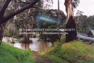
Photograph, Diamond Creek in flood, Eltham, 13 Nov 2004, 13/11/04
Three colour photographs of the floodwater from Diamond Creek crossing the path below the Eltham Community Centre.eltham, diamond creek, floods, eltham community centre -
 Eltham District Historical Society Inc
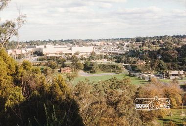
Photograph, Diamond Creek Valley, Eltham
Colour photograph looking north over the Diamond Creek Valley from the area of the Living and Learning Centre.eltham, diamond creek valley -
 Eltham District Historical Society Inc
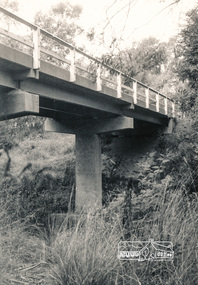
Photograph, Watsons Creek Bridge, Christmas Hills, 1970c
Black and white photograph of bridge over Watsons Creek, Christmas Hills (Clintons Road?) c.1970bridges, watsons creek, christmas hills -
 Eltham District Historical Society Inc
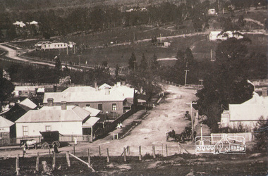
Photograph, Chute Street, Diamond Creek, 1910, looking east, 1910
Postcard of Chute Street Diamond Creek looking east, 1910 from the collection of Nillumbik Historical Society.diamond creek, chute street -
 Eltham District Historical Society Inc
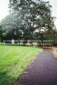
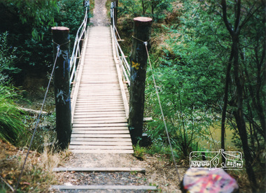
Photograph, Doug Orford, Diamond Creek Trail, Eltham
Two colour photographs showing view looking towards and entering footbridge on the Diamond Creek Trail, Elthamwalkways, bridges, diamond creek, eltham, alistair knox park -
 Eltham District Historical Society Inc
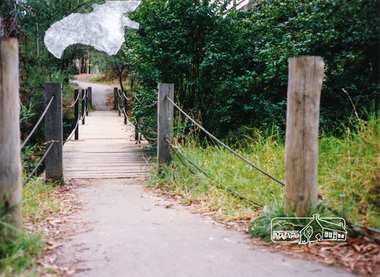
Photograph, Doug Orford, Diamond Creek Trail, Eltham
Two colour photographs showing view looking towards and entering footbridge on the Diamond Creek Trail, Elthamwalkways, bridges, diamond creek, eltham -
 Stawell Historical Society Inc
Slide, Ian McCann, Pleasant Creek c 1972
Two Glass fronted buildings with green painted brick building in background Pleast Creek c 1972stawell buildings -
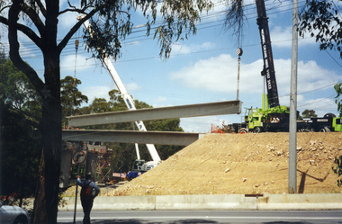 Whitehorse Historical Society Inc.
Photograph, Bridge Work Deep Creek Road, 1/02/2002 12:00:00 AM
Coloured Photo of last Span being put into place on Bridge over Deep Creek Road, Mitcham.deep creek road, mitcham. -
 Ballarat Heritage Services
Photograph - Video, Clare Gervasoni, Confluence of Canadian Creek and Yarrowee River near Anderson Street, Ballarat, 06/09/2022
The waterways of central Ballarat were channeled to prevent flooding and contain sludge during the mining era.Video of the confluence of Canadian Creek and Yarrowee River near Anderson Street, Ballarat flowing down a channel.canadian creel, yarrowee river, ballarat, anderson street, channel, bluestone -
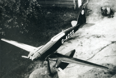 Whitehorse Historical Society Inc.
Photograph, Model on house at Creek Road Mitcham, 1939/40
Black and white 1939/40 photograph of model aeroplane on house (now demolished) at Creek Road, Mitchamcreek road, mitcham, thompson, george -
 Ballarat Heritage Services
Photograph - Colour, Clare Gervasoni, Maurie Gervasoni holds a wooden bocce ball at Yandoit Creek, 2016, 2016
Colour photographs of Maurie Gervasoni holding a wooden bocce ball used by his ancestors at Yandoit Creek.maurie gervasoni, bocce, yandoit creek -
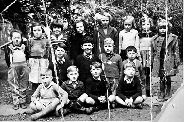 Southern Sherbrooke Historical Society Inc.
Photograph, Menzies Creek State School photo
A photograph of sixteen students from Menzies Creek State School standing and sitting for a group photo. 1950s. -
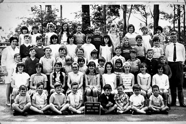 Southern Sherbrooke Historical Society Inc.
Photograph, Menzies Creek State School, 13th November 1969
A photograph shows students and two teachers from Menzies Creek State School, 13th November 1969. -
 Southern Sherbrooke Historical Society Inc.
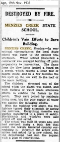
Article - Menzies Creek State School fire article, Destroyed By Fire - Menzies Creek State School
An article from The Age dated 19th Nov 1935, reporting a fire at the Menzies Creek State School. -
 Tarnagulla History Archive
Photograph, People outside Sandy Creek (later Tarnagulla) Post Office, People outside Sandy Creek (later Tarnagulla) Post Office, c.1856-1880
Murray Comrie Collection. Date of image: This office opened in August 1856. Large hoop skirt on subject suggests probably not later than 1880. This photograph is a good copy created from an older original.Monochrome photograph of people and a horse drawn buggy outside the Sandy Creek (later Tarnagulla) Post Office.tarnagulla, post office, construction, businesses, commercial road -
 Lakes Entrance Historical Society
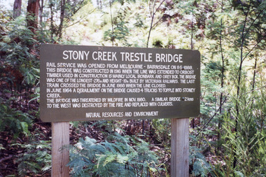
Photograph, Holding, M and Gibson, Tim, railway bridge at Stoney Creek, Nowa Nowa, Victoria, 1999
Photographs taken for Heritage Study|Eight other photographs similar viewsColour photographs showing different views of the railway bridge at Stoney Creek near Nowa Nowa, Victoriatransport, boats and boating -
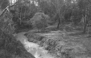
 Ringwood and District Historical Society
Photograph, Mullum Creek, 50 yards west of bridge in Ringwood Street Ringwood. May 1971
Writing on back of small photograph reads, "May 1971. Mullum Creek, 50 yards west of bridge in Ringwood St." Enlargement reads, "Mullum Creek looking west from bridge in Ringwood St. July 1972". -
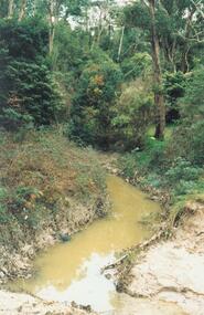
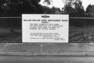 Ringwood and District Historical Society
Photograph, Mullum Creek Improvement Works (Undated - possibly 1980's)
Collection of 4 photos of Mullum Mullum Creek Improvement Works. Sign on wire fence: "Mullum Mullum Creek Improvement Works Stage 1", "This work consists of rock lining the creek banks and the construction of small rock weirs. The work will stabilize and control erosion". Estimated Cost $250,000. Undated, but phone number does not have "9" prefix. Possibly early-mid 1980's?(Photo V0174 is a duplicate of V0173 and was not scanned. There is no photo V0172)Nothing written on photograph. -
 Ringwood and District Historical Society
Photograph, Mullum Mullum Creek, east of Warrandyte Road 1986
Written on back of photograph, "3/8/86. Mullum Mullum Creek, east of Warrandyte Road." -
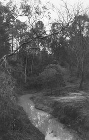
 Ringwood and District Historical Society
Photograph, Looking south across Mullum Creek from Wildwood Grove, 1972
Written on backing sheet, "Looking south across Mullum Creek from Wildwood Grove, 1972". -
 Ringwood and District Historical Society
Photograph, Mullum Creek from bridge in Warrandyte Rd. Looking east, 1972
Written on backing sheet, "Mullum Creek from bridge in Warrandyte Rd. Looking east, 1972" -
 Ringwood and District Historical Society
Photograph, Mullum Creek from bridge in Warrandyte Rd. Looking east, 1973
Written on backing sheet, "Mullum Creek from bridge in Warrandyte Rd. Looking east, 1973". -
 Ringwood and District Historical Society
Photograph, Mullum Creek looking east from bridge in Warrandyte Road Ringwood. St. Paul's extreme left, 1972
Typed below photograph, "Mullum Creek looking east. St. Paul's extreme left, 1972". -
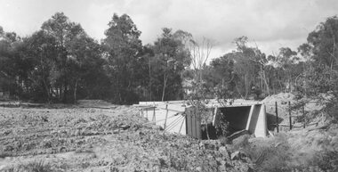 Ringwood and District Historical Society
Photograph, Bridge over Mullum Creek under construction, Oliver Street. 1963
2 photographsWritten on back of photograph, "Bridge over Mullum Creek, Oliver Street. 17/11/1963" -
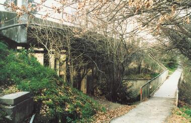 Ringwood and District Historical Society
Photograph, Warrandyte Road Bridge over Mullum Mullum Creek, Ringwood 1986
Written on back of photograph, "3.8.86. Ringwood. Warrandyte Road Bridge over Mullum Mullum Creek". -
 Upper Yarra Museum
Negative Photographic Reproduction, H. Lepoidevin falling a tree Early 1920s Hoddles Creek
H. Lepoidevin falling a tree Early 1920s Hoddles Creek Negative Black white Scanned at 600 dpi.h lepoidevin falling tree hoddles creek early 1920s -
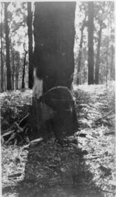
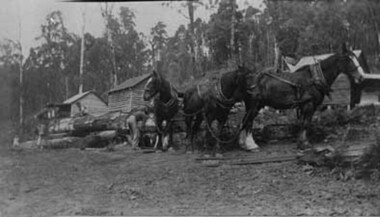 Upper Yarra Museum
Negative Photographic Reproduction, Working with horses at Mc Crae Creek mill 1945 Beenak
Working with horses at Mc Crae Creek mill 1945 Beenak Black and White negative scanned at 600 dpiworking horses mc crae creek mill beenak 1945 -
Ringwood and District Historical Society
Envelope, Packet: Dandenong Creek Committee - notes re DVA, Consultation Committee. Correspondence. 1990s
16 pages typed and some handwritten notes Dandenong Valley Authority, Dandenong Creek Community Consultative Committee -
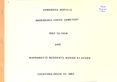 Ringwood and District Historical Society
Book, Unmarked Burials Anderson's Creek Cemetery and Warrandyte Residents Buried At Other Places
Unmarked Burials from 1867 to 1938 at Anderson's Creek Cemetery and Warrandyte Residents Buried at other places to 1867