Showing 696 items
matching forest creek
-
 Department of Energy, Environment and Climate Action
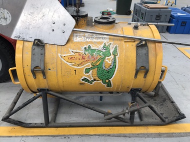
Aerial Drip Torch (ADT) or "Dragon"
The Aerial Drip Torch (ADT) was an idea conceived in Canada in the 1970s by John Muraro It was developed in 1982 by the New Zealand Forest Service to become the Ashley Aphid Helitorch. Forestry Tasmania acquired one of the machines and modified it in February 1987. Also known as a dragon helitorch it consisted of a large 135-litre tank containing jellied petrol, a displacement pump, propane ignition system, burner nozzle and fire extinguisher system. It was first trialled in Victoria at Swifts Creek in 1991 and the Aerial Drip Torch (ADT) has now become standard practice.Two Aerial Drip Torches (ADTs) were built in the 1990s by the Fire Equipment Development Centre at North Altona, They were developed in conjunction with the Department of Conservation and Land Management in Western Australia. The first was trialled during the 1991/92 autumn burning season. The machine proved to be successful and a second machine was introduced in 1998 to assist with burning operations across the State. The ADTs were commonly used for regeneration burning (controlled burning of logging slash). The first ADT introduced in 1992 had a dry weight of 160kg and a capacity of 130 litres, providing about an hour of operation. Following initial use, systematic modifications were adapted including improved ignition of gel at the drop tube, installation of an air bleed valve at the pump to assist pump priming and improved mounting brackets for the CO2 bottles and propane canister attached to the machine. The second, and lightweight ADT, introduced in 1998 had a dry weight of 68kg and a capacity of 200 litres due to a smaller lightweight frame and plastic (Polyfin) tank. In operation the ADT is suspended below a helicopter via four strops attached to the vessel and a cable to the helicopter cargo hook. Gelled fuel is dispensed via a drop tube which is attached to the pump outlet of the machine, and ignited via a gas torch. Safety features built into the first ADT were: a brass melting plug designed to be activated at 200 C bursting disc designed to burst at170 Kpa should the vessel over pressurise. a pressure relief valve set to 35 Kpa ( vessel operated between 16 &34 Kpa) a low pressure sensor designed to shut down the machine should the vessel pressure drop below 15Kpa. the vessel is filled with CO2 above the gelled fuel to eliminate ignition with in the vessel. CO2 is used to expel any residue of ignited gel from the drop tube to prevent ignition when flying outside the boundaries of the burning area. See FIRE EQUIPMENT NOTE - 46 [ https://drive.google.com/file/d/1CKtcH-3rUlrtbE9dkNP27PYT2-raVVhF/view ]forests commission victoria (fcv), bushfire, bushfire aviation, planned burning -
 Stawell Historical Society Inc
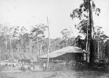
Photograph, Saw Mills at Childe’s Glenbower Creek in Halls Gap 1866
Saw Mills Halls Gap (Childe’s Glenbower Creek). Part of a collection of Photographs by Mr. O.G. Armstrong as commissioned by the Shire of Stawell for the Inter-colonial and Paris Exhibition in Melbourne in 1866. During the years of gold, the hardwood forests around Stawell were ravaged to provide timber for the mines. It was used undergrounds to shore up workings, and millions of feet of it were fed into furnaces and kilns in which the quartz was roasted. In the years after the gold boom, hardwood from the Grampians was milled for building timber. Wherever there are large tracts of natural bushland, fires are always a danger. A huge fire in January 1939 caused havoc in the Grampians, burning out towns and sawmills such as the one pictured. There have been no sawmills in the Grampian since that fire. stawell industry -
 Narre Warren and District Family History Group
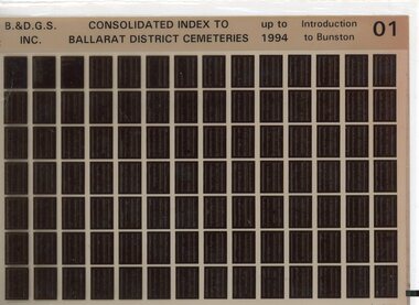
Film, Ballarat and District Genealogical Society Inc, Consolidated Index to Ballarat District Cemeteries Up to 1994, c1995
The index contains information for: Amhurst Cemetery; Avoca Cemetery; Ballan Cemetery; Beaufort Cemetery; Bungaree Cemetery; Buninyong Cemetery; Cape Clear Cemetery; Carngham Cemetery; Clarendon Cemetery; Clunes Cemetery; Coghills Creek Cemetery; Creswick Cemetery; Daylesford Cemetery; Dowling Forest Cemetery; Eganstown/Blanket Flat Cemetery; Eurenbeen East/Franklinford Cemetery; Gordon Cemetery; Greendale Cemetery; Learmonth Cemetery; Lexton Cemetery; Linton Cemetery; Majorca Cemetery; Maryborough Cemetery; Morrisons Cemetery; Mt Cole Cemetery; Mt Egerton Cemetery; Mt Prospect Cemetery; Newstead Cemetery; Rokewood Cemetery; Skipton Cemetery; Smeaton Cemetery; Smeaton House Cemetery; Smythesdale Cemetery; Staffordshire Reef Cemetery; Talbot Cemetery; Waterloo Cemetery and Waubra Cemetery.Set of 10 microfiche. non-fictionThe index contains information for: Amhurst Cemetery; Avoca Cemetery; Ballan Cemetery; Beaufort Cemetery; Bungaree Cemetery; Buninyong Cemetery; Cape Clear Cemetery; Carngham Cemetery; Clarendon Cemetery; Clunes Cemetery; Coghills Creek Cemetery; Creswick Cemetery; Daylesford Cemetery; Dowling Forest Cemetery; Eganstown/Blanket Flat Cemetery; Eurenbeen East/Franklinford Cemetery; Gordon Cemetery; Greendale Cemetery; Learmonth Cemetery; Lexton Cemetery; Linton Cemetery; Majorca Cemetery; Maryborough Cemetery; Morrisons Cemetery; Mt Cole Cemetery; Mt Egerton Cemetery; Mt Prospect Cemetery; Newstead Cemetery; Rokewood Cemetery; Skipton Cemetery; Smeaton Cemetery; Smeaton House Cemetery; Smythesdale Cemetery; Staffordshire Reef Cemetery; Talbot Cemetery; Waterloo Cemetery and Waubra Cemetery. cemeteries -- victoria -- ballarat, ballarat (vic.) -
 Lakes Entrance Historical Society
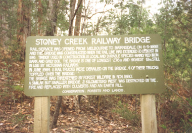
Photograph, Davies Judy, Stoney Creek Bridge Nowa Nowa Victoria, c1990
Colour photograpf of the sign erected by the Conservation, Forests and Lands Dept. at the Stoney Creek Bridge Nowa Nowa Victoria . Plus two other photos of the bridgebridges, forestry, tourism, topography -
 Clunes Museum
Map, 1962
.1 &.2 MAP OF BALLARAT SHIRE GROUP RURAL FIRE BRIGADES FIRE CONTROL MAP. COMPILED BY C. H. FENTON. (2 COPIES) DETAILING SEALED ROADS, STATE FORESTS, PINE PLANTATIONS, FOREST AREAS, RAILWAYS, BOUNDARIES, TOWNSHIP AREAS CEMETERIES, CREEKS, SWAMPS AND HOUSES.local history, document, maps, fire brigade -
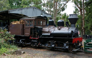 Puffing Billy Railway
Number 14 - Shay Locomotive (Builder’s Number 2549), 22 June 1912
geared steam locomotive Built by the Lima Locomotive Works, USA in 1912 (Builder’s Number 2549). “Class a” 13 Ton (13.3 tonne) . This locomotive hauled freight on the Ali-Shan Forest Railway in Taiwan and is capable of pulling 90 Tons (91.8 tone) loads over steep gradients at low speeds. . This A-type Shay locomotive was built by Lima Locomotive Works, Ohio (builder's number 2549 of 1912) for the Alishan Forest Railway, Taiwan. The Alishan Forest Railway featured a large fleet of Shay locomotives and many still survive, together with a portion of the railway which is now a tourist operation. Alishan Shay No.14 was gifted to the Puffing Billy railway in 1971 by the Alishan Forest Railway - Taiwan Government forest Bureau and arrived on the 12th October 1971 at the Puffing Billy Museum at Menzies Creek. Loco: Shay No.14 ( Shop Number 2549 ) Class: A 18-2 ( 2-cylinders / 2-trucks Class A ) Built for: Alishan Forest Railway Bulit by Lima Locomotive Corporation In service 22 June 1912 Samuels, Samuels & Co., Ltd. (D), Taipei, Formosa (Japan); For: Alishan Forest RY #14, Kirun (Keelung), Formosa, (Japan) (1945) Alishan Forest RY #14, Keelung (Chilung), Taiwan (12 Oct 1971) Puffing Billy RY #14, Belgrave, Victoria, Australia Gauge 30" Status Preserved - In Storage at Museum There is only one original LIMA mark left on any of the Alishan RY Shays and it has no number. All of their Shays have been re-built, changing much of the original Lima product. Most were renumbered for various reasons without regard to Lima Shop Numbers over the years. "Girder Type Frame" details from http://www.shaylocomotives.com/data/lima3354/sn-2549.htm Historic - Industrial Narrow Gauge Railway - Geared Steam Locomotive which worked on the Alishan Forest Railway, Taiwan.geared steam locomotive - Class: A 18-2 ( 2-cylinders / 2-trucks Class A ) - made of wood and iron and wrought iron, Glass14puffing billy, shay, geared locomotive, steam locomotive, industrial narrow gauge railway, 2'6", ali shan forest railway