Showing 806 items
matching gap road
-
 Halls Gap & Grampians Historical Society
Photograph - B/W
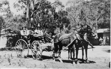
... 117-119 Grampians Road Halls Gap grampians Cottage could ...Cottage could be Gray's cottage, situated in the Fyans valley.Photo showing 2 horses hitched to a carriage in which there are 4 people, a man and a woman in the front and a man and a woman in the back. Another woman is standing inthe doorway of a cottage in the background.peoplebuildings -
 Halls Gap & Grampians Historical Society
Photograph - Coloured
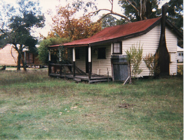
... 117-119 Grampians Road Halls Gap grampians Originally owned ...Originally owned by a Warren family, being the local baker. Warren's daughter, Ida, married Robert Greer, who continued with the bakery until retirement.Side view of cream cottage. Veranda with broken railing. Red iron roof,dark chimney and small 4-paned window on side. small tin fence at side. Autumnal tree in background. Expanse of grass in foreground. Greer's Holiday cottage (rental) c1990's. written in pencil on back.buildings, houses -
 Halls Gap & Grampians Historical Society
Photograph - B/W
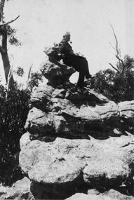
... 117-119 Grampians Road Halls Gap grampians Man was Freddie ...Man was Freddie Paash, a Danish immigrant who made his home in Halls Gap. He is seated on what was known as the 'Coronation Chair'. c1930s. This no longer exists as it was struck by lightning.Side view of Man, with hat in his hand, smoking a pipe, seated on top of rocky outcrop. Gumtrees and bush visible in background. c1930speople, paasch -
 Halls Gap & Grampians Historical Society
Photograph - B/W
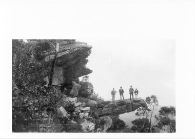
... 117-119 Grampians Road Halls Gap grampians Photo has been ...Photo has been taken from a postcard. The lookout is known as The Witch's Head, Grampians. (Numbered No. 6 this would be one of a series) c1930sThree man and a child (female?) standing on a rock ledge that just out over what appears to be a valley. Gum trees on both left and right of photo. First man has his hand on his hip. Third man is holding the hand of the child. Photo has writing bottom left and number at bottom right.scenery, wonderland range -
 Halls Gap & Grampians Historical Society
Photograph - B/W
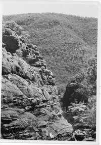
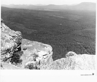
... 117-119 Grampians Road Halls Gap grampians The area is known ...The area is known as The Grand Canyon on t The Pinnacle track. Photo is typical of tourism photos taken by the Victorian Railways during this period. c1950 -60'sshows a rocky escarpment on the left with a range covered with trees in the backgroundPrinted on back: Copyright Photograph. This photograph may be reproduced on condition that it is acknowledged as 'VICTORIAN RAILWAYS PHOTOGRAPH'. P3484 Written in pencil. The Grand Canyon Halls Gap written in blue penscenery, wonderland range -
 Halls Gap & Grampians Historical Society
Photograph - B/W
... 117-119 Grampians Road Halls Gap grampians Viewing area ...Viewing area is known as The Balconies overlooking Victoria Valley. Photo is typical of tourism photos taken by the Victorian Railways during this period. c1950 -60'sa group of people (17) standing on a rocky ledge overlooking a treed valley. a second rock ledge is above them creating the impression of a large mouth. Printed on back: Copyright Photograph. This photograph may be reproduced on condition that it is acknowledged a s 'VICTORIAN RAILWAYS PHOTOGRAPH'. P3465 written faintly in pencil. The Balconies Halls Gap written in blue penscenery, lookouts -
 Halls Gap & Grampians Historical Society
Photograph - B/W
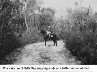
... 117-119 Grampians Road Halls Gap grampians Young woman ...Young woman is Chick Anderson (nee Warren) riding on the Dunkeld Road. It is said that this was a better section of the road. Chick has told us she was 7yrs old when this photo was taken, c1934-5a young woman seated on a horse on a sandy track surrounded by thick bush.Chick Anderson on Dunkeld Rd 1934-35 written on backaccess routes, grampians/dunkeld rd, people, warren -
 Halls Gap & Grampians Historical Society
Photograph - B/W
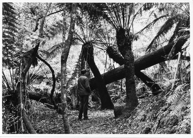
... 117-119 Grampians Road Halls Gap grampians Typical ...Typical of promotional photos taken by Forestry Commission VictoriaMan facing away from camera, on walking track, looking at large fallen tree trunk. He is surrounded by very tall tree ferns.Forests Commission, Victoria and picture logo printed in R/H white border LC.32 written on backscenery, walkers -
 Halls Gap & Grampians Historical Society
Photograph - B/W
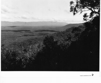
... 117-119 Grampians Road Halls Gap grampians Photo is of Moora ...Photo is of Moora Moora in the Victorian Valley. Typical of the time as a promotional image taken by Forests Commission Victoria.View over a large Valley with ranges in the distance. Roads through the valley are visible and a body of water in the middle right of the photograph. A rocky outcrop is in the left side foreground.Publicity & Public Relations Branch. When reproducing please acknowledge Forests Commission Victoria Negative no. 322-26scenery, grampians ranges -
 Halls Gap & Grampians Historical Society
Photograph - Photocopy
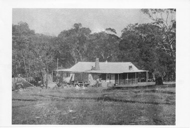
... 117-119 Grampians Road Halls Gap grampians This house belonged ...This house belonged to Walter Zumstein of the Zumsteins area. The house was burnt down in 1938. Photo was taken by Stan Parfett whose own family camped in the Zumstein area and knew Mr and Mrs Zumstein personally. c1920's This is an photocopied enlargement from a photocopied magazine article, Victoria's Heritage (see item 637)A house with veranda. A chimney (stone?) protrudes from roof at front. cleared land in foreground with old style wooden fence visible. A tank and stand situated beside house at front. Thick trees /Bush behind house.House Burnt 1938. Walter Zumstein's house. Photo by Stan Parfett. written on back.buildings, houses -
 Halls Gap & Grampians Historical Society
Document - Article (magazine/newspaper)
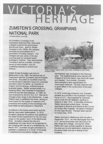
... 117-119 Grampians Road Halls Gap grampians Article (3pages ...Article (3pages) written by David Catrice for Parks Victoria. More history on Walter Zumstein and the Zumstein area can be found on p137, 153 -156, 83, 107, 136 of "Victoria's Wonderland: a Grampians History"3page Article describes Walter Zumstein and the area known as 'Zumstein's'. Entitled Zumstein's Crossing, Grampians National Park from "Victoria's Heritage", Parks Victoria c1995media, magazine articles -
 Halls Gap & Grampians Historical Society
Photograph - B/W
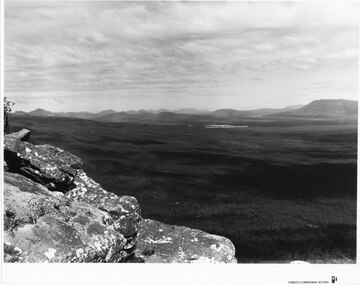
... 117-119 Grampians Road Halls Gap grampians Photo ...Photo is of the "Victoria Valley" taken from around the area of Reed's Lookout. The body of water is Moora Moora Reservoir. The background range is Victoria Range. Photo is typical of promotional photos taken by Forests Commission VictoriaRocky outcrop in foreground and a large, thick tree covered valley, with mountain ranges in the background. A body of water (near top, middle) and some roads can be seen c1960sscenery, grampians ranges -
 Halls Gap & Grampians Historical Society
Photograph - B/W
... 117-119 Grampians Road Halls Gap grampians Photo ...Photo is of Victoria Valley with Moora Moora Reservoir and the Victoria Range in the background. Photo would have been taken from around Reed's lookout area. Photo typical of promotional photos of the time by Forests CommissionLarge, densely treed valley with a body of water in background. Some roads can be seen particularly right foreground. There is a mountain range in the background. c1960sscenery, grampians ranges -
 Halls Gap & Grampians Historical Society
Photograph - B/W
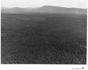
... 117-119 Grampians Road Halls Gap grampians Photo ...Photo is of Victoria Valley with the Victoria Range in the background. Photo is typical of promotional photographs taken by Forests Commission at that time.a thick bush covered valley in foreground (shadowed). Mountain range in background. Photographed from a high spot looking down and across the valley. c1960sscenery, grampians ranges -
 Halls Gap & Grampians Historical Society
Postcard - B/W
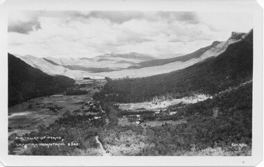
... 117-119 Grampians Road Halls Gap grampians Photo on card ...Photo on card was taken by Gilbert Rogers, a photographer and tour guide during the 1930s. This postcard is one of a series.Depicts as valley with mountains on both sides. Cleared land can be seen on either side of a road which runs through the valley. Buildings are also visible in middle area. View is running south-west.scenery, fyans valley -
 Halls Gap & Grampians Historical Society
Photograph, C 1940 -50s
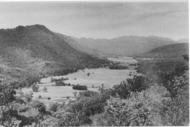
... 117-119 Grampians Road Halls Gap grampians Valley is now known ...Valley is now known as Fyans Valley but in the 1840-50s it was called Lady Mary's Vale. See p. 111 of 'Victoria's Wonderland' for historical information.A valley with a cleared area stretching along the valley floor. A mountain range runs along the left and into the distance of the photograph. a rocky outcrop, bushes and trees appear in the front and right of the photo. c 1940-1950sscenery, fyans valley -
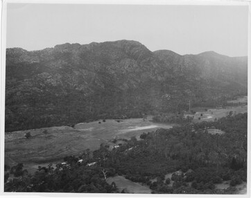
 Halls Gap & Grampians Historical Society
Photograph - B/W, C 1950s (?)
... 117-119 Grampians Road Halls Gap grampians Photograph ...Photograph is of Fyans Valley taken from Bellfield Peak. The mountain range across the centre of the scene runs north to south. The large dwelling centre-front is Bellfield Hotel, which was destroyed by fire in the 1960s. The main road running through the middle of the valley is Grampians Road.A rocky outcrop, far right, with metal fence and posts. View of a valley with cleared land, roads and buildings in foreground. Further cleared land can be seen beyond a mountain range that is in the centre of the photograph.scenery, fyans valley -
 Halls Gap & Grampians Historical Society
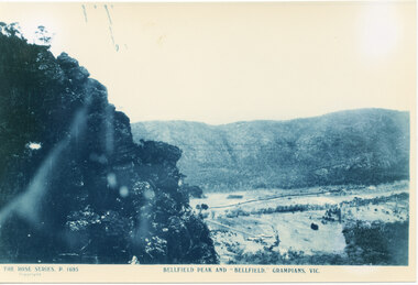
Photograph
... 117-119 Grampians Road Halls Gap grampians Photo is of Fyans ...Photo is of Fyans Valley with Hotel Bellfield in the valley. Photo is taken from Bellfield Peak. c1940sA rocky outcrop on far left of photo. a cleared valley with buildings and roads in foreground, flanked by a mountain range.THE ROSE SERIES. P 1695 BELLFIELD PEAK AND "BELLFIELD," GRAMPIANS, VIC scenery, fyans valley -
 Halls Gap & Grampians Historical Society
Photograph, C 1960s
... 117-119 Grampians Road Halls Gap grampians The valley is known ...The valley is known as Fyans Valley and the township of Halls Gap. Photo is typical of those taken by the Forestry Commission (Vic) during the 1960s.Photo shows two rocky outcrops in the foreground framing a valley in the distance below. A partial view of a mountain range flanks the valley. Plains of trees and open fields, and also a lake, can be seen beyond the mountain range. Within the valley in the middle of the photo buildings, roads and cleared land can be seen.scenery, fyans valley -
 Halls Gap & Grampians Historical Society
Photograph - B/W
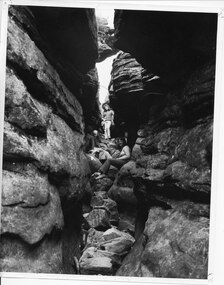
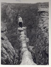
... 117-119 Grampians Road Halls Gap grampians the three women ...the three women appear to be in 'Silent Street', part of the Wonderland Range on the pathway to The Pinnacle lookout.3 young women sitting and standing amongst 2 rock cliffs with tumbled rocks that appear to form steps. a railing can be seen behind standing girl. Clothing is suggestive of the 1970s period.scenery, wonderland range -
 Halls Gap & Grampians Historical Society
Photograph - B/W
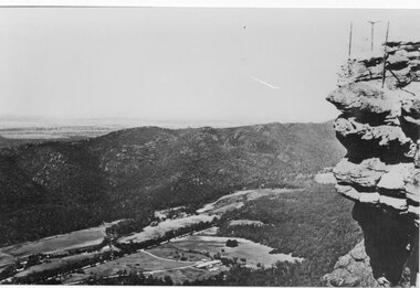
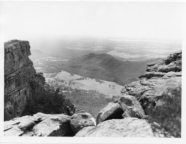
... 117-119 Grampians Road Halls Gap grampians The two men ...The two men are standing at The Pinnacle Lookout, overlooking Bellfield Reservoir in the Fyans ValleyTwo men standing behind cyclone wire three panel fence. Man on left is wearing a white shirt and long pants, the other in a checked shirt and long dark pants. They are on top of a large rocky outcrop overlooking a body of water and another mountain range scenery, lookouts -
 Halls Gap & Grampians Historical Society
Photograph
... 117-119 Grampians Road Halls Gap grampians Photo depicts Fyans ...Photo depicts Fyans Valley. The road is The Grampians/ Dunkeld Road, leading to Dunkeld towards the right or Halls Gap travelling towards the left. Fyans Creek is visible in parts at the foot of the range (middle of Photo). Photo appears to have been taken from Bellfield Pk area. Photo is typical of those taken by Forests Commission of Victoria in the 1960sPhoto shows a mountain range in the background with a valley. The Valley has a band of a mostly cleared grassy section (middle of photo) with a fairly dense treed area in the foreground. A road and some buildings can be seen where the cleared land meets the treed area.scenery, fyans valley -
 Halls Gap & Grampians Historical Society
Photograph - B/W
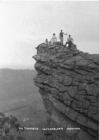
... 117-119 Grampians Road Halls Gap grampians Photograph is taken ...Photograph is taken at the Pinnacle in the Wonderland Range. The valley below is the Fyans Valley.Three men and a woman laying, sitting and standing on top of a high rocky outcrop. The woman and two men wear hats and the man standing is holding a stick. A mountain range can be seen opposite them with a valley far below, between the two ranges. A group of buildings can be seen in the valley. The style of dress worn by the people suggests early 1900s.The Pinnacle Wonderland Grampiansscenery, wonderland range -
 Halls Gap & Grampians Historical Society
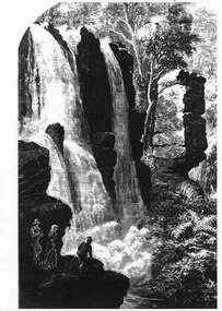
Photograph - Photocopy
... 117-119 Grampians Road Halls Gap grampians SCENERY Waterfalls ...large waterfall. In the front foreground on the left are three people, two men and a woman. One man rests against the rocks. A woman stands beside him looking towards the waterfall whilst the third man is kneeling, looking over the edge of the ledge on which they are standing, down towards the falling water. On the right hand side many ferns are growingscenery, waterfalls -
 Halls Gap & Grampians Historical Society
Photograph - B/W
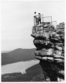
... 117-119 Grampians Road Halls Gap grampians Photo ...Photo is of the 'Nerve Test' and is a tourism promotion photo taken by the Victorian Railways. Photo shows woman standing at end of narrow ,rocky ledge. Large rock formations flank ledge on both sides. Woman is wearing black pants and a cardigan.scenery, wonderland range -
 Halls Gap & Grampians Historical Society... 117-119 Grampians Road Halls Gap grampians ...
 -
Halls Gap & Grampians Historical Society... 117-119 Grampians Road Halls Gap grampians ...
-
Halls Gap & Grampians Historical Society... 117-119 Grampians Road Halls Gap grampians ...
-
Halls Gap & Grampians Historical Society... 117-119 Grampians Road Halls Gap grampians ...
-
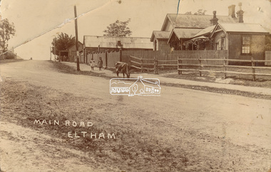 Eltham District Historical Society Inc
Photograph, J.H. Clark (poss), Main Road, Eltham, c.1910
Original photo from a scrapbook belonging to Heather Jenkins (nee Cone) who lived as a child in the Police Residence at 728 Main Road, Eltham from 1911 to the early 1920s. (Reported in Newsletter No. 98, Sept., 1994). View looking north up Policeman’s Hill across Main Road towards the Police Station, Police Residence and Courthouse, c.1910 prior to Brougham Street being made. The two rails / gap in the fence would be where Brougham Street now enters Main Road. Also visible are Knapman's Forge adjacent to Courthouse and E.J. Andrew's Store on top of the hill At the upper left can be seen the front of the Evelyn Hotel. On the opposite corner was Watsons Hotel. E.J. Andrew's store with its verandah was on the corner of Franklin Street. Behind the picket fence stands the 1860 Court House and Police residence with the weatherboard clad Police office. The enclosed fence is now the end of Brougham Street, opened to Bible Street in 1926. The Evelyn Hotel (formerly Fountain of Friendship) burnt down in the 1930s when it was being used as a boarding house since 1919. A cow is feeding on the grass verge in street. The photo is identified in white lettering typical of the style of Clark Bros., photographers of Windsor, Melbourne (1894-1914). One of the brothers, John Henry Clark, took many early photos around Little Eltham and moved to Eltham in 1916 where he lived at the bottom of the hill. Typically, he would add “J.H. Clark Photo” to his personal work, but this is not evident. There is however some ghost writing, a cheeky inscription in small white lettering in the grass verge in front of where Brougham Street is, which appears to state: “Heather or Hannah was here”. Perhaps J.H. Clark took the photo during a trip to Eltham and gifted it some years later after moving there as a gift to a young Heather Cone. The Police Station sign: E vii R ELTHAM POLICE STATION HEIDELBERG DISTRICT Edward VII ascended the throne in 1901 and died 6 May 1910. He was succeeded by George V.Heather Cone was the daughter of Constable John Thomas Cone (Badge 3935) the local police officer in residence at Eltham, 1 May 1911 to 9 July 1922. Heather McKnight Jenkins (nee Cone) was born 1911, possibly at the Eltham Police Residence and spent her childhood growing up in the Police Residence. Heather was the daughter of John Thomas Cone, Police Constable, and Charlotte Helena Cone (nee Black) who had married in 1906. Constable Cone was transferred to Eltham Police Station from Lauriston (near Kyneton) in May 1911. He retired from the force around September 1922 most likely as a result of significant health concerns experienced earlier that year from 22 April when he was hospitalised. He died 5 October 1922 at Maria Street at age 60 leaving behind a widow and two daughters; his son having pre-deceased him as a result of effects of the war. He is buried in Melbourne General Cemetery . In his probate it states that he owned a piece of land 200 links frontage to Maria Street and a depth of 241 links. It is believed that this is the land opposite the Police Station which Heather Jenkins referred to as being owned by her father and where he agisted the Police horses. Heather, her sister and mother Charlotte remained in Eltham until at least the 1924 Electoral Roll where Charlotte was listed as Home Duties however by 1925 she was listed at 229 Glenferrie Road, Malvern, occupation, Registrar of Births. In the 1934 (and 1936) Electoral Roll, Heather was a Clerk and her mother Charlotte was the Registrar of Births. in 1952 following her mother’s death she made application for Grant of Probate. Heather remains listed in the 1954 Electoral Roll at 13 Ashburton Road under her maiden name Cone however by the 1963 Electoral Roll she is listed at the same address as Heather McKnight Jenkins long with James Gardiner Jenkins. Neither appear listed in the 1958 Electoral Roll. James Gardiner Jenkins (1892-1975) first wife was Fanny Davison Carrucan (1899-1929), daughter of Denis Carrucan and Jane (nee McAleese). They married in 1925. Fanny died 11 November 1929. In the 1934 Electoral Roll he remained listed at John Street, Eltham, Railway Employee however by 1935 Electoral Roll, James Gardiner Jenkins, Railway Employee, was listed at 229 Glenferrie Road, Malvern and he remained living with Charlotte and Heather Cone when they moved to 13 Ashburton Road, Glen Iris. One of Constable Cone’s first investigations upon arriving in Eltham was the accidental fatal shooting in the head with a pea rifle by young Francis August Capewell, aged 11, of John Sutcliffe Deegan, 14, in Maria Street near the Railway. Constable Cone’s replacement was Constable William Charles Sargeant who commenced in charge of the Eltham Police Station from Thursday, 10 August 1922. Constable William Charles Sargeant, and his wife Elizabeth Agnes Sargeant were based at the Eltham Police Station until his transfer to the Police Station in Burwood Road, Hawthorn. He retired at Hawthorn Police Station in 1931, described by Hawthorn Council in 1927 as in a disgraceful condition and unfit for human habitation (Kathryn Griffin family tree – Ancestry) whereupon they moved to 28 Saunders Street, Coburg. Elizabeth died 16 July 1936 in Fitzroy. William then moved to 6 Queen Street Coburg in 1936 and then 1 Queen Street in 1942 where he died 7 August 1944. He is buried at Fawkner Cemetery.Sepia postcard photo glued on a brown paper scrapbook page (torn from scrapbook) along with 8 other black and white/sepia photos of varying sizes, 1 newspaper clipping and handwritten captions in ink.brougham street, constable w.c. sargeant, courthouse, cow, eltham, knapmans forge, little eltham, local history centre, main road, maria street, police residence, police station, policeman's hill, scrapbook, w.b. andrew corn store, j.h. clark photo, andrews store, heather jenkins (nee cone), clark bros. photo