Showing 937 items
matching heritage places
-
 Ballarat Heritage Services
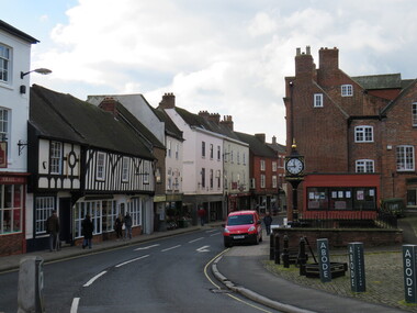
Digital Photograph, Ashbourne, UK
Ashbourne was the village of an historical event. At Ashbourne on 3 December 1745 Charles Edward Stuart declared his father James King of England, Wales and Scotland. Ashbourne is one of Derbyshire's fines and most vibrant market towns. It combines a wealth of historic buildings and shops. The Market Place is cobbles with hidden alleys and yards that lead to the carparks behind the main street. The wide and elegant Church Street is considered to be the finest street of Georgian buildings in Derbyshire. Tissington Hall and Village are in the nearby vicinity. Built by Francis Fitzherbert in 1609 Tissington Hall has been lived in by the Fitzherbert family ever since. The estate village has a number of micro businesses and a beautiful duck pond. Reference: Information from the Ashbourne Tourist pamphlet -
 Ballarat Heritage Services
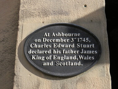
Digital Photograph, Plaque, Ashbourne, UK
Ashbourne is one of Derbyshire's fines and most vibrant market towns. It combines a wealth of historic buildings and shops. The Market Place is cobbles with hidden alleys and yards that lead to the carparks behind the main street. The wide and elegant Church Street is considered to be the finest street of Georgian buildings in Derbyshire. Tissington Hall and Village are in the nearby vicinity. Built by Francis Fitzherbert in 1609 Tissington Hall has been lived in by the Fitzherbert family ever since. The estate village has a number of micro businesses and a beautiful duck pond. Reference: Information from the Ashbourne Tourist pamphletAt Ashbourne on December 3rd 1745, Charles Edward Stuart declared his father James King of England, Wales and Scotland.king james, ashbourne -
 Ballarat Heritage Services
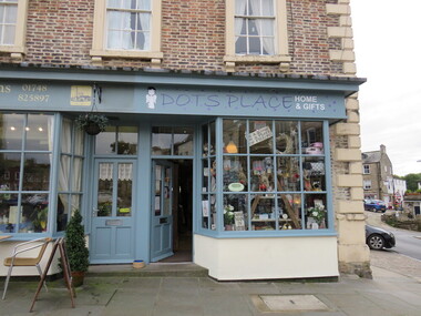
Digital Photograph, Dot's Place, Richmond, UK
-
 Ballarat Heritage Services
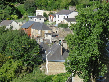
Digital Photograph, Dorothy Wickham, Vire, Normandie, France, 10/2016
The town of Vire is on a rocky promontory above the Vire River, situated in the south-west of the Calvados department of Lower Normandy, about half way between Caen (north-east of Vire) and Mont-Saint-Michel (to the south-west). Since 2016 the town has been part of the commune called Vire-Normandie. The town suffered quite heavily during bombardments at the end of the Second World War, and much reconstruction and renovation took place in the decade that followed the end of the war. (https://www.francethisway.com/places/vire.php) Julien Hardy, a stonemason and first discoverer of gold at Happy Valley, near Ballarat, Victoria Australia, was born near Vire, France. This photograph was taken by a descendant of Julian Hardy.Two colour photographs of buildings in the town of Vire, Normandie, France.julien hardy, vire, normandy -
 Ballarat Heritage Services
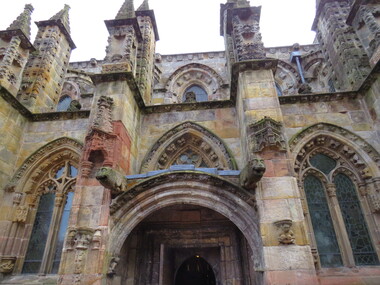
Digital Photograph, Rosslyn Chapel (detail), 10/2016
Sir William St Clair founded Rosslyn Chapel in 1446. It is located south of Edinburgh, Scotland. St Clair hoped to spread intellectual and spiritual knowledge and to ensure his place in Heaven. Rosslyn Chapel is a fine example of stonemason's work. It has many atropaic marks and mason's marks with other symbolism adorning it's structure as well. Excavations in the 1800s uncovered further foundations and building but Sir William died and the larger building was never completed. The village of Roslin (differing spelling) grew up around the estate and chapel due to the large number of craftsmen who helped build it over a 40 year period. William St Clair was the 3rd Prince of Orkney. He died in 1484. His name and the names of his descendants are linked to the beginnings of freemasonry in Scotland. Sir William Sinclair of Rosslyn was granted charters from the Masons of Scotland in 1630.The author Dan Brown who published the Da Vinci Code in 2003 is responsible for the upsurge in interest and visitors at the centre. The Visitor's centre was officially opened in 2012. Colour photographs showing Rosslyn Chapel.rosslyn chapel william st clair freemasonry freemasons scotland -
 Whitehorse Historical Society Inc.
Article, Out There, 05/05/1995
A 1995 newspaper article mentioning Schwerkolt Cottage as an interesting place to visitnon-fictionA 1995 newspaper article mentioning Schwerkolt Cottage as an interesting place to visitschwerkolt cottage & museum complex, heritage buildings -
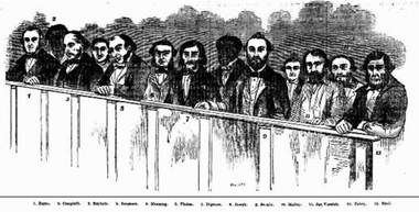
 Ballarat Heritage Services
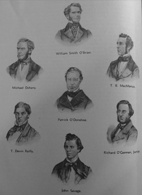
Image, Members of Young Ireland
The Young Irelander Rebellion was a failed Irish nationalist uprising led by the Young Ireland movement, part of the wider Revolutions of 1848 that affected most of Europe. It took place on 29 July 1848 in the village of Ballingarry, South Tipperary. After being chased by a force of Young Irelanders and their supporters, an Irish Constabulary unit took refuge in a house and held those inside as hostages. A several-hour gunfight followed, but the rebels fled after a large group of police reinforcements arrived. It is sometimes called the Famine Rebellion (since it took place during the Great Irish Famine) or the Battle of Ballingarry. (wikipedia)Image of seven men associated with the Young Ireland Movement.young ireland, william smith o'brien, michael doheny, t.b. macmanus, patrick o'donohue, richard o'gorman junior, john savage -
 Ballarat Heritage Services
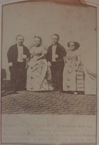
Photograph - Photograph - Black and White, Theatrical Troup, c1865
Tom Thumb and Lady were performers in P.T. Barnum’s circus. Once they became engaged, the public developed a fascination for them—nicknaming them the “little couple.” Barnum used their engagement to publicize his show, parading the couple around to different nations’ leaders and placing newspaper announcements detailing their upcoming wedding ceremony. On their wedding day in New York City, over 2,000 people entered the church to watch the couple say their vows. Fellow performers Minnie Warren (the bride’s younger sister) and “Commodore Nutt” (George Washington Morrison Nutt) served as the maid of honor and best man.Photographic tintype portrait of a child.General Tom Thumb and Wife, Commodore Nutt and Miss Minnie Warren, In the indentical costumes worn before Her Majesty Queen Victoria at Windsor Castle, June 1865.fullarton, tom thumb, theatre, commodore nutt, minnie warren, queen victoria -
 Ballarat Heritage Services
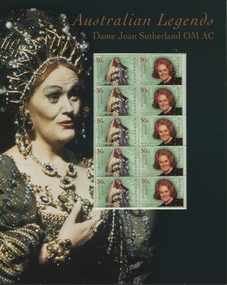
Stamps, Joan Sutherland stamps issue, 2004
A Golden Celebration A Gala Tribute to Dame Joan Sutherland and Mr Richard Bonynge was held at Opera Theatre Sydney Opera House on Thursday 22 January 2004. The major patron was Australia Post who issued stamps with Joan Sutherland's image on them. Many singers took part in the Celebration Concert, including Jacqueline Dark and David Hobson both born in Ballarat. Issue of stamps in place in A4 presentation cardboard with image of Dame Joan Sutherland in costumejoan sutherland, stamps, richard bonyngne, jacqueline dark, david hobson, opera, a golden celebration -
 Ballarat Heritage Services
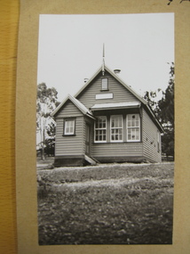
Photograph - digital copy, Yandoit School, 23 Nov 2012
Yandoit was a location near Daylesford, known as a place where many Italians settled during the Victorian gold rushes of the 1850s.Early photographs of Yandoit School.yandoit, education -
 Ballarat Heritage Services
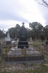
Photograph - Colour, Clare Gervasoni, Sandon Cemetery, 2017, 16/07/2017
The headstone is made of Italian marble, and the stonemason was H.A. Place, Daylesford. Luigi Gervasoni was from San Gallo, Bergamo, Lombardy, Italy, and arrived in Australia in 1863. In loving memory of Luigi Paolo Gervasoni Dearly loved husband of Eliza A. Gervasoni who died April 11th 1908 aged 65 years also Eliza A. Gervasoni who died Jany 29th 1912 aged 56 years and Louis Joseph Gervasoni Died March 22nd 1947 Aged 72 years.sandon, sandon cemetery, yandoit creek, luigi gervasoni, eliza gervasoni, louis joseph gervasoni, h.a. place -
 Ballarat Heritage Services
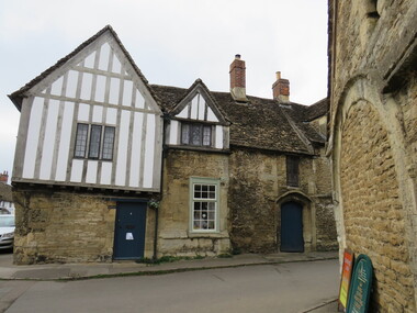
Photograph - Photograph - Colour, Lacock Village, England
Lacock Village, England, was the place that Harry Potter was filmed. stonework, england, lacock village -
 Ballarat Heritage Services
Photograph - Photograph - Colour, Lacock Village, England
Lacock Village, England, was the place that Harry Potter was filmed. lacock village, england, stonework, harry potter, england, yellow flowers -
 Ballarat Heritage Services
Photograph - Colour, Lacock Village, England
Lacock Village, England, was the place that Harry Potter was filmed. lacock village, england, stonework -
 Ballarat Heritage Services
Photograph - Colour, Lacock Village, England
Lacock Village, England, was the place that Harry Potter was filmed. lacock village, england, stonework -
 Ballarat Heritage Services
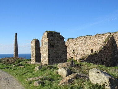
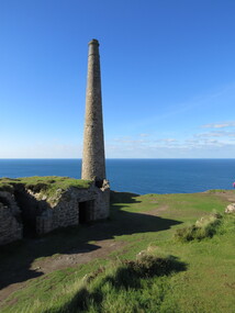
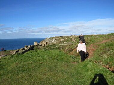
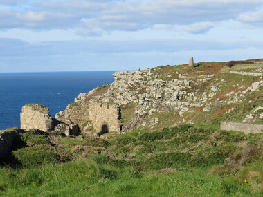
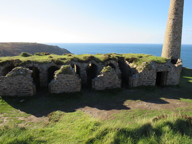
Photograph - Colour, Dorothy Wickham, St Just, Cronwall, World Heritage Site
... , a medieval grassed amphitheatre – the Plen an Gwary or ‘playing place ...A stone’s throw from Land’s End, this is the most westerly Area of the Site. St Just is characterised by big skies, jagged rocks, stark moorland, and iconic clifftop engine houses perched above the Atlantic in some incredible locations. No wonder this dramatic setting has inspired generations of artists, writers and photographers. World-famous for their mineralogy, the mining sites here are extremely well preserved – as is the sense of community amongst the people whose lives they once dominated. This Area’s unique geography and mineralogy meant that undersea mining was more concentrated here than anywhere else in the world in the 18th and 19th centuries. The oldest surviving Cornish beam engine (constructed in 1840) remains in its original engine house at Levant, restored and still working under steam. Geevor, one of the last mines to close in Cornwall (1990), was saved from demolition and is now the largest metalliferous mine site open to the public in the UK. The historic mining town of St Just is home to characteristic rows of granite mine workers’ cottages, public squares, shops, cafés, art galleries and, just off Bank Square, a medieval grassed amphitheatre – the Plen an Gwary or ‘playing place’.st just, world heritage, ellis, penrose, cornwall, mining, mines -
 Ballarat Heritage Services
Photograph - Colour, Dorothy Wickham, St Just, Cornwall, World Heritage Site
... , a medieval grassed amphitheatre – the Plen an Gwary or ‘playing place ...A stone’s throw from Land’s End, this is the most westerly Area of the Site. St Just is characterised by big skies, jagged rocks, stark moorland, and iconic clifftop engine houses perched above the Atlantic in some incredible locations. No wonder this dramatic setting has inspired generations of artists, writers and photographers. World-famous for their mineralogy, the mining sites here are extremely well preserved – as is the sense of community amongst the people whose lives they once dominated. This Area’s unique geography and mineralogy meant that undersea mining was more concentrated here than anywhere else in the world in the 18th and 19th centuries. The oldest surviving Cornish beam engine (constructed in 1840) remains in its original engine house at Levant, restored and still working under steam. Geevor, one of the last mines to close in Cornwall (1990), was saved from demolition and is now the largest metalliferous mine site open to the public in the UK. The historic mining town of St Just is home to characteristic rows of granite mine workers’ cottages, public squares, shops, cafés, art galleries and, just off Bank Square, a medieval grassed amphitheatre – the Plen an Gwary or ‘playing place’.st just, world heritage,, ellis,, penrose, cornwall, mining, mines -
 Ballarat Heritage Services
Photograph - Colour, Dorothy Wickham, St Just, Cornwall, World Heritage Site
... , a medieval grassed amphitheatre – the Plen an Gwary or ‘playing place ...A stone’s throw from Land’s End, this is the most westerly Area of the Site. St Just is characterised by big skies, jagged rocks, stark moorland, and iconic clifftop engine houses perched above the Atlantic in some incredible locations. No wonder this dramatic setting has inspired generations of artists, writers and photographers. World-famous for their mineralogy, the mining sites here are extremely well preserved – as is the sense of community amongst the people whose lives they once dominated. This Area’s unique geography and mineralogy meant that undersea mining was more concentrated here than anywhere else in the world in the 18th and 19th centuries. The oldest surviving Cornish beam engine (constructed in 1840) remains in its original engine house at Levant, restored and still working under steam. Geevor, one of the last mines to close in Cornwall (1990), was saved from demolition and is now the largest metalliferous mine site open to the public in the UK. The historic mining town of St Just is home to characteristic rows of granite mine workers’ cottages, public squares, shops, cafés, art galleries and, just off Bank Square, a medieval grassed amphitheatre – the Plen an Gwary or ‘playing place’.st just, world heritage, ellis, penrose, cornwall, mining, mines -
 Ballarat Heritage Services
Photograph - Colour, Dorothy Wickham, St Just, Cronwall, World Heritage Site
... , a medieval grassed amphitheatre – the Plen an Gwary or ‘playing place ...A stone’s throw from Land’s End, this is the most westerly Area of the Site. St Just is characterised by big skies, jagged rocks, stark moorland, and iconic clifftop engine houses perched above the Atlantic in some incredible locations. No wonder this dramatic setting has inspired generations of artists, writers and photographers. World-famous for their mineralogy, the mining sites here are extremely well preserved – as is the sense of community amongst the people whose lives they once dominated. This Area’s unique geography and mineralogy meant that undersea mining was more concentrated here than anywhere else in the world in the 18th and 19th centuries. The oldest surviving Cornish beam engine (constructed in 1840) remains in its original engine house at Levant, restored and still working under steam. Geevor, one of the last mines to close in Cornwall (1990), was saved from demolition and is now the largest metalliferous mine site open to the public in the UK. The historic mining town of St Just is home to characteristic rows of granite mine workers’ cottages, public squares, shops, cafés, art galleries and, just off Bank Square, a medieval grassed amphitheatre – the Plen an Gwary or ‘playing place’.st just, world heritage, ellis, penrose, cornwall, mining, mines -
 Ballarat Heritage Services
Photograph - Colour, Dorothy Wickham, St Just, Cornwall, World Heritage Site
... , a medieval grassed amphitheatre – the Plen an Gwary or ‘playing place ...A stone’s throw from Land’s End, this is the most westerly Area of the Site. St Just is characterised by big skies, jagged rocks, stark moorland, and iconic clifftop engine houses perched above the Atlantic in some incredible locations. No wonder this dramatic setting has inspired generations of artists, writers and photographers. World-famous for their mineralogy, the mining sites here are extremely well preserved – as is the sense of community amongst the people whose lives they once dominated. This Area’s unique geography and mineralogy meant that undersea mining was more concentrated here than anywhere else in the world in the 18th and 19th centuries. The oldest surviving Cornish beam engine (constructed in 1840) remains in its original engine house at Levant, restored and still working under steam. Geevor, one of the last mines to close in Cornwall (1990), was saved from demolition and is now the largest metalliferous mine site open to the public in the UK. The historic mining town of St Just is home to characteristic rows of granite mine workers’ cottages, public squares, shops, cafés, art galleries and, just off Bank Square, a medieval grassed amphitheatre – the Plen an Gwary or ‘playing place’.st just, world heritage, ellis, penrose, cornwall, mining, mines -
 Ballarat Heritage Services
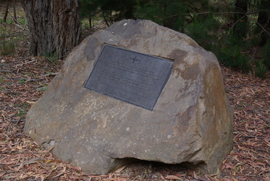
Photograph - Photograph - Colour Digital, Ballarat Reform League Inc Monument at Buninyong, 12/11/2012
Before the end of August 1851 the government had decided to charge a large licence fee for the right to search for gold. When news of that decision reached the Buninyong diggings, the first protest on the Victorian goldfields was held. The monument to that meeting has been placed at the site where it is believed that the meeting took place, in Hiscock Gully Road, about 400 metres from the Midland Highway.Colour photograph of a rock with a commemorative plaque outlining goldfields agitation at Buninyong.The plaque on the monument reads:- "Plaque on the Ballarat Reform League Inc. Monument at Buninyong, 2012. After the discovery of gold at Buninyong in August 1851 the government announced that the diggers would be charged a large licence fee. The injustice of that decision sparked a public protest here at the diggings. 'Buninyong 26 August - Tonight for the first time since Australia rose from the bossum of the ocean, were men strong in their sense of right, lifting up a protest against an impending wrong, and protesting against the Government. (Melbourne Argus, 20 August 1851)"ballarat reform league inc, goldfields agitation, buninyong monument, eureka stockade -
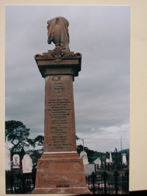
 Ballarat Heritage Services
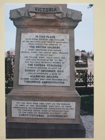
Photograph - Colour, Diggers' Monument Inscription, Ballaarat Old Cemetery, 2004, 04/08/2019
The Eureka Stockade took place at Eureka (Ballarat East) on 03 December 1854.Colour photographs of the inscription on the Diggers Grave at the Ballaarat Old Cemetery.eureka stockade, eureka diggers monument, ballaarat old cemetery, gravestone, memorial -
 Ballarat Heritage Services
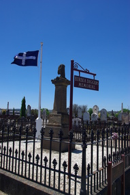
Photograph - Photograph - Colour, Clare Gervasoni, Diggers' Memorial, Ballaarat Old Cemetery, 2013, 30/11/2013
The Eureka Stockade took place at Eureka (Ballarat East) on 03 December 1854.Colour photographs of the Diggers Grave at the Ballaarat Old Cemetery. The Eureka Flag is fluingeureka diggers monument, ballaarat old cemetery, gravestone, memorial -
 Ballarat Heritage Services
Photograph - Colour, Wayne Phillipson, Diggers' Monument Inscription, Ballaarat Old Cemetery, 2004, 04/18/2004
The Eureka Stockade took place at Eureka (Ballarat East) on 03 December 1854.Colour photographs of the Diggers Grave at the Ballaarat Old Cemetery.eureka stockade, eureka diggers monument, ballaarat old cemetery, gravestone, memorial -
 Ballarat Heritage Services
Newspaper - Image, State Teason Trials, 1855, 02/03/1855
The State Treason Trials took place after the Eureka Stockade.State Treason trials prisoners as depicted in the Mount Alexander Mail. eureka stockade, state treason trials, raffaello carboni, timothy hayes, john joseph -
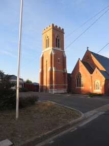 Ballarat Heritage Services
Photograph - Colour, Site of the Bakery Hill Monster Meeting, 2016, 03/12/2016
Flag pole behind St Paul's Anglican Church. It was on the brow of this hill that the Bakery Hill Monster Meetings took place in the prelude to the Eureka Stocade.st paul's anglican church, bakery hill, bakery hill monster meeting, eureka stockade, eureka flag -
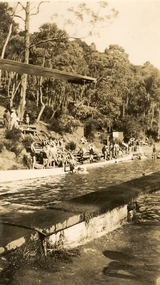 Ballarat Heritage Services
Photograph - Photograph - Black and White, Hepburn Springs Swimming Pool
The Hepburn Pool was built in Spring Creek during the 1930s by the Zelmans of Bellinzona Guest House. Alberto Zelman paid for local workers to construct the pool to their specifications so the visitors to local guest houses could swim on hot days. The Hepburn Pool was used for the Victorian Swimming Championships, with 6 stones marked at one end for each lane. It is 50 yards long, the length required for competitions. In 1935 the Hepburn Amateur Swimming Club organised their first swimming carnival, the meeting conducted by the Victorian Amateur Swimming Association, In 1969 the Daylesford Olympic Swimming Pool was constructed so this 'old swimming pool' was neglected. Fortunately in 1993 local volunteers associated with the Savoia Hotel returned the pool to its former glory with the help of old photos and a lot of hard work. Two well known swimmers swam at the pool in the Victorian swimming Championships, they were Annette Kellerman and Frank Beaurepaire. The Pool was named Victoria's Favourite Built Place in 2004 as part of the Victorian Government's involvement in the International Year of the Built Environment. It was included on the Victorian Heritage Register following a nomination and comparative analysis of pre Olympic Swimming Pools in Victoria by Lisa Gervasoni.Black and white photograph of the Hepburn Pool in Spring Creek, including the diving board.hepburn springs swimming pool, hepburn springs, hepburn pool, pre-olympic swimming pools, albert zelman, bellinzona, annette kellerman, frank beaurepaire, victorian amateur swimming association, hepburn amateur swimming club -
 Ballarat Heritage Services
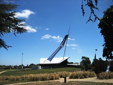
Photograph - Photograph - Colour, Clare Gervasoni, Eureka Stockade Centre, 2008, 14/02/2008
Colour photograph of the Eureka Stockade Centre with the Eureka Sail in place.eureka stockade centre, eureka sail, eureka stockade gardens -
 Lakes Entrance Regional Historical Society (operating as Lakes Entrance History Centre & Museum)
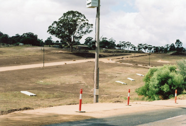
Photograph, Holding M, 2006
Property and subdivision believed to have been done by Bill and Kaye Reddenbach.Colour photograph of early stage of residential development showing roadways formed through property, drainage pipes placed ready for installation, street lighting in place. Photograph taken from school, looking east. Swan Reach Victoriahouses, heritage study