Showing 6584 items matching "housing"
-
 Kiewa Valley Historical Society
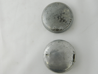
Ash Tray Pocket
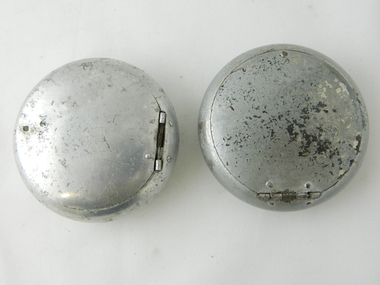
... The opening lid is spring loaded, hinged top, circular and fixed by a clasp, pop- riveted (4) onto the main housing. Opposite the hinge the lid is held closed by a small metal ball fitting tightly to the top wall of the container. ...The opening lid is spring loaded, hinged top, circular and fixed by a clasp, pop- riveted (4) onto the main housing. Opposite the hinge the lid is held closed by a small metal ball fitting tightly to the top wall of the container. ...This flip top pocket aluminium ash tray was at the beginning of the social "cleaning up" of cigarette ash and related products. This cigarette waste container was for those occasions when it was polite not to throw the cigarette ash and used up cigarettes "buts" on the ground, or if working in any rural area during a dry fire prone season, when discarding burning cigarette waste could set up a severe "bush" fire. It was also at the beginning of an intensive look at the affects of smoking upon the health of users. Later in the 1900s was a time when medical evidence supported a ground swell of the anti smoking movement which resulted in further restrictions of the use cigarette smoking in public places. Before the anti cigarette smoking revolution, it was both fashionable and manly to either roll your own cigarette or open up a packet of "tailor made's". In the rural and man's man environment the roll your own provided a visual acknowledgement that the user was "true blue" Aussie male and not a city boy. The cycle of use of cigarettes has drastically changed from when this item was first used. Today's society (post 2000) has produced a ground swell of government and non government organisations whose aim is provide a cigarette "ash" free environment and society. This is highlighted in the beginning of the 2000 millennium by a cigarette "Free" Australia campaign, and the pocket flip top personal ash tray as a practical solution for butt litter disposal.This light weight aluminium pocket ash tray not only was used when social graces required it to, but also provided a container for any unfinished cigarettes or stogies (cheap half used cigars). In rural areas (open fresh air countryside), where time was always made available for the "smoko" (Australian rest period), at any time, especially after some hard physical work, the ability to have a self contained ashing apparatus, not to offend the gentler folk, was a pre-requisite . The rural environment, in the days of these cigarette ash containers,was one which could range from harsh and unforgiving to mild and relaxing. Smoking could be enjoyed anywhere and at any time without too much "fussing" around. This ash tray was mobile, convenient, unobtrusive and regarded by the user as being considerate to those around. It also eliminated the tell tale evidence that the "no smoking" signs had been ignored. The Kiewa Valley was like many rural ares that found it hard for smokers to come to grips with a governmental "non smoking policy" to indoor recreational and other "confined space" environments. The covered lid reduces odors and eliminates ashes from being blown around.Aluminium round container with a lid. The opening lid is spring loaded, hinged top, circular and fixed by a clasp, pop- riveted (4) onto the main housing. Opposite the hinge the lid is held closed by a small metal ball fitting tightly to the top wall of the container. The lid is opened by the use of a fingernail positioned at junction of lid to body. This edge is bevelled to allow access.personal effects, tobacco waste products, smoking accessories, tobacco -
 Bendigo Historical Society Inc.
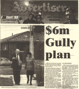
Document - LONG GULLY HISTORY GROUP COLLECTION: $6M GULLY PLAN
... It has a photo of Ron Best MLC and Housing Minister Ann Henderson on a tour of Long Gully. ...It has a photo of Ron Best MLC and Housing Minister Ann Henderson on a tour of Long Gully. ...BHS CollectionPhotocopy of the front page of the Bendigo Advertiser Friday August 20, 1999. The article titled $6m Gully plan by Linda Barrow mentions a building plan for the area. It has a photo of Ron Best MLC and Housing Minister Ann Henderson on a tour of Long Gully. There is a small article about Phil White, The Herald Sun/Monash University Teacher of the Year Award.bendigo, history, long gully history group, the long gully history group - $6m gully plan, bendigo advertiser20/8/1999, ron best, ann henderson, jacquelene hunt, phil white, golden square secondary college, herald sun, monash university, graeme fryar, racv, ashmans, linda barrow -
 Port Melbourne Historical & Preservation Society
Film - CD-ROM, PMHPS Meeting, Presentation, Gems found at the Public Records Office Victoria, Steve Tserkezidis, 26 Jan 2015
... Principally containing images and plans involving State Bank housing estates at Garden City, Fishermen's bend and the Dunstan estate. ...Principally containing images and plans involving State Bank housing estates at Garden City, Fishermen's bend and the Dunstan estate. ...PMHPS meeting 26.01.2015 Powerpoint presentation by Steve Tserkezidis on "gems found at the Public Records Office Victoria". Principally containing images and plans involving State Bank housing estates at Garden City, Fishermen's bend and the Dunstan estate. Images of the State Savings Bank building and Riall print have been separately extracted and entered on the database as cat nos 3468 to 3471 built environment - domestic, built environment - commercial, steve tserkezidis, state savings bank of victoria -
Port Melbourne Historical & Preservation Society
Book - Port Melbourne Council, Sanitary Inspectors Report Book, J L Cousland, Inspector et al, 1944 - 1955
... Detailing testing and immunisation programmes, mass x-ray, vaccination for smallpox, cleansing station opened, poor conditions in emergency housing areas, Lands Dept neglect of Crown land, rubbish dumped in air raid shelters, advice sought re football and cricket played on streets, wood for pensioners...Detailing testing and immunisation programmes, mass x-ray, vaccination for smallpox, cleansing station opened, poor conditions in emergency housing areas, Lands Dept neglect of Crown land, rubbish dumped in air raid shelters, advice sought re football and cricket played on streets, wood for pensioners Book Port Melbourne Council, Sanitary Inspectors Report Book J L Cousland, Inspector B E W Aitken, Health Inspector ...Sanitary Inspector's Reports to Port Melbourne Council 1944-1955. Detailing testing and immunisation programmes, mass x-ray, vaccination for smallpox, cleansing station opened, poor conditions in emergency housing areas, Lands Dept neglect of Crown land, rubbish dumped in air raid shelters, advice sought re football and cricket played on streets, wood for pensionersLabel on spine illegible; 'Inspectors reports' inside covertransport - motor vehicles, local government - city of port melbourne, environmental issues, health - general health, business and traders, industry, nightsoil, built environment, fishermans bend, livestock, engineering - canals and drainage, james llewellyn cousland, b e w aitken, harley grover, dr merrilees, mr hepburn -
 Bendigo Historical Society Inc.
Document - NORMAN OLIVER COLLECTION: THE MAYOR SPEAKS 5 JUNE 1965
... Topics include: the Bendigo East Charity Club, the visit of Mr Tan Hoo Fong from Indonesia, and the housing problem in Bendigo and its effect on industrial development,...Topics include: the Bendigo East Charity Club, the visit of Mr Tan Hoo Fong from Indonesia, and the housing problem in Bendigo and its effect on industrial development, Document NORMAN OLIVER COLLECTION: THE MAYOR SPEAKS 5 JUNE 1965 ...The Norman Oliver collection. Norman Oliver was three times Mayor of Bendigo - 1950-51, 1964-65, 1970-71. Three pages of typed notes titled 'The Mayor Speaks June 5th 1965. Topics include: the Bendigo East Charity Club, the visit of Mr Tan Hoo Fong from Indonesia, and the housing problem in Bendigo and its effect on industrial development,bendigo, council, report, norman joseph oliver , councillor norman oliver. mayor of bendigo. bendigo east charity club. -
 Ringwood and District Historical Society
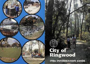
Booklet, City of Ringwood 1986 Information Guide, 1986
... Cover photographs: Front - Wombalano Park; Back L-R - Barbecue at Ringwood Lake, Housing construction at Ringwood, Enclosing swimming centre, Water cascade at rear of Ringwood Lake, Croquet at Jubilee Park, Playground at Ringwood Lake....Cover photographs: Front - Wombalano Park; Back L-R - Barbecue at Ringwood Lake, Housing construction at Ringwood, Enclosing swimming centre, Water cascade at rear of Ringwood Lake, Croquet at Jubilee Park, Playground at Ringwood Lake. ...Community information booklet issued by City of Ringwood for 1986 - covering the facilities and activities of the Ringwood Council and other local organisations and associations. Cover photographs: Front - Wombalano Park; Back L-R - Barbecue at Ringwood Lake, Housing construction at Ringwood, Enclosing swimming centre, Water cascade at rear of Ringwood Lake, Croquet at Jubilee Park, Playground at Ringwood Lake.CONTENTS: (page no.) After School Care Programme 30 & 31 Amalgamations 16 Aquatic Centre 14 & 15 Building Information 22 By-Law and Traffic Regulations 23 Chief Executive Message I0 Churches 38 Civic Centre 4 Committees of Council 5 Community Plan 12 & 13 Construction Work 34 Council Meeting Dates 4 Council Representatives 8 Councillors 6 & 7 Disabled Persons Facilities 41 Eastern Corridor Road Action Plan 17 Emergency Telephone Nos. 63 European Wasps 27 Family Day Care 30 Finances 18 Golf Course 22 Health 20 Historical Research Group 44 Home Help 33 Hospitals 45 Immunisations 2 i Incinerators 34 Infant Welfare Centres 45 Knaith Road Child Care Centre 30&31 Library 24 Local Area Traffic Management 17 Management Executive 11 Mayoral Message – Cr. W.R. (Bill) Wilkins, J.P. 3 Meals on Wheels 32 Members of Parliament 9 North Ringwood Senior Citizens 29 Parks for People 28 Playgroups 49 Pre-Schools 50 Rates 19 Rubbish — See Waste Ringwood District Centre 16 Schools 52 Swimming Pool — See Aquatic Centre 14 & 15 Waste 26rinx -
 Glenelg Shire Council Cultural Collection
Photograph - Photograph - Portland Lifeboat Going to the Rescue, Kodac, n.d
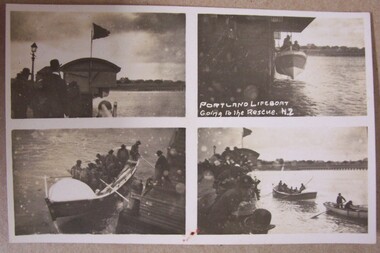
... Small series of 4 photos - Width is 13.4cm 1. Shows building housing lifeboat. Flag flying. Group of people. ...To Jean with love Uncle Will Small series of 4 photos - Width is 13.4cm 1. Shows building housing lifeboat. Flag flying. Group of people. ...Displayed at History House.Small series of 4 photos - Width is 13.4cm 1. Shows building housing lifeboat. Flag flying. Group of people. Gas lamp. 2. Lifeboat being lowered - Crew on board. 3. Lifeboat in water - men wearing life jacket - using oars to push off - man on pier. 4. Lifeboat and 1 other boat under way. Crown on pier.Front: Portland Lifeboat. Going to the Rescue (NZ) ??? Back: Postcard. To Jean with love Uncle Will -
 Tennis Australia
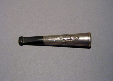
Smoking accessory, Circa 1915
... (2/2) Custom case for housing part 1; made of wood, leather and lined with velvet and cloth. ...No makers marks. (2/2) Custom case for housing part 1; made of wood, leather and lined with velvet and cloth. ...(1/2) A silver & amber cigaretter holder (Austrian), with relief of scene on silver section depicting a male figure holding a tennis racquet. No makers marks. (2/2) Custom case for housing part 1; made of wood, leather and lined with velvet and cloth. Printed in gold ink on cloth inside lid: 'ECHT SILBER & BERNSTEIN'. Materials: Silver/Metal, Ambertennis -
 B-24 Liberator Memorial Restoration Australia Inc
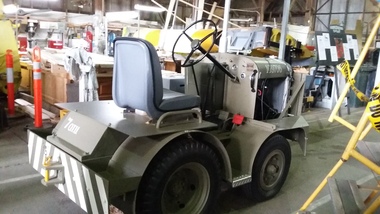
Vehicle, Mercury Aircraft Tug
... Tyre Pressure LBS.Per Sq Inch - Front 70 Rear 45 ON plate on Dashboard MORRIS COMMERCIAL embossed on gearbox housing. MT & T embossed on either side of radiator....Tyre Pressure LBS.Per Sq Inch - Front 70 Rear 45 ON plate on Dashboard MORRIS COMMERCIAL embossed on gearbox housing. MT & T embossed on either side of radiator. ...Motorised tugs were used by ground crew to move aircraft on the ground.This tug is of historical significance to the B24-LiberatorMotorised Aircraft TugMERCURY TRUCK & TRACTOR CO LTD GLOUCESTER ENGLAND-Embossed figurehead of Mercury on front. The MERCURY TRUCK & TRACTOR CO GLOUCESTER , For Spare parts quote chassis no.4962. Tyre Pressure LBS.Per Sq Inch - Front 70 Rear 45 ON plate on Dashboard MORRIS COMMERCIAL embossed on gearbox housing. MT & T embossed on either side of radiator. -
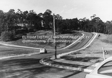
 Eltham District Historical Society Inc
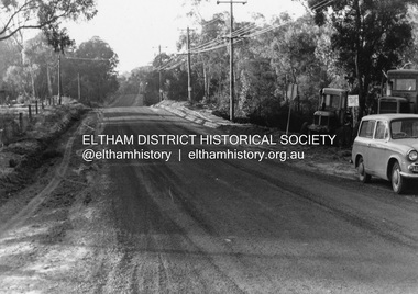
Photograph, R.J. Manuell, Briar Hill, c.1964
... View of Squires land which was subdivided for housing - two parts Woodland Crest higher part off Woodland Grove and Calrossi Avenue, Briar Hill showing new roads with curb and channelling and footpaths. ...Eltham District Historical Society Inc 728 Main Rd Eltham melbourne View of Squires land which was subdivided for housing - two parts Woodland Crest higher part off Woodland Grove and Calrossi Avenue, Briar Hill showing new roads with curb and channelling and footpaths. ...View of Squires land which was subdivided for housing - two parts Woodland Crest higher part off Woodland Grove and Calrossi Avenue, Briar Hill showing new roads with curb and channelling and footpaths. No date.Black and white photograph printed with white bordersVerso: COO2briar hill, real estate, woodland grove, squires, roads -
 Eltham District Historical Society Inc
Photograph, R.J. Manuell, Briar Hill, c.1964
... View of Squires land which was subdivided for housing - two parts Woodland Crest higher part off Woodland Grove and Calrossi Avenue, Briar Hill showing new roads with curb and channelling and footpaths. ...Eltham District Historical Society Inc 728 Main Rd Eltham melbourne View of Squires land which was subdivided for housing - two parts Woodland Crest higher part off Woodland Grove and Calrossi Avenue, Briar Hill showing new roads with curb and channelling and footpaths. ...View of Squires land which was subdivided for housing - two parts Woodland Crest higher part off Woodland Grove and Calrossi Avenue, Briar Hill showing new roads with curb and channelling and footpaths. No date.Black and white photograph printed with white bordersVerso: COO2briar hill, real estate, woodland grove, squires, roads -
 Port Melbourne Historical & Preservation Society
Photograph - Original gate post, Excelsior Hall, Port Melbourne, Gary Spivak, 2000
... Taken by Gary Spivak, an officer of the City of Port Phillip involved with the reconstruction of heritage buildings to create low cost housing. this project was under his direction. ...Port Melbourne Historical & Preservation Society Port Melbourne Town Hall 333 Bay Street Port Melbourne melbourne Taken by Gary Spivak, an officer of the City of Port Phillip involved with the reconstruction of heritage buildings to create low cost housing. this project was under his direction. ...Taken by Gary Spivak, an officer of the City of Port Phillip involved with the reconstruction of heritage buildings to create low cost housing. this project was under his direction. This gatepost was preserved in the reconstruction, one of the few portions that were.B&W photos of Excelsior Hall 2003, prior to redevelopment into units 07 - Original gate postbuilt environment - civic, town planning, heritage, excelsior hall, rsl, returned services league -
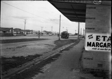 Ballarat Tramway Museum
Negative - SECV Ballarat 32 at Sebastopol terminus, Hugh Ballment, mid 1950s
... Photo shows Ballarat No. 32 at the Sebastopol terminus, possibly at the same time as item 10338, with the then relatively new Housing Commission homes, the terminus and a shop selling ETA margarine - see reference. ...Ballarat Tramway Museum South Gardens Reserve Wendouree Parade Ballarat Ballarat goldfields Photo shows Ballarat No. 32 at the Sebastopol terminus, possibly at the same time as item 10338, with the then relatively new Housing Commission homes, the terminus and a shop selling ETA margarine - see reference. ...Photo shows Ballarat No. 32 at the Sebastopol terminus, possibly at the same time as item 10338, with the then relatively new Housing Commission homes, the terminus and a shop selling ETA margarine - see reference. Photo mid 1950s.Yields information about the Sebastopol tram terminus and a nearby milk bar/grocery shop.Negative - 127 film black and whitetramways, tramcars, tram 32, sebastopol -
Port Melbourne Historical & Preservation Society
Newspaper, Rebel estate resident faces eviction, c.2024
... It was ruled that resident, Margaret KELLY, would be forcibly removed from her Barak Road public housing home if it was not vacated by the specified date. ...It was ruled that resident, Margaret KELLY, would be forcibly removed from her Barak Road public housing home if it was not vacated by the specified date. ...It was ruled that resident, Margaret KELLY, would be forcibly removed from her Barak Road public housing home if it was not vacated by the specified date. Homes Victoria was demolishing the estate to make way for the building of Barak Beacon. Newspaper report on the result of a VCAT hearing. barak beacon, state government victoria, margaret kelly, homes victoria -
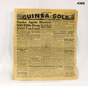 Bendigo Military Museum
Newspaper - NEWSPAPER, 1945, Guinea Gold, 16.6.1945
... Some items include, B 29 raids over Osaka, General Blamey in Bougainville, British concessions to India, post war housing plan, Soviet Govt announces trial of Polish leaders, the races, civilian news....Bendigo Military Museum 37 - 39 Pall Mall Bendigo goldfields Some items include, B 29 raids over Osaka, General Blamey in Bougainville, British concessions to India, post war housing plan, Soviet Govt announces trial of Polish leaders, the races, civilian news. guinea gold newspapers 1945 ON Front, “Vol 3 No 209 - Sat June 16 1945” Newspaper, Guinea Gold, yellowed, 4 pages, all printing in Black, no illustrations or photos. ...Some items include, B 29 raids over Osaka, General Blamey in Bougainville, British concessions to India, post war housing plan, Soviet Govt announces trial of Polish leaders, the races, civilian news.Newspaper, Guinea Gold, yellowed, 4 pages, all printing in Black, no illustrations or photos.ON Front, “Vol 3 No 209 - Sat June 16 1945”guinea gold, newspapers, 1945 -
 City of Moorabbin Historical Society (Operating the Box Cottage Museum)
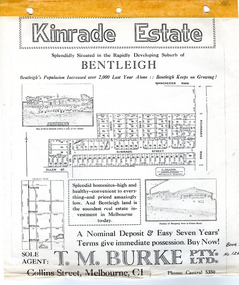
Flyer - Kinrade Estate, Bentleigh East
... This factory was closed in XXXX and a development firm purchased the land and subdivided the land into housing blocks....This factory was closed in XXXX and a development firm purchased the land and subdivided the land into housing blocks. Example of the progress of the Municipality of Moorabbin Leary Avenue Charles Street Peter Leary John Joseph kinrade Tucker Road East Boundary road Clover Estate Kinrade Estate Bentleigh Cyclone Company Ardena Court Bentleigh East Advertising flyer for auction of real estate sales - plan of building blocks for sale Flyer Kinrade Estate, Bentleigh East ...Kinrade Estate was not subdivided as shown in flyer. The land was purchased by Cyclone in 1950. Cyclone built a factory which manufactured wire material. This factory was closed in XXXX and a development firm purchased the land and subdivided the land into housing blocks.Example of the progress of the Municipality of MoorabbinAdvertising flyer for auction of real estate sales - plan of building blocks for saleleary avenue, charles street, peter leary, john joseph kinrade, tucker road, east boundary road, clover estate, kinrade estate, bentleigh, cyclone company, ardena court, bentleigh east -
 Hume City Civic Collection
Photograph, early 1980s
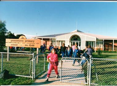
... Goonawarra Primary School was opened in the early 1980s to accommodate children who were living in the Goonawarra Housing Estate. Prior to development this area was known as Goonawarra Farm and John McMahon grazed his dairy cattle on the land....Hume City Civic Collection 44 Macedon Street Sunbury melbourne Goonawarra Primary School was opened in the early 1980s to accommodate children who were living in the Goonawarra Housing Estate. Prior to development this area was known as Goonawarra Farm and John McMahon grazed his dairy cattle on the land. state education schools goonawarra primary school goonawarra housing estate goonawarra farm ministry of education george evans collection A coloured photograph of the Goonawarra Primary School and main gate with school children leaving the grounds. ...Goonawarra Primary School was opened in the early 1980s to accommodate children who were living in the Goonawarra Housing Estate. Prior to development this area was known as Goonawarra Farm and John McMahon grazed his dairy cattle on the land.A coloured photograph of the Goonawarra Primary School and main gate with school children leaving the grounds. A girl dressed in a pink tracksuit is at the gate.state education, schools, goonawarra primary school, goonawarra housing estate, goonawarra farm, ministry of education, george evans collection -
 Hume City Civic Collection
Photograph, early 1980s
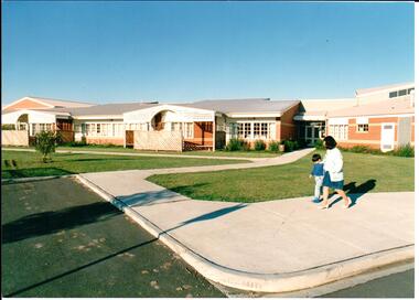
... Goonawarra Primary School was opened in the early 1980s to accommodate children who were living in the Goonawarra Housing Estate. Prior to development this area was known as Goonawarra Farm and John McMahon grazed his dairy cattle on the land....Hume City Civic Collection 44 Macedon Street Sunbury melbourne Goonawarra Primary School was opened in the early 1980s to accommodate children who were living in the Goonawarra Housing Estate. Prior to development this area was known as Goonawarra Farm and John McMahon grazed his dairy cattle on the land. state education schools goonawarra primary school goonawarra housing estate goonawarra farm ministry of education george evans collection A coloured photograph of the recently completed Goonawarra Primary School. ...Goonawarra Primary School was opened in the early 1980s to accommodate children who were living in the Goonawarra Housing Estate. Prior to development this area was known as Goonawarra Farm and John McMahon grazed his dairy cattle on the land.A coloured photograph of the recently completed Goonawarra Primary School. A lady and little boy are walking along the footpath in front of the building. There is an expanse of lawn between the path and the building.state education, schools, goonawarra primary school, goonawarra housing estate, goonawarra farm, ministry of education, george evans collection -
 Lake Bolac & District Historical Society
Colour photograph, Lake Bolac Flax Mill, 1960
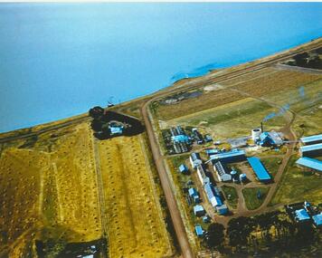
... Aerial view of the Lake Bolac Flax Mill, circa 1960. Note the pump housing in front of Guy Rance's home, the polluted water entering the lake from the pipeline and the stooks of flax to the left of the road opposite the Mill....Lake Bolac & District Historical Society 2110 Glenelg Highway Lake Bolac grampians Aerial view of the Lake Bolac Flax Mill, circa 1960. Note the pump housing in front of Guy Rance's home, the polluted water entering the lake from the pipeline and the stooks of flax to the left of the road opposite the Mill. lake bolac, flax mill, 1960, rance Lake Bolac Flax Mill, 1960. ...Aerial view of the Lake Bolac Flax Mill, circa 1960. Note the pump housing in front of Guy Rance's home, the polluted water entering the lake from the pipeline and the stooks of flax to the left of the road opposite the Mill.lake bolac, flax mill, 1960, rance -
 Whitehorse Historical Society Inc.
Photograph - Black and white photo, Winlaton Youth Training Centre
... When the institution was closed the buildings were demolished and the land subdivided for housing....When the institution was closed the buildings were demolished and the land subdivided for housing. Winlaton Youth Training Centre Nunawading Four girls standing in the grounds of Winlaton outside a building. ...A house on the site was originally owned by successful businessman , Joseph Tweedle before being sold to the government. For many years it was the Winlaton Training Centre for girls. When the institution was closed the buildings were demolished and the land subdivided for housing.Four girls standing in the grounds of Winlaton outside a building.winlaton youth training centre, nunawading -
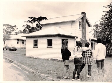
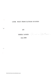 Eltham District Historical Society Inc
Document - Folder, Look West from Eltham Station by Derek Sawer, June 2000
... ...housing...Preface written by Diana Bassett-Smith harry gilham collection reminiscences derek sawer peter sawer diana bassett-smith john harcourt housing 5 pages Look West from Eltham Station by Derek Sawer Document Folder ...Folder no 65 of the Harry Gilham collection. Reminscences writiten by Peter Sawer, also known as Peter Sawer about living in Eltham after the war from 1945 in the development west of the railway station known as Highbrow Hill. Preface written by Diana Bassett-Smith5 pagesharry gilham collection, reminiscences, derek sawer, peter sawer, diana bassett-smith, john harcourt, housing -
 City of Ballarat Libraries
Photograph, Elizabeth Street, Allendale circa 1890
... ...housing...Shown in the photo is Annie Buik, Esther & George Wells. creswick elizabeth road allendale road buik wells house housing Elizabeth Street, Allendale circa 1890. ...This house in Elizabeth Street, Allendale was a weatherboard with a shingle roof and veranda. Shown in the photo is Annie Buik, Esther & George Wells.creswick, elizabeth road, allendale road, buik, wells, house, housing -
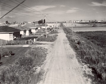 City of Kingston
Photograph - Black and white, c. 1960
... ...Housing...Bentleigh East Bentleigh Market Garden Housing Suburbs Infrastructure Moorabbin Handwritten in blue ink: 60 - 373 D Handwritten in red ink: 80% Handwritten in black ink: Ch. 6 Black and white photograph of unsealed road in new development in the area of Moorabbin, new houses appear on the lefthand side with paddocks on right side of image with installation of electric poles. ...This image depicts a scene of East Bentleigh in 1960, viewed along Thomasina Street as it crosses Gladwyn Street towards East Boundary Road in the distance. The gardens and new homes are well-tended, but the street surfacing is unsealed.Developing urban area now located within the City of Glen Eira, formally City of Moorabbin. This image illustrates the mid century urban sprawl of new suburbs and the subdivision of market gardens within the municipality and the changing demographic of the district as new houses are constructed and infrastructure established. Black and white photograph of unsealed road in new development in the area of Moorabbin, new houses appear on the lefthand side with paddocks on right side of image with installation of electric poles. Sealed road in the distance. Thomasina Street, as it crosses Gladwyn Street, East Bentleigh towards East Boundary Road. Handwritten in blue ink: 60 - 373 D Handwritten in red ink: 80% Handwritten in black ink: Ch. 6bentleigh, east bentleigh, market garden, housing, suburbs, infrastructure, moorabbin -
 City of Melbourne Libraries
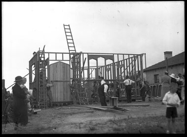
House construction at Yarraville for Imperial Chemicals
... housing...housing yarraville 1930-1939 industry construction timber houses industrial activities House construction at Yarraville for Imperial Chemicals ...housing, yarraville, 1930-1939, industry, construction, timber houses, industrial activitieshousing, yarraville, 1930-1939, industry, construction, timber houses, industrial activities -
 Bendigo Military Museum
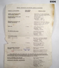
Document - GENERAL INFORMATION FOR NATIONAL SERVICE DISCHARGE
... Form shows contact points for various categories of service, i.e. Legal Aid, Housing Loans, Pensions etc, that the National Service may have a right to, also shows time limits that may apply....Form shows contact points for various categories of service, i.e. Legal Aid, Housing Loans, Pensions etc, that the National Service may have a right to, also shows time limits that may apply. ...Ref Cat No.754. Form shows contact points for various categories of service, i.e. Legal Aid, Housing Loans, Pensions etc, that the National Service may have a right to, also shows time limits that may apply.Single sheet white paper A.4 size with tattered bottom edge with general information that may be required on discharge. Writing only on one side.Against line "Advise and Counselling" written in blue pen "Brian Dorizzi C627117".national service, discharge information. -
 Hume City Civic Collection
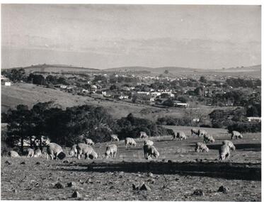
Photograph, Early 1970s
... The photograph was taken when Sunbury township did not extend far beyond Anderson Road to the west and Powlett Street to the east. The Paynes housing development can be seen scattered across the hillside between Gap Road and Mitchells Lane....Hume City Civic Collection 44 Macedon Street Sunbury melbourne The photograph was taken when Sunbury township did not extend far beyond Anderson Road to the west and Powlett Street to the east. The Paynes housing development can be seen scattered across the hillside between Gap Road and Mitchells Lane. sunbury township goonawarra winery george evans collection A black and white photograph of a panoramic view of Sunbury township looking west and taken from above the Goonawarra Winery. ...The photograph was taken when Sunbury township did not extend far beyond Anderson Road to the west and Powlett Street to the east. The Paynes housing development can be seen scattered across the hillside between Gap Road and Mitchells Lane.A black and white photograph of a panoramic view of Sunbury township looking west and taken from above the Goonawarra Winery. Sheep are grazing on the hilside in the foreground.sunbury township, goonawarra winery, george evans collection -
 Kiewa Valley Historical Society
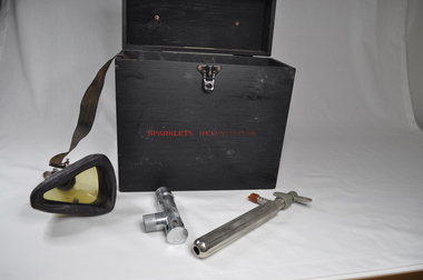
Portable Resuscitator Electric Therapy Unit
... A wooden lockable case, housing electrical equipment suitable for issuing high voltage shocks....A wooden lockable case, housing electrical equipment suitable for issuing high voltage shocks. ...A shock of different voltages was delivered to a person using the two metal handles or two heavy soft wire combs (missing but known of) were moved across the skin. Perhaps this was an early TENS Unit. The unit came to the donor's grandfather (Roy F. Leibig - Chief Electrical Inspector of the Brunswick (Melbourne) Electric Supply) for repair and returned to his keeping once it had become obsolete (upgraded by newer machine). Donor often helped his Pa repair electrical equipment.Historical: The Resuscitator or Electric Therapy Unit was used in hospitals, possibly Mental hospitals. Provenance: The donor worked at Mt Beauty in the Kiewa Hydro Electric Scheme with the State Electric Commission of Victoria as an electrician. Black wooden smooth box with clip fastener which is screwed on - 3 screws for the base and 2 for the lid. On top of the box is a leather strap for the handle fastened by steel screwed into the box. Inside: A mask with attached strap. Tap fitting loosely into steel box. Metal cylinders and a Cardboard box. A wooden lockable case, housing electrical equipment suitable for issuing high voltage shocks.In red, middle of the side with fastener - "SPARKLETS RESUSCITATOR" Scruff marks inside the lid. A cream plastic tag is screwed on and inscribed"Manufacturers:- / SPARKLETS LIMITED / EDMONTON, LONDON, N.18 / Made in ENGLANDmedical, hospital equipment, resuscitator, tawonga district hospital, doctor -
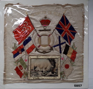 Bendigo Military Museum
Souvenir - BANNER, SILK WW1, c.WW1
... At the bottom of the banner is a gold coloured rectangular frame housing a coloured print of a naval battle. ...At the bottom of the banner is a gold coloured rectangular frame housing a coloured print of a naval battle. ...Banner was souvenired by Trooper Frank J. Fry, 3rd ALH Regiment No 2315. Trooper Fry also served in the Imperial Camel Corps in Palestine from 1916 to mid 1918 when he rejoined the 3rd ALH Regiment White silk banner featuring the flags of eight WW1 allied nations (Great Britian, France, Belgium, Japan, Serbia, Italy, Russia, Egypt.) The flags surround a raised life buoy over an embroidered anchor. Inside the life buoy is space for a photograph. At the bottom of the banner is a gold coloured rectangular frame housing a coloured print of a naval battle. The banner is topped with "Victory for the Allies."Over an embroidered King's Crown Banner is mounted on cardboard and covered with a clear cellophane Embroidered on top of banner. "Victory to the Allies."souvenier, ww1, flags, trooper frank j. fry. -
 Kiewa Valley Historical Society
Ash Tray Pocket, Circa mid to late 1900s
... The opening lid is spring loaded, hinged top, circular and fixed by a clasp, pop- riveted (4) onto the main housing. Opposite the hinge the lid is held closed by a small metal ball fitting tightly to the top wall of the container. ...The opening lid is spring loaded, hinged top, circular and fixed by a clasp, pop- riveted (4) onto the main housing. Opposite the hinge the lid is held closed by a small metal ball fitting tightly to the top wall of the container. ...This flip top pocket steel ash tray was at the beginning of the social "cleaning up" of cigarette ash and related products. This cigarette waste container was for those occasions when it was polite not to throw the cigarette ash and used up cigarettes "buts" on the ground, or if working in any rural area during a dry fire prone season, when discarding burning cigarette waste could set up a severe "bush" fire. It was also at the beginning of an intensive look at the affects of smoking upon the health of users. Later in the 1900s was a time when medical evidence supported a ground swell of the anti smoking movement which resulted in further restrictions of the use cigarette smoking in public places. Before the anti cigarette smoking revolution, it was both fashionable and manly to either roll your own cigarette or open up a packet of "tailor made's". In the rural and man's man environment the roll your own provided a visual acknowledgement that the user was "true blue" Aussie male and not a city boy. The cycle of use of cigarettes has drastically changed from when this item was first used. Today's society (post 2000) has produced a ground swell of government and non government organisations whose aim is provide a cigarette "ash" free environment and society. This is highlighted in the beginning of the 2000 millennium by a cigarette "Free" Australia campaign, and the pocket flip top personal ash tray as a practical solution for butt litter disposal.This pocket ash tray not only was used when social graces required it to, but also provided a container for any unfinished cigarettes or stogies (cheap half used cigars). In rural areas (open fresh air countryside), where time was always made available for the "smoko" (Australian rest period), at any time, especially after some hard physical work, the ability to have a self contained ashing apparatus, not to offend the gentler folk, was a pre-requisite . The rural environment, in the days of these cigarette ash containers,was one which could range from harsh and unforgiving to mild and relaxing. Smoking could be enjoyed anywhere and at any time without too much "fussing" around. This ash tray was mobile, convenient, unobtrusive and regarded by the user as being considerate to those around. It also eliminated the tell tale evidence that the "no smoking" signs had been ignored. The Kiewa Valley was like many rural ares that found it hard for smokers to come to grips with a governmental "non smoking policy" to indoor recreational and other "confined space" environments. Tin plated mild steel round container with a lid. The opening lid is spring loaded, hinged top, circular and fixed by a clasp, pop- riveted (4) onto the main housing. Opposite the hinge the lid is held closed by a small metal ball fitting tightly to the top wall of the container. The lid is opened by the use of a fingernail positioned at junction of lid to body. This edge is bevelled to allow access. personal effects, tobacco waste products, smoking accessories -
 St James Old Cathedral
Cathedral Building, St James Old Cathedral, 09/11/1839
... Octagonal upper one storey bell tower housing eight bells supported by two storey square towers. ...Octagonal upper one storey bell tower housing eight bells supported by two storey square towers. ...St James Church, "Church of the Pioneers", was the first Church, first Anglican Church, and is the oldest building in Melbourne. The foundation stone was laid in 1839 by the Superintendent of the District of Bourke, Charles La Trobe, later Governor of the Colony of Victoria. The Church was opened in 1842 and the first Bishop Charles Perry was installed in the Cathedral in 1848 when its status changed to that of Cathedral. Its status changed back to that of a Parish church after 1891 when St Paul's Cathedral in Swanston Street was opened. St James is known as the "Church of the Pioneers" as it served as the place of worship, marriage, baptism and burial of many of the first families in the District of Bourke and the Colony of Victoria. St James Old Cathedral is of the most important historic value to the community of Victoria and to the Australian nation as the first Anglican Church founded within 4 years of the settlement of Melbourne. It represents and conserves the very earliest history of white settlement in Victoria and preserves the church associated history of the Pioneer families of Victoria in its collection of original records and artefacts. Late Neo-Georgian style stone church building with bluestone footings. Octagonal upper one storey bell tower housing eight bells supported by two storey square towers. Body of church has sloping roof and 4 stained glass ornamental windows on each of west and east sides with decorative sanctuary window to the north. Decorative Portico with columns on the north outside elevation. National Trust Commemorative plate on outside wall to right of east entry door.