Showing 4055 items matching "landscape"
-
 Charlton Golden Grains Museum Inc
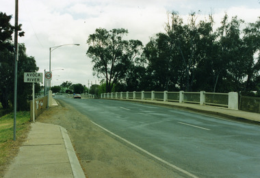
Photograph, James Patterson Bridge
... Landscape Coloured Photograph...James Patterson Bridge Avoca River Calder Highway Bridge accross Avoca River Charlton Vic. 3525 Landscape Coloured Photograph James Patterson Bridge Photograph ...Landscape Coloured Photographjames patterson bridge, avoca river, calder highway bridge accross avoca river charlton vic. 3525 -
 Charlton Golden Grains Museum Inc
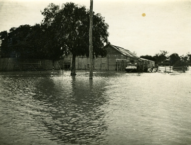
Photograph, 1909-1911 Charlton Flood
... Landscape Sepia Photograph...1909 Floods Landscape Sepia Photograph 1909-1911 Charlton Flood Photograph ...Landscape Sepia Photograph1909 floods -
 Charlton Golden Grains Museum Inc
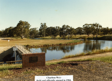
Photograph, New Charlton Weir C.1987
... Landscape Coloured Photograph...Avoca River New Charlton Weir Barry Steggall MLA November 1984 Landscape Coloured Photograph New Charlton Weir C.1987 Photograph ...Landscape Coloured Photographavoca river, new charlton weir, barry steggall mla, november 1984 -
 Charlton Golden Grains Museum Inc
Photograph, Bridge over Avoca River built in 1925
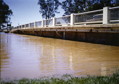
... Landscape Coloured Photograph...Officially named James Patterson Bridge in 1995 in honour of the builder of the first bridge in 1867 Landscape Coloured Photograph Bridge over Avoca River built in 1925 Photograph ...Landscape Coloured PhotographBridge built over the Avoca River in 1925 by H>B> Irwin. Lengthened in 1940, widened in 1964 and strengthened in 1992. Officially named James Patterson Bridge in 1995 in honour of the builder of the first bridge in 1867charlton flood 1995, james patterson, james patterson bridge, h.b. irwin, avoca river -
 City of Stonnington
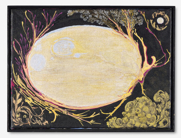
Alex Pittendrigh, Phenomenon, 2008
... ...Landscape...In this dark landscape-like image, viewed from above, is a central pale yellow shape, bordered irregularly by twig-like forms, which is perhaps the earth, shone on by a moon in the top right. ...Stonnington contemporary art collection Painting Alex Pittendrigh Landscape Memory In this dark landscape-like image, viewed from above, is a central pale yellow shape, bordered irregularly by twig-like forms, which is perhaps the earth, shone on by a moon in the top right. ...Alex Pittendrigh completed a degree in painting at the Victorian College of the Arts in 1994, was awarded an Australia Council residency at The British School in Rome and was a resident artist at Gertrude Contemporary Art Spaces. In his series of three artworks, 'Worlds through worlds III', 'Worlds through worlds IV' and 'Phenomenon', the scenes appear as if extricated through a kind of portal or void. They are landscapes as imagined or perhaps remembered, ‘pictured’ in the mind’s eye. Seen as an exercise in rococo excess and ornamentation, these artworks suggest a tension between the ornamental and pictorial. The decorative filigree within the painted surface set these scenes further away from the real world. They are ideal, and idealised, places that remain at a distance.In this dark landscape-like image, viewed from above, is a central pale yellow shape, bordered irregularly by twig-like forms, which is perhaps the earth, shone on by a moon in the top right. Ornamental vegetation - leaves, grapes - appear to be spinning off the earth into corners or out of the frame. Acrylic and ink on linen.stonnington contemporary art collection, painting, alex pittendrigh, landscape, memory -
 Whitehorse Historical Society Inc.
Document, East Burwood Reserve, 1/08/1992
... Landscape guide lines, Prepared by Andrew Paxton Landscapes in conjunction with City of Nunawading Parks & Recreation Services...Whitehorse Historical Society Inc. 2-10 Deep Creek Road Mitcham melbourne Parks & Reserves Andrew Paxton Landscapes East Burwood Reserve City of Nunawading Parks and Recreation Services Landscape guide lines, Prepared by Andrew Paxton Landscapes in conjunction with City of Nunawading Parks & Recreation Services East Burwood Reserve Document Document ...Landscape guide lines, Prepared by Andrew Paxton Landscapes in conjunction with City of Nunawading Parks & Recreation Servicesparks & reserves, andrew paxton landscapes, east burwood reserve, city of nunawading parks and recreation services -
 Glen Eira Historical Society
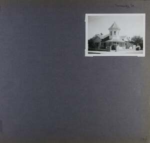
Album - Album page, Normanby Road, Circa 1972
... Normanby Road retains its comparatively opulent Edwardian character in a mature landscaped setting with spacious gardens and mature planes parallel with the railway reserve which, on account of the low lying ground in its vicinity has a high embankment commencing on the alignment of Malvern Grove and continuing to Caulfield Station. ...Page 148 of Photograph Album with one landscape photograph of a house on Normanby Road (not Street)....Normanby Road retains its comparatively opulent Edwardian character in a mature landscaped setting with spacious gardens and mature planes parallel with the railway reserve which, on account of the low lying ground in its vicinity has a high embankment commencing on the alignment of Malvern Grove and continuing to Caulfield Station. ...This photograph is part of the Caulfield Historical Album 1972. This album was created in approximately 1972 as part of a project by the Caulfield Historical Society to assist in identifying buildings worthy of preservation. The album is related to a Survey the Caulfield Historical Society developed in collaboration with the National Trust of Australia (Victoria) and Caulfield City Council to identify historic buildings within the City of Caulfield that warranted the protection of a National Trust Classification. Principal photographer thought to be Trevor Hart, member of Caulfield Historical Society. Most photographs were taken between 1966-1972 with a small number of photographs being older and from unknown sources. All photographs are black and white except where stated, with 386 photographs over 198 pages. From: Glen Eira Heritage Management Plan (1996) - Vol 2 by Andrew Ward and Associates The widening of Dandenong Road during the late 1980's has resulted in the destruction of the houses in the path of the roadworks and the construction of a high fence serving as a visual barrier between that thoroughfare and the remaining houses. Where comparatively large villas once stood on spacious allotments, only "Wisteria" survives at No. 135 Normanby Road. Adopting forms and timber enrichment characteristic of the American Queen Anne style, it has this in common with the largely reconstructed timber villa at no. 11 Normanby Avenue and to a lesser extent, 746 Inkerman Road. Normanby Road retains its comparatively opulent Edwardian character in a mature landscaped setting with spacious gardens and mature planes parallel with the railway reserve which, on account of the low lying ground in its vicinity has a high embankment commencing on the alignment of Malvern Grove and continuing to Caulfield Station. The earliest villas are Edwardian. Page 148 of Photograph Album with one landscape photograph of a house on Normanby Road (not Street).Handwritten: Normanby St [top right] / 148 [bottom right]trevor hart, verandah, porch, bull nosed verandah, tower house, tower, stone fence, normanby road, wisteria, american queen anne style, queen anne style, 1890's, mayfield grove, normanby street, timber houses, caulfield north, house names, edwardian, edwardian style, gardens -
 Wyndham Art Gallery (Wyndham City Council)
Photograph, Anne Scott Wilson, Fly Rhythm Dandenong series #1, 2013
... ...Landscape...The images in Fly Rhythm series record landscapes from the Dandenong Ranges to Altona and were produced for an exhibition at the Wyndham Art Gallery called EXPERIMENT in 2012....Australian Art Australian Photography Photography Female artist Landscape Fly Rhythm Dandenong series #1 Photograph Anne Scott Wilson ...Anne Scott Wilson is a video and photography artist interested in memory, motion and the body. Her work often experiments with movement and light exposure over time. The images in Fly Rhythm series record landscapes from the Dandenong Ranges to Altona and were produced for an exhibition at the Wyndham Art Gallery called EXPERIMENT in 2012.australian art, australian photography, photography, female artist, landscape -
Port Melbourne Historical & Preservation Society
Audio - Landscape of settlement, Jenny Lee, 24 Aug 2009
... Jenny Lee - Landscape of the settlement...Port Melbourne Historical & Preservation Society Port Melbourne Town Hall 333 Bay Street Port Melbourne melbourne Natural Environment Built Environment Duration 01:06:15 Jenny Lee - Landscape of the settlement Audio Landscape of settlement, Jenny Lee ...Jenny Lee - Landscape of the settlementDuration 01:06:15natural environment, built environment -
 Bendigo Historical Society Inc.
Photograph - COLOUR PHOTOGRAPH OF BUILDING
... COLOUR PHOTOGRAPH OF building / landscape....History House 11 Mackenzie Street Bendigo goldfields PHOTOGRAPH Building COLOUR PHOTOGRAPH OF building / landscape. Photograph COLOUR PHOTOGRAPH OF BUILDING ...COLOUR PHOTOGRAPH OF building / landscape.photograph, building -
Glenelg Shire Council Cultural Collection
Slide - Slide - Construction Portland/Cashmore airport, c. 1980
... Coloured slide. Featureless landscape....Glenelg Shire Council Cultural Collection History House Cliff Street Portland great-ocean-road Coloured slide. Featureless landscape. Slide Slide - Construction Portland/Cashmore airport ...Coloured slide. Featureless landscape. -
 Melbourne Royal
Photograph, 1976
... Black and white photograph, landscape....Tim Morgan 23/4/2013 Black and white photograph, landscape. Photograph RASV Photograph ...The Sun Country Show Girl Quest, 1976. This presentation is on the stage of Wool Court on the Showgrounds. The compere in the suit is Brian Naylor. Naylor was an RASV Councillor from 1977-83 and a well-known news presenter, particularly for Channel 9. He often provided commentary and was a compere for several Show events, including the Miss Show Girl competition, Arts and Crafts, and the Australian Wool Corporation's Wool Fashion Parades, both before and during his time on Council.Black and white photograph, landscape.[Inscription on A4 History/Identification Project placed with photo] Approx date: 1976. The late Brian Naylor, Channel 7/9 news reader, RASV councillor. Presentation of Showgirl finalists on stage at Wool Court. Tim Morgan 23/4/2013royal melbourne show, naylor, brian naylor, miss show girl, sun miss show girl, 1976 royal melbourne show -
 Royal Australasian College of Surgeons Museum and Archives
Painting - Untitled landscape by Ray Crooke, Ray Crooke
... Untitled landscape by Ray Crooke...Royal Australasian College of Surgeons Museum and Archives 250-290 Spring Street East Melbourne melbourne Ray Crooke Untitled landscape by Ray Crooke Painting Untitled landscape by Ray Crooke Ray Crooke ...Untitled landscape by Ray Crookeray crooke -
 Royal Australasian College of Surgeons Museum and Archives
Painting - Painting, Mount Conway, Central Australia by L. Graham, Graham, Les, 1975
... Landscape with kangaroos and mountains in background...TYPED INFORMATION SHEET ATTACHED VERSO. Landscape with kangaroos and mountains in background Painting, Mount Conway, Central Australia by L. ...Landscape with kangaroos and mountains in backgroundARTISTS SIGNATURE LOWER LEFT "LES GRAHAM". TYPED INFORMATION SHEET ATTACHED VERSO. -
Clunes Museum
Negative - NEGATIVES
... 2 NEGATIVES OF VARIOUS LANDSCAPES....LOCAL HISTORY PHOTOGRAPHY PHOTOGRAPHS NEGATIVES 2 NEGATIVES OF VARIOUS LANDSCAPES. Negative NEGATIVES ...LEONARD CARTER WAS A PHOTOGRAPHER. HE ORIGINALLY LIVED IN CLUNES AND LATER IN APOLLO BAY. FAMILY HOME WHERE ROBERT CAMPBELL NOW LIVES.2 NEGATIVES OF VARIOUS LANDSCAPES.local history, photography, photographs, negatives, -
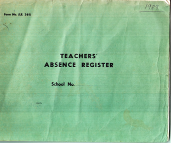 Grey Street Primary School, Traralgon
Book, Teachers' Absence Register 1989
... Green covered paperback, landscape....Primary School, Traralgon in 1989 and any replacement teachers employed. traralgon teacher register primary school grey street. state school Form No LE 361 (Education Dept of Victoria) Green covered paperback, landscape. Teachers' Absence Register 1989 Book ...In 1989 the Principal was required to record the absence of each Teacher, their Educ. Dept. registration number, the date and reason for the absence ( and in this instance the name of the replacement teacher employed.) A list of replacement teachers is included inside the front cover.List of staff teaching at Grey St. Primary School, Traralgon in 1989 and any replacement teachers employed. Green covered paperback, landscape.Form No LE 361 (Education Dept of Victoria)traralgon, teacher register, primary school, grey street., state school -
Lakes Entrance Historical Society
Booklet, Gippsland Lakes Complete Health, 50th Annual Report Lakes Entrance Community Health Centre, 2025
... Landscape with brown cover with on frontphotographs ...Commenced activities, 27th October, 1975 Landscape with brown cover with on frontphotographs 50th Annual Report Lakes Entrance Community Health Centre Booklet Gippsland Lakes Complete Health ...Message from CEO and Chair, Year review, Board members past and present, Review of 50 years, Bairnsdale story, Bruthen and Metung healthcare, Drought, fire, global pandemic.Landscape with brown cover with on frontphotographs Message from CEO and Chair, Year review, Board members past and present, Review of 50 years, Bairnsdale story, Bruthen and Metung healthcare, Drought, fire, global pandemic.healthcare, celebration, community services -
 Robin Boyd Foundation
Painting, Arthur Boyd, Wheat Fields Behind Rosebud, 1938
... Landscape in gold wooden frame...This means that Arthur Boyd was a first cousin to both Robin Boyd and Patricia Madder. arthur boyd arthur merric boyd robin boyd walsh st artwork OHM2022 OHM2022_1 A.M.B Boyd 1938 on lower right hand side Landscape in gold wooden frame Wheat Fields Behind Rosebud Painting Arthur Boyd ...In 1938, Robin Boyd's grandfather Arthur Merric Boyd offered Robin his first commission, a studio for Robin's first cousin Arthur Boyd on the family property at Murrumbeena. This painting by Arthur Boyd was part of Ralph Madder’s estate and inherited by his daughter, Patricia, Robin Boyd's wife. Ralph Madder (1892 - 1986) was Arthur Boyd’s uncle and employed the young Arthur in his calcimine paint factory and bought the occasional painting to help the young artist. This painting dates from a later time when Arthur was living with, and looking after, his aged grandfather Arthur Merric at Rosebud (see the book “The Boyds” by Brenda Niall pages 188-9). “Wheat fields behind Rosebud” did not come to 290 Walsh Street until after Ralph Madder’s death in 1986. Note: Robin Boyd's uncle Merric Boyd (1888-1959) married Patricia’s aunt Doris Gough. This means that Arthur Boyd was a first cousin to both Robin Boyd and Patricia Madder. Landscape in gold wooden frameA.M.B Boyd 1938 on lower right hand sidearthur boyd, arthur merric boyd, robin boyd, walsh st artwork, ohm2022, ohm2022_1 -
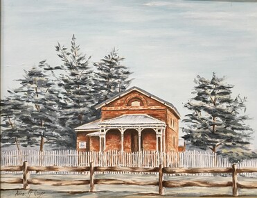
 Stawell Historical Society Inc
Photograph, Armstrong Railway Station, 07.11.2021
... Colour Photograph Landscape: of Building...Colour Photograph Landscape: of Building Armstrong Railway Station Photograph ...Armstong Railway Station now at Deep Lead Private Property has been there since Purchased in 1993. Converted to family accommodation when they visit owner gave permission for photograph to come to Stawell Historical Society.Colour Photograph Landscape: of Building -
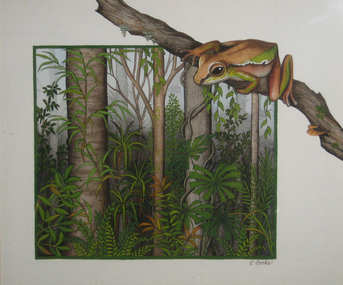 Federation University Art Collection
Painting, Lyn Cooke, 'Rainforest Home' by Lynne Cooke
... Framed painting of a frog in landscape....Cooke' Framed painting of a frog in landscape. 'Rainforest Home' by Lynne Cooke Painting Lyn Cooke ...Lyn COOKE An artist specialising in wildlife, Lyn Cooke draws from the rich heritage of wildlife art in Australia beginning with the natural history illustrations of John William Lewin and John and Elizabeth Gould. Her aim is to accurately depict the natural environment and this is reflected in her highly detailed paintings. This item is part of the Federation University Art Collection. The Art Collection features over 2000 works and was listed as a 'Ballarat Treasure' in 2007.Framed painting of a frog in landscape.Signed lrs 'L. Cooke'art, artwork, lyn cooke, frog, available, rainforest -
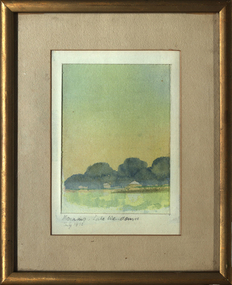 Federation University Art Collection
Painting - Watercolour, David Alexander, 'Morning: Lake Wendouree' 1973, by David Alexander, 07/1973
... Small framed landscape, 1973...The Art Collection features over 1000 works and was listed as a 'Ballarat Treasure' in 2007. art artwork david alexander lake wendouree available Lower left "Morning, Lake Wendouree July 1973 Small framed landscape, 1973 'Morning: Lake Wendouree' 1973, by David Alexander Painting Watercolour David Alexander ...This item is part of the Federation University Art Collection. The Art Collection features over 1000 works and was listed as a 'Ballarat Treasure' in 2007.Small framed landscape, 1973Lower left "Morning, Lake Wendouree July 1973art, artwork, david alexander, lake wendouree, available -
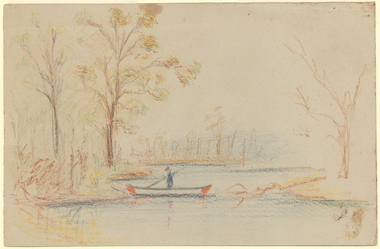 Latrobe Regional Gallery
Drawing, Unknown, Untitled
... Drawing of a figure in a boat in a landscape....Latrobe Regional Gallery 138 Commercial Road Morwell gippsland Drawing of a figure in a boat in a landscape. Untitled Drawing Unknown ...Drawing of a figure in a boat in a landscape. -
Tarnagulla History Archive
Copy photos: Murray Comrie Glass Plate Images
... A3 Landscape Display book. ...Compiled by David Gordon A3 Landscape Display book. Copy photos: Murray Comrie Glass Plate Images Stokes & Son ...David Gordon Collection. Compiled by David Gordon A3 Landscape Display book. -
 Pyrenees Shire Council
painting, Dawn Lim, Barkley and Beyond by Dawn Lim, c2106
... painting of landscape with mountain range...Pyrenees Shire Council 5 Lawrence Street Beaufort grampians significant as a work of art by local Pyrenees artist, locally significant to the Central Highlands Region of Victoria as a representation of local landscape and/or culture "Signed: D LIM (lower right) Verso (affixed): DAWN LIM BARKLEY & BEYOND $250 Acylic " painting of landscape with mountain range Barkley and Beyond by Dawn Lim painting Dawn Lim ...significant as a work of art by local Pyrenees artist, locally significant to the Central Highlands Region of Victoria as a representation of local landscape and/or culture painting of landscape with mountain range"Signed: D LIM (lower right) Verso (affixed): DAWN LIM BARKLEY & BEYOND $250 Acylic " -
 Pyrenees Shire Council
painting, Heather Featherson, Beaufort from Camp Hill by Heather Featherson, 2007
... Landscape painting of Beaufort Township...Pyrenees Shire Council 5 Lawrence Street Beaufort grampians significant as a work of art by local Pyrenees artist, locally significant to the Central Highlands Region of Victoria as a representation of local landscape and/or culture signed: H FEATHERSTON (lower right) Landscape painting of Beaufort Township Beaufort from Camp Hill by Heather Featherson painting Heather Featherson ...significant as a work of art by local Pyrenees artist, locally significant to the Central Highlands Region of Victoria as a representation of local landscape and/or culture Landscape painting of Beaufort Townshipsigned: H FEATHERSTON (lower right) -
 Pyrenees Shire Council
painting, Anne McGregor, Untitled (Lexton Shire), c1985
... landscape with Lexton Shire Offices...Pyrenees Shire Council 5 Lawrence Street Beaufort grampians significant as a work of art by local Pyrenees artist, locally significant to the Central Highlands Region of Victoria as a representation of local landscape and/or culture Affixed front: Presented by Lexton's Anniversary Committee to the Lexton Shire Council IN RECOOGNITION OF IT'S VALUABLE SUPPORT & ASSISTANCE IN THIS, VICTORIA'S 150TH ANNIVERSARY YEAR 14-4-85 landscape with Lexton Shire Offices Untitled (Lexton Shire) painting Anne McGregor ...significant as a work of art by local Pyrenees artist, locally significant to the Central Highlands Region of Victoria as a representation of local landscape and/or culturelandscape with Lexton Shire OfficesAffixed front: Presented by Lexton's Anniversary Committee to the Lexton Shire Council IN RECOOGNITION OF IT'S VALUABLE SUPPORT & ASSISTANCE IN THIS, VICTORIA'S 150TH ANNIVERSARY YEAR 14-4-85 -
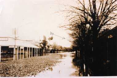 Charlton Golden Grains Museum Inc
Photograph, 1923 Flood High Street Charlton (shows Tinsmith shop of William McConnell - arrowed)
... Landscape unframed sepia photo...The water rose to 6 inches over the floor and boats were able to travel this street. Landscape unframed sepia photo 1923 Flood High Street Charlton (shows Tinsmith shop of William McConnell - arrowed) Photograph ...Landscape unframed sepia photo1st August 1923. Floods Charlton - shows Tinsmith shop William McConnell, The flood water had started to fall when photo taken in the Mainstreet. The water rose to 6 inches over the floor and boats were able to travel this street.floods 1923, high st charlton, tinsmith shop, william mcconnell -
 Charlton Golden Grains Museum Inc
Photograph, Avoca River
... Landscape Sepia Photograph Unfamed...Grace Cadgow James Patterson Avoca River James Patterson Bridge Photo handed through the family of James Patterson (builder) of the first bridge accross the Avoca River at Charlton. Landscape Sepia Photograph Unfamed Avoca River Photograph ...Landscape Sepia Photograph UnfamedPhoto handed through the family of James Patterson (builder) of the first bridge accross the Avoca River at Charlton.grace cadgow james patterson, avoca river, james patterson bridge -
 University of Melbourne, Burnley Campus Archives
Photograph - Colour print, Burnley Campus Archives, The Dairy Shed in 1990, 1990
... In the 1980's it was used for storage of landscape and arboriculture equipment."...In the 1980's it was used for storage of landscape and arboriculture equipment." Colour photograph pasted on polystyrene board. ...Appears to have been used in an exhibitionColour photograph pasted on polystyrene board. Renovated and repurposed DairyCaption, "The dairy shed in 1990, by now reclad. In the 1980's it was used for storage of landscape and arboriculture equipment."dairy shed, storage, equipment, dairy, renovated -
 Glenelg Shire Council Cultural Collection
Work on paper - Watercolour, Florence Tatham Mellblom, Portland Shire Hall, n.d
... ...Landscape...A bluestone building on an arid landscape. Yellow grass in the foreground with one tree standing at the front. ...Female Artist Women Female Landscape Portland Landscape Portland Shire Bottom Right - F. ...From Antiques Reporter: Florence Tatham Mellblom, (Australian, 1900 - 1983), Visit Portland The First Victorian Settlement, during the Centenary Celebrations from 15th to 23rd November 1934', 1934 colour lithograph, signed 'F. Mellblom' in image lower left, 63.5 x 101.5 cm. Linen-backed. Text continues in lower margin: 'Arbuckle, Waddell Pty Ltd Print, Melb.', Mellblom (nee Henry) was a painter, naturalist and photographer. She was born at Portland, Victoria, and studied art in Ballarat. She was a talented etcher from childhood, and joined the Portland Camera club. She also produced many watercolour paintings of the historic places of Portland. She was married (1932) to Karl Enoch Mellblom.A bluestone building on an arid landscape. Yellow grass in the foreground with one tree standing at the front. There is a blue sky behind. The left hand wing has a door which is slightly open. Above each wing is an engraved piece of stone. Left - Portland, right - Shire. An old rickety fence to the left of the building.Bottom Right - F. Mellblomfemale artist, women, female, landscape, portland landscape, portland shire