Showing 13505 items matching "on-off"
-
 Ringwood and District Historical Society
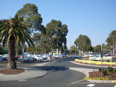
Photograph, Looking along former Adelaide Street, from the access road roundabout, towards the south-east, on 21 April 2009. Showing bus terminus on the other side of the highway, at the station, and former Harris Scarfe store
... roundabout, towards the south-east, on 21 April 2009. Showing bus ...Ron Brons photographic study of Ringwood. -
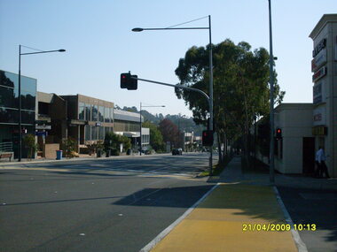
 Ringwood and District Historical Society
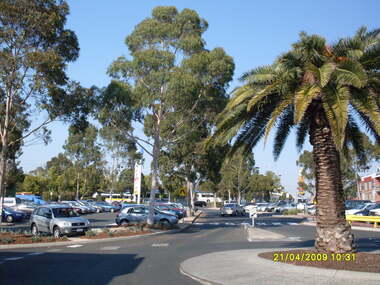
Photograph, Looking along former Adelaide Street, from the access road roundabout, towards the south-east, on 21 April 2009. Showing bus terminus on the other side of the highway, at the station
... roundabout, towards the south-east, on 21 April 2009. Showing bus ...Ron Brons photographic study of Ringwood. -
 Ringwood and District Historical Society
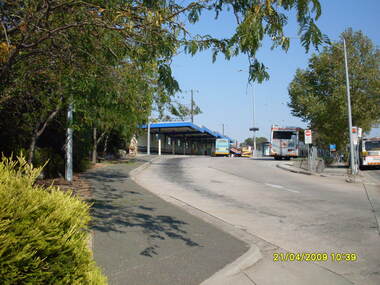
Photograph, Looking along former Adelaide Street, from the access road roundabout, towards the south, on 21 April 2009. Showing bus terminus on the other side of the highway, at the station
... roundabout, towards the south, on 21 April 2009. Showing bus terminus ...Ron Brons photographic study of Ringwood. -
 Ringwood and District Historical Society
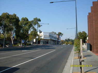
Photograph, Ringwood Street looking south, Ringwood on 21 April 2009. Civic Place on left, with Paul Vale (criminal lawyer)
... Ringwood Street looking south, Ringwood on 21 April 2009 ...Ron Brons photographic study of Ringwood -
 Ringwood and District Historical Society
Photograph, Ringwood Street looking north-west, Ringwood on 21 April 2009. Police Station on left
... Ringwood Street looking north-west, Ringwood on 21 April ...Ron Brons photographic study of Ringwood -
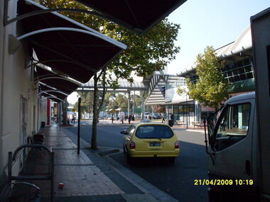 Ringwood and District Historical Society
Photograph, Eastland access road looking east, on 21 April 2009. Showing cab and shops on south side of Eastland
... Eastland access road looking east, on 21 April 2009 ...Ron Brons photographic study of Ringwood. -
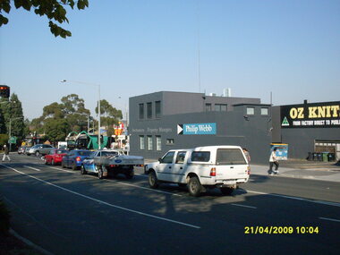 Ringwood and District Historical Society
Photograph, Corner of Maroondah Highway and Ringwood Street looking south, Ringwood on 21 April 2009. Ozknit and Phillip Webb Real Estate on west side of road
... south, Ringwood on 21 April 2009. Ozknit and Phillip Webb Real ...Ron Brons photographic study of Ringwood -
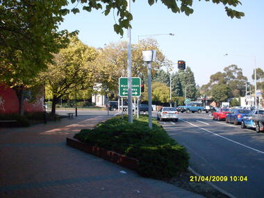 Ringwood and District Historical Society
Photograph, Corner of Maroondah Highway and Wantirna Road looking south taken from Ringwood Street, Ringwood on 21 April 2009. Memorial Clocktower in the distance with former Post Office location on left
... taken from Ringwood Street, Ringwood on 21 April 2009. Memorial ...Ron Brons photographic study of Ringwood -
 Ringwood and District Historical Society
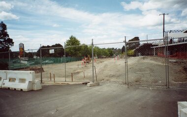
Photograph, Ringwood Railway Precinct circa 2009, demolished buildings all gone on east side on station entrance
... all gone on east side on station entrance ... -
 Ringwood and District Historical Society
Photograph, Ringwood Railway Precinct circa 2009, demolished buildings on east side on entrance
... on east side on entrance ... -
 Ringwood and District Historical Society
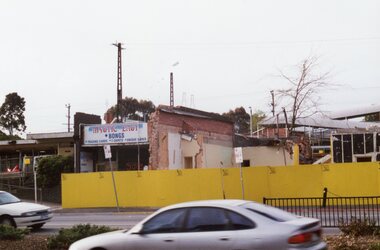
Photograph, Ringwood Railway Precinct circa 2009, shops (including Jimmy's Bar) on east side on station entrance just before demolition
... Jimmy's Bar) on east side on station entrance just before ... -
 Ringwood and District Historical Society
Photograph, Ringwood Railway Precinct circa 2009, shops (including Jimmy's Bar) on east side on station entrance just before demolition
... Jimmy's Bar) on east side on station entrance just before ... -
 Ringwood and District Historical Society
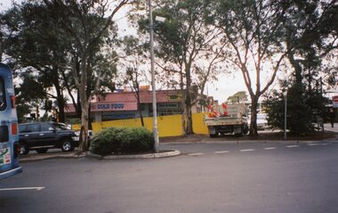
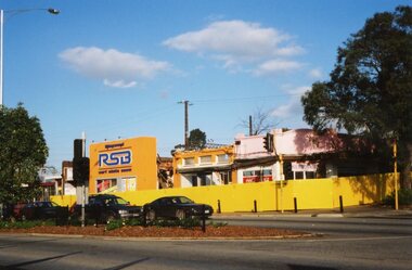
Photograph, Ringwood Railway Precinct circa 2009, shops on east side on station entrance just before demolition
... Ringwood Railway Precinct circa 2009, shops on east side on ... -
 Dandenong/Cranbourne RSL Sub Branch
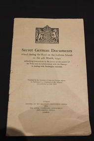
Book, His Majesty's Stationary Office for the Royal Norwegian Government Office, Secret German Documents seized during the raid on the Lofoten Islands on the 4th March, 1941, 1941
... Secret German Documents seized during the raid on the ...WWII Historical significance.Book containing German orders for the treatment of Norwegian Civilians during WWII.Embodying instructions to the Army on the control of the press and on collaboration with the Gestapo in dealing with Norwegian nationals. -
 Ringwood and District Historical Society
Photograph, Ringwood Street looking south-west, Ringwood on 21 April 2009. Former Post Office on right
... Ringwood Street looking south-west, Ringwood on 21 April ...Ron Brons photographic study of Ringwood -
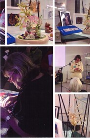 Whitehorse Historical Society Inc.
Photograph - Five photographs on one, WHS Meeting on 11/8/2018. Speaker Vicki Jones Evans on lacemaking
... WHS Meeting on 11/8/2018. Speaker Vicki Jones Evans on ...Five coloured photographs from the WHS Meeting 11/8/2018whs meeting 11/8/2018, speaker vicki jones evans, lacemaking -
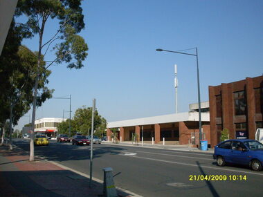
 Ringwood and District Historical Society
Photograph, Looking south south-west on Maroondah Highway, on 21 April 2009, showing bus terminus entrance
... Looking south south-west on Maroondah Highway, on 21 April ...Ron Brons photographic study of Ringwood. -
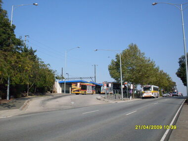
 Ringwood and District Historical Society
Photograph, Looking south south-west on Maroondah Highway, on 21 April 2009, showing bus terminus entrance
... Looking south south-west on Maroondah Highway, on 21 April ...Ron Brons photographic study of Ringwood. -
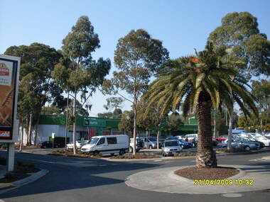
 Ringwood and District Historical Society
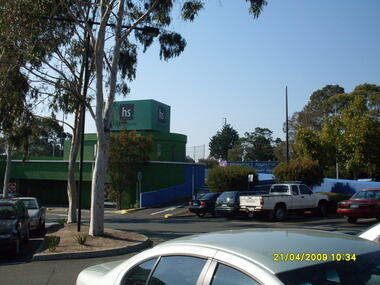
Photograph, Looking across stage 4 Eastland carpark, towards the south-east, on 21 April 2009. Showing entrance to upper carpark on top of Harris Scarfe
... -east, on 21 April 2009. Showing entrance to upper carpark on ...Ron Brons photographic study of Ringwood. -
 Ringwood and District Historical Society
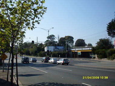
Photograph, Looking east along Maroondah Highway with Warrandyte Road underpass on right, on 21 April 2009
... underpass on right, on 21 April 2009. ...Ron Brons photographic study of Ringwood. -
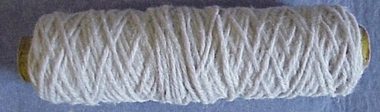 National Wool Museum
Yarn
Off-white wool yarn, possibly from the batch used to make the black and white National Wool Museum rug presented to Queen Elizabeth II in 1988.Off-white wool yarn, possibly from the batch used to make the black and white National Wool Museum rug presented to Queen Elizabeth II in 1988.weaving, spinning -
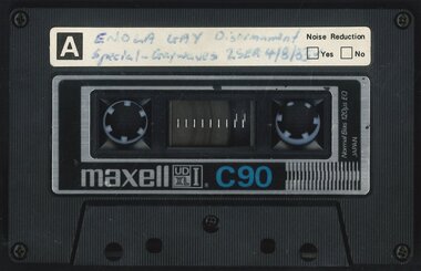 Australian Queer Archives
Audio, 2SER 107.3 FM (Radio Station : Sydney, NSW) : Gaywaves : 4/8/1983 : Enola Gay special on disarmament, 1983
... /8/1983 : Enola Gay special on disarmament ...Produced for Enola Gay's participation in Hiroshima Day, Sat 6 August 1983, assembling at Belmore Park at 10 am under the Enola Gay banners. 0:00: Introduction and song; 3:50: Japanese instrumental music; 9:08: Commentary resumes - history of the bombing of Hiroshima, 6 Aug 1945, and Nagasaki 3 days later; 15:30: Music Tomorrow never comes until it's too late; 19:45: Commentary including accounts from survivors; 26:58: Music, Take the toys from the boys; 29:25: Commentary regarding arms race, including voice of Fabian LoSchiavo regarding dissident religious views in the USA; 33:05: Music, California dreaming; 36:10: Commentary re the practicalities of bomb shelters; 38:00: Music, Cancer, cancer; 41:40: Commentary re peace marches in Europe, health effects of radiation, civil defense in nuclear war, music; 47:35: Music, Universal soldier (cut off towards end), anti-war parody of Yankee Doodle Uncle Sam with Australian refs (Omega, Pine Gap etc); 59:10: Commentary regarding nuclear bomb testing at Marilinga (SA) and Monte Bello islands; 1:01:15: Music, 'But I aint a marchin' any more'; 1:04:05: Commentary re costs of arms race - refs to gay and feminist anti-war groups overseas; 1:05:58: Music, Down by the riverside/Aint gonna study war no more, promo for Enola Gay and prep for Hiroshima Day, instrumental music, music US forces (Midnight Oil), Soft touch (Poison Girls); 1:26:56: Music, Thank Christ for the bomb, eerie instrumental music, Maralinga (Midnight Oil), Not another bomb song, ending at 1:39:00.Maxwell UD XL I - C90 cassette tapeInscribed in biro on label: "ENOLA GAY Disarmament Special - Gaywaves 2SER 4/8/83."anti-nuclear activism, gay and lesbian activism, hiroshima day -
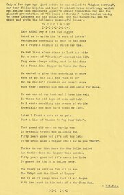 Melbourne Legacy
Document - Poem, Fifty Years On. A Reflection by Brian. Supplement to the Melbourne Legacy Bulletin No 2340 26.9.1978
... Fifty Years On. A Reflection by Brian. Supplement to the ...An article from a supplement to the Bulletin with a poem by Legatee Brian Armstrong written just before he passed away. It reflects on Foundation Day and the first 50 years of Service certificates that were being awarded. Legatee Armstrong had been president in 1937. The prom was called Accolade. Last Anzac Day a fine old Digger / Asked me to write him 'a sort of a letter' / Mentioning something of what he had done / As a private soldier in World War One. He had lived alone since he lost he wife / But a score of 'Grandies' adorned his life / They were always asking what he had done / As a Front Line Digger in World War One. He wanted to give them something to show / When he got his call and 'had to go' / But he couldn't remember and wasn't sure / When they fingered his medal and asked for more. He was one of our best and I knew him well / In those far off days of pain and hell / So I wrote recalling his scenes of strife / Especially one when he'd saved my life. Later I found a note at my gate / Just a line of thanks to 'my Dear Mate'. That grand old word so hardly won / In freezing trench and blinding sun / Fifty years gone but it's not too late / To be proud when a Digger still calls you Mate. Thrice in our time have the War Bells tolled / And thrice does the Legacy tale unfold. Fifty years gone but it's never too late / To guard the Kin of a fallen mate. The story is written for all to see / The 'Why' and the 'How' of Legacy / But it still rings true that it all began / With the trust in his mate of a War-Torn Man. The article was part of an album of past presidents from 1965 to 1989. The folder included biographical details and obituaries, eulogies and death notices of prominent Legatees. The items have been catalogued separately.A record of a poem made by Legatee Brian Armstrong a past president of Legacy about the mateship of Legacy. The information was collected to record the lives of prominent legatees in a folder.Yellow page from Bulletin with a poem by Legatee Brian Armstrong in 1978.Bulletin No 2430 26.9.1978past presidents, foundation day, brian amstrong, poem -
 Eltham District Historical Society Inc
Photograph, Tess Justine (Nillumbik Shire Council), Construction work on replacement of Murray's Bridge over the Diamond Creek, Eltham North, 31 Mar 2022
... Construction work on replacement of Murray's Bridge over ...Construction work on replacement of Murray's Bridge over the Diamond Creek on the Diamond Creek Trail Mary (Sweeney) Murray and John Wright Murray selected 80 acres, Lot C Section 16 and Lot 5 Section 17 Parish of Nillumbik, under an occupation license in 1866. John died in 1867 and freehold was granted to his son John in 1873. The farm was known as ‘Laurel Hill’. John Junior was an Eltham Shire councillor and sometime president from 1887 up until 1897. He added Lot A Section 16 to the farm in ca1888. John and his younger brother James arranged to rent/purchase Lot B Section 17, across Diamond Creek to the west, in ca1900. It appears that John and James farmed separately for a few years, with a new homestead built for James ad family on the high point of Lot B Section 17 in ca1910. John sold off Lot 5 Section 17 in 1912. When John died in 1912 James took over the land on both sides of the Diamond Creek. The old homestead on the west side of the Creek disappeared. A farm bridge over Diamond Creek from this period may have been located close to the northern boundary of the farm. John Langlands, owner of the farm known as ‘Ihurst’ on the west side of Diamond Creek to the south of the Murray’s land, died in 1907. In 1909 his land was then subdivided into 100 lots to become the ‘Glen Park Estate’. Other similar subdivisions of nineteenth century farms around Eltham in this period included the ‘Franktonia (or Beard’s) Estate’ to the northeast and ‘Bonsack’s Estate’ between Eltham and Greensborough. Soon after the opening of the railway extension line from Eltham to Hurstbridge in 1912, Glen Park and nearby residents including James Murray agitated for a railway station or siding to be located half-way between Eltham and Hurstbridge, so that the Glen Park residents who used the railway daily did not have to walk into the Eltham or Hurstbridge stations. Some believed Coleman’s Corner (opposite Edendale Farm) was an appropriate spot for the platform. James Murray was among those who thought the railway should be located on his land, closer to half-way between Eltham and Hurstbridge stations. The Railways Commissioners warned that the locals would have to fund these works themselves. The Glen Park Estate residents initially had difficulty accessing Eltham by road, with only an old low-level bridge over Diamond Creek at the south end of their estate. A new timber trestle bridge across the creek, now on Wattletree Road, was opened in 1915. Road access to the north was gained in 1927 when the new Murray’s Road, which crossed the Murray’s land, was built. Residents continued to agitate for a Glen Park station. By 1926 the Railways Commissioners’ preferred site was on the Murray’s land. They arranged an estimate of cost of a full-length platform. The estimate was too much for the locals, who in 1928 argued unsuccessfully for a shorter and hence cheaper platform. By 1929 Murray had agreed to donate the land, but the locals would still have to fund the works. Murray decided, unilaterally it would appear, to commence work on a timber trestle road bridge over Diamond Creek to link the new Murray Road to the proposed station. Late in 1929 he stopped work on the bridge, for reasons unknown, but started work again and completed the bridge in 1931. There is no further newspaper evidence of the campaign for the Glen Park station until 1939, when Murray and another local, Mr Maxwell, met the Railways Commissioner. The Glen Park locale now included 45 homes on the west side of the creek and 20 on the Eltham side. Most of the residents used the train every day. The Commissioner remained adamant that only a full-length platform could be built for safety reasons. It appears the campaign dissolved at this point. The increasing move to cars may have had an impact. There is no evidence of Murray’s bridge ever being connected to Murray’s Road, or of it having wide use for any purpose by locals. James Murray died in 1947 and the farm was taken over by his son James (Jim). Jim started to sell off parts of the farm in the 1980s, retaining a few acres around the ca1910 homestead and building a new house there. Recreation reserves were established along the creek. In ca1990 Murray’s bridge was renovated with steel girders as part of a bike/pedestrian path in the reserve. The old farmhouse was demolished in ca2014. Born digital image (5)diamond creek (creek), diamond creek trail, murrays bridge, ‘laurel hill’, john wright murray, mary (sweeney) murra, john murray jnr, james murray, john langlands, ‘ihurst’, ‘glen park estate’, beard's estate, franktonia, bonsack's estate, glen park estate, glen park railway station -
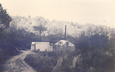 Lakes Entrance Historical Society
Photograph, Oil dehydration plant, Lakes Entrance Victoria, 1930 c
Oil water emulsion was fed into concrete vats where up to 95 percent of water was drained off plant situated at end of track to Midwest No 1 boreBlack and white photograph showing the dehydration plant which separated the oil from original emulsion sityuated in the gully east of Capes Road off Myer Street Lakes Entrance Victoriaoil and gas industry, engineering, social -
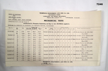 Bendigo Military Museum
Document - MECHANICAL TEST RESULTS, Thompson's Engineering and Pipe Works, 1942
By referring to Cat No 7237.2 will bring up all items associated with Thompsons.Single sheet of paper. Tests on material for 150 Breech blocks for QF 17 PDR Guns. From: Thompson's Engineering & Pipe Co. Ltd. dated 19/10/1942. To: Ministry of Munitions A/C Ordnance Factory Maribyrnong. The tests cover Breech Blocks. (1508 - 1513) (1542 - 1547) (1554 - 1559) (1560 - 1565) (1571 - 1575) (1582 - 1587) Signed off at bottom by (??) Martin.17 pdr a/tn gun, steel testing, ww2 -
 Glenelg Shire Council Cultural Collection
Plan - Ship Plan / Mould, n.d
Wooden pattern for mould for boat fitting. 8 pointed 'star' shape, around a cylinder, which protrudes further on front than back. Painted khaki.Back: '20 OFF' - biro -
Queenscliffe Maritime Museum
Equipment - Underwater video camera, Copy of invitation to placement of underwater plaque commemoration for Harold Holt
Graham McDonald dived from 1940s to 1970s and he used the camera to record his diving experiences. He was invited to film the dedication of an underwater plaque in memory of the late P.M. Harold HoltEarly camera with handmade underwater casing, Invitation to commemoration of plaque to Harold Holt placed underwater.Underwater video camera in handmade aluminium waterproof casing Circa 1968. Copy of invitation to Harold Holt Commemoration plaque underwater placement off, on - on top of camera casecamera, underwater camera, camera casing, harold holt, comemoration -
 Kew Historical Society Inc
Photograph, Marnie McLeod, Floods on the River Yarra at Kew, 1916
... Floods on the River Yarra at Kew ...The donation was accompanied by the following letter from the donor: "Hi. I found these in with family photos. Taken by family as Mamie McLeod was living in Fellows Street, Kew, so would be near there. Retain (or discard) as you see fit." [Donor's name and address withheld from public view]. To gain an insight into the flood levels at Kew, it is worth reading newspaper accounts of the event. The Age published an article - Valuable Gardens Destroyed at Kew - on 25 September 1916: "VALUABLE GARDENS DESTROYED AT KEW. From the heights of Studley Park, Kew, a splendid view of the flood waters can be obtained, and yesterday afternoon, despite continuous rain, crowds of citizens assembled there to witness the spectacle. There is a vast stretch of water some 300 or 400 yards broad, above the foot bridge connecting Gipps-street, Collingwood, and Studley Park. The river is only about 3 feet from the top of the embankment connecting with the ramp of the bridge on the Studiey Park side. When the upper llood waters come down it is almost a certainty that tne embankment will be submerged and the bridge rendered impassible. Below the bridge the waters again stretch out, and have submerged all the low-lying land on the Collingwood side and invaded the back premises ot the Kodak Co., Phoenix Biscuit Factory, a tannery adjoining thereto, the Shamrock Brewery, and Chinese gardens in the vicinity. At Walmer-street-bridge, at the end of Studley Park, the low-lying land on the Kew side is covered with water to the depth of many feet. Tlie land in question is owned in a great part by Mr Frank Lavers who haa gone in for intense culture on a pretty liberal scale on both the slopes of the hill and on the river flat. On the latter he is cultivating many acres of asparagus, and has at a considerable cost spent three years in preparing the ground and installing an irrigation system, reticulated from the Yan Yean water supply. This year the asparagus was put down, and the plants were in a promising condition. Tlie flood waters are now flowing fast over the land. The crop is ruined, and three years' work and expenditure destroyed. Mr. Laver's private residence fortunately is high above flood level, but two houses he owns off Young-street have been flooded out. Having been warned in time, the tenants removed their furniture hefore the water came down to Mr. Laver's residence, where they themselves have been given accommodation in the meantime. All the river flats in East Kew are under water. One or two low-lying houses have been flooded. Chipperfield's boat shed at Willsmere is nearly covered, and some Chinese gardens in the vicinity are several feet under water."This, and the other three photographs donated of floods in Kew are believed to be the earliest in the collection. Together with our original MMBW River Yarra map showing flood levels, these items, when compared allow researchers to gain a visual perspective of the extent of the flood in 1916. Panoramic view, believed to be looking north towards Fairfield from the Zig-Zag Bridge on the River Yarra. The inscription on the reverese identifies it as taken before 1920.Inscription on reverse in ink "(pre 1920) Flood from Zig-zag bridge Yarra River, Kew Vic."river yarra, kew, floods 1916, zig-zag bridge