Showing 142778 items matching "photograph-oliver-glen-douglas-orbost"
-
 Orbost & District Historical Society
article, William Morris
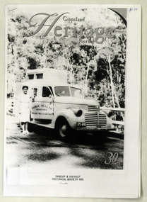
GHJ is a journal, produced about every nine - twelve months, for those interested in regional, local and family history in Gippsland, Victoria, Australia. It is compiled by Meredith Fletcher, Debbie Squires and Linda Barraclough and includes a diverse range of articles, both academic and non-academic. Since No.24 it has been a partially refereed journal.(ref kapana)This is a useful research article.A 4 pp article copied from Gippsland Heritage Journal No 30, William Morris on the Threshold of Gipps' Land. The author is Annette Peisley.morris-william genoa-history -
 Orbost & District Historical Society
folder of documents, 1970
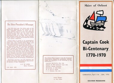
Events held included a supper dance, an angling competition, a gymkhana, a street parade, an art show, a garden competition, a historical display, tree planting and a ceremony at Point Hicks. This item is associated with a significant event in Australian history.A manila folder of documents related to the 1970 Captain Cook centenary celebrations . It contains souvenir programs and details of events held from April 11 to April 20th 1970.cook-james 1970-centenary orbost-shire-council -
 Tarnagulla History Archive
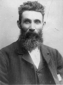
Photographs: John Douglas of Laanecoorie, John Douglas of Laanecoorie, circa 1900
Murray Comrie Collection.Two copies of a monochrome photograph, image depicting a bearded man in a suit. Accompanying note identifies sitter as John Douglas of Rosemont homestead at Laanecoorie, Victoria. This is a slightly dark copy of an older original. Copy probably made by Murray Comrie in the 1960s.laanecoorie, rosemont, douglas, farms -
 Orbost & District Historical Society
black and white photograph, Warren, Mrs H, first half 20th century
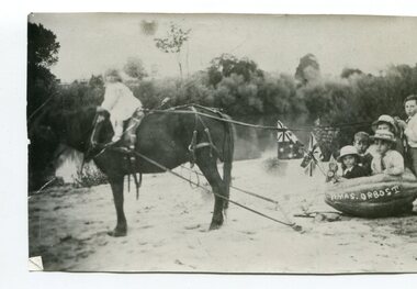
The photograph shows Linda Warren, Enid Eaton, Jim Trewin and Jim Nixon. The photographer was Warren, Helena (1871-1962) who was a self-taught photographer who became both the local press correspondent and a producer of humorous trompe l'oeil postcard images. Helena Warren was a thirty-two year old settler living on a small mixed farm with her husband, William, at Newmerella, near Orbost in Gippsland, Victoria, when she bought her first camera, an Austral Box quarter-plate. Her family says she was entirely self-taught, like many women photographers who started out with nothing but the instructions on the packets of film and chemicals. In over fifty years practice she graduated from the total novice, who opened all her first mail order plates in bright sunlight and ruined them, to a competent photographer who became both the local press correspondent and an inveterate producer of humorous trompe l’oeil postcard images. Helena Francis Warren (nee McKeown) was married to William John Warren and lived in Newmerella. She supplied the photos for the Back-To-Orbost celebration book in 1937 and also designed the Back-To-Orbost badge. She was known for her soft toy making. (by Ivy Rodwell in from Personalities and Stories of the Early Orbost District by Mary Gilbert). This photograph has significance in its association with Helen Frances Warren, a popular Orbost identity who was well known as an accomplished photographer and needleworker,A black / white photograph of a young girl on a horse pulling a group of children in a large pumkin. On the side of the pumpkin is "HMAS ORBOST"pumpkins-orbost warren-helena nixon-jim trewin-jim warren-linda eaton-enid -
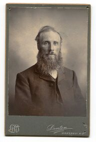 Orbost & District Historical Society
black and white photograph, Denton, Frank James, 1894 -1904
Reverend Alexander Morton was the Presbyterian minister in Orbost between 1894 and 1904. Rev. Alexander Morton earned great respect from the Orbost community, during his ministry here between 1894-1904. He brought with him from the New Hebrides timber which was used for the pulpit. Affectionately known as “Sandy” Morton, he was very friendly and endeavoured to reach all his bush parishioners, often on horseback. He was known up the Gelantipy Valley as an itinerant Preacher with a difference, he often doubled as a dentist, who was quite adept at pulling teeth, often with a pair of pliers. ( information from Margaret Smith Newsletter August 2012)Reverend Alexander Morton was a prominent Orbost citizen in the late 19th - early 20th centuries. He was associated with the Presbyterian Church in Orbost.A black / white portrait photograph on a dark grey buff card. It is a head and shoulders posed photograph of a bearded man in a suit.on back - Rev. Alex Morton, Presbyterian Minister at Orbost"morton-alexander presbyterian-church-orbost -
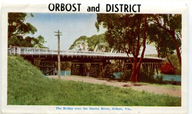 Orbost & District Historical Society
postcard series, 1960s
Included are photographs of the Orbost township, the Snowy River at Marlo, Gypsy Point, Buchan Caves and Bairnsdale. In the 1960s Orbost had a population of 4000 and was a major tourist attraction in Eastern Victoria with sufficient accommodation and facilities. It was the major town close to several national parks with access to either the surf or the snow. These postcards are pictorial records of Orbost in the 1960s. Postcards are very interesting records of places. architecture and transport.A colour postcard series with photographs of Orbost and the district. The cover photograph is of the Snowy River Bridge. There is an information card.Each photograph is labelled. at the bottom.postcards-orbost postcards-east-gippsland -
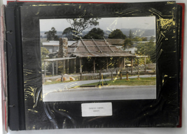 Orbost & District Historical Society
albums, late 1980's
These two albums were used at the Slab Hut - Orbost Visitor Information Centre. The Orbost Visitor Information Centre is situated in Forest Park on Nicholson Street. The centre is housed in the historic Slab Hut. The hut was an original family dwelling built in 1872, on a site approximately three kilometres upstream from the junction of the Buchan and Snowy Rivers. No nails were used in the construction; it was all wired together. After a period in storage the slab hut was opened in its present location in Orbost as the Information Centre in 1987.These albums are contemporary records of the construction and relocation of an iconic Orbost building, the Slab Hut.Two large photo albums. 2280.1 has no front cover. The back cover and spine are red. The pages are black and most photos are labelled. They are photographs of the Orbost area. 2280.2 has brown covers. It contains photographs of the construction of the gardens and buildings around the Slab Hut (Orbost Visitor Information Centre). On the cover in gold print is "PHOTOS".slab-hut-orbost album-photographs-orbost -
 Camberwell Historical Society
Booklet (Item), Gwen McWilliam, Early Glen Iris, 1971
glen iris -
Moorabbin Air Museum
Manual - Douglas aircraft, Douglas Service Magazine 1965
Descriptive & maintenance notes, including spare parts schedule, circa 1965non-fictionDescriptive & maintenance notes, including spare parts schedule, circa 1965non return valves, anticer pumps., relay valve control for pneumatic brakes, tail wheel, griffon engine fuel injector pumps, l type cartridge starter -
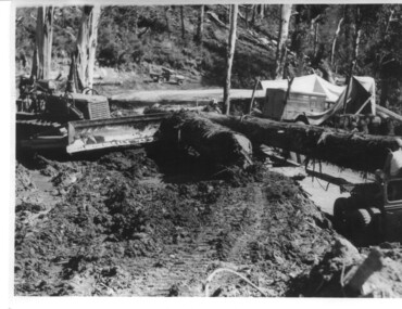 Kiewa Valley Historical Society
Photograph, logging at McKay Creek, Logging at McKay Creek, c1950's
This photograph was probably taken at the site of McKay Creek Power Station. Excavation of this site did not commence until 1951 but road access(a narrow track) was provided in 1948 and widened in 1954. The logs would have been milled for timber at the State Electricity Commission's mill at Howman's Gap and thus provided a much needed source of timber for construction of camps and houses as there was a general of shortage of this commodity. Because of trouble with landslides in this area, a decision was made to place the machine hall of the power station underground instead of on the surface. Restricted financial resources and the repositioning of the power station retarded construction activities and it was not completed until early 1961.. An excellent pictorial record of the general working conditions, type of machinery and vehicles in use in the 1950/s.Black and white photograph showing logging equipment, fallen logs.Handwritten on the back of the photograph "Logging at McKay Creek)logging, mckay creek, timber, machinery -
 Orbost & District Historical Society
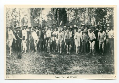
black and white photograph, 1890
A sports carnival was held annually in Orbost from the late 19th century onward. Usually the carnivals raised money for worthy local causes.Closer to the date, a program of events was published, including the prizes on offer and entries invited for the footrace and woodchop events, as nomination and acceptance fees applied. Entries for other events were taken on the day. The Sports Day would end with a concert in the evening. (info. Jenni York)This is a pictorial record of a significant annual event in the late 19th century in Orbost.A black / white photograph of a group of men wearing athletic clothing ready for a foot race. There is a large group of supporters standing behind them.on front - "Sports Day at Orbost"recreation orbost-sports day athletics foot-racing carnival -
Moorabbin Air Museum
Manual (item) - Douglas DC-9 Illustrated Parts Catalogue
Douglas Aircraft Co.Inc -
Moorabbin Air Museum
Manual (item) - Douglas DC-9 Illustrated Parts Catalogue, Douglas DC-4 Illustrated Parts Catalog
Douglas Aircraft Co.Inc -
Moorabbin Air Museum
Manual (item) - Douglas DC-9 Illustrated Parts Catalogue
Douglas Aircraft Co.Inc. -
Moorabbin Air Museum
Manual (item) - Douglas C-47 Maintenance Manuals, Untitled - Douglas C47 Maintenance Document
Douglas Aircraft Co.Ltd. -
Moorabbin Air Museum
Manual (item) - Douglas DC-6 Operations Manuals, Douglas Service DC-6 Air Conditioning System Operation for Flight Crews
Douglas Aircraft Co.Ltd. -
Moorabbin Air Museum
Magazine (Item) - Douglas Service Magazine - DC8/ DC9, Douglas Service 1974 DC8/DC9 Maintenance-Engineering Conference
Douglas Aircraft Co.Inc. -
Moorabbin Air Museum
Manual - Douglas C-47 graviscope, The Graviscope for Douglas C47 Aircraft
Overview of Graviscope & its operation, used to determine gross weight of aircraft, circa 1944Small, thin manualnon-fictionOverview of Graviscope & its operation, used to determine gross weight of aircraft, circa 1944c47 graviscope -
 Orbost & District Historical Society
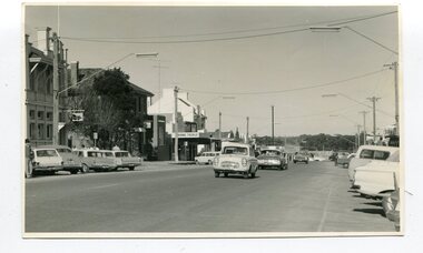
black and white photographs, 1960s - 1970s
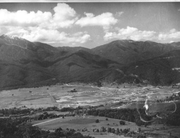
3289.1 has been taken in the main street of Orbost - Nicholson Street. 3289.2 has been taken on the outskirts of Orbost and indicates that the town population at the time was 2800.These photographs are pictorial record of Orbost C1960s - 1970s.3289.1 is a black / white photograph of a main street with cars parked on both sides of the road and buildings on the left hand side. 3289.2 is a black / white photograph of town entry sign - "ORBOST POP. 2800".orbost-nicholson-street main-street-orbost entry-sign-orbost orbost-1960s-1970s -
 Orbost & District Historical Society
black and white photographs, second half 20th century
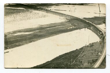
3154.1 is a postcard of the Orbost viaduct over the flooded Snowy River flats. 4153.2 is of a goods train on the viaduct. 3154.3 is of a loaded goods train with the driver at the window. Two men are standing on the plate and there are two workers below where there is some water and flood debris. 3154.4 is of amachine moving flood debris on the rail line. 3154.5 shows flood damage to the viaduct across the Snowy River flats. Two men are driving a dozer.This item is associated with the history of the Orbost-Bairnsdale railway line and therefore reflects the role that the rail line played in the social and economic history of Orbost.Five black / white photographs associated with the Orbost railway line during a flood.orbost-railway east-gippsland -railway orbost-floods -
 Federation University Historical Collection
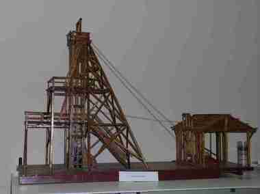
Unknown - Model, Poppet Head Model
This scale model of a mining plant was made by Donald Douglas Mather of Talbot. The engine shed houses the winches, which raise and lower the cages carrying the workmen. The winches also control the water-Baling tanks, which are lowered into the pump shaft to clean the water. The Pump Shaft is part of the main shaft partitioned off for keeping the water down. The old style plant (or cas commonly known poppet legs), were all of timber construction and, when erected, straddled the main shaft. This scale model allows for steel construction, and is set over the shaft to permit an unobstructed view of the operations. The Bad level is where the workmen enter and leave the shaft. The staging platform on the first level is where the trucks and mullock or other material are wheeled out on rails and then tipped to form the mine dump. The top level is to allow for maintenance of plant. Donald Douglas Mather of Talbot worked in mines in Ballarat, and made the model of the poppet head. The poppet head is a replica of those used at many mines in Ballarat. Back in the 1850s Ballarat was a god rush town and many mining claims were made and poppet heads built this is a replica of those poppet heads which are a part of Ballarat's Heritage and a full size poppet head is erected at Sovereign Hill Theme Park in Ballarat. Mining is a huge part of Ballarat's history.A timber poppet head and engine room model. "This scale model - the modern construction of a mining plant - was made by Mr Donald Douglas Mather* of Bonnie Doon, Talbot, Victoria. The engine shed houses the winches, which raise and lower the cages carrying the workmen. The winches also control the water-baling tanks, which are lowered into the pump shaft to clean the water. The pump shaft is part of the main shaft partitioned off for keeping the water down. The old style plant (or as commonly known poppet legs), were all of timber construction and, when erected, straddled the main shaft. this scale model allows for steel construction, ans is set over the shaft to permit an unobstructed view of the operations. The bad level is where the workmen enter and leave the shaft. The staging platform on the first level is where trucks ad mullock or other material are wheeled out on rails and then tipped to form the mine dump. The top level is to allow for maintenance of plant. * Mr Mater, previously of Ballarat, worked for many years as a miner and plant erector" (Old interpretive panel)mining, mather, mining plant, poppet head, engine house, model, donald douglas mather -
 Kiewa Valley Historical Society
Photograph of Mt. Beauty, Mt. Beauty from transmission line, Approx 1950/51
This photo is of the very newly constructed State Electricity Commission town of Mt. Beauty. The houses up to Nelse street were erected from 1946 onward and then the township was extended beyond Nelse Street in 1950 which places this photograph about 1950/51. There is no evidence of work being commenced on the regulating pondage but the tail race canal can be seen on the centre right of photo. The workmen's camp was enlarged in 1950 to the extent of providing accommodation for a total of 1,200. There are a number of dwellings on Simmonds Creek and the road to Falls Creek can clearly be seen. Snow capped Mt. Bogong is in the upper left of the photo with Mt. Beauty behind the township rising to Big Hill beyond that.Shows the newly constructed town of Mt. Beauty surrounded by farmland and before the regulating pondage was built to discharge water from the power stations via the West Kiewa tail race tunnel into the Kiewa River. Black and white photographHand written on back of photograph "Mt. Beauty from Transmission Line"mt. beauty, construction, pondage, state electricity commission -
Moorabbin Air Museum
Magazine (item) - Douglas Aircraft Servicing, Douglas Service
Douglas Aircraft Co Inc. -
Moorabbin Air Museum
Manual (item) - Douglas DC-9 Illustrated Parts Catalogue
Douglas Aircraft Co. Inc -
Moorabbin Air Museum
Magazine (Item) - Douglas Service Magazine - DC10, Douglas Service 1976 DC10 Team Conference
Douglas Aircraft Co. Inc. -
Moorabbin Air Museum
Manual (Item) - McDonnell Douglas DC9 parts lists, Douglas Aircraft Co. DC-9 Illustrated Parts Catalogue - 4 books
Douglas Aircraft Co., Inc. -
Moorabbin Air Museum
Drawing (Item) - Douglas Dolphin A35, drawings, Douglas Dolphin A35
Douglas Aircraft Co., Inc. -
Moorabbin Air Museum
Manual - McDonnell Douglas technical publications, Hole Preparation for Aircraft Fasteners McDonnell Douglas
Overview of hole tolerances for fasteners in aircraft manufacture, circa 1987Manual in book form Overview of hole tolerances for fasteners in aircraft manufacture, circa 1987aircraft fasteners -
 Surrey Hills Historical Society Collection
Photograph, Douglas and Jean Sneddon with Alice Keane, 14 Suffolk Road, Surrey Hills
The property was named 'Cliburn' after Cliburn in Westmorland (later Cumbria) where Mary Sneddon's mother, Mary Bird (nee Coulston) came from. According to the donor all their houses were given this name. William Sneddon (b.1875, Sandhurst - d. 1957, Deepdene) was a postman in Surrey Hills for many years. His father James (1833 - 1901) ran an estate agency in Surrey Hills started in the 1880s by his father, also James. William's wife was Mary Sneddon, nee Bird, (b. 1878 Bethunga; d. 1948, Surrey Hills); they married in Surrey Hills in James Sneddon's house on 12 November 1903. They had 5 sons and 1 daughter: John William 'Jack' Sneddon (b.1908 - d. 1957); married Mabel Creek. Norman Alexander Sneddon (b. 1910 - d 1989); married Eva Pearl Sampson. Alan Coulston Sneddon (b. 1914 - d. 1985); married Netta May Clow in 1941. Jean Isobel Sneddon (b. 1916 - d. 1976); married Clifford James Jenkin. Douglas Haig Sneddon (b.1918, Surrey Hills - d. 1973, Blackburn); married Myra Marjorie Clewett in 1945. Relationship with Alice Keane: According to the donor, Alice Ruby Dore married Herbert Keane. She was born 21/9/1901 and died 14/4/1926. Her entries in the Victorian BDM index give that her father was Henry Dore and her mother Sarah Ann Bird and that she was born in Neerim. She married Herbert Henry Keane in 1922; her death at the age of 24 years was registered in Heidelberg. According to the donor her young children Wallace and Phyllis were embraced by William and Mary Sneddon. William and Mary Sneddon are buried in Box Hill Cemetery. The donor Robin da Costa-Adams is related by her first marriage to the Sneddon family. Relationship with Bird family: Netta Sneddon was correct in that Alice Keane was likely a relative. The exact relationship is yet to be fully established. Alice's mother's name is given as Sarah Ann Bird (1873-1952) with birth at Tarrawingee; father John Bird and mother Sarah Ann Coburn (REF: Victorian BDM index). Her notice of marriage in The Age in 1894 states she is "the eldest dau of John Bird of Drouin, late of Box Hill and Talgarno." Has her mother's surname been misspelt? Is it Coulston? Sepia photo of Douglas Sneddon and his sister Jean Sneddon taken in the garden of 'Cliburn', the home of their parents William and Mary Sneddon. With them is with Alice Keane. Part of the house is seen on the RHS of the photo. It is an Edwardian timber home. The profile of the house next door can also be seen in the background."Alice Keane / at / Doug & Jean Sneddon / taken at Sneddons / Surrey Hills" in grey lead pencil in Robin da Costa-Adams' writing. "Children of Mary & / William" "An Alice Keane may be an Aunt (crossing out) - Netta / was not sure" in ink in Jocelyn Hall's hand.suffolk road, 'cliburn', jean isobel sneddon, mrs jean isobel jenkin, douglas haig sneddon, william sneddon, miss mary bird, mrs mary sneddon, box hill cemetery, children, clothing and dress, mrs alice keane, mrs alice ruby keane, miss alice ruby dore -
 Orbost & District Historical Society
black and white photograph, C1900
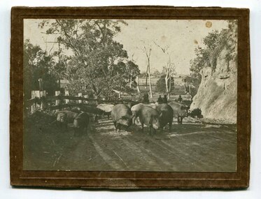
Pigs were taken to Bairnsdale by coaxing them with maize thrown from a wagonette . From Bairnsdale they were freighted to market by train. The journey to Bairnsdale took about five days . This method of transport continued until the rail line to Orbost was opened in 1916.This photograph is a pictorial record of farming practices in the early 20th century.A black / white photograph on a brown buff card showing pigs being taken to market. The photograph shows the pigs close up with men on horseback behind them. The pigs are on a gravel road with a fence on one side and and the Orbost flats can be seen in the background.on back - "Pigs being driven from Orbost to Bairnsdale. M.Gilbert, Orbost"agriculture farming-orbost pigs