Showing 1266 items matching "recent"
-
 Eltham District Historical Society Inc
Photograph, Liz Pidgeon, Heritage Excursion; East of Eltham, 6 Sep 2014, 20 May 2017
Newsletter No. 218, September 2014 September Excursion - East of Eltham Walk In Newsletter No. 197, March 2011, there was a brief history of Crown Allotment 15 Section 5 Parish of Nillumbik (CA 15) a parcel of land of a quarter of a square mile extending from Eucalyptus Road to Reynolds Road at the eastern extremity of Eltham. From the 1940s it was known as Stokes orchard. In later years it has been subdivided for residential purposes but leaving significant areas as power line and water supply reserves and bushland reserves that are habitat for the threatened For our excursion on 6th September we intend to walk through CA 15 to a bushland reserve east of Reynolds Road. The walk will traverse the boundary between suburban Eltham and the non-urban areas to the south and east. This is a pleasant walk through residential areas and bushland. Along the way we will discuss the early and more recent history of CA 15 as well as local natural history and geology. This walk is about 3.5 km in length and will take 2 to 2.5 hours. It will start at 2pm at the corner of Eucalyptus Road, Pitt Street and Nyora Road.Born Digitaleltham east, eltham district historical society, heritage excursion, activities, nyora road, reynolds road, gum tree road reserve, diosma road, stokes orchard, eucalyptus road -
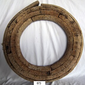
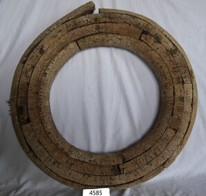
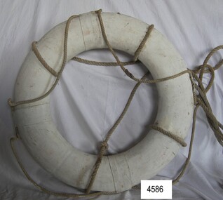
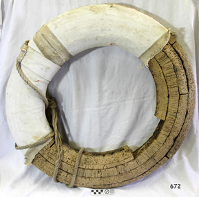 Flagstaff Hill Maritime Museum and Village
Equipment - Lifebuoy, late 19th to early 20th century
This lifebuoy is part of the lifesaving equipment that would be carried on vessels in the late 19th and early 20th century. The strips of cork wood have been joined together to make the ring shape. A lifebuoy, or life-preserver, is used as a buoyancy device to keep a person afloat in the. It is usually connected by a rope to a person in a safe area such a nearby vessel or on shore. The lifebuoy is thrown to a person in distress in the water, allowing the rescuer to pull the person to safety. The lifebuoy is a made from a buoyant material such as cork or rubber and is usually covered with canvas for protection and to make it easy to grip. The first use of life saving devices in recent centuries was by the Nordic people, who used light weight wood or cork blocks to keep afloat. From the early 20th century Kapok fibre was used as a filling for buoys. Light weight balsa wood was used as a filler after WW1. In 1928 Peter Markus invented and patented the first inflatable life-preserver. By WW2 foam was combined with Kapok. Laws were passed over time that has required aeroplanes and water going-vessels to carry life-preservers on board. The lifebuoy is an example of equipment carried on vessels in the late 19th and early 20th century to help preserve life. There were many lives lost in Australia’s colonial period, particularly along the coast of South West Victoria.Lifebuoy, round cork object covered with white stiffened material wound around it. flagstaff hill, warrnambool, shipwrecked-coast, flagstaff-hill, flagstaff-hill-maritime-museum, maritime-museum, shipwreck-coast, flagstaff-hill-maritime-village, lifebuoy, life rings, safety ring, life-saving buoy, ring buoy, life preserver, personal floating device, floatation device, safety equipment -
 Flagstaff Hill Maritime Museum and Village
Equipment - Lifebuoy, late 19th to early 20th century
This lifebuoy is part of the lifesaving equipment that would be carried on vessels in the late 19th and early 20th century. The strips of cork wood have been joined together to make the ring shape. A lifebuoy, or life-preserver, is used as a buoyancy device to keep a person afloat in the. It is usually connected by a rope to a person in a safe area such a nearby vessel or on shore. The lifebuoy is thrown to a person in distress in the water, allowing the rescuer to pull the person to safety. The lifebuoy is a made from a buoyant material such as cork or rubber and is usually covered with canvas for protection and to make it easy to grip. The first use of life saving devices in recent centuries was by the Nordic people, who used light weight wood or cork blocks to keep afloat. From the early 20th century Kapok fibre was used as a filling for buoys. Light weight balsa wood was used as a filler after WW1. In 1928 Peter Markus invented and patented the first inflatable life-preserver. By WW2 foam was combined with Kapok. Laws were passed over time that has required aeroplanes and water going-vessels to carry life-preservers on board. The lifebuoy is an example of equipment carried on vessels in the late 19th and early 20th century to help preserve life. There were many lives lost in Australia’s colonial period, particularly along the coast of South West Victoria.Lifebuoy, round cork object with no covering. flagstaff hill, warrnambool, shipwrecked-coast, flagstaff-hill, flagstaff-hill-maritime-museum, maritime-museum, shipwreck-coast, flagstaff-hill-maritime-village, life rings, lifebuoy, safety ring, life-saving buoy, ring buoy, life preserver, personal floating device, floatation device, safety equipment -
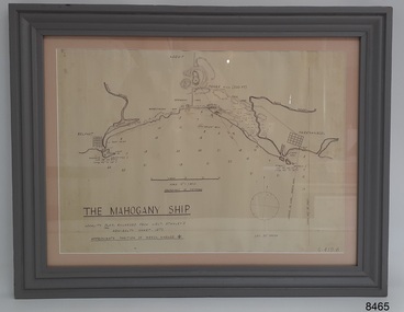 Flagstaff Hill Maritime Museum and Village
Document - Location Chart, The Mahogany Ship, 2007
This chart shows a possible site for the fabled wreck called the 'Mahogany Ship'. Flagstaff Hill’s collection includes other objects that some say could be relics from this Ancient Wreck, (also called the Gold Ship, or the Ancient Vessel). The chart shows the coordinates for the Summits of Griffith Island and of Middle Island. It also has the depths of the sea at various intervals and shows the shore and sand dunes, lighthouses and other reference points. The mystery of the Mahogany Ship began in 1836 when two shipwrecked sealers discovered the remains of an “ancient vessel” in the sand dunes about four miles west of Warrnambool. Since the last recorded sightings in the 1880’s the true origin of the Mahogany Ship has remained one of Australia’s most famous historical mysteries or fables. One of the more recent theories is that the vessel was one of the Portuguese ships exploring the Australian coast in 1522. For over one hundred years searchers have attempted to locate and identify the wreck. The search continues for the tangible evidence which will once and for all establish the Mahogany Ship’s place in Australia’s History.The chart represents the worldwide interest in locating the wreck of the Mahogany Ship. Locating the actual wreck or proving the existence of a Portuguese ship's wreck could change the history of the discovery of Australia. A Mahogany Ship committee was formed to gather and research information about the discovery of the wrecked ship. A large amount of money was offered as a prize for finding the wreck or parts of it. People have written books, painted images, made videos and told tales of the ship but it continues to remain a mystery or even a fable. The chart is significant for its possible link to one of Victoria’s and Australia’s maritime mysteries, the Mahogany Ship (also known as the Ancient Wreck). It is one of very few known relics that could give evidence of the existence and history of the vessel. It is listed on the Victorian Heritage Register S438 as it is one of Victoria’s oldest recorded shipwrecks. The identity of the vessel has the potential to change Australia’s history.A chart in a wooden frame, behind glass. The chart shows the approximate position of the mystery Ancient Wreck, later called the "Mahogany Ship". The chart is a copy and is based on the Admiralty Chart by Lieut. Stanley, dated 1872. Lower left: "THE MAHOGANY SHIP" "LOCALITY PLAN, ENLARGED FROM LIEUT. STANLEY'S ADMIRALTY CHART 1872" "APPROXIMATE POSITION OF WRECK MARKED [symbol of a Portuguese cross]" Other labels on chart: "BELFAST" "PORT FIARY" "GRIFFITHS I" "RIVER MOYNE" "RIVER MERRI" "ARMSTRONG BAY" " GORMANS LANE" "TOWER HILL" "KOROIT" "HELEN ROCK" "WARRNAMBOOL" "LADY BAY" "MIDDLE I" "LIGHT HO." Lower right: "G 410 B" Label on the back; "This chart presented to the Mahogany Ship Committee and Flagstaff Hill by Avis Quarrell, April 2007"warrnambool, shipwrecked coast, flagstaff hill maritime museum, shipwreck coast, mahogany ship, ancient vessel, ancient wreck, portuguese ship, coastal reserve, fabled wreck, gold ship, griffiths island, belfast (now port fairy), koroit, location plan, leuit. stanley, admiralty chart 1872, tower hill, merri river, moyne river, middle island, helen rock, armstrong bay, griffiths land -
 Glen Eira Historical Society
Article - ELSTER AVENUE, 16, ELSTERNWICK
This file contains 6 items: 1/Handwritten notes by Peta Darke dated 25/07/2014 listing title details for 16 Elster Avenue from 1909 to 2009 – two pages. 2/Handwritten list of Sands and McDougall entries for the property from 1915 to 1940 dated 25/07/2014 compiled by Peta Darke. 3/A photocopy of a Biggin Scott Real Estate Agents flyer advertising the recent sale of the property in 2009. 4/Print out from ‘The Argus’ of 04/12/1917, Page 6, from the Trove website of a brief article concerning the wounding of S.P.Jones, son of Stephen Jones of ‘Mons’, Elster Avenue in November 1917. 5/A photocopy of colour photograph of exterior of 16 Elster Avenue Circa 1998 taken by R.Darke. 6/Article from ‘Caulfield Glen Eira Leader’ of 25/03/2014, Page 3, concerning Oscar Jones, 14 year old son of present owners, who is an excellent surf life saver. Includes colour photograph of Oscar.elster avenue, college street, bowood, elsternwick, bowden arthur william, mons, hartington street, parnell street, jones stephen alma, kooyong road, kendall ann bell, kendall james william, kendall harold duncan, morrison harold lindsay, morrison rhonda may, cook jean isobel, golding ida curnow, perrett craig stuart, perrett eileen mary, perrett edward, perrett anthea, perrett catherine, lewis kay margaret, swain anthony barry gilles, swain darcy, swain mitchell, jones adrian, jones karine stehman, jones oscar, jones patrick, thomas lloyd, rickman jacob, lee james t, nidschelm harold, regan francis, jones douglas, laughton martin, biggin and scott, ashton daniel, jones stephen percy douglas, architectural styles, edwardian style, timber houses, gardenvale, collinson william morris, thomson william hamilton, lempriere john thompson -
 Flagstaff Hill Maritime Museum and Village
Equipment - Lifebuoy, late 19th to early 20th century
This lifebuoy is part of the lifesaving equipment that would be carried on vessels in the late 19th and early 20th century. The strips of cork wood have been joined together to make the ring shape. A lifebuoy, or life-preserver, is used as a buoyancy device to keep a person afloat in the. It is usually connected by a rope to a person in a safe area such a nearby vessel or on shore. The lifebuoy is thrown to a person in distress in the water, allowing the rescuer to pull the person to safety. The lifebuoy is a made from a buoyant material such as cork or rubber and is usually covered with canvas for protection and to make it easy to grip. The first use of life saving devices in recent centuries was by the Nordic people, who used light weight wood or cork blocks to keep afloat. From the early 20th century Kapok fibre was used as a filling for buoys. Light weight balsa wood was used as a filler after WW1. In 1928 Peter Markus invented and patented the first inflatable life-preserver. By WW2 foam was combined with Kapok. Laws were passed over time that has required aeroplanes and water going-vessels to carry life-preservers on board. The lifebuoy is an example of equipment carried on vessels in the late 19th and early 20th century to help preserve life. There were many lives lost in Australia’s colonial period, particularly along the coast of South West Victoria.Lifebuoy; round, cork filling of lifebuoy. The nails joining the layers are visible. flagstaff hill, warrnambool, shipwrecked-coast, flagstaff-hill, flagstaff-hill-maritime-museum, maritime-museum, shipwreck-coast, flagstaff-hill-maritime-village, life rings, lifebuoy, safety ring, life-saving buoy, ring buoy, life preserver, personal floating device, floatation device, safety equipment -
 Flagstaff Hill Maritime Museum and Village
Equipment - Lifebuoy, late 19th to early 20th century
This lifebuoy is part of the lifesaving equipment that would be carried on vessels in the late 19th and early 20th century. The strips of cork wood have been joined together to make the ring shape. A lifebuoy, or life-preserver, is used as a buoyancy device to keep a person afloat in the. It is usually connected by a rope to a person in a safe area such a nearby vessel or on shore. The lifebuoy is thrown to a person in distress in the water, allowing the rescuer to pull the person to safety. The lifebuoy is a made from a buoyant material such as cork or rubber and is usually covered with canvas for protection and to make it easy to grip. The first use of life saving devices in recent centuries was by the Nordic people, who used light weight wood or cork blocks to keep afloat. From the early 20th century Kapok fibre was used as a filling for buoys. Light weight balsa wood was used as a filler after WW1. In 1928 Peter Markus invented and patented the first inflatable life-preserver. By WW2 foam was combined with Kapok. Laws were passed over time that has required aeroplanes and water going-vessels to carry life-preservers on board. The lifebuoy is an example of equipment carried on vessels in the late 19th and early 20th century to help preserve life. There were many lives lost in Australia’s colonial period, particularly along the coast of South West Victoria.Lifebuoy, round cork filling inside white canvas cover with four reinforced bands. Four ropes are attached.flagstaff hill, warrnambool, shipwrecked-coast, flagstaff-hill, flagstaff-hill-maritime-museum, maritime-museum, shipwreck-coast, flagstaff-hill-maritime-village, life rings, lifebuoy, safety ring, life-saving buoy, ring buoy, life preserver, personal floating device, floatation device, safety equipment -
 Bendigo Historical Society Inc.
Document - NORMAN OLIVER COLLECTION: MAYOR SPEAKS, UNDATED
The Norman Oliver collection. Norman Oliver was three times Mayor of Bendigo - 1950-51, 1964-65, 1970-71. Three typed pages of speech notes. Undated but information suggests 1965. Corrections made in blue and red ink. Mentions that the Easter Fair has recently ended. Topics discussed : the Cancer Campaign success and recent advances in treatment and facilities, a discussion with a Mr Larritt, the grandson of Bendigo's first surveyor, and the work his grandfather performed, especially regarding the reservations chosen for the Hospital and the Home and Hospital for the Aged, the Art Gallery's Dobell exhibition, Commonwealth Youth Sunday on May 2nd, the promotion of Bendigo by the Victorian Promotion Committee, and Anzac Day business. Oliver states that 'in 1914 the citizens of Bendigo presented the 7th Bn AIF with a set of bugles. One of the bugles used by 'Pompey' Simpson in the landing of Gallipoli and in France until he was wounded in 1917, when it was used by Wally Granland until the Armistice. On Anzac Eve at the 9PM ritual to the Fallen, the bugle will be used for the first time since the first war ..by Bugler John Murphy of Southern Command.' The HMAS Bendigo Assoc. reunion and information.bendigo, council, speech notes, norman joseph oliver , councillor norman oliver. mayor of bendigo. anti-cancer appeal. victorian inland meat authority. anzac day. -
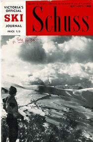 Falls Creek Historical Society
Journal - Schuss Vol. 24. No.7 September - October 1958
Schuss was advertised as Victoria’s Official Ski Journal It was issued monthly from 1935 to 1961 except during the war when summer issues covered two months. This continued after the war, but it averaged 10 issues annually over its 25 year life. Schuss was published by the Ski Club of Victoria which had a membership of 38 Ski Clubs and demanded to be recognised as the prime authority on skiing in the state. The other 30 ski clubs with 85% of the members disagreed and the politics of skiing became heated. These clubs formed the Federation of Victorian Ski Clubs with their own journal, Ski Horizon. With the establishment of the Victorian Ski Association, Ski-Horizon published its last issue in Nov - Dec. 1955 and the role of the official journal was fully taken over by “Schuss”. This item is significant because it contains stories, images and information documenting the development of the ski facilities at Falls Creek.The journal features stories and events chronicling developments in Victoria and internationally. The cover features an Eric Burt photo of the Eastern slopes at Hotham with Feathertop in the distance. Page 293 has a photo of John Robertson of Myrtleford Ski Club who was chosen to lead the Australian Ski Team in New Zealand for the Inter-Dominion Contest in September. Page 296 announced that Mt Beauty was judged as the leading town in Victoria for Tourists in the recent City Development Association's Premier Town Contest. Page 300 included the results of the NEDSA Championship held at Falls Creek in August. Reference is made to the proficiency of Fred Griffith in producing copies of the results for all involved. Page 303 featured the Swiss Cheese Fondue Recipe from the opening of the Ski Club of Victoria Rooms as requested. It also included an article "A week at Sky Line" written by Junior Member Keith Sloane. Page 305 provided the results of the N.E.D.S.A Junior Championships held at Falls Creek. Page 311 featured an article "Off the Beaten Track' written by J. L. Davies explaining the thrill of skiing away from the main runs and tows.schuss journal, the ski club of victoria, n.e.d.s.a. events at falls creek, john robertson myrtleford -
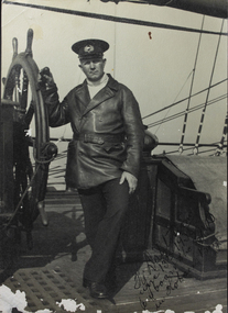 Mission to Seafarers Victoria
Photograph, circa 1935
In 1935, the CB Pedersen arrived on the 13th of April after 198 days at sea. The ship left on the 18th June (date written on the photograph) after two months in Melbourne. Captain Dalhstrom had been its skipper for 13 years. In the Sydney Morning Herald, Tuesday 27 April 1937, page 12: "The C. B. Pedersen was built in 1891. It has visited Australia several times, the most recent occasion having been in 1935, when It was anchored in Port Phillip Bay, Victoria, for several weeks, awaiting a suitable cargo. At length the master, (Captain Hjalmar Dahlström) announced that, as no cargo could be obtained he would be prepared to carry passengers in a voyage to Gothenburg, via Torres Strait. Eight persons, including three women and a small boy were accepted as passengers, and signed on as members of the crew at salaries of 1/ a month". Artist Violet Teague was one of the passengers. She painted during the voyage and exhibited her work in 1938. Built in 1891 the C.B Pedersen, a four-masted steel barque (2142 tons) was used as a training Barque. The ship foundered in April 1937, the crew was saved.The C.B. Pedersen was one of the last windjammers sailing in the 1930s with the Herzogin Cecilie and the Grace Harwar. Black and white photographLower right corner front in black ink: H. Dahlström / June 13th 1935 / On board the CBP / in Hobson's Bayc.b. pedersen, captain hjalmar dahlström, violet teague, windjammer, sweden -
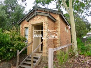 Eltham District Historical Society Inc
Photograph, Jim Connor, Former C.B.A. Bank, 14 Jan 2017
The Former Commonwealth Bank of Australia branch forms part of the Eltham Gateway and the Little Eltham precinct and is located near 804 Main Road, Eltham. It is a significant building and registered on the Victorian Heritage Register. The bank was built in 1878. It is a one-room, bichromatic brick building. Imagine your bank only being open for one morning a week! These were the hours of the Commercial Bank’s Eltham branch early in the 20th century and customers were quite content. The bank stored gold from the Eltham/Research mining areas. It is famous for its bullet holes. These were the result of a hold up in 1949, in which a nervous youth opened an account in the name of John Henderson, then walked to the door and spun around pulling out a pistol he fired into the cedar bench but fled empty handed and was apprehended later, receiving a two year sentence. The Bank was purchased by the Methodist Church in 1954. (The Eltham church is right adjacent). Recent uses have included a meeting room, Sunday School and Opportunity Shop. It is currently used as a storage for the Combined churches opportunity shop which is located in the United church extension beside this location. Tomorrow's history documented todayeltham, jim connor collection, main road, eltham gateway, cba bank, opportunity shop -
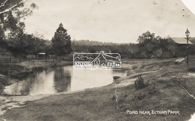 Eltham District Historical Society Inc
Photograph - Photo Postcard, Pond near Eltham Park, c.1910
This card depicts the pond near Eltham Park (later Eltham Lower Park) circa 1910. The view is taken from Maria Street (Main Road) opposite Dalton Street looking northwest across the Dalton Street road extension reserve (now Wingrove Park Trail) and Jarrold farm. A haystack is visible. Also visible is a gas streetlight and White Cloud cottage which belonged to the Jarrold family From the same collection as accession no. 00778, (Yarra at Eltham) - sent from Eltham and addressed to "Mr J. L. Brown, "Elthamville", Tinning Street, Brunswick" "with love from Nellie" who was most probably a member of the extended Brown family, and no. 00780 (Eltham, J.H. Clark Photo - dated 20 May 1911). Sending postcards to family and friends including short messages was a common form of communication in the early 20th century. Part of a slide show presentation "Bridges & Waterways of the Shire" by Russell Yeoman to the 13 September 1989 Society meeting. The presentation included slides of historic photos from the Shire of Eltham Pioneers collections as well as several recent views.Sending postcards to family and friends including short messages was a common form of communication in the early 20th century.Sepia postcard in very poor condition which has been removed from an album. Glue residue and album page adhering preventing information being readFront: Pond near Eltham Parkpostcard, eltham, pond, dalton street, duck pond, eltham park, elthamville, gas lamp, haystack, jarrold cottage, jarrold property, main road, maria street, white cloud cottage, wingrove park trail -
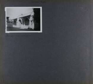 Glen Eira Historical Society
Album - Album page, Cromarty, Sandham Street, Circa 1972
This photograph is part of the Caulfield Historical Album 1972. This album was created as part of a project from approximately 1966-1972 by the Caulfield Historical Society to assist in identifying buildings worthy of preservation. This album is related to a Survey the Caulfield Historical Society developed in collaboration with the National Trust of Australia Victoria and Caulfield City Council to identify historic buildings within the City of Caulfield that warranted the protection of a National Trust Classification. Photographers Jenny O’Donnell and Trevor Hart, members of Caulfield Historical Society. Some photographs are older and from unknown sources. All photographs are black and white except where stated. From Victorian Heritage Database citation for HO61 Presentation Convent, 28 Sandham Street Elsternwick https://vhd.heritagecouncil.vic.gov.au/places/35476 (as at 1/11/2020) The "Presentation Convent" is locally significant as a substantial late Victorian villa residence in Elsternwick and for its more recent role in the educational and spiritual lives of the community. https://vhd.heritagecouncil.vic.gov.au/places/65716 (as at 21/08/2021) National Trust Property No B2713 Typical of period but yet interesting for association with Horatio Beauchamp. Classified 26/11/1970 Victorian Heritage Database citation for HO61 Presentation Convent, 28 Sandham Street Elsternwick https://vhd.heritagecouncil.vic.gov.au/places/35476 A substantial two storeyed stuccoed asymmetrical Italianate villa residence, representative of its period, with two storeyed cast iron verandah and projecting facetted bay with trabeated treatment to the ground floor and round arched upper level windows with distinctive moulds.Page 185 of Photograph Album with one photograph of Cromarty.Handwritten: SANDHAM STREET [top] / CROMARTY - OLD CLASSROOMS [under photo] / 185 [bottom left]trevor hart, chimneys, porch, cast iron lacework, school, education, presentation sisters, catholic girls college, balcony, verandah, presentation convent, sandham street, victorian villa residence, villa residence, cast iron frieze, cast iron columns, protruding bay, bay window, 1880's, double storey, cromarty, chiselhurst, chisel hurst, horatio beauchamp, elsternwick, classrooms, class rooms, late victorian style, arched windows -
 Surrey Hills Historical Society Collection
Work on paper - Photograph, Nethercourt Private Hospital, Surrey Hills, c 1924, 1924
Notes from a previous collection coordinator indicate that Miss Lucy Musselwhite (Lillywhite) opened the hospital in 1914 and Matron Eliza Tank took it over in 1921 and named it Nethercourt Private Hospital. However recent research suggests that Miss Musselwhite (name confirmed) moved from Tooronga to Wilson Street some time between 1903 and 1909. She and her mother Elizabeth are listed in the 1909 electoral rolls in Wilson Street and Lucy's occupation is given as nurse. (It is of course possible that the property was a residence only at this time and later opened as a private hospital.) The name Nethercourt was used prior to Matron Eliza Tank taking over. Her daughter Irene was also a nurse at Nethercourt. Lucy Musselwhite was born in 1873 in Hampshire. She married Henry James Dore in later life and lived in Brenbeal Street, Balwyn. She died in 1955. In 1930 / 1935 Matron Tank transferred the hospital to 219-223 Union Road. Later it was known as Norwich Hall / St Jude's. Mosgiel Hospital in Mont Albert Road also opened in 1924. After this time home births became less common. Nethercourt Hospital closed in the 1960s.Small hospitals such as this one were primarily used for midwifery, preceding the development of larger centralised general hospitals. Black and white photo of Nethercourt Private Hospital at 11 Wilson Street in c 1924 taken from the street in winter. The building is Victorian in style; block-fronted with lacework detail to the verandah and has 2 chimneys. It is set behind a wooden picket fence behind which is a well-manicured hedge which appears to have been grown across the front entrance gate.nethercourt private hospital, midwifery, hospitals, matron eliza tank, miss lucy musselwhite, miss irene tank, mrs irene anderson -
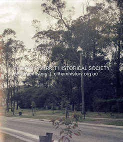
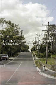
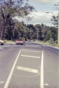
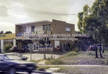
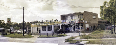 Eltham District Historical Society Inc
Photograph, Beard Street and Main Road Eltham, 20 Jan 1986, 20/01/1986
During the recent refurbishment of our Local History Centre we came across a roll of 35mm colour negatives which at some stage had been exposed to water or similar resulting in the individual strips sticking to each other and the old paper film processing envelope. The situation looked hopeless but one of our members had an idea on how to salvage them; after all, we had nothing to lose. In the end we were able to separate the film strips and remove most of the paper residue except some of the adhesive. The film was scanned and even though suffering from various light issues; fading, possible exposure problems and a yellow shadow cast by the adhesive residue, the detail and historical information they contain has been rescued. These images are all centred around the intersection of Beard Street and Main Road Eltham. The Sun headline is "Poison Dumped in Murray" which has been dated to 20 Jan 1986 1986 'Poison in Murray cuts town water', The Canberra Times (ACT : 1926 - 1995), 20 January, p. 1. , viewed 30 Aug 2017, http://nla.gov.au/nla.news-article122421767A favourite milk bar of the time for local youth as evidenced from comments on the ThrowbackThursday Facebook Page post. Frame 01791-1 shows the auction sign for the land on the southeast corner of Main Road and Beard Street which was developed into a small group of shopsRoll of 35mm colour negative film, 4 stripsKodak CL 200 5093eltham, main road, beard street, eltham east service centre, bp service station -
 Eltham District Historical Society Inc
Photograph, Beard Street and Main Road Eltham, 20 Jan 1986, 20/01/1986
During the recent refurbishment of our Local History Centre we came across a roll of 35mm colour negatives which at some stage had been exposed to water or similar resulting in the individual strips sticking to each other and the old paper film processing envelope. The situation looked hopeless but one of our members had an idea on how to salvage them; after all, we had nothing to lose. In the end we were able to separate the film strips and remove most of the paper residue except some of the adhesive. The film was scanned and even though suffering from various light issues; fading, possible exposure problems and a yellow shadow cast by the adhesive residue, the detail and historical information they contain has been rescued. These images are all centred around the intersection of Beard Street and Main Road Eltham. The Sun headline is "Poison Dumped in Murray" which has been dated to 20 Jan 1986 1986 'Poison in Murray cuts town water', The Canberra Times (ACT : 1926 - 1995), 20 January, p. 1. , viewed 30 Aug 2017, http://nla.gov.au/nla.news-article122421767A favourite milk bar of the time for local youth as evidenced from comments on the ThrowbackThursday Facebook Page post. Frame 01791-1 shows the auction sign for the land on the southeast corner of Main Road and Beard Street which was developed into a small group of shopsRoll of 35mm colour negative film, 4 stripsKodak CL 200 5093eltham, main road, beard street, eltham east service centre, bp service station