Showing 23110 items matching "sardine-creek"
-
 Ballarat Heritage Services
Photograph - Video, Clare Gervasoni, Confluence of Canadian Creek and Yarrowee River near Anderson Street, Ballarat, 06/09/2022
The waterways of central Ballarat were channeled to prevent flooding and contain sludge during the mining era.Video of the confluence of Canadian Creek and Yarrowee River near Anderson Street, Ballarat flowing down a channel.canadian creel, yarrowee river, ballarat, anderson street, channel, bluestone -
 Whitehorse Historical Society Inc.
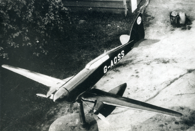
Photograph, Model on house at Creek Road Mitcham, 1939/40
Black and white 1939/40 photograph of model aeroplane on house (now demolished) at Creek Road, Mitchamcreek road, mitcham, thompson, george -
 Ballarat Heritage Services
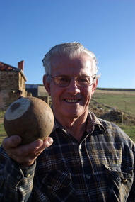
Photograph - Colour, Clare Gervasoni, Maurie Gervasoni holds a wooden bocce ball at Yandoit Creek, 2016, 2016
Colour photographs of Maurie Gervasoni holding a wooden bocce ball used by his ancestors at Yandoit Creek.maurie gervasoni, bocce, yandoit creek -
 Southern Sherbrooke Historical Society Inc.
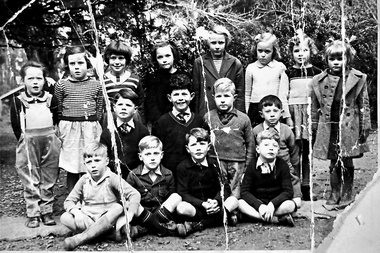
Photograph, Menzies Creek State School photo
A photograph of sixteen students from Menzies Creek State School standing and sitting for a group photo. 1950s. -
 Southern Sherbrooke Historical Society Inc.
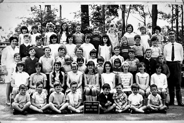
Photograph, Menzies Creek State School, 13th November 1969
A photograph shows students and two teachers from Menzies Creek State School, 13th November 1969. -
 Southern Sherbrooke Historical Society Inc.
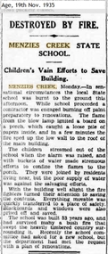
Article - Menzies Creek State School fire article, Destroyed By Fire - Menzies Creek State School
An article from The Age dated 19th Nov 1935, reporting a fire at the Menzies Creek State School. -
 Tarnagulla History Archive
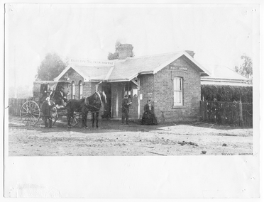
Photograph, People outside Sandy Creek (later Tarnagulla) Post Office, People outside Sandy Creek (later Tarnagulla) Post Office, c.1856-1880
Murray Comrie Collection. Date of image: This office opened in August 1856. Large hoop skirt on subject suggests probably not later than 1880. This photograph is a good copy created from an older original.Monochrome photograph of people and a horse drawn buggy outside the Sandy Creek (later Tarnagulla) Post Office.tarnagulla, post office, construction, businesses, commercial road -
 Ringwood and District Historical Society
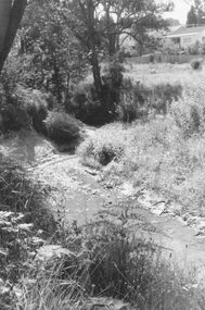
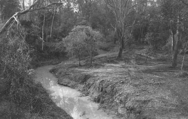
Photograph, Mullum Creek, 50 yards west of bridge in Ringwood Street Ringwood. May 1971
Writing on back of small photograph reads, "May 1971. Mullum Creek, 50 yards west of bridge in Ringwood St." Enlargement reads, "Mullum Creek looking west from bridge in Ringwood St. July 1972". -
 Ringwood and District Historical Society
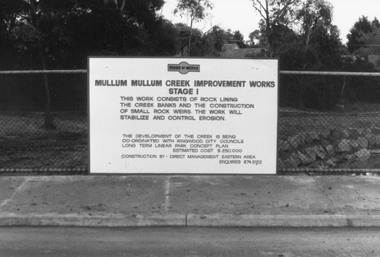
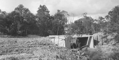
Photograph, Mullum Creek Improvement Works (Undated - possibly 1980's)
Collection of 4 photos of Mullum Mullum Creek Improvement Works. Sign on wire fence: "Mullum Mullum Creek Improvement Works Stage 1", "This work consists of rock lining the creek banks and the construction of small rock weirs. The work will stabilize and control erosion". Estimated Cost $250,000. Undated, but phone number does not have "9" prefix. Possibly early-mid 1980's?(Photo V0174 is a duplicate of V0173 and was not scanned. There is no photo V0172)Nothing written on photograph. -
 Ringwood and District Historical Society
Photograph, Mullum Mullum Creek, east of Warrandyte Road 1986
Written on back of photograph, "3/8/86. Mullum Mullum Creek, east of Warrandyte Road." -
 Ringwood and District Historical Society
Photograph, Looking south across Mullum Creek from Wildwood Grove, 1972
Written on backing sheet, "Looking south across Mullum Creek from Wildwood Grove, 1972". -
 Ringwood and District Historical Society
Photograph, Mullum Creek from bridge in Warrandyte Rd. Looking east, 1972
Written on backing sheet, "Mullum Creek from bridge in Warrandyte Rd. Looking east, 1972" -
 Ringwood and District Historical Society
Photograph, Mullum Creek from bridge in Warrandyte Rd. Looking east, 1973
Written on backing sheet, "Mullum Creek from bridge in Warrandyte Rd. Looking east, 1973". -
 Ringwood and District Historical Society
Photograph, Mullum Creek looking east from bridge in Warrandyte Road Ringwood. St. Paul's extreme left, 1972
Typed below photograph, "Mullum Creek looking east. St. Paul's extreme left, 1972". -
 Ringwood and District Historical Society
Photograph, Bridge over Mullum Creek under construction, Oliver Street. 1963
2 photographsWritten on back of photograph, "Bridge over Mullum Creek, Oliver Street. 17/11/1963" -
 Ringwood and District Historical Society
Photograph, Warrandyte Road Bridge over Mullum Mullum Creek, Ringwood 1986
Written on back of photograph, "3.8.86. Ringwood. Warrandyte Road Bridge over Mullum Mullum Creek". -
 Upper Yarra Museum
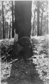
Negative Photographic Reproduction, H. Lepoidevin falling a tree Early 1920s Hoddles Creek
H. Lepoidevin falling a tree Early 1920s Hoddles Creek Negative Black white Scanned at 600 dpi.h lepoidevin falling tree hoddles creek early 1920s -
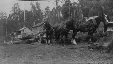 Upper Yarra Museum
Negative Photographic Reproduction, Working with horses at Mc Crae Creek mill 1945 Beenak
Working with horses at Mc Crae Creek mill 1945 Beenak Black and White negative scanned at 600 dpiworking horses mc crae creek mill beenak 1945 -
Ringwood and District Historical Society
Envelope, Packet: Dandenong Creek Committee - notes re DVA, Consultation Committee. Correspondence. 1990s
16 pages typed and some handwritten notes Dandenong Valley Authority, Dandenong Creek Community Consultative Committee -
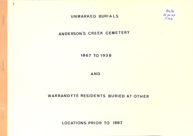 Ringwood and District Historical Society
Book, Unmarked Burials Anderson's Creek Cemetery and Warrandyte Residents Buried At Other Places
Unmarked Burials from 1867 to 1938 at Anderson's Creek Cemetery and Warrandyte Residents Buried at other places to 1867 -
Whitehorse Historical Society Inc.
Map, Nunawading - Deep Creek, 1868
Map of Nunawading - Deep Creek area On verso: Copy of map with letter to Minister of Lands and Works. 1868 [ND 933]Map of Nunawading - Deep Creek area On verso: Copy of map with letter to Minister of Lands and Works. 1868 [ND933]Map of Nunawading - Deep Creek area On verso: Copy of map with letter to Minister of Lands and Works. 1868 [ND 933]maps, mitcham -
Whitehorse Historical Society Inc.
Document, Gardiner's Creek, 1/03/1989 12:00:00 AM
John Gardiner and Gardiner's Creek; talk by W. Dempsey.John Gardiner and Gardiner's Creek; talk by W. Dempsey, 23/3/1989 (Box Hill Historical Society)John Gardiner and Gardiner's Creek; talk by W. Dempsey. gardiner, john, gardiners creek -
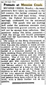 Southern Sherbrooke Historical Society Inc.
Article, Protests at Menzies Creek
Article titled “Protests at Menzies Creek” about pensioners protesting cuts in pensions. Age 6th September 1932. -
 Stawell Historical Society Inc
Photograph, Stawell West Ladies Book Launch at Pleasant Creek Court House 6 Photos -- Coloured
Stawell West Ladies Book Launch at Pleasant Creek Court House in c 2004 Series of photographs. Photo 1). Jim Melbourne, Cynthia Bodey & Keith Haymes. Photo 2). Author Jim Melbourne signing copies. Photo 3). Ron & Wendy Maddocks, Pat Boag, Marg Rasche. Betty Smith & Dawn Miller. Photo 4). Ron & Wendy, Pat, Marg, Betty & Alan Miller, Marie van Leeuwen (standing), Keith & Elwyn Haymes. Photo 5). Seven of the above mentioned people. Photo 6). Elwyn, Hazel Smith, Lorna Keller & Heathe Wood visitor & sister of Lorna. Photo 7). Ten of Previously noted people. Photo 8). Heather, Elaine McCracken, Mary Kent, Irene McDonald (standing) & Marg McIntosh. The appears to be 2 photos listed in the catalogue worksheet but not in the photo album. A series of 6 colour photographs of a book launch of Stawell West Ladies Axillary History 1957 to 2003. The book launch was held on 19th April 2004 at Pleasant Creek Court House. c 2004. In the Museum catalogue worksheet there is reference to 8 photos and only 6 are in the Album. stawell -
 Melbourne Tram Museum
Photograph - Digital Image, Kevin O'Reilly, "Merri Creek on CD, of looking from above Rushall station towards Clifton Hill Station, c1930's
Image from CD (Compact Diskette for use in computers) - see Reg Item 135. Image titled "Merri Creek on CD, of looking from above Rushall station towards Clifton Hill Station with the Merri Creek on the left side of the photo. Shows cable trams in Queens Parade, cable trams shunting, the Clifton Hill cable tram depot, and the railway bridge over Merri Creek. 1930's? Photo has lots of white spots on the image.trams, tramways, merri creek, clifton hill, rushall station, cable trams -
 Eltham District Historical Society Inc
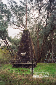
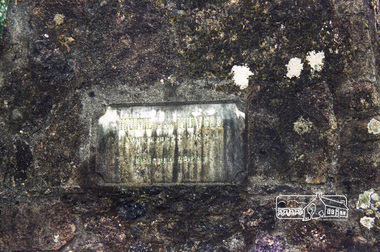
Photograph, Hume and Hovell Monument, Back Creek Road, old Back Creek school site, Back Creek, c.1998, 1998c
Stage 3 tour of Hume and Hovell monuments organised by Russell Yeoman. At the centenary of Hume and Hovell exploration in 1924 a committee was formed to co-ordinate and organise local celebrations along the route from Albury to Corio Bay. An itinerary was created for the unveiling ceremonies giving the hour and date for each place concerned from 15 to 21 November 1924. Thirty-three monuments or cairns were erected at Violet Town, Euroa, Avenel, Seymour, Broadford, Kilmore, Mount Bland, Bulla, Moyhu, Hansonville, Benalla, Samaria, Swanpool, Yarck, Yea, The Horn (Buffalo), Myrtleford, Whorouly, Everton, Murmungee, Stanley, Back Creek, Allan's Flat, Staghorn Flat, Ebden, Bethanga, Hume Reservoir, Strath Creek, Deer Park, Werribee, Lara, Bulla, Everton.Roll of 35mm colour negative film, 7 stripsKodak Gold 200-6activities, back creek, hume and hovell, monument -
 Eltham District Historical Society Inc
Photograph, Hume and Hovell Monument, Back Creek Road, old Back Creek school site, Back Creek, c.1998, 1998c
Stage 3 tour of Hume and Hovell monuments organised by Russell Yeoman. At the centenary of Hume and Hovell exploration in 1924 a committee was formed to co-ordinate and organise local celebrations along the route from Albury to Corio Bay. An itinerary was created for the unveiling ceremonies giving the hour and date for each place concerned from 15 to 21 November 1924. Thirty-three monuments or cairns were erected at Violet Town, Euroa, Avenel, Seymour, Broadford, Kilmore, Mount Bland, Bulla, Moyhu, Hansonville, Benalla, Samaria, Swanpool, Yarck, Yea, The Horn (Buffalo), Myrtleford, Whorouly, Everton, Murmungee, Stanley, Back Creek, Allan's Flat, Staghorn Flat, Ebden, Bethanga, Hume Reservoir, Strath Creek, Deer Park, Werribee, Lara, Bulla, Everton.Roll of 35mm colour negative film, 7 stripsKodak Gold 200-6activities, back creek, hume and hovell, monument -
 Puffing Billy Railway
Clarkat Tug Locomotive, 13 April 1943
Clarkat A Clarkat Aircraft Tug that has been converted to run on Rails, This Clarkat 'B' was one of 11 machines shipped on 13 April 1943 to the Lathrop Holding & Re-consignment Depot in Lathrop, California. and was used at Jack's Magazine, Maibyrnong, Victoria and later on at Coal Creek Historical Village, Gippsland, Victoria. Clarkat Tug Model C S/N Cx30F Made by Clark Tructractor Div of Clark Equipment Co Battle Creek Michigan U.S.A Serial No. CK 43 470 Code: Heavy Des.Pat. 116092 Historic - Industrial Narrow gauge railway equipment - Jack's Magazine, Maribyrnong, Victoria, Australia Clarkat Aircraft Tug that has been converted to run on Rails, made of steel Coal Creek Tug Clarkat Serial No. CK 43 470 Code: Heavy Des.Pat. 116092 clarkat, clarkat aircraft tug, puffing billy, jack's magazine -
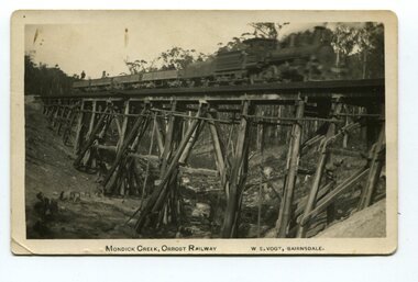 Orbost & District Historical Society
black and white photograph, Vogt. W.S, first half 20th century
This 97km Bairnsdale to Orbost extension through rugged terrain was reputed to have been the most difficult rail project undertaken in Victoria. This wooden bridge was one of the unique railway bridges of the East Gippsland Railway line. Mundic Creek Bridge is of unique design because the line crosses at a very sharp angle. This bridge like many others on the line have "disappeared". This one, probably because of a bushfire.The Bairnsdale to Orbost rail line contains the most varied range Of timber & timber composite bridges on any Victorian line. This photograph is a record of that. A black / white photograph of a train on a wooden railway bridge at Mundic Creek.on front - Mundic Creek, Orbost Railway W.S.Vogt, Bairnsdalemundic-creek-bridge east-gippsland-railway -
 Lakes Entrance Historical Society
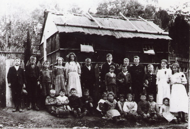
Photograph - The Farm School, 1910 c
Names listed in file, from publication Clifton Creek'1988.Black and white photograph of twenty five students at The Farm school of bark, with bark roof stabilised with timber. Windows are glazed. Situated near Clifton Creek, Victoriaschools, students