Showing 1579 items matching "shopping centre"
-
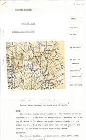
 Ringwood and District Historical Society
Newspaper, Scrapbook Clipping, Library Collection, Ringwood, Victoria
... shopping centre.... of Eastland shopping centre. Newspaper Clipping from "The Post", 3 May ...Newspaper Clipping from "The Post", 3 May 1993, Page 4, "Manager sought for Civic Centre make-overThe possibilty Ringwood Civic Centre might be relocated in future was considered before council decided to advertise for a manager for the proposed $1.03 million refurbishment project later in 1993, Cr Max Williams told residents at the last council meeting. Several residents believe council might decide to incorporate a new Civic Centre in plans for a retail and commercial development it is currently considering building in front of Eastland shopping centre. -
 Greensborough Historical Society
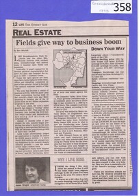
Newspaper clipping, Fields give way to business boom, 1993_
... of two suburban Melbourne shopping centres, at Dandenong... of Greensborough shopping area. In Canberra Times Wednesday 17 November ...Tells some of the story of the settlement of Greensborough and Lend Leases' gradual take over of Greensborough shopping area. In Canberra Times Wednesday 17 November 1993, page 27: Melbourne: Lend Lease Corp Ltd is to undertake a $600 million redevelopment of two suburban Melbourne shopping centres, at Dandenong and Greensborough; to be built in conjunction with Australia's largest retailer; Coles Myer Ltd. The project will create about 2000 jobs; 1000 during construction and 1000 in long-term retail.Has some history of Greensborough and records the average land prices in 1993. A black and white Sunday Age newspaper story. Includes map and photograph of resident.greensborough, lend lease, 1993, land prices -
 Melbourne Tram Museum
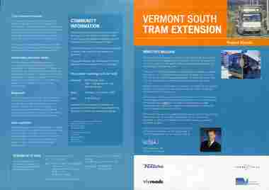
Pamphlet, Department of Infrastructure (DOI), "Vermont South Tram Extension" - set of 2, Oct. 2003
... shopping centre. Includes a message from the Minister... shopping centre. Includes a message from the Minister for Transport ...Pamphlet titled "Vermont South Tram Extension", about the proposal to extend route 75 from Blackburn Road to Vermont South shopping centre. Includes a message from the Minister for Transport Peter Batchelor, with notes on the project, background work, project timing, traffic management, and a forthcoming project public meeting to be held on 15/10/2003. Published by DOI. Second pamphlet gives details of project timing. Both have logos of Ventura, Yarra Trams, vicroads and DOI.Yields information about the DOI project to extend route 75 to Vermont South.Pamphlet - four page A4 full colour and four fold DL.trams, tramways, planning, doi, route 75, vermont south, new tramways, projects -
 Whitehorse Historical Society Inc.
Photograph, View from Mitcham Pedestrian Bridge, 1/07/2000 12:00:00 AM
... Road, Mitcham, looking north-east towards the Mitcham Shopping..., Mitcham, looking north-east towards the Mitcham Shopping Centre ...Coloured photo from the pedestrian overpass on Whitehorse Road, Mitcham, looking north-east towards the Mitcham Shopping Centre.- North - side. House with Spanish taste belonged to Mr. Peake of Peake and Cox, the timber yard directly across Whitehorse Road from this house which became the new site of St.John's Roman Catholic Primary School. This house was on the corner of Whitehorse Road and Albert Street. Upon the sale of the timber yard and mill the catholic church the house was also sold to the church and was occupied as a residence for the school's teaching Sister's. (House since demolished)whitehorse road, mitcham, pedestrian overpass -
 Eltham District Historical Society Inc
Photograph - Photograph postcard, A peep at the picnickers, Eltham, c.1904
... . Haley’s Paddock (now occupied by Eltham shopping centre.... Haley’s Paddock (now occupied by Eltham shopping centre ...Postcards scanned from the collection of Michael Aitken on loan to EDHS, 13 Feb 2018 Reproduced ‘Pioneers & Painters’ pp 52-53. Picnickers enjoying a Sunday outing in the fields opposite Eltham Railway Station. Looking north towards Research along Main Road near the intersection with Dudley Street. Luther Hayley’s Bakery and General Store on left promoting refreshments and summer drinks. With the opening of the railway to Eltham in 1902, Melbourne residents would regularly enjoy a Sunday excursion journey on the train to Eltham for a day’s outing to the countryside. Possibly the annual State schools picnic held by the Board of Advice at Haley's Paddock near Eltham railway station on 11 March, 1904. Haley’s Paddock (now occupied by Eltham shopping centre) was capable of accommodating 10,000 people, with ample shade and hilly surroundings, an ideal place for any gathering. The main foreground is the site of the present day Eltham Village and Coles Shopping Centre. 1904 'STATE SCHOOLS' PICNIC.', Record (Emerald Hill, Vic. : 1881 - 1954), 19 March, p. 3. http://nla.gov.au/nla.news-article165173087Digital file only Postcards scanned from the collection of Michael Aitken on loan to EDHS, 13 Feb 2018michael aitken collection, postcards, eltham, main road, bakery, eltham village reserve, general store, haley's paddock, luther haley, luther haley general store, picnic, pioneers and painters, railway store, shire of eltham pioneers photograph collection, summer drinks -
 Glen Eira Historical Society
Article - BALACLAVA ROAD, 230-232, CAULFIELD NORTH
... it is not specified as to whether it is a shopping centre, warehouse... is commercial, though it is not specified as to whether it is a shopping ...This file contains one item: 1/A cutting of an article from the commercial real estate subsection of The Age, dated 13/11/2010, describing a property located at 230-232 Balaclava Road, Balaclava Junction, Caulfield North. The property is commercial, though it is not specified as to whether it is a shopping centre, warehouse, or whatever else. Listed are the building’s size, condition, current rental revenue, parking facilities, nearby amenities, auction date and expected selling price range, as provided by Gross Waddell Real Estate Agency.commercial establishments, balaclava road, hawthorn north, caulfield north, rents and renting, car parks, gross waddell, real estate agencies, gross michael -
 Sunbury Family History and Heritage Society Inc.
Photograph, Clarke Oval
... Sunbury Shopping Centre was where football was played until Clark... Shopping Centre was where football was played until Clark Oval ...The Sunbury Football Club, known as 'The Swifts' was formed in 1897 and the early matches were probably played on Munro's which was a stretch of land bounded by Evans, Barkly, O'Shanassy and Shields Streets. Later land adjacent to the railway line, now Sunbury Shopping Centre was where football was played until Clark Oval was opened in 1953. Since then it has been the town's main sporting venue and the site for the annual show and other events. In this photograph the football match is being played on the Clark Oval with the clubrooms visible in the background. The Sunbury Football Club is one of a number of sports clubs established vin Sunbury.A non-digital black and white photograph of a football match being played on an oval. The clubrooms are visible in the distance.sunbury football club, clark oval, "the swifts' -
City of Kingston
Photograph - Black and white, 27 February 1964
... of the future Southland shopping centre has not yet been demolished... of the future Southland shopping centre has not yet been demolished ...Cheltenham is a suburb in the City of Kingston that was originally established as a rural market gardening community. The area is bordered by Highett. The previous market gardens, farms and paddocks have gradually been sub-divided into housing and industrial estates. The Methodist Children's Home Methodist Homes for Children and St John of God Training Centre on the site of the future Southland shopping centre has not yet been demolished. The recently built Cheltenham High School is visible and the increased urbansation of the area is evident. Some farmland remains including the Le Page homestead.The developing urban area of Cheltenham within the City of Kingston. This image illustrates the mid-century urban sprawl of of Cheltenham and the subdivision of market gardens within the municipality and the changing demographic of the district as new houses are constructed and infrastructure established.Aerial photograph of the suburbs of Cheltenham and Highett within the City of Kingston. Highett Gas Works (top left); Bernard Street, Cheltenham (top right); Weatherall Road (bottom left): Elliott and Cobham Streets Cheltenham (bottom right).White handwritten: X Vic.1831 White type: MELBOURNE 1963 PROJECT RUN23 [underlined] 27-2-64 LENS 205 152-70 M/M 5.150 [arrow] White handwritten: X 166 cheltenham, highett, urbanisation -
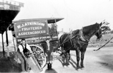 Surrey Hills Historical Society Collection
Photograph, Delivery cart outside Mr & Mrs W. J. Atkinsons's greengrocery business near the corner of Elgar and Whitehorse Roads, c1930
... as it approaches the shopping centre and over the back of the horse can... be seen Whitehorse Road as it approaches the shopping centre ...Delivery cart of Mr & Mrs W J Atkinson’s greengrocery business and general store near the corner of Whitehorse and Elgar Roads, c 1930. Emma Uebergang and William James Atkinson married in 1930. They ran a mixed business in Whitehorse Road from 1926-1952. Stock included fruit and vegetables, sweets and some groceries. With Mr Atkinson is Albert Cunnington who in about 1930 helped with deliveries. To the left can be seen Whitehorse Road as it approaches the shopping centre and over the back of the horse can be seen the White Horse Hotel. This was demolished in 1938.A black and white photograph of a horse and delivery cart identified as W. J. Atkinson Fruiterer and Greengrocer, 33? Whitehorse Road Box Hill.land transport, carts and wagons, horse drawn vehicles, fruiterer and greengrocer, whitehorse road, elgar road, mont albert, box hill, mr william james atkinson, mrs emma gertrude atkinson, miss emma gerte uebergang, mr albert cunningham -
 Melbourne Legacy
Photograph, Legacy Appeal 1992, 1992
... Victoria Hospital has been demolished and the new QV shopping... Victoria Hospital has been demolished and the new QV shopping ...A photo of President G. M. Swan with a group of school boys with Appeal tins. Also a police band on Swanston Street and a trading table set up by the Legacy Widows outside Legacy house. The widows clubs ran a craft stall outside Legacy house for many years to help with fundraising during Legacy Week. Also the author Patsy Adam-Smith is in one photo. She went on to be a celebrity of the year for Legacy in 1994. Of note is that the Queen Victoria Hospital has been demolished and the new QV shopping centre has not yet been built.A record of Legacy Week in 1992.Colour photo x 3 of Legacy Appeal in 1992.Printed on the back "707 0131 N N N 1 2" and 708. On Kodak paper. legacy week, badge week, legacy appeal -
 Eltham District Historical Society Inc
Photograph, Looking south along Main Road, Eltham near John Street, c.1970, 1970c
... Opportunity Shop) in centre left. The building on immediate left has... Opportunity Shop) in centre left. The building on immediate left has ...Eltham Uniting Church and former CBA bank (later Opportunity Shop) in centre left. The building on immediate left has since been demolished and is now the site of Goodstart Early Learning Eltham kinder120 format 6x9 clr positivecba bank, john street, main road, pitt street, uniting church -
Glen Eira Historical Society
Plan - Centre Road, Bentleigh
... for the auction of six shops on Centre Road, Bentleigh near Jasper Road... advertisement for the auction of six shops on Centre Road, Bentleigh ...Two copies of a one page printed advertisement for the auction of six shops on Centre Road, Bentleigh near Jasper Road to be held on 07/03/1950. The advertisement includes a plan (51mm x 127mm) of the sitesmeldrum w, centre road, bentleigh, plans, advertisements -
City of Kingston
Photograph - Colour, 29 January 1993
... shopping Centre; Top right - Scotch Parade Chelsea Bottom left...: Top left - Maury Road at the south end of the Chelsea shopping ...Bonbeach is a small beachside suburb located between Chelsea and Carrum. The station was opened in 1926 and was the last to be established in the group from Aspendale to Carrum. Urban growth began after World War II. State primary and high schools were opened in 1958 on land in Breeze Street that was once occupied by The Australian Glass Manufacturers. Immediately east of the school sites is the Patterson River Golf Club. The Bonbeach sports reserve has five ovals and is home to the Bonbeach football and baseball clubs. The suburb borders the Edithvale-Seaford Wetlands which is the remnant site of the Carrum Carrum swamp, once the home of the Bunurong people.Bonbeach was originally a seaside destination for holidaymakers and the housing comprised of holiday homes and gradually more permanent residents. It was not until 1926 that Bonbeach had its own railway station. From 1906 until the late 1940s sand was quarried on the east side of the railway line and used in the manufacture of glass. The Australian Glass Manufacturers sold this land in residential blocks and Bonbeach's permanent population spread from the coastal strip across to the other side of the railway line. Laminated colour aerial photograph of the suburb of Bonbeach and also the southern section of neighbouring Chelsea within the City of Kingston. The extent of this 1993 aerial image includes: Top left - Maury Road at the south end of the Chelsea shopping Centre; Top right - Scotch Parade Chelsea Bottom left - Monica Avenue in Bonbeach; Bottom right - Patterson River Golf Club. Landmarks include St Joseph's Church and Primary School, Chelsea Primary School, Bonbeach Station, Bonbeach Fotball Club sports playing fields and Bonbeach Life Saving Club. The Edithvale Wetlands is featured prominently to the right-hand side of the image. Black typed writing on white adhesive label: No. 6662 Black typed writing on white adhesive label: 26E/6662, 29/1/93, 4.25 pm Black typed writing on white adhesive label: 29-1-93 Black typed writing on white adhesive label: P000109 Circular yellow adhesive sticker bonbeach, chelsea -
 Bendigo Historical Society Inc.
Document - ALBERT RICHARDSON COLLECTION: FORTUNA HUSTLERS MINE
... (Discovery Centre location) in an area occupied by Buckell... of Marketplace shopping centre). It commenced operation in August 1888 ...Two-page document with location map. The Fortuna Hustlers Gold mine was located close to the railway goods shed (Discovery Centre location) in an area occupied by Buckell and Jeffrey's office and yards. (now carpark of Marketplace shopping centre). It commenced operation in August 1888 and closed in December 1913.The depth of the shaft was 2,240ft. Features of the plant described are: the winding engine, the air compressor, boilers, baling tanks, poppet legs, engine house. The winding engine later worked at the Tambour Major at Specimen Hill; Birds Reef at Kangaroo Flat, Hercules No. 1 on top of Danger Hill and the North Virginia mine at Eaglehawk.bendigo, mining, fortuna hustlers mine -
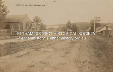 Eltham District Historical Society Inc
Postcard - Photograph postcard, Main Road, Greensborough, c.1910
... Plaza shopping centre at 25 Main Street, Greensborough... to Greensborough Plaza shopping centre at 25 Main Street, Greensborough ...View looking northeast along Main Street. The Greensborough Methodist Church stood at the present-day entrance to Greensborough Plaza shopping centre at 25 Main Street, Greensborough. It was opened in 1873. The Main Street Church served the congregation well, but by the 1960s it was decided to sell the old building and invest in a new home. The land at 37 Grimshaw Street for the current Uniting church was purchased in 1962 from the estate of Mrs White. Construction commenced on 31 July 1965 and the new church was opened on February 5, 1966. (https://www.churchhistories.net.au/church-catalog/greensborough-vic-uniting)Digital file only Postcards scanned from the collection of Michael Aitken on loan to EDHS, 2 Sep. 2022michael aitken collection, postcards, greensborough, main street, methodist church -
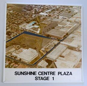 Sunshine and District Historical Society Incorporated
Photograph (1982) - Part Sunshine Business Area, Sunshine Centre Plaza Stage 1, 1982
... , and which have since been replaced by two shopping centres... since been replaced by two shopping centres and the library ...The Sunshine business area has undergone major change from industrial manufacturing to retail. This aerial photograph shows the industrial areas that existed on both sides of Hampshire Road in 1982, and which have since been replaced by two shopping centres and the library building. The photograph also shows the old swimming pool, and retail outlets that no longer exist such as Waltons, Clark Rubber, Fosseys and the original Safeway store. It also shows a vacant land where the current Centrelink office now exists. The photograph was originally used as a promotion for the Sunshine Centre Plaza retail complex.This photograph is a historical record of what part of Sunshine looked like 3 decades ago.Large cardboard mounted sepia photograph with thin white plastic edging. Grey painted outline shows the site in 1982 on which the SUNSHINE CENTRE PLAZA was to be built, as well the buildings that then existed in part of the business area of Sunshine.Sunshine Centre Plaza Stage 1aerial view, 1982, sunshine centre plaza, sunshine business area, massey ferguson buildings, old sunshine pool. waltons -
 Greensborough Historical Society
Newsletter, Greenhills and North Greensborough Progress Association, Community News: official journal of the Greenhills and Nth. Greensborough Progress Association and the Apollo Parkways Progress Association.1st September, 1976. Edition No. 8/76, 01/09//1976
... new shopping centre, Odds & sods, Local man has international... new shopping centre, Odds & sods, Local man has international ...This edition includes a report on the The Apollo Parkways Progress Association, Mens issue, 4 wheel driving, All a smokescreen?, Value of freedom or freedom of values, One view of our new shopping centre, Odds & sods, Local man has international voice [John O'Connor], What is a councillor's role?, From the Council Chambers, Meet the natives, Cameo of Len Delacca, Scout news, School and Kinder news, Fathering, Nursing Mothers Association, Parent Australia, This, that and the other, Diamond Valley Repertory, Malcolm Blair reserve. A digital copy of this Newsletter is available from Greensborough Historical Society. Newsletter, 32 p., illus.greenhills and north greensborough progress association, greenhills, apollo parkways progress association -
 Eltham District Historical Society Inc
Postcard, Take a seat in history, Alistair Knox Park, Eltham; Celebrating Children's Week 2000, 2000
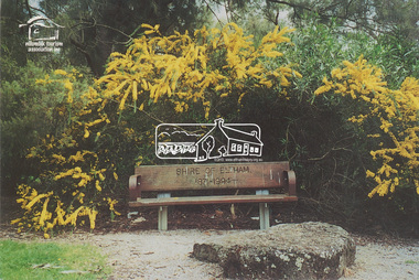
... in the Montmorency Shopping Centre referencing the west riding of the Eltham... Shopping Centre referencing the west riding of the Eltham Shire ...Postcard as part of a series produced by Shire of Nillumbik for a children's photo project "Nillumbik Naturally" developed by FOCUS FORCE cleebrating Children's Week 2000. Words and photo by Janelle Chambers (Age 13). The logo for the Nillumbik Tourism Assocation Inc is stamped on the front of the postcard. This seat was placed in Alistair Knox Park in commemoration of the end of the Shire of Eltham after Victorian Council amalgamations with the words "Shire of Eltham 1871-1994" included on the back wooden plate of the seat. A similiar seat was placed in the Montmorency Shopping Centre referencing the west riding of the Eltham Shire, which incuded Montmorency. Digital file only - Digitised by EDHS from a scrapbook on loan from Beryl Bradbury (nee Stokes), daughter of Frank Stokes. Also physical postcard (used) alistair knox park, beryl bradbury (nee stokes) collection, janelle chambers, nillumbik tourism association, wattle, seat, children's week, commemoration -
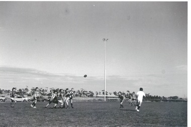
 Ringwood and District Historical Society
Photograph, Croydon West High School off Cutts Avenue and Maroondah Hwy, Ringwood - November, 1969
... , later succeeding her as Queen. The Burnt Bridge Shopping Centre.... The Burnt Bridge Shopping Centre can be seen in the far west on one ...Written on backing sheet, "West Croydon School (In Ringwood municipality)". November 1969. The area behind the pine trees was used as a training ground by the Wilhelmina Soccer Club, later called Ringwood City SC and Ringwood FC. It was later sub-divided and the two streets named Wilhelmina and Juliana Courts, in honor of Wilhelmina, Queen of the Netherlands, and her daughter, Juliana, later succeeding her as Queen. The Burnt Bridge Shopping Centre can be seen in the far west on one of the images. -
 Federation University Historical Collection
Photograph, Ballarat photographs by Geoff Biddington, 1967, 1967
... Gallery) .3) Tram in Sturt Street .4) Geelong ? shopping centre .5... ? shopping centre .5) Geelong Waterworks and Sewerage Trust .6) Carn ....6) Australian Catholic University Ballarat Campus (Aquinas) is set in the historic gardens of Carn Brea, formerly the property of Cornish miner Cyrus Retallack. The property includes a two-storey mansion, which he built as his family home in 1881. Carn Brea, a castle in Cornwall, was built in the 1500s. After the Queen's Church of England Girls' Grammar School acquired the property in 1919, the mansion was renamed Manifold House. Manifold House now accommodates administrative facilities of the campus and staff offices. (http://www.acu.edu.au/about_acu/campuses/ballarat/history_of_ballarat_campus, accesses 21 August 2014)Nine black and white images by Geoff Biddington. .1) Burke and Wills Monument, corner Sturt Street and Lydiard Street, with the MLS Building and Allan Brothers in the background. .2) Former Ballarat Post Office (later Federation University Post Office Gallery) .3) Tram in Sturt Street .4) Geelong ? shopping centre .5) Geelong Waterworks and Sewerage Trust .6) Carn Brae / Retallacks / Queen's / Australian Catholic University, 1200 Mair Street .7) Former Ballarat Post OFfice, Lydiard Street .8) Perseus Statue, Camp Street (removed for conservation in 2008) .9 McDonald Printer, 48 Lydiard Stgeoff biddington, ballarat, ballarat post office, geelong waterworks, perseus, mcdonald, acu, carn brae, australian catholic university ballarat, burk and wills monument, mlc building ballarat, allan brothers ballarat, lydiard street, sturt street -
Kew Historical Society Inc
Plan - Charteris Estate, Ivanhoe [East], 1927
... , and Ivanhoe shopping centre [named Motor Cross Junction].... in Ivanhoe, a croquet ground, and Ivanhoe shopping centre [named ...Subdivision plans and real estate flyers/brochures reveal a number of aspects of urban development and history. The Kew Historical Society's collection of these plans, as well as advertisements extracted from magazines, cover key aspects of community development and architectural history of Kew and Kew Eat as well as surrounding suburbs. While most of the plans in the collection were gifted to the Society by the former City of Kew, a number of other plans and advertisements have been donated by individuals, of which this is an example.Original 4-page bifold handout advertising 43 residential lots for sale in the Charteris Estate subdivision in Ivanhoe [now classified as Ivanhoe East]. This brochure was created to sell the third section of the estate which it labels as 'The Most Superb Section'. Streets within the subdivision include: Burke Road North, McArthur Road, Castella Street, and the Government Boulevard. In addition to the overall plan spread across pages 2 and 3, each page includes a number of interesting photographs including: a number of the new Burke Road Bridge, a sports ground, Hoyts Picture Theatre in Ivanhoe, a croquet ground, and Ivanhoe shopping centre [named Motor Cross Junction].charteris estate - east ivanhoe (vic), subdivision plans -- ivanhoe east (vic.), d.c. mcarthur, charterisville -
Glen Eira Historical Society
Document - GARDENVALE
... Shopping centre, including efforts by local people and the council... the railway embankment to Gardenvale Shopping centre, including ...This file contains two items about Gardenvale, which was previously all part of Caulfield: 1/Photocopied eight page document by M. Stewart, 1961, entitled ‘The Gardenvale Story’. It describes Gardenvale Railway and surrounding roads and land. Lempriere’s Paddock, rail tracks on the main roads for the use of market gardeners’ wagons. Sale of land for O’Neill College Estate and construction of a subway through the railway embankment to Gardenvale Shopping centre, including efforts by local people and the council for work to be completed and costs. Footnote is circa 1977. 2/Map of Glen Eira printed from Council website 20/06/2014 showing Glen Eira’s share of Gardenvale.gardenvale, bent thomas, brighton, caulfield, elsternwick, railway stations, lempriere family, ‘bentville’, lempriere’s paddock, market gardens, nepean highway, nepean road, north road, kooyong road, polo, sheridan family, bluestone houses, bethlehem hospital, land subdivision, begonia street, gardenia road, gardenia street, magnolia street, lantana street, martin street, shops, ‘ben burb’, house names, padua hospital, brighton, o’neill miss, o’neill college, o’neill richard, o’neill estate, elster avenue, o’neill college estate, railway crescent, denver crescent, brentani avenue, college street, rosstown railway, brighton cemetery, ross mr, hawthorn road, ormond, gardenvale progress association, elster creek, parliamentary representatives, landscapes, gardenvale road, railway lines, subways, traders association, drainage, floods -
 Surrey Hills Historical Society Collection
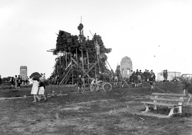
Photograph, Bonfire, Beckett Park, Balwyn (Surrey Hills), c1937/8, 1937
... CELEBRATIONS IN 1930s/ The celebrations were centred on the/ shopping... CELEBRATIONS IN 1930s/ The celebrations were centred on the/ shopping ..."The bonfire at Beckett Park was the culmination of the EMPIRE DAY/CELEBRATIONS in Surrey Hills in 1935 and 1936. In 1937 vandals lit the fire prematurely but residents hastily rebuilt it - about / 100 tons including old tyres. A volunteer fire-watcher had his caravan close by until lights-up time on Saturday night. / Courtesy Ian Barkla. / see 180 (handwritten on backing board)." / "BONFIRE BUILDING at BECKETT PARK/EMPIRE DAY CELEBRATIONS IN 1930s/ The celebrations were centred on the/ shopping centres in Surrey Hills and/Mont Albert to boost local business (and/ the spirits of residents) after the Depression./ - from a glass negative - Mr Ian Barkla."Image depicting the building of a large bonfire made primarily from rubber tyres, supported by a wooden frame c1937/8. There is a significant crowd of people watching the erection of the pyre from ground level. Several members of the crowd are seated or holding bicycles. There are multiple persons situated on the pyre or on a ladder propped up against the mound of tyres. The area containing the pyre has been fenced off with rope (?). A white coloured caravan in situated to the right (facing) of the bonfire in close proximity to a dark coloured car. Two stone towers and a park bench are also visible in the image.Black and white, W 25.3 cm x H 20.3 cm, landscapeparks and reserves, beckett park, balwyn, bicycles, crowds, empire day, depression 1929-1939, economic depression, frank leslie barkla, bonfires -
 Melbourne Tram Museum
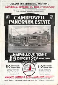
Ephemera - Real estate sale, Cranny Sambell & Co, "Camberwell Panorama Estate", Oct. 1923
... terms of sale, photos showing the views and a nearby shopping... of sale, photos showing the views and a nearby shopping centre ...Pamphlet advertising the sale of land at the "Camberwell Panorama Estate" - Doncaster and Bulleen Road 13-10-1923. Gives terms of sale, photos showing the views and a nearby shopping centre. Has a large photo of MMTB No. 20 on the front cover. The tramcar is of the Hawthorn Tramways Trust four-door bogie type. MMTB No 20 was an ex-Prahran and Malvern single trucker or small tram A class. Gives details of the 110 lots to be sold, terms, location, and that the tram was proposed to be extended to the corner. This extension took place in 1937. The locality plan shows proposed plans for tram lines in Belmore Road and Burke Road north of Whitehorse Road. Demonstrates the style of land sale pamphlet including the availability of tram services to prospective purchasers.Pamphlet - folded - printed in two colours of cream coloured paper with photographs and plans.has pencil notes on the top of the front page.sale of land, trams, real estate, camberwell panorama estate, east camberwell, doncaster road, bulleen road, tram 20 -
 Ringwood and District Historical Society
Newspaper, Scrapbook Clipping, Library Collection, Ringwood, Victoria, `
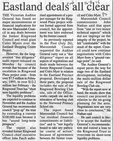
... Coles Myer over the Eastland Shopping Centre Project. Howevber... the Eastland Shopping Centre Project. Howevber, the long awairted "Due ...``Newspaper clipping from "The Post"16-8-95, P 3. Eastland deals all clear The Victorian Auditor General has found no major inconsistencies or financial implications for the new Maroondah Council in any deals between the former Ringwood Council and retail giant Coles Myer over the Eastland Shopping Centre Project. Howevber, the long awairted "Due diligence" report rel;eased on Monday by council reveals that because of the escalation in Ringwood Plaza project costs - from over $7.5 million in February 1993, to over 12.2 million last February - the Ringwood Trust has "short term liquidity problems".` -
 Greensborough Historical Society
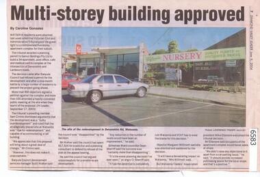
Newspaper Clipping, Multi-storey building approved, by Caroline Gonzalez, 2003_09
... building comprising apartments, shops, medical centre and cafe... an application to build a 5 storey building comprising apartments, shops ...In 2003, VCAT approved an application to build a 5 storey building comprising apartments, shops, medical centre and cafe on a site on the corner of Lambourn and Devonshire Roads Watsonia, despite strong local opposition. The proposal did not proceed, but a new proposal was approved in 2019. News clipping, text and colour image. Copy 2 has note attached.watsonia, devonshire road watsonia, lambourn road watsonia -
 Eltham District Historical Society Inc
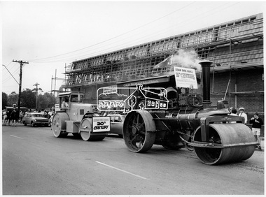
Photograph, Steam Roller and Diesel Roller. Procession of Floats Eltham, 10 Apr 1971
... The Procession of floats travelled from the Eltham Shopping... Shopping Centre to Eltham Lower Park on Saturday 10th April as part ...The Procession of floats travelled from the Eltham Shopping Centre to Eltham Lower Park on Saturday 10th April as part of the Shire of Eltham centenary celebrations program. A steam Roller and diesel roller. One of a series of three photgraphs. Participants in the parade included the Eltham Film Society, Scout group, Eltham volunteer fire brigade, riders on horses and horse and carts. A cowley roller from the Melbourne Steam traction engine club and a McDonald roller represented Eltham Shire Council in the 19th and 20th centuries. Another float includes a bark hut with trailer representing pioneers with a banner reading "The trues heroes our pioneers". Eltham Village is under construction by H.M. Keast & Sons, Master Builders. This photo forms part of a collection of photographs gathered by the Shire of Eltham for their centenary project book, "Pioneers and Painters: 100 years of the Shire of Eltham" by Alan Marshall (1971). The collection of over 500 images is held in partnership between Eltham District Historical Society and Yarra Plenty Regional Library (Eltham Library) and is now formally known as 'The Shire of Eltham Pioneers Photograph Collection.' It is significant in being the first community sourced collection representing the places and people of the Shire's first one hundred years.Digital imagesepp, shire of eltham pioneers photograph collection, shire of eltham, shire of eltham centenary, centenary celebrations, parade floats, parade, diesel roller, steam roller, h & m keast & sons, eltham village, main road, eltham, melbourne steam traction club -
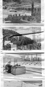 Kiewa Valley Historical Society
Postcard - Mt Beauty and the Kiewa Hydro Electric Scheme
... Beauty Village Shopping Centre 8. Switchyard, No. 4 Power Station.... junction Dam, Bogong 7. Mt Beauty Village Shopping Centre 8 ...SECV constructed the Kiewa Hydro Electric Scheme including the township of Mt Beauty. The area became a popular tourist destination.Tourism in the Kiewa Valley especially at Mt Beauty and the Bogong High Plains along with the Kiewa Hydro Electric Scheme became very popular and an important industry.Fold out b & w postcard with 12 photos back to back. All with a title. Kate 1950s 1. High Voltage Transmission Line, showing Mount Beauty Township 2. Clover Dam Reservoir, Kiewa 3. No. 3 Power Station, Kiewa 4. Generators, No. 3 Power Station 5. Turbines, No. 4 Power Station, Kiewa 6. junction Dam, Bogong 7. Mt Beauty Village Shopping Centre 8. Switchyard, No. 4 Power Station, Kiewa 9. Control Room, No. 4 Power Station, Kiewa 10. Winter Scene at Rocky Valley on the Bogong High Plains 11. Water Channel, Mt Bogong in Background 12. Mt Beauty Township, Kiewa Valleytransmission line, power station, generators, mt beauty, turbines, junction dam, switchyard, rocky valley, control room -
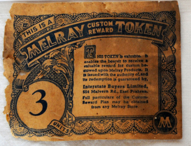 Orbost & District Historical Society
token, mid 20th century
... discovered there, when the site was converted to a shopping centre... discovered there, when the site was converted to a shopping centre ..." As well as preserving companies, various grocery chains, buying groups and wholesale co-operatives sold jam under their own brand names. One such company was Melray. Melray, founded in East Prahran, Melbourne, in 1932, was the forerunner of the Foodland chain (1958). It had branches across the country. Their jam labels included special reward tokens for redemption in-store. It is most likely that Melray jam was produced by Henry Jones’ Australasian Jam Company, or at least labelled at the iconic Jam Factory in South Yarra, Melbourne – a site of jam production in Australia for almost 100 years. Many Melray labels were discovered there, when the site was converted to a shopping centre in the 1970s, a period of industry-wide decline." (Information from australiapostcollectables web-site) The Melray Association of Independent Grocers consisted of the leading storekeepers throughout the State of Victoria, with a central headquarters and bulk store in Melbourne.These tokens were issued by Melray Stores as a reward for custom. This item is associated with the period when Australia produced and exported much more of its agricultural produce - including tinned jam.A paper token - Melray Custom Reward Token. This is a reward token issued by Melray for regular custom - 3 units.melray grocery-store custom commerce -
![Photograph - Digital image, House St Helena and Diamond Creek Roads [Greensborough], 02/05/2013](/media/collectors/4f729f5697f83e03086015b8/items/5729bbd22162f108e8de5be2/item-media/5729bc112162f108e8de617d/item-fit-380x285.jpg) Greensborough Historical Society
Greensborough Historical SocietyPhotograph - Digital image, House St Helena and Diamond Creek Roads [Greensborough], 02/05/2013
... the Main Street shopping centre, new and old bridges, new roads... from the high verandah encompasses the Main Street shopping ...These photographs of the house on the corner of St Helena and Diamond Creek Roads was taken in 2013 to show changes over 40 years, based on Ron Reynold's sketches in the 1973 publication 'Greensborough and Greenhills' published by Cypress Books... which states "Built on a steep hill in a bush setting in the early 1920s, for a Dr Wood, the weatherboard house now overlooks an area of activity and change. The owners, Mr and Mrs E. 'Bluey' Blackburn, remember when their 3/4 acre building block dropped to the edge of a dirt road. Today the view from the high verandah encompasses the Main Street shopping centre, new and old bridges, new roads and houses, the Plenty River, natural bush, hills and sports grounds."Digital copy of colour photograph.greensborough and greenhills, st helena road greensborough, diamond creek road greensborough, wood family, ron reynolds