Showing 10763 items
matching site
-
 Kiewa Valley Historical Society
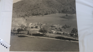
Photo - Tawonga Sawmill
Photo of the Tawonga Sawmill at Tawonga. It was operated by Mt Beauty Timbers P/L circa 1960s. Prior to transfer to Mt Beauty site.The Mt Beauty Timber mill closed in the 1990s due to changes to government legislation regarding logging in the National Park.Black/grey and white aerial photo of the Tawonga Mill site circa 1960s.tawonga sawmill, mt beauty timbers pty ltd, logging -
 Flagstaff Hill Maritime Museum and Village
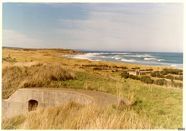
Photograph - Historical, Flagstaff Hill, Warrnambool Garrison Fortifications looking towards the Moyjil (Point Ritchie), 1970s
The photograph shows the location of the concrete, horseshoe shaped gun emplacement erected for the cannons. It is part of the Historic Precinct on Flagstaff Hill. The area was accessed either through the space between the Lighthouses (through the cottage grounds) or a service entrance, past the iron huts used by the Lands Department. This photograph, a print, is one of a set of five that show the site of Flagstaff Hill. It is presumed to have been taken by John Lindsay, Founding Director of Flagstaff Hill Maritime Museum and Village. One of the photographs in the set has the pencil inscription "Photo J Lindsay". It was taken in the early 1970s during the initial stages of the development of Flagstaff Hill as a Museum and Maritime Village. The photographs belonged to the donor's grandparents, who lived in the Warrnambool district of Allansford/Naringal. The photograph is a record of the site and surrounds of Flagstaff Hill Maritime Museum and Village before its development and opening in 1975. It shows the east side of the Surfside Holiday Park in its earlier days. The photograph is significant for recording the location and condition of the original concrete cannon emplacement on the Hill.Coloured photograph, glassy print, one of a set of five. Photograph shows the original site of one of the gun emplacements for the cannons, cannons Historical, looking towards the Moyjil, ,Point Ritchie and overlooking Lady Bay, Warrnambool. The horseshoe shaped concrete gun emplacement is in the foreground on the grassed slopes overlooking the Bay. The site and ablution block of the Surfside Holiday Park is centre right. The left shows the sore of Lady Bay with the cliffs of the Southern Ocean in the distance. The photograph's paper has the printer's watermark on the back. The early 1970s scene is presumed to have been photographed by John Lindsay, Warrnambool.Label on the back: "FIRST GUN EMPLACEMENT LOOKING TOWARDS THE HOPKINS / This is the original site of one of the cannons overlooking the Bay. Access to this area could be between the light-houses (throught the cottage grounds), or a service entrance - past the iron huts used by Lands Department."flagstaff hill, flagstaff hill maritime museum and village, warrnambool, maritime museum, maritime village, great ocean road, shipwreck coast, 1970s, photograph, gun emplacement, surfside holiday park, lady bay, hopkins river, flagstaff hill site, john lindsay, concrete gun emplacement, cannon emplacement, original emplacement -
 Whitehorse Historical Society Inc.
Document - Pamphlet, Blackburn - a mural depicting its history, 1996
Leaflet describing a mural sponsored by Blackburn Library Arts ProjectLeaflet describing a mural sponsored by Blackburn Library Arts Project depicting 33 local people, places and sites.Leaflet describing a mural sponsored by Blackburn Library Arts Project blackburn, murals, landcare and environment action group program, blackburn library arts program -
 Hume City Civic Collection
Photograph, c late 1990s
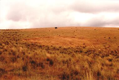
The series of 9 photographs were taken to be included in a study of archaeological sites and Aboriginal rings in the Sunbury area. Five earth rings which are thought to be associated with male initiation ceremonies have been identified in Sunbury. Only 3 others have been found in the rest of Victoria. Despite rapid development in the area, those sites are protected heritage sites.A coloured photograph of an Aboriginal Ring which is a proclaimed sacred site on an open grassy hillside. A black cow is standing in the distance.aboriginal culture, aboriginal rings, sacred sites, george evans collection -
 Hume City Civic Collection
Photograph, c late 1990s
The series of 9 photographs were taken to be included in a study of archaeological sites and Aboriginal rings in the Sunbury area. Five earth rings which are thought to be associated with male initiation ceremonies have been identified in Sunbury. Only 3 others have been found in the rest of Victoria. Despite rapid development in the area, those sites are protected heritage sites.A view of the Aboriginal ring and sacred site and its close proximity to a proposed housing estate at Sherwood near Racecourse Road.aboriginal culture, aboriginal rings, sacred sites, george evans collection -
 Kiewa Valley Historical Society
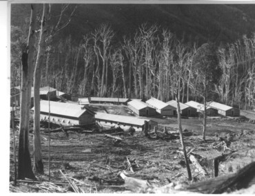
Photograph of Howmans Dam Camp, Howmans Dam Camp, circa 1948
Howman's Gap camp was erected in 1948. The proposed dam to be built at this site was postponed in 1954 because of financial restraints imposed by the government at this time. It was to have supplied water for No. 2 Power Station at the Junction of the Pretty Valley and Rocky Valley branches of the East Kiewa River. This power station was not constructed until 2008 - 2010 and now gets it water from McKay Creek Power Station. The site of this camp is now occupied by the Howman's Gap Alpine Centre. Some of the original buildings still remain. An excellent photographic record of the type of buildings and size of the camp for accommodation of workmen during construction of the Kiewa Hydro Electric Scheme.Black and white photograph of the buildings erected at Howmans Dam site as accommodation for workmen.Handwritten in blue ink on the back of photograph "Howmans Dam Camp"howman's gap, camp, water, dam -
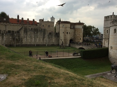 Ballarat Heritage Services
Digital photograph, Dorothy Wickham, Tower of London, 2016
The Tower of London, officially Her Majesty's Royal Palace and Fortress of the Tower of London, is a historic castle located on the north bank of the River Thames in central London. It lies within the London Borough of Tower Hamlets, separated from the eastern edge of the square mile of the City of London by the open space known as Tower Hill. It was founded towards the end of 1066 as part of the Norman Conquest of England. The White Tower, which gives the entire castle its name, was built by William the Conqueror in 1078, and was a resented symbol of oppression, inflicted upon London by the new ruling elite. The castle was used as a prison from 1100 (Ranulf Flambard) until 1952 (Kray twins),[3] although that was not its primary purpose. A grand palace early in its history, it served as a royal residence. As a whole, the Tower is a complex of several buildings set within two concentric rings of defensive walls and a moat. There were several phases of expansion, mainly under Kings Richard the Lionheart, Henry III, and Edward I in the 12th and 13th centuries. The general layout established by the late 13th century remains despite later activity on the site. The Tower of London has played a prominent role in English history. It was besieged several times, and controlling it has been important to controlling the country. The Tower has served variously as an armoury, a treasury, a menagerie, the home of the Royal Mint, a public record office, and the home of the Crown Jewels of England. From the early 14th century until the reign of Charles II, a procession would be led from the Tower to Westminster Abbey on the coronation of a monarch. In the absence of the monarch, the Constable of the Tower is in charge of the castle. This was a powerful and trusted position in the medieval period. In the late 15th century the castle was the prison of the Princes in the Tower. Under the Tudors, the Tower became used less as a royal residence, and despite attempts to refortify and repair the castle its defences lagged behind developments to deal with artillery. The peak period of the castle's use as a prison was the 16th and 17th centuries, when many figures who had fallen into disgrace, such as Elizabeth I before she became queen, Sir Walter Raleigh, and Elizabeth Throckmorton were held within its walls. This use has led to the phrase "sent to the Tower". Despite its enduring reputation as a place of torture and death, popularised by 16th-century religious propagandists and 19th-century writers, only seven people were executed within the Tower before the World Wars of the 20th century. Executions were more commonly held on the notorious Tower Hill to the north of the castle, with 112 occurring there over a 400-year period. In the latter half of the 19th century, institutions such as the Royal Mint moved out of the castle to other locations, leaving many buildings empty. Anthony Salvin and John Taylor took the opportunity to restore the Tower to what was felt to be its medieval appearance, clearing out many of the vacant post-medieval structures. In the First and Second World Wars, the Tower was again used as a prison, and witnessed the executions of 12 men for espionage. After the Second World War, damage caused during the Blitz was repaired, and the castle reopened to the public. Today the Tower of London is one of the country's most popular tourist attractions. Under the ceremonial charge of the Constable of the Tower, it is cared for by the charity Historic Royal Palaces and is protected as a World Heritage Site.(Wikipedia) A World Heritage Site is a landmark which has been officially recognized by the United Nations, specifically by UNESCO. Sites are selected on the basis of having cultural, historical, scientific or some other form of significance, and they are legally protected by international treaties. UNESCO regards these sites as being important to the collective interests of humanity. More specifically, a World Heritage Site is an already classified landmark on the earth, which by way of being unique in some respect as a geographically and historically identifiable piece is of special cultural or physical significance (such as either due to hosting an ancient ruins or some historical structure, building, city, complex, desert, forest, island, lake, monument, or mountain) and symbolizes a remarkable footprint of extreme human endeavour often coupled with some act of indisputable accomplishment of humanity which then serves as a surviving evidence of its intellectual existence on the planet. And with an ignoble intent of its practical conservation for posterity, but which otherwise could be subject to inherent risk of endangerment from human or animal trespassing, owing to unmonitored/uncontrolled/unrestricted nature of access or threat by natural or accelerated extinction owing to local administrative negligence, hence it would have been listed and demarcated by the United Nations Educational, Scientific and Cultural Organization (UNESCO) to have been identified or recognised and officially christened and internationally elevated through multilateral declaration by UNESCO as a universally protected zone. [1] The list is maintained by the international World Heritage Programme administered by the UNESCO World Heritage Committee, composed of 21 UNESCO member states which are elected by the General Assembly. (Wikipedia)The Tower of London is a UNESCO world heritage site.tower of london -
 Whitehorse Historical Society Inc.
Photograph, Stanley Works, c1972
In 1970 - Titan Pty Ltd acquired Turner Industries of Nunawading (Turner had commenced making tools there in 1936). In 1971 the Stanley Works was formed from Stanley-Titan and Turner Industries. Stanley Works ceased manufacture on the Nunawading site in 1992. The site now belongs to Harvey NormanBlack and white photo c1972 of Stanley Works, Whitehorse Road, Nunawading. Now the site of Harvey Normanstanley works pty ltd, tools -
Whitehorse Historical Society Inc.
Document, 56-74 Station Street Nunawading, 2013
Major commercial property sale, 394 x 164 metres, sold for $22,000,000. The site is expected to be vacated in April 2015.Major commercial property sale, 394 x 164 metres, sold for $22,000,000. The site is expected to be vacated in April 2015.Major commercial property sale, 394 x 164 metres, sold for $22,000,000. The site is expected to be vacated in April 2015.station street nunawading, nos.56-74, daniel robertson australia pty ltd., brickworks -
Whitehorse Historical Society Inc.
Article, $3.4 million road development opened
Article about the opening of home units for the agedArticle about the opening of home units for the aged in the former migrant hostel site in Rooks Road, Nunawading. With photo.Article about the opening of home units for the agedretirement homes and villages, harrowfield, john, mccutcheon, andrew, bradley, norman, bradley, agnes, rooks road, nunawading -
 Whitehorse Historical Society Inc.
Photograph, Vermont Primary School
In 1872, pupils began the school year in the building. By 1958 a new site opened in Nurlendi Road, Vermont. After standing derelict for many years, the old Vermont Primary School was moved to the Nurlendi site in 1992Coloured photo of Vermont Primary School No.1022 on the original site on the north-west corner of the junction of Mitcham and Canterbury Roads.vermont primary school no.1022, primary schools -
Whitehorse Historical Society Inc.
Article, Plans To Consolidate Three Campuses, 21/09/1994 12:00:00 AM
Article on the consolidation of Millauna Secondary Colleges, three campuses on to one site at Mitcham Road, due to operate in 1996.Article on the consolidation of Millauna Secondary Colleges, three campuses on to one site at Mitcham Road, due to operate in 1996.Article on the consolidation of Millauna Secondary Colleges, three campuses on to one site at Mitcham Road, due to operate in 1996.secondary schools, millauna secondary college -
Glenelg Shire Council Cultural Collection
Photograph - Photograph - Main Breakwater construction, Portland, n.d
Port of Portland Authority Archivesport of portland archives, main breakwater, construction, portland, harbour, concrete, workmen, site -
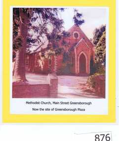 Greensborough Historical Society
Photograph, Unknown, Methodist Church Main Street Greensborough, 1940c
The Greensborough Methodist Church stood in Main Street Greensborough and was central to the social life of the suburb in the early 20th century. This original site is now part of the Greensborough Plaza shopping complex. The Church moved to the new building in Grimshaw Street circa 1970s. This photograph shows the red brick church, now demolished.Copy of colour photograph of red brick church, mounted on yellow card and laminated.Caption: 'Methodist Church, Main Street Greensborough. Now the site of Greensborough Plaza'methodist church greensborough -
Whitehorse Historical Society Inc.
Map, Kylana Estate Tunstall, 1926
Auctioneer's plan of sub-division of Kylana Estate Tunstall.Auctioneer's plan of sub-division of Kylana Estate Tunstall, 8 sites, 2nd Oct 1926. Auctioneer: Sergeant & LehmannAuctioneer's plan of sub-division of Kylana Estate Tunstall.heather grove tunstall, kylana estate, springvale road tunstall, tunstall -
 Melbourne Tram Museum
Document - Notice to Employees, Yarra Trams, "Kooyong Rail Square - Operating Procedure", Jan 2008
Document provides information on the operation of the rail square (also known as a tram square, railway Square) at the Kooyong Glenferrie Road level crossing. Provides a site plan, signal information and operational procedures including when items fail. Dated 16/1/2008.Demonstrates an instruction into the operation of the Kooyong rail squareSingle A4 sheet, printed double sided, with a coloured site plan.trams, tramway square, rail square, railway square, glenferrie road, kooyong level crossing, operations, instructions -
 Lakes Entrance Historical Society
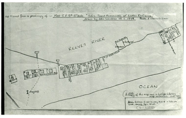
Photograph - New Works Plan, 1898
Map traced from a photocopy of :- Map TP8A Bairnsdale. 'Site. Sand Hummocks of Lakes Entrance'. Drawn by John Lardner 18 January 1898. Scale two chains to one inch. ( A photocopy of this map in Latrobe Library map collection, June 1983)Black and white photograph showing sketch map of 1898 by John Lardner Plan of Sites - sand hummocks. Drawing shows sites of buildings at entrance along Cunninghame Arm shoreline at Lakes Entrance, Victoria.land settlement, plan -
Whitehorse Historical Society Inc.
Article, Grant To Improve Mullauna College, 5/07/2000 12:00:00 AM
Article on State Government's $3.7 million grant to consolidate the three campuses of Millauna Secondary College oneArticle on State Government's $3.7 million grant to consolidate the three campuses of Millauna Secondary College at one site on Mitcham Road by 1996.Article on State Government's $3.7 million grant to consolidate the three campuses of Millauna Secondary College one secondary schools, millauna secondary college -
Whitehorse Historical Society Inc.
Pamphlet, Green-Brae Estate, 1956
Photocopy of advertisement for the sale of Green-Brae Estate, Springvale Road, Nunawading.Photocopy of advertisement for the sale of Green-Brae Estate, Springvale Road, Nunawading. Comprises 53 home sites. Agent: Weston & Heath.Photocopy of advertisement for the sale of Green-Brae Estate, Springvale Road, Nunawading.land subdivision, green-brae estate nunawading, springvale road, nunawading, brae grove, nunawading, nielsen avenue, nunawading, gladys street, nunawading, lynne court, nunawading -
 Federation University Historical Collection
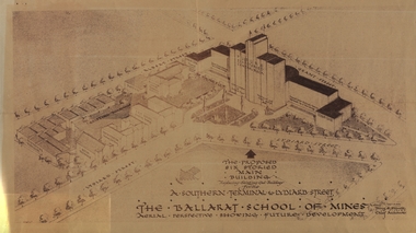
Plan - Architectural Drawing, Ballarat School of Mines: The Proposed Six Storied Main Building, 5 December 1947
Drawing of the School of Mines site showing the proposed six storied Main Building to replace the existing historical gaol building. This was never built. This was sent to Jack Barker in 1970 by Jim Docherty. He was a member of the Board of Technical School Inspectors, Education DepartmentDrawing of the propose six storied main building for the School of Mines site, Ballarat.ballarat school of mines, historic buildings, percy everett, architect, architectural drawing, jack barker, jim docherty, education department -
 Marysville & District Historical Society
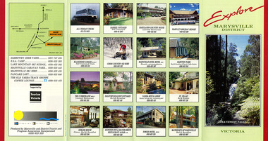
Ephemera (Item) - Information brochure, Marysville and District Tourist and Progress Association, Explore MARYSVILLE DISTRICT, Unknown
An information brochure with photographs of accommodation sites and businesses in Marysville as well as activities to experience in and around Marysville. This brochure was produced by the Marysville & District Tourist & Progress Association with the support of Tourism Victoria.An information brochure with photographs of accommodation sites and businesses in Marysville as well as activities to experience in and around Marysville.Supported by/ Victorian/ Tourism/ Commission Produced by Marysville/ and District Tourist and Progress Association Incorporatedmarysville, victoria, australia, information brochure, all terrain tours, baree cottages, marylands country house, may-yn holiday resort, blackwood lodges, cross country ski hire, marysville hotel motel, maryton park, the cumberland, dalrymples guest cottages, nanda binya lodge, st fillan, kerami house, kufstein inn, silver birch restaurant and bar, tower motel, mathilde's of marysville, steavenson falls, marysville and district tourist and progress association incorporated, tourism victoria, darrowby deer farm, esa camp, lake mountain ski school, marysville caravan park, marysville ski hire, pancake loft, the old yarra track shoppe -
 Marysville & District Historical Society
Ephemera (Item) - Information brochure, Marysville and District Tourist and Progress Association, Explore MARYSVILLE DISTRICT, Unknown
An information brochure with photographs of accommodation sites and businesses in Marysville as well as activities to experience in and around Marysville. This brochure was produced by the Marysville & District Tourist & Progress Association with the support of Tourism Victoria.An information brochure with photographs of accommodation sites and businesses in Marysville as well as activities to experience in and around Marysville.Supported by/ Victorian/ Tourism/ Commission Produced by Marysville/ and District Tourist and Progress Association Incorporatedmarysville, victoria, australia, information brochure, all terrain tours, baree cottages, marylands country house, may-yn holiday resort, blackwood lodges, cross country ski hire, marysville hotel motel, maryton park, the cumberland, dalrymples guest cottages, nanda binya lodge, st fillan, kerami house, kufstein inn, silver birch restaurant and bar, tower motel, mathilde's of marysville, steavenson falls, marysville and district tourist and progress association incorporated, tourism victoria, darrowby deer farm, esa camp, lake mountain ski school, marysville caravan park, marysville ski hire, pancake loft, the old yarra track shoppe -
 Lakes Entrance Historical Society
Photograph, 2008
The pharmacy building has since been removed from this site, it is now vacant. The pharmacy is now situated in the Safeway Arcade.Colour photograph of the pharmacy situated in a temporary building on Esplanade. This site was originally the Kiora Guesthouse. Lakes Entrance Victoriaarchitecture, township, tourism, room display -
 Kew Historical Society Inc
Photograph - Tree in St Anthony's Place, Kew, c.2009
St Anthony's Place in Kew was a late 20th century urban development on the site previously occupied by the early Kew mansion 'Elm Place' (later 'Madford', then 'St Anthony's Home for Babies'.) The donor of the photograph believed that the tree dated from the nineteenth century garden of 'Elm Place'.Colour photo of a tree behind a house on site of St Anthony's Home for Babies.trees -- kew (vic), st anthony's place -- kew (vic.) -
Clunes Museum
Article - BRASS CHAIN (SMALL PIECE)
SMALL SECTIONS OF CHAIN WAS COLLECTED FROM THE CHURCH SITE - POSSIBLY CLUNES CHURCH OF ENGLAND APPROX. 1887.TWO SMALL SECTIONS BRASS CHAIN COLLECTED FROM CLUNES CHURCH SITE - P0SSIBLY ST.PAULS CHURCH OF ENGLAND 1989.local history, metal craft, brassware, churches - st.pauls anglican -
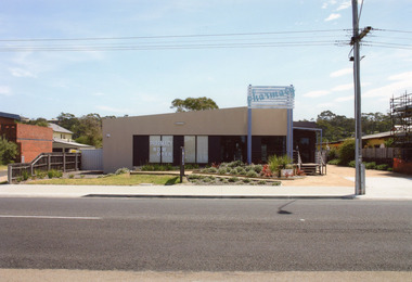
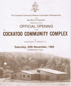 Cockatoo History & Heritage Group
Order of Ceremony, Official Opening of the Cockatoo Community Complex, Saturday 20th November, 1982
In 1976, the Shire of Pakenham recognising that Cockatoo was the second largest township within the shire, acknowledged requests for the provision of recreation facilities. Council purchased four hectares of land strategically located in the Town Centre and in conjunction with the local community, embarked upon a programme of staged development of the site. The first stage saw the construction of the kindergarten building which was opened in 1977, followed by the bowling green, tennis courts, netball courts and public toilets. The Community Complex Building was the final development of the site.The Cockatoo Community Complex building, was the final stage of the development and was opened on the 20th November 1982. It was a replacement for the old Cockatoo Hall, which had not been renovated since 1936. The old Cockatoo Hall was lost in the Ash Wednesday fires on the 16th February 1983. The community complex played an integral part in the recovery stages after Ash Wednesday.Four page document, including Acknowledgements, Order of Ceremony, Menu and Site Plan of the Cockatoo community ComplexTwo punctured holes for folder storagecockatoo community complex, cockatoo hall, hall opening, cockatoo -
 Whitehorse Historical Society Inc.
Photograph, Vermont Primary School
The Vermont Primary School No.1022 began operating in 1882. By 1958 a new school was built in Nurlendi Road, Vermont. After standing derelict for many years, the school was moved to the Nurlendi Road site in 1992Coloured photograph of a section of the original Vermont Primary School building, now on the Nurlendi Road sitevermont primary school no. 1022, schools -
 Ringwood and District Historical Society
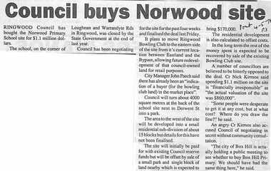
Newspaper, Scrapbook Clipping, Library Collection, Ringwood, Victoria, `
``Newspaper clipping from "The Post" 4-5-94 P 3 Council buys Norwood siteRingwood Council has bought the Norwood Primary School for $1.1 million dollars. The school, on the corner of Loughnan and Warrandyte Roads in Ringwood was closed by the government at the end of last year. A number of councillors are believed to be bitterly opposed to the deal. Cr Nick Kirmos said spending $1.1 million is "financially irresponsible" as "the actual valuation of the site is $860,000"` -
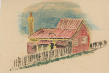 Lakes Entrance Historical Society
Drawing, Allan Freeman, Historic House Lakes Entrance, 1920 c
This house was floated across to the site from the New Works. We don't have a photograph of this house. A coloured drawing of Joe Picketts house which was once situated behind the site of present National Bank Lakes Entrance Victoriabuildings, houses, people