Showing 710 items
matching south gippsland
-
 South Gippsland Shire Council
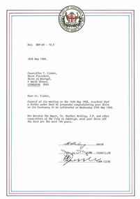
Letter, 18/5/1988
... South Gippsland Shire Council 9 Smith Street Leongatha ...Typed letter from the City of Oakleigh to Shire of Woorayl congratulating them on its centenary to be celebrated on Wednesday 25th May 1988. Signed by the Mayor, Councillor & Town Clerk. Tri-colour border with shire crest at top. Note: Item approved for deaccession August 2023. SGSC will now follow deaccession procedures as outlined in the Arts and Civic Memorabilia Collection Policy - https://www.southgippsland.vic.gov.au/downloads/file/2763/arts_and_artefacts_collection_policy_c69. -
 South Gippsland Shire Council
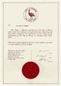
Letter, 2/5/1988
... South Gippsland Shire Council 9 Smith Street Leongatha ...Letter to Woorayl Shire from the City of Burnie thanking Shire for their best wishes on occasion of Proclamation of City of Burnie on 29 April 1988. Sealed with Common Seal and signed by two aldermen and Town Clerk. Dated 2 May 1988. Note: Item approved for deaccession August 2023. SGSC will now follow deaccession procedures as outlined in the Arts and Civic Memorabilia Collection Policy - https://www.southgippsland.vic.gov.au/downloads/file/2763/arts_and_artefacts_collection_policy_c69. -
 South Gippsland Shire Council
Photograph
... South Gippsland Shire Council 9 Smith Street Leongatha ...Framed colour photograph of a couple sitting on beach with cliffs showing in right side. Brown timber frame. Note: Item approved for deaccession August 2023. SGSC will now follow deaccession procedures as outlined in the Arts and Civic Memorabilia Collection Policy - https://www.southgippsland.vic.gov.au/downloads/file/2763/arts_and_artefacts_collection_policy_c69. -
 South Gippsland Shire Council
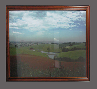
Photograph
... South Gippsland Shire Council 9 Smith Street Leongatha ...Framed colour photograph featuring a landscape showing low hills, ploughed paddock in foreground and dams in centre. Brown timber frame. Note: Item approved for deaccession August 2023. SGSC will now follow deaccession procedures as outlined in the Arts and Civic Memorabilia Collection Policy - https://www.southgippsland.vic.gov.au/downloads/file/2763/arts_and_artefacts_collection_policy_c69. -
 South Gippsland Shire Council
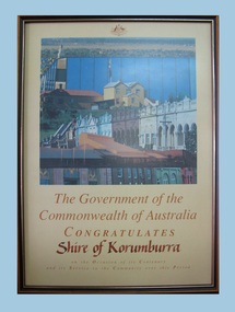
Certificate
... South Gippsland Shire Council 9 Smith Street Leongatha ...Framed certificate featuring colour photograph of building possibly early Canberra. Set in brown wood frame with gold edge. Cream background. Text in brwon ink. Handwritten words: "Shire of Korumburra" Note: Item approved for deaccession August 2023. SGSC will now follow deaccession procedures as outlined in the Arts and Civic Memorabilia Collection Policy - https://www.southgippsland.vic.gov.au/downloads/file/2763/arts_and_artefacts_collection_policy_c69. -
 Old Gippstown
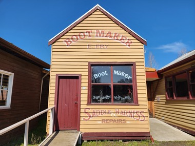
Building - Bootmaker and Saddler, 1906
Built in 1906 in main street of Neerim South by Samuel Fry who established his business at that time. Exhibits include early boots and shoes, Heavy leather working machines and saddlery. Many of the tools belonged to Harry Coombs, who was Moe's first bootmaker from 1910 - 1966A small rectangular timber shop. The front has a gabled corrugated iron roof, while the workshop at the rear of the shop is not as high as the front and has a flat corrugated iron roof.Sign writing on shop frontbootmakers, neerim south, samuel fry, harry coombs, old gippstown, west gippsland, gippsland, gippsland heritage park, goldfields, coal mine, victorian era, moe, historical village, baw baw shire, saddlery, leather work, old gippstown heritage park, latrobe valley, latrobe city council -
 South Gippsland Shire Council
Framed lithograph featuring Agnes River, Corner Inlet, Gippsland, 1983
... South Gippsland Shire Council 9 Smith Street Leongatha ...Framed lithograph featuring Agnes River, Corner Inlet, Gippsland. Drawn from nature and lithographed by Nicholas Chevalier. -
 Lakes Entrance Regional Historical Society (operating as Lakes Entrance History Centre & Museum)
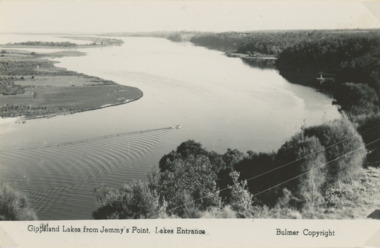
Photograph - Jemmys Point Lakes Entrance, Tidy Town Committee, 1996 c
Also a second similar photograph number 03875.1 size 10 x 15 cmColour photograph taken from Jemmys Point looking west through the Gippsland Lakes to Metung with Rigby, Fraser and Flannagan Islands to the south Kalimna Victoriaaerial photograph, township, topography, waterways, jemmys point lakes entrance -
 Bendigo Historical Society Inc.
Document - ROYAL HISTORICAL SOCIETY OF VICTORIA - MEETING MINUTES - 16/02/1985, 16 Feb 1985
Document. Four-page copy of the minutes of the quarterly meeting of the State Committee of Member Societies. Meeting held on 16 Feb. 1985 at the headquarters of the Royal Historical Society of Victoria, 1 City Road, South Melbourne. Apologies recorded from Miss F Kingerlee of the Bendigo Branch. On top left of front page handwritten in red biro 'Alec H Stone'.Mr J Irving (Gippsland) Chairmandocument, royal historical society of victoria, meeting minutes, miss f kingerlee, alec h stone. -
 Lakes Entrance Regional Historical Society (operating as Lakes Entrance History Centre & Museum)
Photograph - Rotary, Lakes Post Newspaper, 1999
Colour photograph Rotary Club member Mike Anketell with Tim Bull, Editor of South East Fishing magazine, of East Gippsland Newspapers. Lakes Entrance Victoriarotary club, volunteering -
Lakes Entrance Regional Historical Society (operating as Lakes Entrance History Centre & Museum)
Book, Lee, Timothy and Turpin, Barrie, Portraits. Remarkable people of South Eastern Australia, 1991
Personal records of twenty-six residents of East Gippsland, Victoria, captured in print and photographs. Lives and legends from a vanishing breed of people that have helped shape the fact of Australia.settlers, agriculture, aboriginals -
 Bendigo Historical Society Inc.
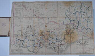
Document - HARRIS COLLECTION: HAMS SQUATTING MAP OF VICTORIA, PORT PHILLIP DISTRICT, NSW
Thomas Ham was a cartographer, engraver, lithographer and publisher in Victoria and Queensland. He compiled and printed several editions of his squatting map, beginning with A map of Australia Felix in 1847 and changing its title to Ham's squatting map of Victoria in 1851. The 1851 edition was accompanied by a key listing the names of all the squatters within squatting districts and counties. Later editions show the existing counties, but some areas of Gippsland and the Australian Alps are still described as 'unsurveyed country'. (State Library Victoria https://www.slv.vic.gov.au/squatting-map-victoria)Folding map enclosed in burgundy cover. Map backed by cloth and bound. Rare, early map of Victoria and neighbouring Port Phillip District of New South Wales. Written on bottom RH corner of map: Ham's Squatting Map of Victoria ( Port Phillip District, New South Wales ) carefully corrected to this date from the Colonial Government Surveys, Crown Lands, Commissioners & Explorers Maps, Private Surveys & c. Respectfully inscribed (with permission ) to His Excellency Sir Chas A. Fitz-Roy Knt, Governor of New South Wales &c &c by his Obedient Servant, The Compiler, 1851. Compiled, engraved and published by Thomas Ham, Melbourne. Proposed and original boundary ( in legend) have been coloured in in blue and pink ink ( later addition ?) Number on map show 'reference to proprietor's Printed on back of map ' J.G. AD 1852, with two cross hatched decorations and two hearts entwined. On other back panel in pencil enclosed in a drawn frame ' G.S.H., 1889, Axedale' (George Harris, Axedale, belongs in Harris Collection) Stamped in purple ink 'Royal Historical Society of Victoria, Bendigo Branch. Written 1959, 53.map, victoria, squatting map -
 Victorian Railway History Library
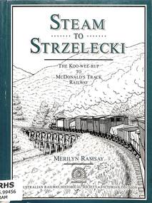
Book, Ramsay, Merilyn, Steam to Strzelecki, 1991
... to McDonald's Track (Strzelecki) Railway in South Gippsland Victoria ...A history of the Koo-Wee-Rup to McDonald's Track (Strzelecki) Railway in South Gippsland Victoria.index, ill, maps, p.150.non-fictionA history of the Koo-Wee-Rup to McDonald's Track (Strzelecki) Railway in South Gippsland Victoria.railroad construction - victoria - history, railroads -- victoria -- gippsland -- history -
 Bendigo Historical Society Inc.
Document - MCCOLL, RANKIN AND STANISTREET COLLECTION: NEW STAR GOLD MINE HARRIETVILLE NL, SOUTH BLUE CONSOLIDATED SYNDICATE
McColl Rankin & Stanistreet, New Star Gold Mine Harrietville NL. Collection of documents in envelope. a/ Agreement with the unregistered mining syndicate South Blue Consolidated Syndicate and Gold Exploration (Victoria) Co ML application No. 9982 for a Gold Mining Lease of land at Bendigo on Southern Extension of the Sheepshead or Red White & Blue Line of Reef. Dated: 17/6/1932. Signatures: James Phillips, Stanistreet, J M Leed, C J Michelsen, Jardine?? MacKay. 2 pages. b/ Harry Raymond Johnson & Ellis Douglas McDonnel Doyle on behalf of a No Liability Company to be formed, application for Gold Mining Lease NO. 7514 (Beechworth). Vendors are taking steps to a Company to be entitled New Star Gold Mine Harrietville. Signed: ??, E? McDoyle, ??, McColl Rankin & Stanistreet, ?? Dated:1/5/19/33. 2 pages. c/ Indenture between Ellis Douglas McDonnell Doyle, Harry Raymond Johnson and New Star Gold Mine Harrietville NL the company was formed on 27/6/1933 registered and incorporated. Dated 28/6/1933. Signed: Ke? E D M Doyle, Murphy, Mary R Johnson, J Nicolsen, G? Stanistreet. 2 pages. d/ Memo attached to 2-page letter. Re: adjustment of number of shares for Mr. King. Letter acknowledging receipt of paid shares. Dated 25/7/1933. Signed C B King,?? Page 2 lists brokerage etc. for shares. Dated 11/7/1933. e/ Memo & 3-page letter. Memo re surveyor for Dargo. Allotted shares exceeds available shares. Letter: To Wonnangatta Gold Reefs Syndicate regarding purchase of lease hold property in Mining District of Gippsland. Dated 28/6/1934. Signed ?? Page 2, Balance of monies advanced from R A Rankin. Page 3, costs Re Golden Butterfly Mine. f/ Agreement to lease property in Mining District of Gippsland Mining Lease No's 5187 & 5195 Black Snake Creek Dargo, blue print map of Mine included of No.5187. Dated 28/6/1934. Signed: Keohan?, ??, G ?, Geo Kingsley, Stanistreet. 4 pages. g/ An option to purchase certain Applications for Gold Mining Leases. Date: 28/6/34. Signitures: ? M Neill, ??, G ?, J Nichelsen, Stanistreet. 2 Pages.bendigo, gold mining, south blue consolidated, mccoll rankin & stanistreet -
 Lakes Entrance Regional Historical Society (operating as Lakes Entrance History Centre & Museum)
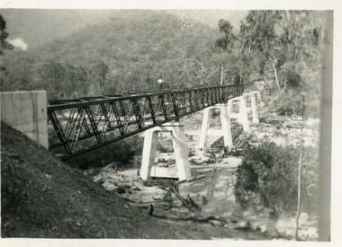
Photograph - Bridges, 1990
Also another photo taken laterColour photograph showing McKillops Bridge across the Snowy River in the High Country near Deddick, East Gippsland near the Victorian / NSW border, south side of bridge, road to Deddick just visible opposite end, taken from west end of bridge. River flowing to right, bridge of timber, steel and concrete, mountains around. East Gippsland Victoriabridges, waterways, topography -
Lakes Entrance Regional Historical Society (operating as Lakes Entrance History Centre & Museum)
Photograph - Snowy River Buchan, 1977 c
Polish scientist explorer Dr. Lhotsky explored the Australian Alps south of Mt Kosciusko (not named at that date)as far as McKillops Bridge (unnamed then) between 1834 and 1839. His claims were largely ignored he being labelled imposter and humbug but recent research indicates his rightful place amongst Victorias early explorersBlack and white photograph of Snowy River at Suggan Buggan VictoriaApproximately where John Lhotsky the first white man known to have been in Gippsland reached the Snowy and spent three days in March 1834topography -
 Lakes Entrance Regional Historical Society (operating as Lakes Entrance History Centre & Museum)
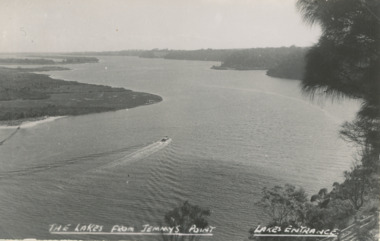
Postcard - Gippsland Lakes, H D Bulmer, Gippsland Lakes from Jemmy's Point, 1927 c
from Jemmys Point looking West showing boat on lake Rigby Fraser and Flannagan Islands to South steep wooded shoreline to North Lakes Entrance VictoriaBlack and white postcard taken from Jemmys Point looking West showing boat on lake Rigby Fraser and Flannagan Islands to South steep wooded shoreline to North Lakes Entrance VictoriaThe Lakes from Jemmys Point Lakes Entrance waterways, boating, islands -
 Lakes Entrance Regional Historical Society (operating as Lakes Entrance History Centre & Museum)
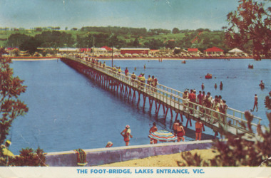
Photograph - Cunninghame Arm footbridge Lakes Entrance Victoria. c1955, Rose Series, 1955 c
Cunninghame Arm footbridge showing crowd on bridge, cars parked on Esplanade, new concrete wall between dunes and lake at south end of bridge Lakes Entrance Victoria. c1955. Also another colour postcard similar view of footbridge made by Murray Views donor Susan Samuel 2 January 2015 number 04272.1, 9 x 14 cmColour postcard taken from south end of the Cunninghame Arm footbridge showing crowd on bridge, cars parked on Esplanade, new concrete wall between dunes and lake at south end of bridge Lakes Entrance Victoria. c1955. Also another colour postcard similar view of footbridge The Foot-Bridge, Lakes Entrance. Vicrecreation, waterfront, land reclamation, gippsland lakes -
 Lakes Entrance Regional Historical Society (operating as Lakes Entrance History Centre & Museum)
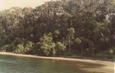
Photograph, M Fish, Kalimna Waterways Gippsland Lakes, 1980 c
taken from Kalimna jetty of Northern Shore of Kalimna Cove showing dense vegetation above rock wall and sandy shore Kalimna Victoria. Second colour photograph shows continuation of scene westward along Reeves Channel Fraser Island visible to South number 04200.1 size 10 x 15 cmColour photograph taken from Kalimna jetty of Northern Shore of Kalimna Cove showing dense vegetation above rock wall and sandy shore Kalimna Victoria. Second colour photograph shows continuation of scene westward along Reeves Channel Fraser Island visible to South number 04200.1 size 10 x 15 cmbridges, waterways, gippsland lakes, topography -
 Lakes Entrance Regional Historical Society (operating as Lakes Entrance History Centre & Museum)
Postcard, Bulmer Collection, Reeves Channel ,Rigby Fraser and Flannigan Islands Lakes Entrance, 1930 c
People in Third photo are Keith and Gladys Scarce 1931Black and white postcard showing Reeves Channel in the Gippsland Lakes between timbered cliffs to the North and Rigby Fraser and Flannigan Islands to the South, taken from Jemmys Point Lakes Entrance Victoria. Also a similar view taken from Kalimna . Third photo of people near the lookout tree Jemmy's Point Lakes Entrancegippsland lakes, jemmys point lakes entrance