Showing 1059 items
matching south melbourne city
-
 Ballarat Tramway Museum
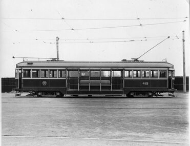
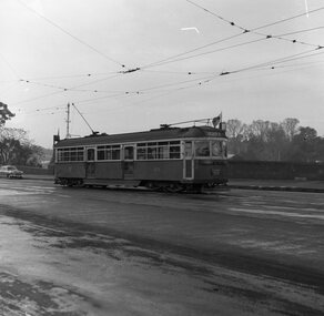
Photograph - Black & White Photograph/s, Sutcliffe Pty Ltd, 1926
Black and white photograph of W1 419 photographed side on at South Melbourne Depot - 1926c. Photographed by Sutcliffe Pty Ltd. Assumed photograph taken soon after the tram was built in 1926. Has "Sutcliffe Pty. Ltd. Photographers Cromwell buildings 366a Bourke St. Melbourne" stamp in purple on back of photo. See Destination City, 4th Edition.On rear in pencil "W1 we have 30 of these. No more will be constructed." "M&MTB" and "41".trams, tramways, mmtb, w1 class, tram 419 -
 Ballarat Tramway Museum
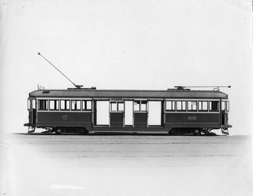
Photograph - Black & White Photograph/s, Sutcliffe Pty Ltd, c1928
Black and white photograph of the side on exterior of W2 506 c1928 (Built by James Moore 1928) Would appear to have been service for as it is fitted with notices in the windows. Taken by Sutcliffe Pty Ltd. Photographers. Background has been faded or painted out. Tram has doors and windshields to driver's cabins. Has "Sutcliffe Pty. Ltd. Photographers Cromwell buildings 366a Bourke St. Melbourne" stamp in purple on back of photo. Destination City, 4th EditionOn rear in pencil "W2 Melbourne", "M&MTB" and "39".trams, tramways, mmtb, w2 class, tram 506 -
 Ballarat Tramway Museum
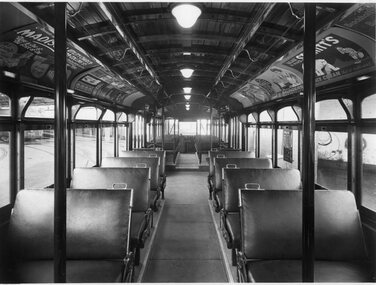
Photograph - Y1 class tram interior, Sutcliffe Pty Ltd, early 1930's
Black and white photograph of the interior a Y1 class tram car, photographed at Camberwell Depot. Shows arrangements of seats, lights with covers and roof ads. A number of roof ads and window posters in the tram - of tram in service. Part of tram 550 in background. On rear is Sutcliffe stamp, and Gordon and Gotch stamp with date July 10. Has "Sutcliffe Pty. Ltd. Photographers Cromwell buildings 366a Bourke St. Melbourne" stamp in purple on back of photo. Destination City, 4th Edition and 5th edition.Yields information about the interior of a Y1 class tramcar.Black and white photograph with details on rear.On rear in pencil is "Return to F. Shennen" with arrow pointing to Gordon and Gotch stamp. "Interior Y1". The Sutcliffe stamp has two pencil crosses through it.trams, tramways, mmtb, y1 class, interiors -
 Ballarat Tramway Museum
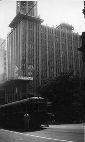
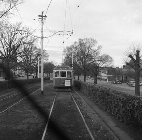
Photograph - Black & White Photograph/s, HSN, 20/11/1932 12:00:00 AM
Black and white photograph of a westbound W2 in Collins St. Melbourne at the intersection with Swanston St with the Manchester Unity building in the background and parts of the Melbourne Town Hall alongside. The Manchester Unity building is under construction with the towers being completed. Tram showing destination of "CITY" and has a person standing alongside - see inscriptions.In pencil on the rear - "The escalator building / Ken standing in front of the tram / HSN / 20/11/32"trams, tramways, collins st, swanston st, manchester unity, melbourne -
 Ballarat Tramway Museum
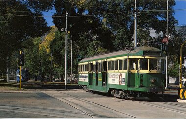
Photograph - Colour Photocopy/photocopies, John Phillips, 28/01/1980 12:00:00 AM
Yields information about the operation of a Ballarat (ex Melbourne) tram in Melbourne during an Australia Day celebrations by the BTPS and the city skyline at the time.Colour photograph of BTM Ballarat Tram No. 40 at the corner of Swanston St and Flinders St. Melbourne on 28 Jan. 1980. Tram fitted with Pioneer Settlement and Peters Ice Cream Roof Ads, showing Sebastopol destination. Taken during the Australia Day celebrations. Young & Jackson Hotel in the background with many advertisements. Photo taken from the Princes Bridge Station Plaza. Taken by John Phillips. Second copy added 9/11/2005 to display box D2. See also Reg Item 4131 and 4132 for other photos of the day - Wellington Parade. See 1979-1980 Annual Reportaustralia day, melbourne, btps, tram 40 -
 Ballarat Tramway Museum
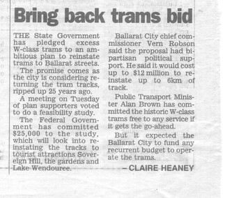
Newspaper, Herald Sun, "Bring back trams bid", 25/01/1996 12:00:00 AM
Item in the Melbourne Herald Sun newspaper, 25/1/1996 that the State Government had pledged excess W class trams to a planned Ballarat Tramway. Reports on the public meeting on the previous Tuesday, comments on proposals. Notes comments by Vern Robson, Chief Commissioner City of Ballarat, Public Transport Minister Alan Brown. Written by Claire Heaney. Has the newspaper details and date taped alongside item.trams, tramways, feasibility study, w-class trams, ballarat city tramway, ballarat revival -
 Ballarat Tramway Museum
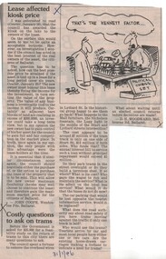
Newspaper, The Courier Ballarat, "Costly questions to ask on trams", 31/01/1996 12:00:00 AM
Letter to the Editor of The Courier, 31/1/1996 written by D.H. Woodward, Melbourne Road, Ballarat questioning the costs for returning trams to Ballarat, traffic problems, safety, use, depot, overhead wires and note that any decision should wait until an elected council returns. Cutting also contains a letter regarding the sale of the kiosk (View Point) and a Burns cartoon, about the "The Kennett Factor". See also items 1467 and 1469."31/1/96" in blue ink on the bottom edge and three "X" marks in black ink.trams, tramways, letter to the editor, ballarat city tramway, ballarat revival -
 Ballarat Tramway Museum
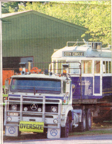
Newspaper, The Courier Ballarat, "Tram carries Ballarat message to City Circle", 24/02/1996 12:00:00 AM
Article from the front page of The Courier, Saturday 24/2//1996 written by Ian Haberfield with photo by Herman Ruyg of BTM W4 671 leaving the depot loaded on a truck the previous day end route to Melbourne to run on the city Circle tram route. Tram has "City Circle" showing in destination box. Notes comments by Peter Hiscock about the tram itself, the BTM works, and that Alan Brown, Public Transport Minister has granted permission for the tram to run on the City Circle.trams, tramways, btm, city circle, ballarat city tramway, ballarat revival -
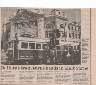 Ballarat Tramway Museum
Newspaper, The Courier Ballarat, "Ballarat tram turns heads in Melbourne", 8/03/1996 12:00:00 AM
Newspaper clipping from The Courier, Ballarat, Friday 8 March, 1996 with story and picture by Alison Wynd of BTM Tram 671 running in Melbourne on the City Circle tram route. Has Flinders St. station in the background. Tram is leaving the safety zone at corner of Flinders and Swanston, eastbound in Flinders St. Quotes Warren Doubleday. 1494..1 - actual clipping 1494.2 - photocopy of the page from the Ballarat Courier - was on page 3.trams, tramways, btm, melbourne, city circle, city of ballarat -
 Ballarat Tramway Museum
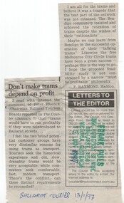
Newspaper, F. Raymond Haddon, "Don't make trams depend on profit", 13/01/1997 12:00:00 AM
Letter to the Editor of The Courier, Ballarat 13/1/1997 by F.Raymond of Haddon commenting on Peter Hiscock's statement of 7/1/1997 and the proposed feasibility study is not constrained by a narrow 'must be profitable' philosophy. Notes the success of Bendigo and the Melbourne City Circle tram route. Cutting has been glued together reducing the item from three columns to two by gluing heading and first three lines on top of the rest of the cutting."Ballarat Courier 13/1/97" in blue ink on bottom of cutting and stamped - "Frank Puls, 164 Humffray St. Nth, Ballarat 3350, Victoria, Australia, 13 Jan. 1997" in green and blue ink.feasibility study, ballarat city tramway, ballarat revival, letter to the editor -
 Ballarat Tramway Museum
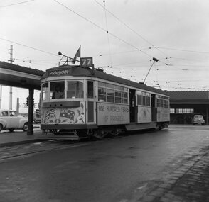
Magazine, Australian Electric Traction Association (AETA), "Electric Traction", Oct. 1971
October 1971 issue of Electric Traction, Vol XXVI No. 10 - featuring Ballarat No. 13 and Davis Bus Lines new bus, both showing destination of Victoria St. on front cover. Note the bus destination uses "Victoria 7" , while the tram has "Victoria St." Sixteen pages, orange banner on front cover. Articles feature closure of Ballarat, Lightweight Electric Intra-City Transit systems and in Search of Gold (Gold minifying traction railways) by A.L Be Bee. On page 8 is an article written by K.S.Kings on the closure of Ballarat, giving details of last services, trams operated, and dates. Features two photos, No. 40 approaching the depot on the final run, 19/9/1971, photo of last tram from Sebastopol at Rubicon St., photo of No. 36 operating in Melbourne during tourism week. Details of this are given in Melbourne news on page 2. See images for these photos. See magazine for photographer details etc.trams, tramways, closure, ballarat, melbourne -
 Ballarat Tramway Museum
Negative, Geoff Grant, 6/07/1954 12:00:00 AM
Negative No. 280 and colour print made by colour laser printer (stored in folder ) of W2 496 in bound along St. Kilda road, outside Victoria Barracks, 6/7/1954. Tram has destination of "CITY". Photo by Geoff Grant. Hi res scan of negative and image updated 19/5/2020.trams, tramways, melbourne, st kilda road, victoria barracks, tram 496 -
 Ballarat Tramway Museum
Negative, Geoff Grant, 7/05/1955 12:00:00 AM
Negative No. 282 and colour print made by colour laser printer (stored in folder ) of SW6 914 approaching the Batman Avenue terminus 7/5/1955. Photo by Geoff Grant. Tram has dash canopy lighting, with three holes that were cut in pending conversion to standard headlight arrangements - see Destination City (4th Edition page 52) for notes regarding headlights. Hi res scan of negative and image updated 19/5/2020.trams, tramways, melbourne, batman ave, dash canopy lights, headlights, tram 914 -
 Ballarat Tramway Museum
Negative, Geoff Grant, 7/05/1955 12:00:00 AM
Negative No. 287 and colour print made by colour laser printer (stored in folder ) of SW6 961decorated for the centenary of the City of Prahran at Batman Avenue terminus on 7/5/1955. Photo by Geoff Grant. Showing destination of Prahran and route 77. Has three holes cut in the dash canopy lighting shield. Reference page 52 of Destination City 4th Edition. Hi res scan of negative and image updated 19/5/2020. See Destination City 4th Edition. page 52.trams, tramways, melbourne, batman ave, city of prahran, decorated trams, tram 961 -
 Ballarat Tramway Museum
Negative, Geoff Grant, 16/06/1955 12:00:00 AM
Negatives No. N301 and colour print made by colour laser printer (stored in folder ) of a Bourke St Bus stopped at Exhibition St. stop, looking east along Bourke on 16/6/1955. Photo by Geoff Grant. Has the Melbourne Hotel, the Salvation Army City Temple and the J & J Building (Mickey Powell Dancing). Parliament House in the background. Negative scanned hi res and imaged updated 20/5/2020.trams, tramways, melbourne, bourke st., buses, exhibition st. -
 Ballarat Tramway Museum
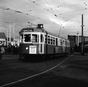
Negative, Geoff Grant, 25/06/1955 12:00:00 AM
Negative No. N351 and black and white print made by a laser printer (stored in folder ) of tram W7 1001 on AETA tour (Australian Electric Traction Association) on 25/6/1955 entering shed roads at the then new East Preston depot. Tram has AETA tour signs and the slogan "Electric Transport a Necessity - Protects your investment, builds your city, creates business". In route number box is letter "B". Negative scanned hi res and imaged updated 22/5/2020. trams, tramways, melbourne, preston depot, aeta tour, tram w7 1001 -
 Ballarat Tramway Museum
Negative - Set of 2, Geoff Grant, 25/06/1955 12:00:00 AM
Negatives No. N352 and N353 and black and white prints made by a laser printer (stored in folder ) of tram SW6's 888 travelling to Preston Depot on AETA tour (Australian Electric Traction Association) on 25/6/1955. Tram has AETA tour signs and the slogan "Electric Transport a Necessity - Protects your investment, builds your city, creates business". In route number box is letter "B". Geoff Grant's envelope notes the photos as being taken from the cabin of SW6 887. 1615.1 - In Victoria Parade - note hedges 1615.2 - in Victoria St., North Richmond, just to the west of the railway overbridge. Negative scanned hi res and imaged updated 22/5/2020.trams, tramways, melbourne, victoria st, victoria parade, aeta tour, tram sw6 888 -
 Ballarat Tramway Museum
Postcard, Mary Jayne's Railroad Specialities Inc, Melbourne W2 456
Colour postcard of Melbourne W2 456 inbound to the City on route 31 at the intersection of Brunswick St and Victoria Parade c1986. Tram has advertisements for the ABC News and another company. On rear of photograph are details of the postcard, photographer (Raymond J. Marsh), stamp location with two card numbers and a copyright note "Mary Jayne's Railroad Specialities, Inc." Not known when actual postcard was produced.trams, tramways, melbourne, victoria parade, tram 27, tram 38 -
 Ballarat Tramway Museum
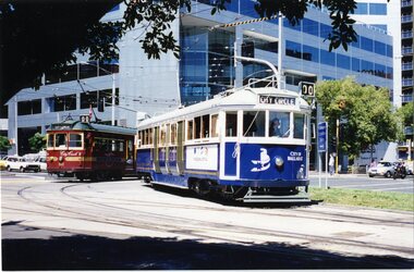
Photograph - Colour Photograph/s, William. F. Scott, 5/03/1996 12:00:00 AM
Photo of 'City of Ballarat' no. 671 turning from Nicholson St. into Victoria Parade while running the City Circle route on 5-3-1996. City circle tram No. 842 in background.On rear, stamped on 'William F.Scott, 5.3.1996, 9' and a green label with '2'671, city circle, melbourne, victoria parade, nicholson st, tram 671, tram 842 -
 Ballarat Tramway Museum
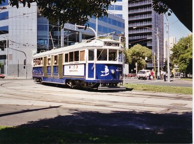
Photograph - Colour Photograph/s set of two, William. F. Scott, 5/03/1996 12:00:00 AM
Photo of 'City of Ballarat' tram No. 671 turning from Nicholson St. into Victoria Parade while running the City Circle service on 5.3.1996. See also item 463. Was used in the May 1996 issue of Trolley Wire, p24. 464.1 - additional two copies added 15.6.2009, from William F Scott. Larger prints of photograph (2) shifted to A4 AS Box 51.On rear, stamped on 'William F. Scott, 5.3.1996, 4', 'photo page 24, same size, with cropping markings and a green dot with '1' in top corner. 464.1 - both copies "Ballarat Tramway Museum / William F Scott Photo", "ex Melbourne W4 series car 671 on the Melbourne city circle 5.3.1996. The car carries the colours of the Ballarat City Council".city circle, 671, melbourne, victoria parade, nicholson st, tram 671 -
 Ballarat Tramway Museum
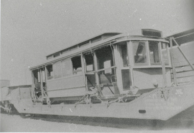
Photograph - Black & White Photograph/s, George Netherway, 1930
Copy photograph of a small photograph contained within item Reg. No. 587. Photograph is of an M class tram ex Melbourne, sitting on a railway truck within Ballarat Railway yards, prior to unloading. Caption on 587 says "Melbourne No. 112 arrives at Ballarat Railway Stn". However Kings,"The Ballarat Tramways" and "Destination City", say No. 112 did not come to Ballarat. Kings p36 gives dates as May or June 1930. Hi Res scan added 25/3/2011trams, tramways, ballarat, new trams, m class, railway station -
 Ballarat Tramway Museum
Photograph - Colour Photograph/s, Travis Jeffrey, 21/08/1971 12:00:00 AM
Colour photograph of Ballarat No. 27 at the Victoria St. terminus, prior to returning to the City with passengers boarding the tram. Shows end of double lane highway from Melbourne. Tram has destination Gardens via Drummond Nth and SEC roof advertisement "Everything's under control in my all electric kitchen". Photo on Agfa Paper and taken on Friday 21 August 1971.Stamps with faded green ink: "Photo by Chris Jeffrey / Number" with number "104PC/18" in blue ink and date stamp "Friday 21 August 1971" also in faded green ink.victoria st, tram 27 -
 Ballarat Tramway Museum
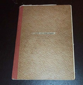
Book, H.P. James, "Out of the Past", 1940
ESCo Employee Hours Work Record book that has been used by an ESCo/SEC inspector, H. P. James as a record / note book for his personal collection or papers or journal titled "Out of the Past". Book sewn with string in 36 page sections, blank end papers, board covers with stipple paper out sides and Rexene cloth binding. Comprising plain paper end papers and 104 printed pages (52 leaves), with each sheet printed in black on feint ruled paper for recording the hours worked and other details of drivers and conductors employed by ESCo. Printed for daily use, with Day and date page headings - made out for the 1930's. Images: Book - i1 Inside front cover - i2 Members Certificate - i3 Has been used to gather mementos such as photos, articles, newspaper clippings, letters and other miscellaneous documents on Ballarat local history. Newspaper cuttings etc often have side notes written by Mr. James. Inside front cover has certificate recording Mr. James membership to the Ballarat Historical Society for 1940. Receipt signed by Edward Crimmins. Also a newspaper cutting on the cost of pensions to Lord Nelson's family. On facing page a photo of Queen Elizabeth, a printer colour cover or sheet about Walt Disney's "Pinocchio", a newspaper cutting regarding Father's Day and a black and white photograph of a young girl in a hospital carriage being pushed by a man. Pages numbered odd numbers only in the top right hand corner in pencil. Primary items are: 1 - Coloured cover to a writing tablet, titled "Australian Birds". Underlying this on the back of the writing tablet is two newspaper cuttings: the Ballarat Historical Society - reports on the 6th Annual meeting of the Society. 3 - Photo of the pattern Ballaarat Horse Tram company tram outside the Duncan and Fraser's Carriage Works in Adelaide with hand written notes underneath, including a sketch of a horse tram drivers seat - see Reg. Item 2527. 4, 6 - Group of nine black and white printed cards (15 illustrations) of early Ballarat pasted onto the sheet - see Reg. Item 2528. 5, 7 & 9 - Printed notes titled "Valedictory to Bob Haines" - see Reg. Item 2529. On page 9 in the left hand margin, a printed list of Church Officers; Church of England. 8 - Newspaper cuttings titled "The Heralds Man's Quiz" and the answers adjacent. City of Ballaarat - Public Inoculation Depot - Influenza form for HP James of ESCo - See Reg. Item 2530. Page Numbering from this point changes - even numbers in top right hand corner of folios instead of odd numbers. 9A - Newspaper cuttings about a Theatre Show, 54 years service of Mr. E. R. Bodycomb (Ballarat Gas) and planting of trees in the Avenue of Honour - with a red line around H. P. James names and a reproduction of the opening photograph of ESCo Electric Trams - noting 30 years ago - See Reg. Item 310.2. ESCo 4d Ticket - Purple - Grenville St to Sebastopol Terminus - See Reg Item 2531. ESCo 3d Adult Transfer Ticket - See Reg. Item 2532. Illustration - cartoon - H.P. James - See Reg. Item 2533. 10 - Newspaper cutting "From Horse Tram to Trolley Bus" - See Reg Item 2534. Newspaper cutting "Melbourne's First Tramcars" - See Reg Item 2535. An inscription or written note from T. Thomas etc. on lower edge of the sheet. 11,12 - Newspaper cuttings about the Passing of Melbourne's Cable Trams, including a photo of cable trailer No. 1 - See Reg. Item 2536. Other cuttings about early residents of the Ballarat district. 13 - Newspaper cutting dated 2/5/1936 about the donation from the CTA to the Ballarat Hospital. 14 - Newspaper cuttings - Photo of Ballarat Bicycle and Tricycle Club in the Gardens, the issue of a stamp to commemorate the Centenary of Ballarat, radio stations in Sydney, Ballarat Choirs and fire brigade demonstrations trophies. 16 - Copy of the "City of Ballaarat Regulation No. 13" concerning Hackney and Stage coaches working within the City - See Reg. item 2537. 18, 20 - Newspaper cutting - "The Working Classes in Early Ballarat" - Nathan Spielvogel 21 - handwritten note on "Doctor" Thomas Blackett who died during 1940. 22 - Miscellaneous cuttings from the Melbourne Sun. 23 - Newspaper cuttings "Story of South Street", Show Grounds, and "The Alfred" Hall and a photograph of the 1938 Floral Carpet at Alfred Hall. 24 - Newspaper cutting - obituary and hand written note on Ballarat identity Mr. J. P. Bourke. 25 - Newspaper cutting - cartoon "Tiddley" Winks and Wally - Stan Cross (later "Wally and the Major" 26 - Newspaper cutting - "Ballarat in the sixties" - General R.E. Williams and "Early Recollections" - Arthur Reid. 27 - Handwritten note re Mrs. Bill Danks, dated Jan. 1941 - Tobacconist in Bridge St. 28 - Newspaper cutting - "First Town Hall" and note on "City Hall". 30 - Newspaper cuttings - "Good Friday, Now and Then - T.P. Long, Mont Albert and "On Fashions" James R. Pound. 32 - Newspaper cutting "School and School life in old Ballarat" - Nathan F. Spielvogel. 34 - Newspaper cutting continued from page 32 and Obituary - Mr. Archie Dawson and Tom Blackett. 35 - Newspaper cutting of Ballarat - 4 photos - include Bridge St. with a tram. 36 - Newspaper cutting - "Ballarat - Pastoral and Industrial Resources" from a Melbourne paper, 17/2/1940. 38 - Newspaper cuttings - obituaries - Mr. R. E. Tunbridge, Graeme Dowling and Thomas Crosthwaite. 39 - Illustration - black and white - Late Mr. P. J. Pringle - See Reg. Item 2538. 40 - Handwritten notes on Ballarat Trams and the power station staff - See Reg. Item 2539. 41 - Handwritten notes on Ballarat Pie Stalls 42 - Newspaper cuttings - cartoon "Professor Nimbus", photo of the Norwegian town of Hell (Railway station); bicycles on a Copenhagen bridge following German occupation and dragon flies in Melbourne. 43 - Newspaper cutting on the official opening of the Ballarat Historical Society's Museum. 44 - Newspaper cuttings and associated handwritten notes on a fire in Ballarat, poultry fanciers, historical dates for August. 46 - Newspaper cuttings - "Victoria's first profitable goldfield" - Ballarat and the unveiling of the Sovereign Hill direction pillar. 48 - Newspaper cutting - "Worked 27 years without holiday" - See Reg. Item. 2540. - Other newspaper cuttings - thoughts of a visitor to Ballarat from Sydney and H.P. James - Liquor control in Ballarat and "This Week at the Zoo". 50 - Handwritten notes on clothing. 51 - Handwritten note on a visit to W. H. Middleton 52 - Newspaper cuttings "The Kings Empire", "Ballarat Birthdays" for Sept and Oct and an obituary on Mr. W. H. Middleton. 54 - Newspaper cuttings "Richmond has Links With Early Goldfields" - Malcolm McCullum and "England's Greatest Battle" 55, 56 - Newspaper cuttings - "Ballarat Birthdays" for November and December, a photograph of Nick Oliver - former Ballarat fireman and "Railway Birthday" - birth of the VR. 57, 58 - Handwritten notes on Ballarat tram timetables, weekly tickets, motorman's record cards, tourist tickets and sample tickets or cards, See Reg. Item 2541. Lunch Hour Weekly Ticket - Reg. Item 2542 Morning and Evening Weekly Ticket - Reg. Item 2543 Motorman's Record - Reg. Item 2544 Tourist Ticket - 1/- - Reg. Item 2545. 60 - Newspaper cuttings - parts 1 and 2 - "The Two Ballarat" by Nathan Spielvogel. 62 - Newspaper cuttings - continued from page 60, the death of comedians Sam Mayo and Gus Bluett and some handwritten notes on comedians. 64 - Newspaper cuttings on cricket, choir rules, a Methodist ladies function at the home of H.P. James, Footballer Percy Beames and entertaining air force recruits at the showgrounds. 66 - Newspaper cuttings - "The Anvil Chorus" - Hitler and Mussolini and "Strength against Nazi Threat". 68 - Newspaper cuttings - 50 years ago in Ballarat, Social function at H.P. James house, coldest morning in Ballarat and the death of Col. A. W. Bennett. 70 - Newspaper cuttings - about the sale of spirits in early Ballarat, the first motorcars in Ballarat and handwritten note about Mr. Jago. 72 - Newspaper cuttings - misc. about horse racing, trainers and racing. 73 - Newspaper cuttings and handwritten notes about Ballarat Schools. 74 - Newspaper cuttings - Bruno Hauptmann (Charles Lindbergh) and the death of actor Darcy Kelway. 75, 76 - Newspaper cuttings - Rail services to and from Ballarat, effects of the war and Ballarat 70 years ago, the invasions of Britain and "A stroll down Memory Lane" - T.P. Long of Mont Albert. 77,78 - Newspaper cuttings - Lake Wendouree - Nathan Spielvogel, the opening of the new Ballarat Historical Society's Museum and farewell function of Mr. James Shannon. 79 - Newspaper cuttings - about boats on lake Wendouree. 99 - Obituary and hand written note re Mr. Arthur M. David. 100 - Newspaper cuttings - cartoon "Wally and the Major", Dr William Maloney, Gus Bluett and "Old Rowley" - in connection with the Melbourne Cup of 1940. 101 - Cartoon advertisement for Kolynos Dental Cream Inside rear cover - Programme for the Centenary of Thanksgiving Service - Back to Ballarat 1934, dated 4/11/1934 (has been affected by other sheets of paper due to their acidic nature), printed notes titled "A ramble on stilts with Freddie" written by Baker James. Many in pencil and inktrams, tramways, h.p. james, esco, horse trams, ballarat, civic history -
 Ballarat Tramway Museum
Newspaper, "Melbourne's First Tramcars", 11/03/1962 12:00:00 AM
Newspaper clipping contained within Reg. Item 2526, page 10, titled "Melbourne's First Tramcars" - noting that the Argus of 11/3/1962 reported that two of Mr. George Francis Train's patent tramcars had been landed in Melbourne with fittings for four more. Item said that promoters were negotiating with the City Council, but these fell through, as Council did not have the power to lease the streets for railway purposes. Has been cut out from a sheet and pasted into the book. Note Item Not formally Numbered.melbourne, tramcars, tramways -
 Ballarat Tramway Museum
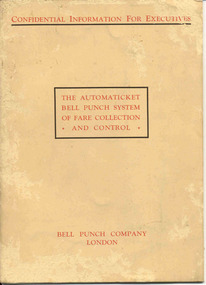
Manual, Bell Punch Co, "The Automaticket Bell Punch System of Fare Collection and Control", c1935
... Issue Machine" or "TIM" tickets - eg City of South Melbourne..." or "TIM" tickets - eg City of South Melbourne library fine ...Yields information about the method that the State Electricity Commission of Vic undertook interviews for staff appointments. Gave advice of the era for such interviews and objectives of the interview.Thirty page book printed on heavy light brown paper, stapled with an folded card cover titled "The Automaticket Bell Punch System of Fare Collection and Control". Describes the Automaticket system, has samples of traffic tickets pasted in the book, diagrams, drawings, gives details of the components and method of operation in particular ticket inspection, ticket and checking back office functions. Published by the Bell Punch Company of London early to mid 1930's? Cover and each page headed "Confidential Information for Executives". Has a photo of South Western Roadlines double deck bus with a conductor. See also Reg. Item 3629 for another version of the pamphlet for this machine. In the rear cover of the book, folded and stapled to give a pocket, are listed three forms that would have been provided with the book - not with the collected copy. -However in the pocket were eleven 11 "Ticket Issue Machine" or "TIM" tickets - eg City of South Melbourne library fine, packing slips, sample meal tickets, Army canteen beer tickets, and sample bus tickets - including one pinned to a business card - John Bolland of Eastern Suburbs Omnibus Service who were the agents for the TIM machines. (image btm3645i3) Card has date of "4-1-50". Also three sample Bell punch tickets and one ultimate machine ticket - two 1d tickets. As well at the time of acquisition were a SEC Special Pass - to Reg Item 3648 and a SEC Staff Pass ticket - to Reg item 3649. Full scan of document added as a pdf file 5/6/2019. trams, tramways, tickets, ticket machines, buses, bell punch -
 Ballarat Tramway Museum
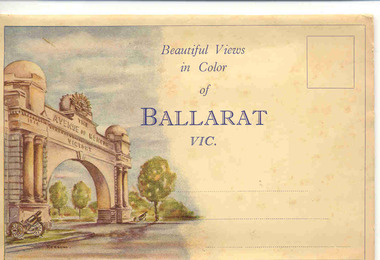
Postcard - Folder set, Valentine & Sons Publishing Co, "Beautiful Views in Color of Ballarat Vic", Early 1950's
Shows views of Ballarat city, tourist attractions, Lake Wendouree in the 1950's, with some distance views of the trams in the streets. Demonstrates production of souvenirs of the era - folded postcards.Set of 9 coloured views of Ballarat printed with all photos on one side of a folded strip of paper glued within an colour printed light card folder. Published by The Valentine Publishing Co. Pty Ltd of Melbourne and Sydney., titled "Beautiful Views in Color of Ballarat Vic". Front cover has a image of the Arch of Victory on the left hand side with space for title, address area and stamp. Rear of Cover has printer name and a slit for the envelope to be closed over and sealed. 1. The Avenue of Honor and the Arch of Victory 2. The Eureka Stockade Memorial 3. The Old Curiosity shop 4. Town Hall Sturt St. (with trams in distance views, note Myers verandah still there) 5. Sturt St showing Mt. Warrenheip in the distance 6. Picturesque scene in the Gardens 7. The Boat shed and basin, Lake Wendouree 8. Sturt St. (from Greville St and large Robur Tea advertisement on building) 9. The Conservatory in the Gardens. From the motor vehicles in the photograph would say early 1950's. trams, tramways, ballarat, postcards, sturt st, bridge st, gardens, grenville st, lake wendouree -
 Ballarat Tramway Museum
Photograph - Black & White Photograph/s, Sep. 1888
Yields information about the trails of an alternative method of propulsion of tramcars - electric battery. Shows the vehicle while on trial in Melbourne. Shows the people involved in the trials.Black and White copy photograph of a State Library of South Australia SLSA B34583, of the Julien battery-electric tramcar on trials in Toorak Road, Melbourne; see page 27 of The Golden City and its Tramways and for the photo itself. Trails undertaken September 1888. Collected by Alan Bradley from the State Library of South Australia early 1980's. For details of the Adelaide trials - see https://commons.wikimedia.org/wiki/File:Julien%27s_Patent_battery_tram,_Henley_Beach,_9_January_1889_(SLSA_B-5468).jpg (accessed 22/8/2020). And the Oct. 1977 issue of Trolley Wire, for the construction, testing and disappearance of the tram. 3791.1 - 2nd print obtained by William F Scott on light weight paper - 2 copies2785.1 - on rear of both copies in ink "Trial run of battery electric car in South Yarra (Melbourne) on cable car tracks. 1888. The same car ran in Ballaarat shortly there after." In pencil "Photograph courtesy of the State Library of South Australia SLSA B 34583"tramways, trams, duncan fraser, battery trams, julien system, melbourne -
 Ballarat Tramway Museum
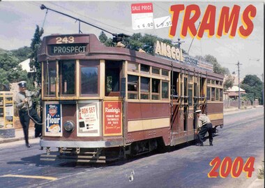
Document - Calendar, Topmill Pty Ltd, "Trams 2004 Calendar", 2003
26 Page full colour calendar with heavy card covers featuring Australian Trams, published by Topmill Pty Ltd. Cover (2983i1) features Adelaide No. 243 at Mitcham. Other cities represented - Brisbane, Sydney, Adelaide, Perth, Fremantle, Bendigo, Ballarat, Rockhampton, Sydney, and Melbourne. Photos by Arthur Perry, Ken Smith, Lawrie Hort, Leonard Stewart and Les Horsburgh. Originally priced at $9.95, and has Sale Price with $6.00 sticker. Distributed by Gordon and Gotch. Ballarat trams- 2983i2 - 26 southbound in Albert St to Sebastopol in 1970 used for month of May. Has been used at the depot to marked charters for each month and visitors and reminder dates. tramways, trams, australian trams, ballarat, bendigo, museums -
 Ballarat Tramway Museum
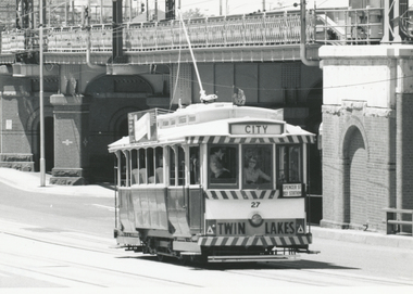
Photograph - Black & White Photograph/s, John Phillips, 26/01/1981 12:00:00 AM
Yields information about one of the two visits to Melbourne for the Australia Day Parade of one of the Museum's trams.Black and White photograph of BTM No.27 operating in Flinders St. near intersection with William St. Melbourne during Australia Day 1981 - 26/1/1981 - see March 1981 issue of Fares Please!. Carolyn Dean driver. Photo John Phillips. Tram has destination of "CITY" and an auxiliary board "Spencer St Rly Station" and Twin Lakes sign. In the background is the Flinders St. railway bridge. Two copies held. See Reg Item 7402 for another photo of the tram in Flinders St. tramways, trams, btps, flinders st, australia day, tram 27 -
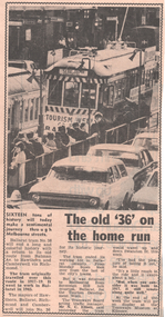 Ballarat Tramway Museum
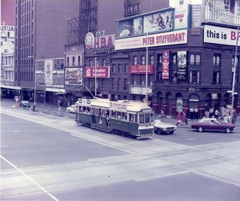
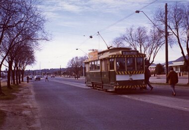
Newspaper, Herald Sun, "The old '36' on the home run", Sep. 1971
Newspaper clipping from The Melbourne Sun, 22/9/1971, about the operation of Ballarat No. 36 promoting the City of Ballarat, during Tourism Week. Notes that it will be running in Swanston St. during the week. Quotes Mr. N.C. Elliott of the MMTB, acting Traffic Manager about the tram. Includes a photo of the tram at a Swanston St. stop. (probably Flinders St.). Notes its running to Hawthorn and the relevant Mayors travelling on the tram. See also Reg. Item 3432.On rear in ink "Sun Wed Sept 22, 1971"melbourne, tourism, mmtb, swanston st, hawthorn