Showing 922 items matching "stone building"
-
 Unions Ballarat
Photographs: Unions Ballarat building renovations 2018, 2018
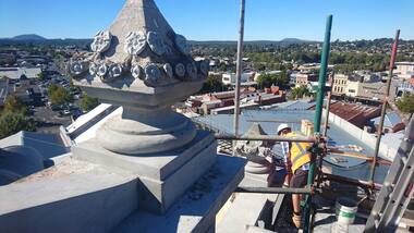
The Ballarat Trades Hall building is located at 24 Camp Street, Ballarat. The foundation stone was laid in October 1887. (Architects were Messrs James and Piper and builders were Messrs Lietch and Outtrim.) Over several decades, the façade of the building has fallen into disrepair and was posing a safety risk. Thanks to Victorian heritage grants and ongoing public donations, refurbishment of the façade is currently underway by Troon Pty Ltd. The photos in this entry show the deterioration of the building and the progress in restoring it to its former state. Progress catalogued by date: 13 February 2018 - 1 photo 19 February 2018 - 1 photo 23 February 2018 - 1-6 photos 5 March 2018 - 1-5 photos 12 March - 1 photo 4 April 2018 - 1-6 photos 18 April 2018 - 1-7 photos 23 April 2018 - 1 photo. The top of our restored building starts to poke out as the scaffold comes down level by level - the rendered wash-coat colour looks fantastic in the sun - as close as we can get to the original 1887 colour.The Hall is a community hub in Ballarat as well as being the point of contact and activism for unions and unionists in the area. These photographs are a critical part of the building's history.Photographs of Ballarat Trades Hall renovations. btlc, ballarat regional trades and labour council, ballarat trades hall, building, building fund, james and piper, lietch and outtrim, troon pty ltd, building - resoration, heritage victoria, grants -
 Unions Ballarat
Photograph - Photographs: New Flag Poles - Trades Hall - 2018, 26 April 2018
The Ballarat Trades Hall building was erected in 1887 - the foundation stone being laid on 15 October of that year. The photographs show new flag poles that were installed to the building on 26 October 2018. Flags shown in the photos are the Red Flag and the Flag of the Southern Cross. Scaffolding was erected to undertake restoration of the building façade. Significant to the character of the Ballarat Trades Hall building.Electronic photographs - jpeg.ballarat trades hall, ballarat regional trades and labour council, btlc, flags - red, flags - southern cross, flags - btlc, building works -
 Ballarat Heritage Services
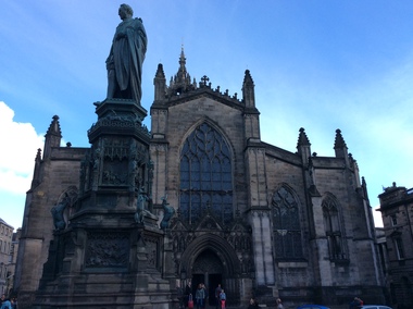
Digital Photograph, St Giles Cathedral, Edinburgh, Scotland, 10/2016
St Giles, also known as the High Kirk of Edinburgh is the principal place of worship for the Church of Scotland. It is very interesting for the mason's marks found on its many stone columns inside the church, and for its connections to the graveyard outside. According to wikipedia, "There is record evidence of a church here, very likely on the present site, in the year 854. In 1120 King Alexander I, rebuilt the church in the Norman style. Of this building characteristic features survived until 1798. During the fourteenth century, Edinburgh was captured and plundered by the English under Edward II. and Edward III., and twice St Giles was laid waste. After restoration, the church was more thoroughly ruined at the Burnt Candlemas in 1387, when Richard II. sacked the city. The western part of the fabric was soon in use again ; but the restoration of the choir and transepts, which were much enlarged, lasted on into the sixteenth century. In 1467 the city endowed St Giles as a collegiate church. It now became usual to speak of the nave, where the stonework was ancient, as the Old Kirk, while the eastern part of the building was called the New Kirk. When the movement for reform drew large crowds to St Giles, separate services began to be regularly held in the Old and New Kirks. Soon this was not enough, and the great church was partitioned off into smaller sections. In 1571 St Giles was seized by Kirkcaldie of Grange, and held by him as a stronghold for Queen Mary. This resulted in serious damage to the structure.Colour photograph of St Giles Cathedral, Edinburgh, Scotlandst giles cathedral, edinburgh, scotland, architecture -
 Ballarat Heritage Services
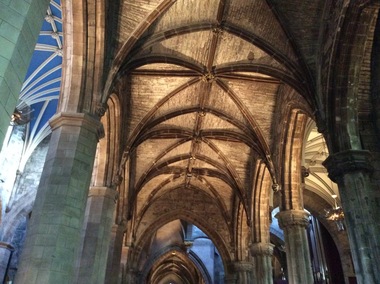
Digital Photograph, Dorothy Wickham, Interior, St Giles Cathedral, Edinburgh, Scotland, 10/2016
St Giles, also known as the High Kirk of Edinburgh is the principal place of worship for the Church of Scotland. It is very interesting for the mason's marks found on its many stone columns inside the church, and for its connections to the graveyard outside. According to wikipedia, "There is record evidence of a church here, very likely on the present site, in the year 854. In 1120 King Alexander I, rebuilt the church in the Norman style. Of this building characteristic features survived until 1798. During the fourteenth century, Edinburgh was captured and plundered by the English under Edward II. and Edward III., and twice St Giles was laid waste. After restoration, the church was more thoroughly ruined at the Burnt Candlemas in 1387, when Richard II. sacked the city. The western part of the fabric was soon in use again ; but the restoration of the choir and transepts, which were much enlarged, lasted on into the sixteenth century. In 1467 the city endowed St Giles as a collegiate church. It now became usual to speak of the nave, where the stonework was ancient, as the Old Kirk, while the eastern part of the building was called the New Kirk. When the movement for reform drew large crowds to St Giles, separate services began to be regularly held in the Old and New Kirks. Soon this was not enough, and the great church was partitioned off into smaller sections. In 1571 St Giles was seized by Kirkcaldie of Grange, and held by him as a stronghold for Queen Mary. This resulted in serious damage to the structure.Two colour photographs of the interior if St Giles Cathedral, Edinburgh, Scotlandst giles cathedral, architecture, mason's marks, stonemasons, church of scotland -
 Ballarat Heritage Services
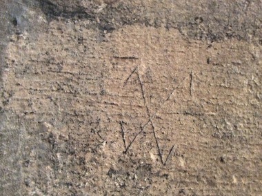
Digital Photograph, Stonemason's marks, St Giles Cathedral, Edinburgh, Scotland, 10/2016
St Giles, also known as the High Kirk of Edinburgh is the principal place of worship for the Church of Scotland. It is very interesting for the mason's marks found on its many stone columns inside the church, and for its connections to the graveyard outside. According to wikipedia, "There is record evidence of a church here, very likely on the present site, in the year 854. In 1120 King Alexander I, rebuilt the church in the Norman style. Of this building characteristic features survived until 1798. During the fourteenth century, Edinburgh was captured and plundered by the English under Edward II. and Edward III., and twice St Giles was laid waste. After restoration, the church was more thoroughly ruined at the Burnt Candlemas in 1387, when Richard II. sacked the city. The western part of the fabric was soon in use again ; but the restoration of the choir and transepts, which were much enlarged, lasted on into the sixteenth century. In 1467 the city endowed St Giles as a collegiate church. It now became usual to speak of the nave, where the stonework was ancient, as the Old Kirk, while the eastern part of the building was called the New Kirk. When the movement for reform drew large crowds to St Giles, separate services began to be regularly held in the Old and New Kirks. Soon this was not enough, and the great church was partitioned off into smaller sections. In 1571 St Giles was seized by Kirkcaldie of Grange, and held by him as a stronghold for Queen Mary. This resulted in serious damage to the structure.Colour photographs of tonemason's marks, St Giles Cathedral, Edinburgh, Scotlandmason's marks, st giles cathedral -
 Ballarat Heritage Services
Photograph - Digital Photograph, Stonemason's marks, St Giles Cathedral, Edinburgh, Scotland, 10/2016
St Giles, also known as the High Kirk of Edinburgh is the principal place of worship for the Church of Scotland. It is very interesting for the mason's marks found on its many stone columns inside the church, and for its connections to the graveyard outside. According to wikipedia, "There is record evidence of a church here, very likely on the present site, in the year 854. In 1120 King Alexander I, rebuilt the church in the Norman style. Of this building characteristic features survived until 1798. During the fourteenth century, Edinburgh was captured and plundered by the English under Edward II. and Edward III., and twice St Giles was laid waste. After restoration, the church was more thoroughly ruined at the Burnt Candlemas in 1387, when Richard II. sacked the city. The western part of the fabric was soon in use again ; but the restoration of the choir and transepts, which were much enlarged, lasted on into the sixteenth century. In 1467 the city endowed St Giles as a collegiate church. It now became usual to speak of the nave, where the stonework was ancient, as the Old Kirk, while the eastern part of the building was called the New Kirk. When the movement for reform drew large crowds to St Giles, separate services began to be regularly held in the Old and New Kirks. Soon this was not enough, and the great church was partitioned off into smaller sections. In 1571 St Giles was seized by Kirkcaldie of Grange, and held by him as a stronghold for Queen Mary. This resulted in serious damage to the structure.Three photographs of stonemason's marks, St Giles Cathedral, Edinburgh, Scotlandmason's marks, st giles cathedral -
 Ballarat Heritage Services
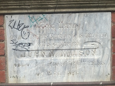
Photograph - Photograph - Colour, Clare Gervasoni, YMCA Ballalrat, 2016, 30/07/2016
... Three photographs relating to the YMCA Ballarat building... to the YMCA Ballarat building, including the Foundation stone. YMCA ...At one time pre-service teachers' of the Ballarat Teachers' College boarded at the YMCA. There also used to be an inside pool at the site. Three photographs relating to the YMCA Ballarat building, including the Foundation stone. The land on which this building is erected was given by John W. Wilson one of the pioneer citizens of Ballaratymca, young mens christian association, foundation stone, camp street, ballarat, john w. wilson -
 Ballarat Heritage Services
Photograph - Photograph - Colour, Former Lake Condah Aboriginal Mission, 17/04/2016
The Lake Condah Mission site includes bluestone ruins and a reconstructed timber building, as well as the cemetery which were part of the original settlement. With European settlement in the 1830s came conflict. Gunditjmara people fought for their land during the Eumerella wars, which lasted more than 20 years. As this conflict drew to an end in the 1860s, many Aboriginal people were displaced and the Victorian government began to develop reserves to house them. Many Aboriginal people refused to move from their ancestral land and eventually the government agreed to build a mission at Lake Condah, close to some of the eel traps and within sight of Budj Bim (Mt Eccles). The mission opened in 1867. The Mission was formally closed in 1918, and Aboriginal people were forced off the Mission, some moving to Lake Tyers. The Gunditjmara protested against the Mission’s closure and many continued to reside in the buildings until the majority of the reserve land was handed over to the Soldier Settlement Scheme in the 1940s. The mission was destroyed by the government in the 1950s in an effort to force the integration of Gunditjmara people with the general community but the Gunditjmara people continued to live in the area and protect their heritage. The mission lands were returned to the Gunditjmara in 1987. Lake Condah Mission is a place with special meaning to the Gunditjmara community - as a community meeting place, an administrative centre, a symbol of political struggle and a link to family histories. As a result the Gunditjmara community do not want open public access to this site. Key Features of Interest Ruins of stone cottages and plot remains of buildings such as the church Reconstructed dormitory building (https://www.budjbim.com.au/visit/cultural-sites/lake-condah-mission/?gclid=EAIaIQobChMIz6j36ZvF-QIV8ZhmAh2tmA3qEAAYASAAEgLxrvD_BwE, accessed 2022)Colour photographs of the former Lake Condah Aboriginal Missionlake condah, lake condah aboriginal mission, aborigines, aboriginal, gunditjmara, eumerella wars -
 Ballarat Heritage Services
Photograph - Photograph - Colour, Clare Gervasoni, Former School at Weatherboard, Victoria, c2010
Weatherboard is a small town in Western Victoria.Anecdotally the name is thought to have originated because it was the first place in the region to have a home built using weatherboard rather than corrugated iron, stone or bricks. It is in the boundaries of the City of Ballarat. The School, Number 656, was opened on 01 August 1862 and closed on 04 February 1948. it was also known as Weatherboard Hill Common School and Weatherboard Hill State School.The bluestone school building had a slate roofand its first head teacher was James Richmond..In 1915 Health Officer, Dr Willis, strongly condemned the old bluestone building as being damp and unsanitary. in 1948 enrolments dropped to 6 and the school closed. The Weatherboard State School World War One Honour Board is located at Burrumbeet Hall. An early bluestone school known as the Weatherboard School.weatherboard school, former weatherboard school, education, weatherboard hill common school, weatherboard hill state school -
 City of Ballarat Libraries
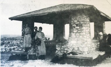
Photograph - Card Box Photographs, Black Hill Lookout, Ballarat 1924
People sit under stone shelter at the Black Hill Lookout.black hill lookout, building, people, public -
 City of Ballarat Libraries
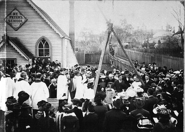
Photograph - Card Box Photographs, Laying the Foundation Stone of St Peters Church Hall, Ballarat circa 1900
st peter's church, building, persons, public -
 Loreto Australia and South-East Asia
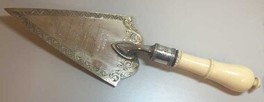
Commemorative Trowel, Joseph Sleep, c.1881
Presented to the Bishop of Ballarat, Dr. James Moore, when he laid the foundation stone for the new schoolroom/residential wing at Loreto Mary's Mount. A decorative artefact manufactured by an early Ballarat jeweller. Records the early building and expansion of Mary's Mount.Silver engraved commemorative trowel with ivory handle.Presented by the Architect to The Very Rev'd J. Moore D.D.V.G. on the occasion of his laying the foundation stone fo the Loretto Convent Ballarat 8th Dec'r 1881 -
 Whitehorse Historical Society Inc.
Photograph, Vitclay Pipes Pty Ltd, 1995
First owners, Whites of England - hand made bricks, coffee jugs, hand made agricultural pipes and garden edgings. 1911 Commonwealth Insulator Co run by Gee Brothers - stone ginger bottles, insulators for PMG. 1920 Parker & Strangwood. Closed for a short while. 1931 Descendants of Gee Brothers. 1936 Commonwealth Art Tiles, Bricks & Pottery Works. 1961 Brick and Pipe Industries. 1971 Amalgamation leading to Vitclay.Four coloured photos ( a-d ) of the dismantling of Vitclay buildings in 1995 and subsequent vacant land for housingvitclay pipes pty ltd, pipeworks, commonwealth potteries pty ltd, clay industries, gee family, commercial insulators, brick and pipe industries, commonwealth art, tile, brick and pottery works -
 Ballarat Heritage Services
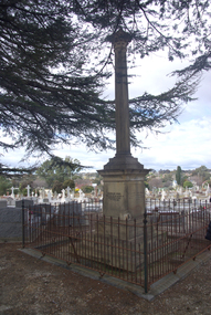
Photograph - Photograph - Colour, Burke and Wills Memorial at Bendigo Cemetery, 2018, 02/09/2018
Robert O'Hara Burke and Thomas Pope Besnard were childhood friends. As sexton of the local Back Creek Cemetery Thomas Besnard organised a subscription to raise the money for a monument to Burke, Wills and Gray. A subscription of one shilling, no more and not less, was asked so all subscribers were equal. The Bendigo monument was designed by Adam Duncan and features a Corinthian column mounted on a foundation stone, topped with a Grecian urn draped with the Union Jack. The stone for the monument was quarried from New Chum Mine. The site in the Bendigo Cemetery was selected by Besnard so the monument was on a grass knoll well clear of any other graves. The design included landscaping with a path and garden beds that provided dignified access. The Burke and Wills Monument in Bendigo has been entered on the Register of the National Estate as being important for its association with historical events and developments associated with exploration in the early days of Colony of Victoria. Two conifers remain from the original group sent by Mueller of the Melbourne Botanical Gardens to develop the garden layout on the knoll. These two trees are listed as Significant Trees by City of Greater Bendigo. The foundation block was laid on 20 August 1862 by Chairman of the Bendigo Municipality, Charles Burrows – exactly two years after the Expedition left Melbourne. A half day holiday was declared by Bendigo Council, and a procession left the Bendigo Town Hall and marched to the cemetery where 8000 people were gathered and another 4000 lined the route. John King was unable to attend due to ill health. Chairman of the Municipality of Bendigo, Charles Burrows, gave a long address, and diaries of members of the expedition, the Sandhurst Almanac, the Bendigo Advertiser, the Bendigo Independent Evening News, photographs of the deceased, photographs of Public Buildings in Bendigo, a Sydney half sovereign and all the silver coins of the Realm were wrapped in a Union Jack and placed in a niche in the foundation stone. Fifteen months later a column was erected on the foundation stone after Besnard openly criticised the Memorial Committee for their lack of action. The Bendigo Advertiser was disappointed at the location of the monument preferring a more central location and in 1893 an attempt was made to move the monument to Rosalind Park. On 19 May 1893, Mr Minto, the City Surveyor of the Bendigo MunicIpality reported it would cost £25, and no other action occurred. In 1940 the land around the memorial was sold off as grave sites and the paths and garden beds disappeared with graves now surrounding the base of the monument. The Burke and Wills Monument in Bendigo Cemetery was entered on the Register of the National Estate for its association with historical events and developments associated with exploration in the early days of Colony of Victoria. Two conifers remain from the original group sent by Mueller of the Melbourne Botanical Gardens to develop the garden layout on the knoll. These two trees are listed as Significant Trees by City of Greater Bendigo.Burke and Wills Memorial at Bendigo Cemetery, 2018Erected by the people of Bendigo in honor of the Victorian Explorers, Burke, Wills, Gray and King who first crossed the continent of Australia. King alone surviving the privation and suffering under which his three brave ill-fated companions sank. A.D. 1862. Robert O'Hara Burke, leader of the Victorian Expedition, left Melbounre 24th August 1860. Reached Carpentaria 12th Feby 1861. Died on his return at Coopers Creek, 30th June 1861. Charles Gray, died also on his return at Polygorum Swamp. 17th April 1861. William John Wills, second in command, died also near Coopers Creek, 29th June 1861. bendigo cemetery, burke and wills, burke and wills memorial, william john wills, john o'hara burke, charles gray, polygonum swamp, coopers creek, victorian expedition, carpentaria, bendigo public cemetery, bendigo remembrance park, thomas pope besnard -
 Ballarat Heritage Services
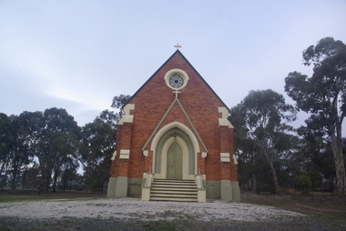
Photograph - Photograph - Colour, Lisa Gervasoni, St Laurence O'Toole Catholic Church, Sandon, 2017, 16/07/2017
St Laurence O'Toole church and cemetery is located in a rural setting at 801/821 Creswick-Newstead Rd, Sandon. Originally a small wooden school (22’x14’) was erected in Sandon by Father Patrick Smyth (who was involved in the Eureka Stockade movement) in 1859. It was also used for Mass and became known as a chapel. In June 1882 tenders were called for the construction of a brick Church by the Castlemaine architect, T.F. Kibble, and it was built at a cost of 1000 pounds. The church was blessed by Archbishop Goold on 06 May 1883 and dedicated to St Laurence O'Toole. The brick building demonstrates original design qualities of a Victorian Rudimentary Gothic style, including the steeply pitched, parapet gable roof form, together with a central steeply pitched, gabled porch that projects slightly from the main gable end. Other intact qualities include the exposed brick wall construction, lapped galvanised corrugated iron roof cladding, minor gabled porch at the rear, small ventilation dormers nearby the roof ridgeline, series of stone steps that lead to the central porch with its double pointed door opening and vertical boarded doors, simple rose window in the main gable end, pointed windows, brick buttresses with double lower copings, and the light masonry detailing (the banding marking the floor level within, buttress copings, window and door surrounds and quoins, and the drip moulds).(Shire of Mount Alexander: Heritage Study of the former Shire of Newstead, 2000) The visually connected cemetery demonstrates important visual qualities formed by the regular rows of graves and cemetery architecture, and the grassed and treed rural landscape. It is a rare and substantially intact example of a Victorian Catholic Church with a cemetery in its churchyard. Many headstones and cemetery architecture, date from the 19th century and represent some fine examples of masonry craftsmanship. Some refurbisments occurred during the 1940s and in 2002 a major restoration project was undertaken from roof to footings, by a dedicated band of volunteers and trades people. Work was completed mid 2003 and in November 2003 St Laurence’s was re-dedicated with the celebration of Mass and a picnic tea. Colour photograph of a brick church at Sandon, Victoria.sandon, sandon cemetery, st laurence o'toole catholic church, sandon -
 Ballarat Heritage Services
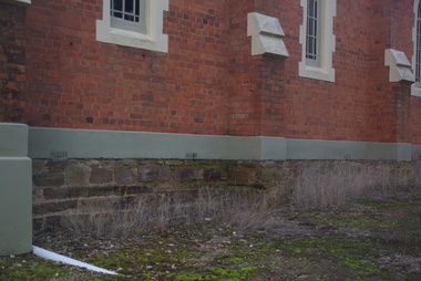
Photograph - Photograph - Colour, Clare Gervasoni, Sandstone foundations at St Laurence O'Toole Catholic Church, Sandon, 2017, 16/07/2017
St Laurence O'Toole church and cemetery is located in a rural setting at 801/821 Creswick-Newstead Rd, Sandon. Originally a small wooden school (22’x14’) was erected in Sandon by Father Patrick Smyth (who was involved in the Eureka Stockade movement) in 1859. It was also used for Mass and became known as a chapel. In June 1882 tenders were called for the construction of a brick Church by the Castlemaine architect, T.F. Kibble, and it was built at a cost of 1000 pounds. The church was blessed by Archbishop Goold on 06 May 1883 and dedicated to St Laurence O'Toole. The brick building demonstrates original design qualities of a Victorian Rudimentary Gothic style, including the steeply pitched, parapet gable roof form, together with a central steeply pitched, gabled porch that projects slightly from the main gable end. Other intact qualities include the exposed brick wall construction, lapped galvanised corrugated iron roof cladding, minor gabled porch at the rear, small ventilation dormers nearby the roof ridgeline, series of stone steps that lead to the central porch with its double pointed door opening and vertical boarded doors, simple rose window in the main gable end, pointed windows, brick buttresses with double lower copings, and the light masonry detailing (the banding marking the floor level within, buttress copings, window and door surrounds and quoins, and the drip moulds).(Shire of Mount Alexander: Heritage Study of the former Shire of Newstead, 2000) The visually connected cemetery demonstrates important visual qualities formed by the regular rows of graves and cemetery architecture, and the grassed and treed rural landscape. It is a rare and substantially intact example of a Victorian Catholic Church with a cemetery in its churchyard. Many headstones and cemetery architecture, date from the 19th century and represent some fine examples of masonry craftsmanship. Some refurbisments occurred during the 1940s and in 2002 a major restoration project was undertaken from roof to footings, by a dedicated band of volunteers and trades people. Work was completed mid 2003 and in November 2003 St Laurence’s was re-dedicated with the celebration of Mass and a picnic tea. Details of the exterior of St Laurence O'Toole Catholic Church, Sandon in Central Victoria.sandon, sandon cemetery, st laurence o'toole catholic church, sandon, sandstone, foundations -
 Ballarat Heritage Services
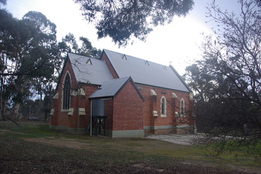
Photograph - Photograph - Colour, Clare Gervasoni, St Laurence O'Toole Catholic Church, Sandon, 2017, 16/07/2017
St Laurence O'Toole church and cemetery is located in a rural setting at 801/821 Creswick-Newstead Rd, Sandon. Originally a small wooden school (22’x14’) was erected in Sandon by Father Patrick Smyth (who was involved in the Eureka Stockade movement) in 1859. It was also used for Mass and became known as a chapel. In June 1882 tenders were called for the construction of a brick Church by the Castlemaine architect, T.F. Kibble, and it was built at a cost of 1000 pounds. The church was blessed by Archbishop Goold on 06 May 1883 and dedicated to St Laurence O'Toole. The brick building demonstrates original design qualities of a Victorian Rudimentary Gothic style, including the steeply pitched, parapet gable roof form, together with a central steeply pitched, gabled porch that projects slightly from the main gable end. Other intact qualities include the exposed brick wall construction, lapped galvanised corrugated iron roof cladding, minor gabled porch at the rear, small ventilation dormers nearby the roof ridgeline, series of stone steps that lead to the central porch with its double pointed door opening and vertical boarded doors, simple rose window in the main gable end, pointed windows, brick buttresses with double lower copings, and the light masonry detailing (the banding marking the floor level within, buttress copings, window and door surrounds and quoins, and the drip moulds).(Shire of Mount Alexander: Heritage Study of the former Shire of Newstead, 2000) The visually connected cemetery demonstrates important visual qualities formed by the regular rows of graves and cemetery architecture, and the grassed and treed rural landscape. It is a rare and substantially intact example of a Victorian Catholic Church with a cemetery in its churchyard. Many headstones and cemetery architecture, date from the 19th century and represent some fine examples of masonry craftsmanship. Some refurbisments occurred during the 1940s and in 2002 a major restoration project was undertaken from roof to footings, by a dedicated band of volunteers and trades people. Work was completed mid 2003 and in November 2003 St Laurence’s was re-dedicated with the celebration of Mass and a picnic tea. Brick church at Sandon, Victoriasandon, sandon cemetery, st laurence o'toole catholic church, sandon -
 Ballarat Heritage Services
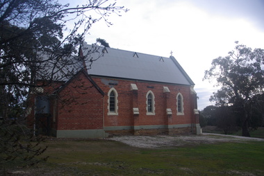
Photograph, Clare Gervasoni, St Laurence O'Toole Catholic Church, Sandon, 2017, 16/07/2017
St Laurence O'Toole church and cemetery is located in a rural setting at 801/821 Creswick-Newstead Rd, Sandon. Originally a small wooden school (22’x14’) was erected in Sandon by Father Patrick Smyth (who was involved in the Eureka Stockade movement) in 1859. It was also used for Mass and became known as a chapel. In June 1882 tenders were called for the construction of a brick Church by the Castlemaine architect, T.F. Kibble, and it was built at a cost of 1000 pounds. The church was blessed by Archbishop Goold on 06 May 1883 and dedicated to St Laurence O'Toole. The brick building demonstrates original design qualities of a Victorian Rudimentary Gothic style, including the steeply pitched, parapet gable roof form, together with a central steeply pitched, gabled porch that projects slightly from the main gable end. Other intact qualities include the exposed brick wall construction, lapped galvanised corrugated iron roof cladding, minor gabled porch at the rear, small ventilation dormers nearby the roof ridgeline, series of stone steps that lead to the central porch with its double pointed door opening and vertical boarded doors, simple rose window in the main gable end, pointed windows, brick buttresses with double lower copings, and the light masonry detailing (the banding marking the floor level within, buttress copings, window and door surrounds and quoins, and the drip moulds).(Shire of Mount Alexander: Heritage Study of the former Shire of Newstead, 2000) The visually connected cemetery demonstrates important visual qualities formed by the regular rows of graves and cemetery architecture, and the grassed and treed rural landscape. It is a rare and substantially intact example of a Victorian Catholic Church with a cemetery in its churchyard. Many headstones and cemetery architecture, date from the 19th century and represent some fine examples of masonry craftsmanship. Some refurbisments occurred during the 1940s and in 2002 a major restoration project was undertaken from roof to footings, by a dedicated band of volunteers and trades people. Work was completed mid 2003 and in November 2003 St Laurence’s was re-dedicated with the celebration of Mass and a picnic tea. Colour photograph of a red brick church in Sandon. sandon, sandon cemetery, st laurence o'toole catholic church, sandon -
 Ballarat Heritage Services
Photograph - Photograph - Colour, Clare Gervasoni, Treed road behind St Laurence O'Toole Catholic Church, Sandon, 2017, 16/07/2017
St Laurence O'Toole church and cemetery is located in a rural setting at 801/821 Creswick-Newstead Rd, Sandon. Originally a small wooden school (22’x14’) was erected in Sandon by Father Patrick Smyth (who was involved in the Eureka Stockade movement) in 1859. It was also used for Mass and became known as a chapel. In June 1882 tenders were called for the construction of a brick Church by the Castlemaine architect, T.F. Kibble, and it was built at a cost of 1000 pounds. The church was blessed by Archbishop Goold on 06 May 1883 and dedicated to St Laurence O'Toole. The brick building demonstrates original design qualities of a Victorian Rudimentary Gothic style, including the steeply pitched, parapet gable roof form, together with a central steeply pitched, gabled porch that projects slightly from the main gable end. Other intact qualities include the exposed brick wall construction, lapped galvanised corrugated iron roof cladding, minor gabled porch at the rear, small ventilation dormers nearby the roof ridgeline, series of stone steps that lead to the central porch with its double pointed door opening and vertical boarded doors, simple rose window in the main gable end, pointed windows, brick buttresses with double lower copings, and the light masonry detailing (the banding marking the floor level within, buttress copings, window and door surrounds and quoins, and the drip moulds).(Shire of Mount Alexander: Heritage Study of the former Shire of Newstead, 2000) The visually connected cemetery demonstrates important visual qualities formed by the regular rows of graves and cemetery architecture, and the grassed and treed rural landscape. It is a rare and substantially intact example of a Victorian Catholic Church with a cemetery in its churchyard. Many headstones and cemetery architecture, date from the 19th century and represent some fine examples of masonry craftsmanship. Some refurbisments occurred during the 1940s and in 2002 a major restoration project was undertaken from roof to footings, by a dedicated band of volunteers and trades people. Work was completed mid 2003 and in November 2003 St Laurence’s was re-dedicated with the celebration of Mass and a picnic tea. Colour photograph of bushland behind a church at Sandon, Victoria.sandon, sandon cemetery, st laurence o'toole catholic church, sandon, landscape, road -
 Ballarat Heritage Services
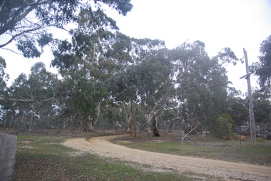
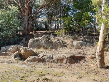
Photograph - Photograph - Colour, Clare Gervasoni, Pulpit Rock, Magpie, Victoria, 2019, 18/05/2019
Wesleyans at Magpie collected money to built a tent chapel at Magpie, but the rush had moved on before it was erected so the tent was taken to Ballarat where it becme the basis of the Lydiard Street Wesleyan Church (now Uniting Church). A bluestone church was later bulit above the Magpie School which was demolished in the 1960s with the stone used in the entrance building at Sovereign Hill.A large rock at Magpie, beside the Yarrowee Creek, was called Pulpit Rock. It was at this rock that the early miners gathered in 1853 for open air religious services. magpie, wesleyan church, religion, pulpit rock, geology -
 Ballarat Heritage Services
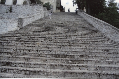
Digital photograph, Dorothy Wickham, Steps at Lake Bled, Slovenia, 2007
The lake surrounds Bled Island (Blejski otok). The island has several buildings, the main one being the pilgrimage church dedicated to the Assumption of Mary (Cerkev Marijinega vnebovzetja), built in its current form near the end of the 17th century, and decorated with remains of Gothic frescos from around 1470 in the presbyterium and rich Baroque equipment. The church has a 52 m (171 ft) tower and there is a Baroque stairway dating from 1655 with 99 stone steps leading up to the building. The church is frequently visited and weddings are held there regularly. Traditionally it is considered good luck for the groom to carry his bride up the steps on the day of their wedding before ringing the bell and making a wish inside the church. The traditional transportation to Bled Island is a wooden boat known as a pletna. The word pletna is a borrowing from Bavarian German Plätten 'flat-bottomed boat'. Some sources claim the pletna was used in Lake Bled as early as 1150 AD, but most historians date the first boats to 1590 AD. Similar in shape to Italian gondolas, a pletna seats 20 passengers. Modern boats are still made by hand and are recognizable by their colorful awnings. Pletna oarsman employ the stehrudder technique to propel and navigate boats across the lake using two oars. The role of the oarsman dates back to 1740, when Empress Maria Theresa granted 22 local families exclusive rights to ferry religious pilgrims across Lake Bled to worship on Bled Island. The profession is still restricted. Many modern oarsman descend directly from the original 22 families. https://en.wikipedia.org/wiki/Lake_BledDigital photographlake bled, church, stairway, steps, slovenia, stone, tradition -
 Ballarat Heritage Services
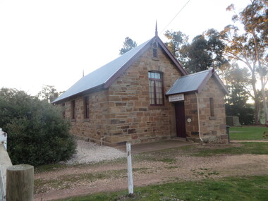
Photograph - Colour, Clare Gervasoni, Former Clydesdale State School (now Clydesdale Hall), 2018, 14/05/2018
The Clydesdale War Memorial is an obelisk situated in the Clydesdale State Shool grounds (now the Clydesdale Hall). The 150th anniversary of the Clydesdale State School/Hall was celecbrated in 2017. A number of colour photograph of a sandstone building that was built of local stone as the Clydesdale State School (SS900). It is now the Clydesdale Hall. clydesdale, world war one, world war two, clydesdale state school, clydesdale hall, sandstone -
 Hume City Civic Collection
Photograph - Gate House or he Lodge
The building is the former Gate House or Lodge that is at the gates at Rupertswood in Macedon Street. A lodge was often erected at the entrance of a large estate to direct guests to the mansion or reject unauthorised people from entering the property. The presence for a Gatehouse or Lodge erected at the entrance of a larger property was a tradition copied by wealthy landowners in the Colony from one practised by the upper classes in Britain. A coloured photograph of blue stone top storey cottage with a slate roof surrounded by an attractive garden. The building has 3 chimneys and there is a smaller single storey wing added to the building.the lodge, the gatehouse, rupertswood, macedon street -
 Hume City Civic Collection
Book, Saltwater River History Trails
This book which was printed in 1984 gives not only the geology of the area but also the history of the various areas that Jacksons Creek and the Saltwater River now known as the Maribyrnong River pass through. There are many drawings and photos accompanying the information relating to the various areas and buildings researched in this book. From Sunbury to Williamstown some of the names and places mentioned include John Aitken, George Evans, William J.T. Clarke, Ben Eadie, Rupertswood, Goonawarra Vineyard, Organ Pipes, Glenara, Walter Clark, Keilor, Overnewton, Avondale Heights, Solomons ford, Riverview Tea Gardens, Anglers Hotel, Aberfeldie Park, Humes Pipe Works, Powder Magazine, Maribyrnong, Munitions factories, Footscray Park, Flemington, Footscray, Yarraville, Newport, Williamstown, Commonwealth reserve, the blue stone lighthouse. A small cream/olive green colour covered printed book of 74 pages. The front cover shows part of a pen and wash drawing of a homestead. It has the name of the book and the author Hugh Anderson printed at the top of the cover and Sunbury to the Sea printed at the bottom. There are many drawings and photos included in the book.SALTWATER RIVER/HISTORY TRAILS/HUGH ANDERSON/Sunbury to the Seasaltwater river, maribyrnong river, jacksons creek, anderson hugh, sunbury, keilor, organ pipes national park, solomons ford, riverview tea gardens, humes pipe works, powder magazine, footscray, yarraville, newport, williamstown -
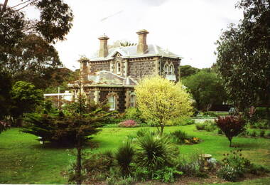
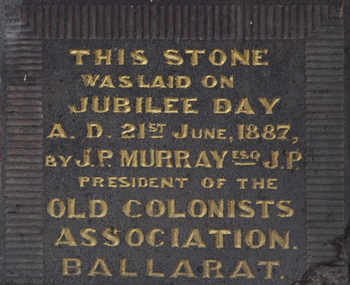 Old Colonists' Association of Ballarat Inc.
Photograph - Photograph - Colour, Clare Gervasoni, Old Colonists' Association Ballarat Foundation Stone, 09/05/2015
The Foundation Stone was laid in 1887.Colour photograph of a bluestone foundation stone with gold writing. It is the foundation Stone of the Old Colonists' Association Ballarat building in Lydiard Street North, Ballarat.This stone was laid on Jubilee Day A.D. 21st June, 1887, by J.P. Murray esq J.P. President of the Old Colonsts Association. Ballaratold colonists' association ballarat, ballarat old colonists; club, j.p. murray, architecture, foundation stone -
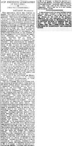 Old Colonists' Association of Ballarat Inc.
Photograph - Newsclipping, The Old Colonists' Association of Ballarat, 1888, 1888
The Old Colonists' Association Ballarat Inc. is a not for profit charitable organisation providing accommodation for elderly people. It manages a 27 Home retirement village at Charles Anderson Grove Ballarat. Accommodation is offered at significantly below market rates. It has been providing low cost accommodation to the elderly since the 1920s. The Association Council overseas the running of this facility on a voluntary basis. OLD COLONISTS' ASSOCIATION OF BALLARAT. (FROM OUR CORRESPONDENT.) BALLARAT, WEDNESDAY. This association, which was founded in August, 1883, and at first known as the Old Identities' Association, now has a roll of 450 members. The objects of the association are "to aid and assist indigent or suffering old colonists ; to raise a fund, by the voluntary subscriptions of the members and the aid of outside donations, for the purpose of relieving members in sickness and old age; for assisting those in extreme distress, to provide the shelter of a home for old and indigent pioneers of the gold fields, their widows, or anyone connected with the association, and in the event of the death of any member to have his remains decently buried, the association defraying the expenses of the funeral (providing that no funds or property are left by the deceased), and to attend the funeral if so desired by the relatives." The qualifications for member ship are good character and repute, and residence in the colonies for a quarter of a century. For some time the association had no property except the regular subscriptions, but about a year ago they obtained from the Minister of Lands the grant of a very valuable block of land in Lydiard-street, the Crown grant of which they received last week. This block has a frontage of 66ft to Lydiard street, worth at least £100 a foot. The ground was given to the association as a site for them to build a hall upon, and with so valuable an asset they had no difficulty in borrowing at 7 per cent, enough money to construct a hall. For revenue purposes the ground floor of the building has been made into four shops, and the rental from these, judging from the rentals of shops in the vicinity, will not only pay all the interest on the borrowed money, but over £200 a year towards clearing off the principal. The officers of the association are Messrs J. P. Murray, President; J. W. Graham and T. Stoddart, vice presidents; D. Fern, treasurer; and J. Fraser, secretary. The Old Colonists' Hall is an elegant looking building in Lydiard-street, lying between the newly-opened mining exchange and the Commercial Club house, and a few doors north of the Post Office. The style of the facade is classic. The lower portion of the front is constructed of Waurn Ponds stone, forming piers, and the upper portion of brick and cement, the background being tuckpointed. The centre bay is carried by two three quarter columns with Ionic cups, which support a pediment on which is set a cast of the Ballarat coat of arms. The four other bays are supported by pilasters with Corinthian caps mid partly fluted. The entrance is through a spacious circular headed doorway, the keystone of the arch of which bears a sculptured head, in marble, representing that of the president of the Old Colonists' Association here, Mr. John P. Murray. An ample vestibule leads to a wide stone staircase which ends at a spacious landing. The landing has a dome over the centre, with cornice and enrichments, and is lighted from above. The walls round the landing are panelled with marble slabs, which are to be appropriately inscribed in the future. On the first door are the rooms appropriated to the association. The principal of these is a hall 44ft x 33ft and 17ft high. This room is well ventilated and lighted from the back of the building with large windows, and the walls are finished with Keene's cement. The other rooms are committee room, 14ft x 16ft; secretary's, 14ft x 17ft, 6in; kitchen, bedrooms, bathroom, &c. The front portion of the first floor is arranged so that it may be let for offices, or utilised for club purposes. Suitable provision has been made throughout for lighting, ventilation, and means of egress. The architect for the edifice is Mr A. G. Legge, of this city, and the contractors are Messrs. Whitelaw and Atkinson, Irving and Glover, Reynolds, and J. Donaldson. The total cost of the building when completed, which will be in a few weeks, will be about £4,000. (The Argus, 10 May 1888)ballarat old colonists' club, charles anderson grove, old colonists' association -
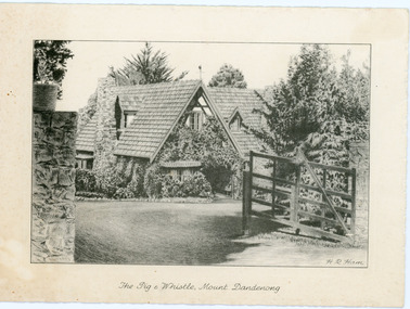 Mt Dandenong & District Historical Society Inc.
Photograph, The Pig & Whistle, Mount Dandenong
The sketch of the Pig & Whistle would be pre1968 as the gate was remodeled with two white half gates at this time and the ivy removed. The building was purchased in 1968 by the Benash family and renovated inside and out with a white, Tudor style outer facade. It was renamed Tatra Hut. The restaurant was sold again c1975 and became a Reception Centre. This information was provided by Victor Grotaers who was the resident solo-accordionist in 1968 when the new Tatra Hut opened. He recalls the opening night as being a large affair reported by Channel 9 at the time.Copy of a pencil sketch of 'The Pig & Whistle' restaurant at Mt Dandenong. The building still stands but became the Tatra Hut c1968. The sketch is signed H.R. Ham. The sketch shows the front of the restaurant with gate and stone pillars.On front of card: The Pig & Whistle, Mount Dandenongpig & whistle, tatra hut, restaurant, mt dandenong, mount dandenong, sketch, h.r.ham -
 Mt Dandenong & District Historical Society Inc.
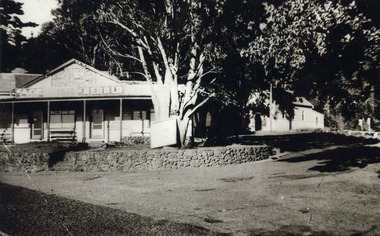
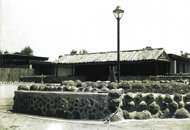
Photograph, FiveWays Tea-rooms/Newsagency and Methodist Chuch c1925, c1925
Early view of FiveWays Tea-rooms showing the stone embankment and the Methodist Church. The Newsagent and Post office was in the Tea Rooms building but around the cornerEarly view of FiveWays Tea-rooms showing the stone embankment and the Methodist Churchfiveways, kalorama methodist church, newsagency, post office, tea rooms -
 Department of Health and Human Services
Photograph, A stone wall, landscaping, & buildings, all constructed by residents circa 1970s at Sandhurst Training Centre
... Melbourne melbourne A stone wall, landscaping, & buildings, all ... -
 Southern Sherbrooke Historical Society Inc.
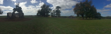
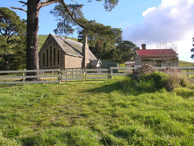
Photograph, Visit to Mt Heatherly, early 2000s
Photos of Mt Heatherly, an historical building in Belgrave, opposite Belgrave Lake Park. Address is Park Drive, on the corner of Waratah Ave. The house is now owned by Mrs Elizabeth Schneider, and was first constructed around 1881 by the first owner of the selection, Ormond Smith. It was made of hand-made bricks made on site, and a foundation of rock and stone. The original house may have had a corrugated iron roof. The original house forms part of the modern house. Photos taken in early 2000s by Susan Heywood-Downard.