Showing 11976 items matching " vic.)"
-
 Glen Eira Historical Society
Caulfield Properties
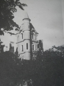
Photograph of Crotonhurst mansion, date unknowncaulfield, crotonhurst, mansions -
 Glen Eira Historical Society
Caulfield Properties
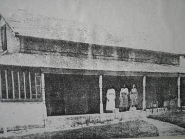
Photograph of Mood Kee, home of Harold Pennington, date unknwoncaulfield, mood kee, houses, pennington, harold -
 Glen Eira Historical Society
Caulfield Properties
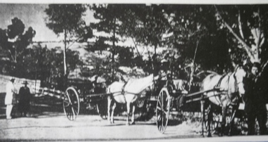
Newspaper photograph of horse drawn buggies in Orrong Road showing rural Caulfield, circa 1857caulfield, orrong road, buggies, horses -
 Eltham District Historical Society Inc
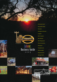
Book, Bush Telegraph Colour Business Guide 2003, 2003
Second publication following the success of the 2002 edition, aims to provide the local community with a comprehensive resource, promoting local businesses and services. This edition has broadened the demographic to include 14 suburbs.Soft cover book of colour display advertisements for business's located in Chirnside Park, Doncaster East, Donvale, Kangaroo Ground, Lilydale, Nth Croydon, Nth Eltham, Nth Ringwood, Park Orchards, Research, Templestowe, Warrandyte, Warranwood and Wonga Park areas arranged by category as listed in the contents page. Includes a sprinkling of historical images and brief descriptions of each area. Also includes lists of Child care, Churches, coming events and schools. 63 pagesbusiness directory, chirnside park, doncaster east, donvale, kangaroo ground, lilydale, nth croydon, nth eltham, nth ringwood, north eltham, park orchards, research (vic.), templestowe, warrandyte, warranwood, wonga park -
 Eltham District Historical Society Inc
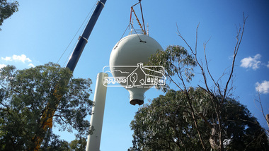
Photograph, Demolition of water tower at 51 Cassells Road, Research, 6 April 2017, 6/4/2017
"The water storage tank (the ‘golf ball’ tower) was located in Cassells Road, and for many years it played an important role in supplying the Research and Eltham communities with drinking water. However, due to prior upgrades of water supply infrastructure in the area, these communities are receiving their water supply in a more reliable way. The storage tank was no longer operating and as it no longer served a purpose, the time had come for it to be removed. Decommissioning works occurred between November 2016 and January 2017, and the tower was removed in March 2017." Source: Yarra Valley Water Eltham Water Project onlineDigital files only (17 jpg and one two second MP4 files)cassells road, demolition, research (vic.), water tower -
 Eltham District Historical Society Inc
Folder, Pioneers & Painters; Shire of Eltham Historical Society research notes, background information, etc, 1969-1986, 1969-1986
Material pertaining to the production of a history of the Shire of Eltham, "Pioneers & Painters: One Hundred Years of Eltham and its Shire" in recognition of the shire's centenary in 1971 Item Title Caption 04768-1 Newspaper clipping - The Eltham of 1905; Gellibrand our first white visitor? Diamond Valley News, 24 June 1969, p5 04768-2 Newspaper clipping - The Eltham of 1905; Gellibrand our first white visitor? Heidelberger, 25 June 1969 04768-3 Notes on Eltham District Road Board Members 1866-1871 04768-4 Notes on Eltham District Road Board Members 1866-1871 04768-5 Map showing Gellibrand's likely route through district 12-13 February 1836 and Hoddles's route of Febrary 1838 04768-6 Notes by Shire Secretary, M.B. Watson regarding meeting with Reverend Longfield regarding history of St Margaret's Church 04768-7 Alan Marshall's notes from discussion with Mr. F. Barrett regarding SEPP images 611, 635 and 636 SEPP_0611 SEPP_0635 SEPP_0636 04768-8 Transcripts of letter from local residents to Charles Joseph Latrobe requesting a bridge over the Plenty River dated 10 April 1849 and his reply dated 5 May 1849; from Latrobe Library Archives - Land Branch Records 04768-9 Notes on history of Eltham Shire, Centenary events and publication of Pioneers & Painters for release in conjunction of opening of new Library 04768-10 Newspaper clipping - Glossy record of shire's romantic past and the people who made it by Fab Calafuri, Diamond Valley News, Tuesday, December 16, 1986, p18 SEPP_0755-3 Letter: Acknowledgement from Colin J. Bock, Eltham Shire Secretary to A.R. Thomas of Bendigo for copy of 1913 photograph of Shire of Eltham Councilors, 21 May 1973 A.R. Thomas' father Mr. A.G. Thomas, C.E., was the Shire Secretary at the time in 1913. Cross Ref: SEPP_0755 The idea to develop a book on the history of the Shire of Eltham to be edited by noted author, Alan Marshall in celebration of the shire's centenary was initiated in 1969. The Shire of Eltham Historical Society undertook significant research in conjunction with Alan Marshall locating material at various institutions and other societies; interviewing longer term residents and a public campaign through the local press to acquire photographic material for duplication and use in the book. The public campaign received generous response and the material collected became the genesis for the Shire of Eltham Pioneers Photograph collection now held in partnership between Eltham District Historical Society and Yarra Plenty Regional Library (Eltham Library).Paper documents of various sizes and newspaper clippingsa.g. thomas, a.r. thomas, alan marshall, bridge road, charles joseph latrobe, council members, d.w. lachlan, eltham district road board, eltham shire council, ernie orford, f. barrett, francis rogerson, g. bransprone, james donaldson, james johnston, john bell, john thomson, joseph tice gellibrand, lower plenty bridge, m.b. watson, main road, map, patrick turnbull, peter morris, pioneers and painters, post office, rev. longfield, sepp, shire of eltham pioneers photograph collection, shire secretary, st margaret's church, thomas armstrong, thomas bell, thomas sweeney, william bell (1796-1870), centenary celebrations, christmas hills, clifton pugh, david newbury, dudley street, eltham, gareth jones roberts, hurstbridge, john perceval, joy peck, kangaroo ground, kinglake, lower plenty, luther haley general store, montmorency, neil douglas, panton hill, peter glass, research (vic.), sheila ferguson, shire of eltham, st andrews, yarra glen -
 Eltham District Historical Society Inc
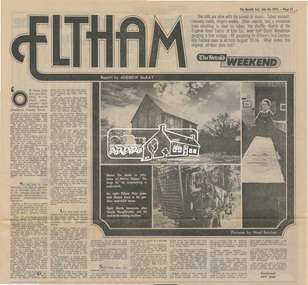
Newsclipping, Eltham, Report by Andrew Mckay, Pictures by Noel Butcher, The Herald, 26 July 1975, pp 21-22, 26 Jul 1975
Digital file only - Digitised by EDHS from a scrapbook on loan from Beryl Bradbury (nee Stokes), daughter of Frank Stokes.alistair knox, alma road, arthur munday, beryl bradbury (nee stokes) collection, cameron jackson, carina hack, charlie macgillicuddy, charlie stevenson, circus, clifton pugh, david stephens, dorian le gallienne, eltham, eltham college, eltham hotel, eltham living and learning centre, eltham town square, eltham village, george paul, graham bell, great hall, green wedge, harold holt, jazz, jim chinaman's road, justus jorgensen, kangaroo ground, lower plenty, marcus skipper, matcham skipper, montmorency, montsalvat, mud brick construction, mudbrick, myra skipper, professor dick downing, professor macmahon ball, professor richard downing, research (vic.), roger bell, shire of eltham, shire president, shopping centre, swiper's gully, tim burstall, white cloud cottage -
 Eltham District Historical Society Inc
Newsclipping, Glossy record of shire's romantic past and the people who made it by Fab Calafuri, Diamond Valley News, 16 September 1986, 16 Sep 1986
A review of Pioneers and PaintersDigital file only - Digitised by EDHS from a scrapbook on loan from Beryl Bradbury (nee Stokes), daughter of Frank Stokes.beryl bradbury (nee stokes) collection, pioneers and painters, alan marshall, centenary celebrations, christmas hills, clifton pugh, david newbury, dudley street, eltham, gareth jones roberts, hurstbridge, john perceval, joy peck, kangaroo ground, kinglake, lower plenty, luther haley general store, main road, montmorency, neil douglas, panton hill, peter glass, research (vic.), sheila ferguson, shire of eltham, shire of eltham pioneers photograph collection, st andrews, yarra glen -
 Eltham District Historical Society Inc
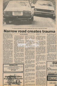
Newsclipping, Narrow road creates trauma by Jeni Downing, 1987c
News report on dangerous conditions of Reynolds RoadDigital file only - Digitised by EDHS from a scrapbook on loan from Beryl Bradbury (nee Stokes), daughter of Frank Stokes.beryl bradbury (nee stokes) collection, eltham, research (vic.), reynolds road -
 Eltham District Historical Society Inc
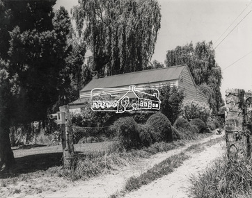
Photograph, Minces Cottage, corner of Main Road and Reynolds Road, Eltham
Minces Cottage, owned by Mrs Ivy Reynolds and rented by the Dodkins family for many years at the corner of Main Road and Reynolds Road, Eltham; Lyn Dodkins grew up in this house - now the present day (2018) site of the Eltham Motor InnDigital file - scanned from print on loan to EDHSdodkins family, eltham, eltham motor inn, ivy reynolds, lyn dodkins, main road, minces cottage, research (vic.), reynolds road -
 Eltham District Historical Society Inc
Book, Gwen Rodda, Some Roddas: Being a record of the ancestors and descendents of Nicholas Rodda, 1805-1896, 1992
The Rodda family home, Chun Grove, was located on Main Road, Eltham opposite the present BP service station at the corner of Beard Street.Digital file only (74) - Cover and pages 64-136 and explanatory letter of self published book (1992) on loan for scanning by EDHSchun grove, eltham, family history, gwen rodda, nicholas rodda, research (vic.), rodda -
 Eltham District Historical Society Inc
Document, Rodda recollections: Extract from a book written by Charles Ramsdale
From Joan Gay, daughter of Charles and Vera Ramsdale who owned the Research General StoreDigital file only - A4 photocopy of page from book on loan for scanning by EDHScharles ramsdale, doney family, doney property, general store, joan gay (nee ramsdale), research (vic.), rodda, rupert lyons, vera ramsdale -
 Eltham District Historical Society Inc
Document, Rodda recollections by Joan Gay
Joan Gay (nee Ramsdale) was the daughter of Charles and Vera Ramsdale who owned the Research General Store.Digital file only - A4 photocopy of page on loan for scanning by EDHSbranton, brinkotter poultry farm, bus services, charles ramsdale, collingwood football club, ingrams road, ivy reynolds, joan gay (nee ramsdale), jupps piggery, linden strike drive, lyon bros, milk bar, mrs hill, neil mann, research (vic.), research cricket club, research hall, research primary school, research tennis club, reynolds road, rodda, tram, vera ramsdale, wests bakery, reminscences -
 Eltham District Historical Society Inc
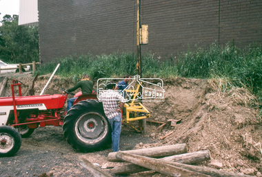
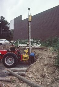
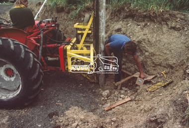
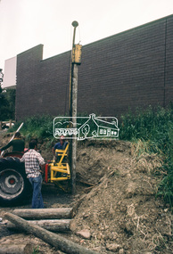
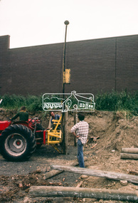
Slide - Photograph, Construction of Public Toilet, Research, c.Dec. 1980
Pile driving treated pine poles, Research Comfort Station, c.Dec. 198035mm colour positive transparency Mount - Kodak Kodachrome Cardinfrastructure, public toilets, research (vic.), research comfort station, construction -
 Eltham District Historical Society Inc
Slide - Photograph, Construction of Public Toilet, Research, c.Dec. 1980
35mm colour positive transparency Mount - Kodak Kodachrome Cardinfrastructure, public toilets, research (vic.), research comfort station, construction -
 Eltham District Historical Society Inc
Slide - Photograph, Construction of Public Toilet, Research, c.Dec. 1980
Pile driving treated pine poles, Research Comfort Station, c.Dec. 198035mm colour positive transparency Mount - Kodak Kodachrome Cardinfrastructure, public toilets, research (vic.), research comfort station, construction -
 Eltham District Historical Society Inc
Slide - Photograph, Construction of Public Toilet, Research, c.Dec. 1980
Pile driving treated pine poles, Research Comfort Station, c.Dec. 198035mm colour positive transparency Mount - Kodak Kodachrome Cardinfrastructure, public toilets, research (vic.), research comfort station, construction -
 Eltham District Historical Society Inc
Slide - Photograph, Maroondah Aqueduct, Ingrams Road, Research, c.Aug. 1978
35mm colour positive transparency Mount - Grey and Whiteaqueduct, ingrams road, maroondah aqueduct, research (vic.) -
 Eltham District Historical Society Inc
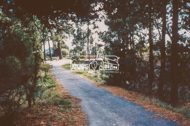
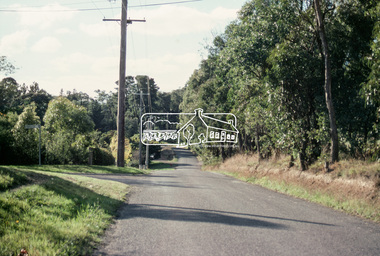
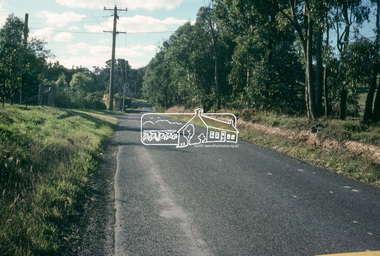
Slide - Photograph, Bells Hill Road, Research, c.May 1988
Looking north along Bells Hill Road at intersection with Kybrolyde Ct, Research, May 198835mm colour positive transparency (1 of 36) Mount - Kodak KodachromeProcess Date MAY 88Mbells hill road, infrastructure, kybrolyde ct, research (vic.), roads -
 Eltham District Historical Society Inc
Slide - Photograph, Bells Hill Road, Research, c.May 1988
Looking north along Bells Hill Road at intersection with Kybrolyde Ct, Research, May 198835mm colour positive transparency (` of 36) Mount - Kodak KodachromeProcess Date MAY 88Mbells hill road, infrastructure, kybrolyde ct, research (vic.), roads -
 Eltham District Historical Society Inc
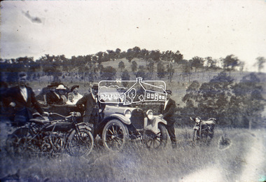
Slide, Motor Picnic, Kangaroo Ground, c.1920
Colour positive photograph taken c. Nov. 1974 of an original black and white print Indian Motor Bike, Dodge Car owned by Wraights of Kangaroo Ground (Nillumbik Historical Society)35 mm colour positive transparency Mount - Kodak Kodachrome CardProcessed Nov 1974kangaroo ground, motor picnic, motor vehicles, motorcycles, nillumbik historical society, picnic, vic registration 22115, wraight family -
 Eltham District Historical Society Inc
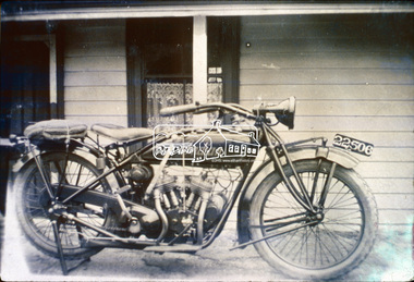
Slide, Indian Scout Motorbike owned by D. Wraight of Kangaroo Ground, c.1920
Colour positive photograph taken c. Nov. 1974 of an original black and white print Indian Motor Bike owned by D. Wraight of Kangaroo Ground (Nillumbik Historical Society)35 mm colour positive transparency Mount - Kodak Kodachrome CardProcessed Nov 1974d. wraight, indian scout, motorcycles, nillumbik historical society, vic registration 22506, kangaroo ground -
 Eltham District Historical Society Inc
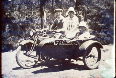
Slide, D. Wraight on his Indian Scout with sidecar, c.1920
Colour positive photograph taken c. Nov. 1974 of an original black and white print (Nillumbik Historical Society)35 mm colour positive transparency Mount - Kodak Kodachrome CardProcessed Nov 1974d. wraight, indian scout, kangaroo ground, motorcycles, nillumbik historical society, side-car, vic registration 22506 -
 Eltham District Historical Society Inc
Slide, Maroondah Aqueduct, Research, Victoria, 22 Mar. 1981
An inspection tour of the Maroondah Aqueduct was undertaken by the Shire of Eltham Historical Society on Sunday, March 22nd, 1981, commening where the aqueduct crosses Main Rd., Research, just below Eltham College. The Maroondah Aqueduct was part of Melbourne’s water supply system. It carried water over the 66 km from the Maroondah Reservoir on the Watts River at Healesville to the Preston Reservoir. Of this length, 41 km were open channel, 10 km, tunnel through hills and 15 km in 14 inverted siphons across stream valleys. The route of the aqueduct is north of Tarrawarra and Yarra Glen, along the Yarra escarpment south of Christmas Hills and crossing Watsons Creek into the present Shire of Eltham near Henley Rd. The eastern part of the route lies entirely within the former boundaries of the shire. The aqueduct passes south of Kangaroo Ground to Research and crosses the Diamond Creek by siphon at Allendale Rd., Eltham North. It then extends to Reservoir via St. Helena, Greensborough North and Bundoora. Water first flowed through the aqueduct in February 1891 when it was fed by a diversion weir on the Watts River. Records of the building of the aqueduct indicate that it was a significant construction achievement. The present Maroondah Reservoir was completed in 1927 and the aqueduct was enlarged at that time to take increased flows. About 1971 the section of the aqueduct through and north of Research was replaced by a large pipe and that section of the channel is now unused. The channel has remained largely intact (unlike sections at Greensborough and Bundoora where long lengths of the disused aqueduct have been demolished or filled in). The M.M.B.W. relinquished control of the disused aqueduct reserve which is crown land and the Shire of Eltham took control of this section of the reserve as a linear park. The Maroondah Aqueduct is considered to be an important historic structure, not just to the local area but to the metropolitan area generally. It is considered important to preserve substantially intact long lengths of the disused aqueduct, together with its bridges and other associated structures. 35 mm colour positive transparency (1 of 5) Mount - Agfachrome Agfa CS System black 8 dotsactivities, heritage excursion, maroondah aqueduct, research (vic.), shire of eltham historical society -
 Eltham District Historical Society Inc
Slide, Maroondah Aqueduct, Research, Victoria, 22 Mar. 1981
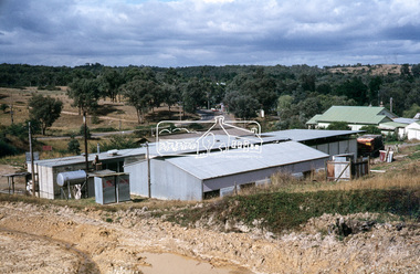
This view shows the area that would develop into the Research Industrial Estate. In centre distance though largely hidden by trees is the site of the Research Hall, which was later demolished and a new Eltham Little Theatre constructed in 1988 as a bicentennial project. The hills in the distance near the power lines now a housing estate.35 mm colour positive transparency (1 of 5) Mount - Agfachrome Agfa CS System black 8 dotsactivities, heritage excursion, maroondah aqueduct, research (vic.), shire of eltham historical society -
 Eltham District Historical Society Inc
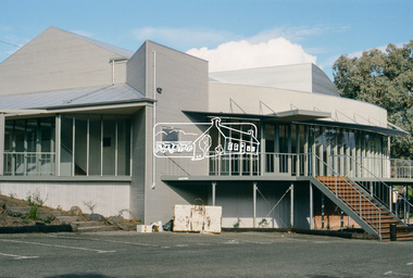
Photograph, Eltham Performing Arts Centre, 1603 Main Road, Research, c.May 1988
The Eltham Performing Arts Centre is a mult-use community facility with a seating capacity of up to 200 in the theatre mode. The project budget of $675,000 was jointly funded by the Shire of Eltham, Eltham Little Theatre Inc. and the Bicentennial Authority. Building works commenced in May 1987 and the Centre officially opened on 26th January, 1988 (Australia Day). It was constructed on the site of the old Research Hall in Main Road, Research, which was the previous home of the "Eltham Little Theatre."35mm colour positive transparency (1 of 25) Mount - Kodak EktachromeProcess Date MAY 88Meltham little theatre, eltham performing arts centre, main road, research (vic.)