Showing 24979 items matching "north"
-
 National Vietnam Veterans Museum (NVVM)
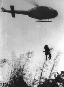
Photograph, Gibbons, Denis, Medivaced Out
Denis Gibbons (1937 – 2011) Trained with the Australian Army, before travelling to Vietnam in January 1966, Denis stayed with the 1st Australian Task Force in Nui Dat working as a photographer. For almost five years Gibbons toured with nine Australian infantry battalions, posting compelling war images from within many combat zones before being flown out in late November 1970 after sustaining injuries. The images held within the National Vietnam Veterans Museum make up the Gibbons Collection. A black and white photograph of an RAAF Huey 'slick' crew member steadying the winch wire as a wounded Digger from 8 RAR is medivaced out of thick jungle North West of the Australian Task Force at Nui Dat. The Digger has an armful of rifles belonging to some of his mates already medivaced.photograph, raaf, huey helicopter, digger, 8 rar, 1st atf base, nui dat, gibbons collection catalogue, wounded serviceman, denis gibbons, photographer, vietnam war -
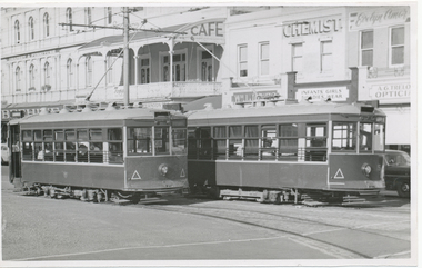
 Bendigo Historical Society Inc.
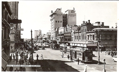
Photograph - BASIL MILLER COLLECTION: KING WILLIAM ST, SA -LOOKING NORTH
Black and white photo postcard of 3 trams on King William St, Adelaide, SA, Pipers Majestic Hotel, Roxy Delicatessen, Penfolds Wines, Krischock(?) Photographers and T&G Mutual Life Building in background. Written on back in black ink 'My Address in case is The Centralia, North Terrace, Adelaide'.basil miller, bendigo trams -
 Melbourne Tram Museum
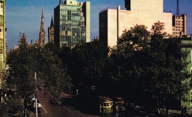
Postcard, Murray Views, W2, possibly 377, late 1950's
Postcard photo of a W2, possibly 377, at the corner of Collins and Exhibition St Melbourne with the various buildings on the north side of the street and the many trees. Divided back with places for stamp, address, correspondence and details with makers details "Murray Views of Gympie Qld, No. 10, Collins St. Melbourne, from an Ektachrome photograph.trams, tramways, collins st, exhibition st, tram 377? -
 Melbourne Tram Museum
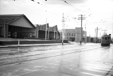
Negative, Wal Jack, c1946
Black and white negative, by Wal Jack, of W5 811 using the cross over in Mt Alexander Road in front of Essendon tram depot, c1946. Tram has the destination of Racecourse. The trams in the depot still have white fronts. Photo taken prior the construction of the new tracks on the north side of the depot.trams, tramways, essendon depot, w5 class, mount alexander road, tram 811 -
 Melbourne Tram Museum
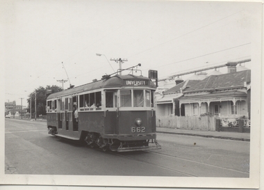
Photograph - Black & White Photograph/s, Chris Phillips, Feb. 1969
Black and white photograph of W3 662 in Holden St between Bryne and Brunswick Streets, with the North Fitzroy grain silos in the background during a special tram tour, 9/2/1969. Photo by Chris Phillips. Showing Destination of University. ARE Tour ex South Melbourne depot. Printed on Kodak Paper.On rear in red ink "W3 662 Holden St 9/2/69"trams, tramways, mmtb, special trams, holden st, tram 662 -
 National Vietnam Veterans Museum (NVVM)
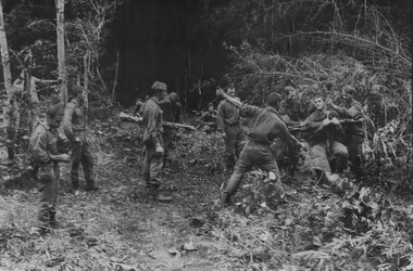
Photograph, Gibbons, Denis, Winch Extraction Preparation
Denis Gibbons (1937 – 2011) Trained with the Australian Army, before travelling to Vietnam in January 1966, Denis stayed with the 1st Australian Task Force in Nui Dat working as a photographer. For almost five years Gibbons toured with nine Australian infantry battalions, posting compelling war images from within many combat zones before being flown out in late November 1970 after sustaining injuries. The images held within the National Vietnam Veterans Museum make up the Gibbons Collection. A black and white photograph of Diggers from 1 Platoon, A Company, 8 RAR on Operation Atherton, 11 miles North West of the Australain Task Force Base, Nui Dat, prepare a wounded mate for winching out of thick jungle to be casevaced to hospital, casualities were 1 dead and 14 wounded.photograph, 1 atf, operation atherton, 1 platoon, a coy, 8 rar, dustoff, gibbons collection catalogue, australian task force, nui dat, diggers, wounded serviceman, killed in action, denis gibbons -
 National Vietnam Veterans Museum (NVVM)
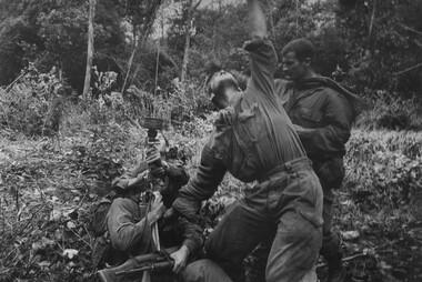
Photograph, Gibbons, Denis, Winch Extraction
Denis Gibbons (1937 – 2011) Trained with the Australian Army, before travelling to Vietnam in January 1966, Denis stayed with the 1st Australian Task Force in Nui Dat working as a photographer. For almost five years Gibbons toured with nine Australian infantry battalions, posting compelling war images from within many combat zones before being flown out in late November 1970 after sustaining injuries. The images held within the National Vietnam Veterans Museum make up the Gibbons Collection. A black and white photograph of Diggers from 1 Platoon, A Company, 8 RAR on Operation Atherton, 11 miles North West of the Australian Task Force Base, Nui Dat, signal the Dustoff crew to operate the winch for a wounded mate casevaced to hospital. Casualities were 1 dead and 14 wounded.photograph, 1 atf, operation atherton, a coy, 8 rar, dustoff, gibbons collection catalogue, digger, australian task force, nui dat, wounded serviceman, killed in action, denis gibbons -
 National Vietnam Veterans Museum (NVVM)
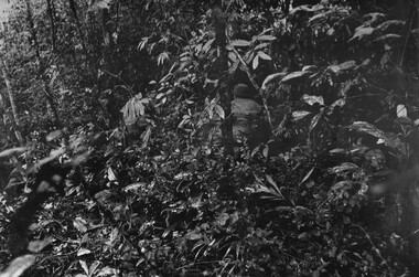
Photograph, Gibbons, Denis, Flank The Bunker
Denis Gibbons (1937 – 2011) Trained with the Australian Army, before travelling to Vietnam in January 1966, Denis stayed with the 1st Australian Task Force in Nui Dat working as a photographer. For almost five years Gibbons toured with nine Australian infantry battalions, posting compelling war images from within many combat zones before being flown out in late November 1970 after sustaining injuries. The images held within the National Vietnam Veterans Museum make up the Gibbons Collection. A black and white photograph of Contact, Contact, Contact, late afternoon,Platoon strength North West of 1ATF 'Operation Atherton' 10 December 1969. 1 Platoon, A Company 8 RAR diggers under heavy machin gun, AK47, rifle and RPG fire. A digger attempts to flank the bunker in frontphotograph, 1 atf, operation atherton, 1 platoon, a coy, 8 rar, gibbons collection catalogue, digger, machine gun, ak47, denis gibbons -
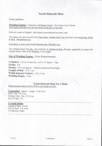 Bendigo Historical Society Inc.
Document - NORTH DEBORAH MINE - SOME STATISTICS OF THE NORTH DEBORAH MINE
BHS CollectionHandwritten pages and typed copy of same, with information about the winding engine, winding drums and measurements of winding engine and drums. Also measurements of the Lancashire and Cornish boilers at the North Deborah Mine No 1 Shaft which were measured by Ian Hendry and Self on 20/9/1970. Albert Richardson Collection.document, gold, north deborah mine, north deborah mine, some statistics on the north deborah mine, williams united, new chum line, ulster mine, garden gully line, north red white & blue, sheepshead line, deborah line, a roberts & sons bendigo, north deborah mine no 1 shaft, ian hendry -
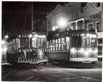 Bendigo Historical Society Inc.
Photograph - BASIL MILLER COLLECTION: TRAM - PALL MALL IN EVENING
BHS CollectionBlack and white photo of trams on Pall Mall, just off Mitchell Street corner. 'Cafe' sign on first floor verandah on immediate right of image. No 29 tram departing for North Bendigo., No 28 destined for Golden Square. Beehive building in background. Photo taken at night. Trams have lights on.basil miller, bendigo tramways, pall mall -
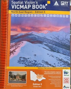 Wodonga & District Historical Society Inc
Book - Spatial Vision's VICMAP BOOK 2016 - Northeast Region, Spatial Vision Innovations Pty Ltd, 2016
This edition of Spatial Vision's VicMap Book North East Region was published in October 2016 and provides detailed topographic maps for the region. It was used by emergency services and various agencies, including the Country Fire Authority (CFA). It covers areas including Wodonga, Albury, Wangaratta, and beyond, including national parks and recreation areas. Text on the cover states that the volume is "Trusted by and produced in partnership with: Department of Environment, Land, Water & Planning, Country Fire Authority, State Emergency Service, Parks Victoria, Victoria Police".A spiral bound volume of 409 pages including colour topographic maps and illustrations of North East Victoria. The cover features a colour photo of Razorback Ridge leading to Mount Feathertop, Hotham Heights, Victoria. It also features an index map inside the front cover, a legend, road index, and locality index.This edition of Spatial Vision's VicMap Book North East Region was published in October 2016 and provides detailed topographic maps for the region. It was used by emergency services and various agencies, including the Country Fire Authority (CFA). It covers areas including Wodonga, Albury, Wangaratta, and beyond, including national parks and recreation areas. Text on the cover states that the volume is "Trusted by and produced in partnership with: Department of Environment, Land, Water & Planning, Country Fire Authority, State Emergency Service, Parks Victoria, Victoria Police".emergency management north east victoria, state emergency service, cfa wodonga -
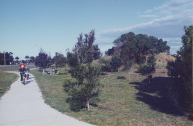 Lakes Entrance Historical Society
Photograph - Esplanade Lakes Entrance Victoria, Lakes Entrance Tidy Town, 1995 c
Colour photograph showing two children and an adult riding bicycles on pathway between south end of North Arm bridge and Bullock Island road. Middle distance left turn into Marine Parade foreground now site of skate park. In distance palm trees at entry to Esplanade Lakes Entrance Victoriarecreation, topography, roads and streets, parks -
 Wodonga & District Historical Society Inc
Domestic object - Lady's Pen and ink set, c1920s
This pen and ink set is part of a collection donated by Mrs. Jean Raper. It was used by the teacher at Upper Gundowring Primary school, Victoria. The school, number 2733, opened on 13 July 1886. Due to changing demographics in the region, in 1953 the school was merged with schools from Dederang North, Kergunyah, Gundowring, Kiewa, Red Bluff, Charleroi and Gundowing North on a 10 acre site with 11 rooms at Kiewa to become Kiewa Valley Consolidated School.This item is from Raper Collection donated to the Wodonga Historical Society by Mrs. Jean Raper. A china pen and ink set painted with a floral design.pen and ink, personal items, teacher supplies, upper gundowring primary school -
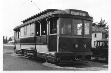 Ballarat Tramway Museum
Photograph - Ballarat tram 14 Albert St Sebastopol, 1930s or 1940s
The Photograph shows Ballarat tram No. 14 with the destination of Lydiard St North most likely in Albert St Sebastopol during the 1930s or 1940s. The tram was in the livery shown from August 1936 until Dec. 1950. A motor car is travelling on the adjacent side of the open door, which indicates possibly at the north end of Albert St, just before the tram turned into Skipton St. On the right side is a building advertising Robur Tea.Yields information about tram 14 in Albert St. Black and white prints - plain back. tramcars, tramways, tram 14, albert st -
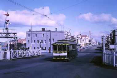 Ballarat Tramway Museum
Photograph - Digital image Set of 10, Tony Smith, 1971
Yields information about Ballarat Tramways and trams prior to the closure of the tramway system.Set of 10 digital images of Ballarat trams prior to closure, scanned from original slides by Tony Smith, 1971 prior to closure of the system. .1 - 27 crossing Lydiard St North level crossing, with Reids Coffee Palace in the background. .2 - 11 and 26? crossing at the Bell St loop - 11 has destination of Lydiard St North, Twin Lakes sign and a SEC Briquette advert. 26 - enroute to Lydiard St North. .3 - 13 in Bridge St, at Stones Corner. Tram has a Twin Lakes advertisement. Has the Bank of NSW, ? Hotel, with a JP Howard sign on the building. .4 - 26 and 27 crossing at Bell St loop. 26 has a Briquettes roof advert. .5 - 13 and 12? crossing at the Parker St loop. 13 has a Twin Lakes advert. .6 - 13 at Carlton St loop, Wendouree Parade. Has the Olympic rings in the background. .7 - 17 in Wendouree Parade, with destination of Gardens via Drummond St North, near the depot. Tram has a Twin Lakes advert. .8 - 31 turning from Wendouree Parade into Macarthur St at View point, with a shelter in the background. Tram is showing Special. .9 - 31 in Macarthur St at View Point - has destination of Victoria St. .10 - 21 enroute to Victoria St, about to cross Grenville St. Tram has the destination of Victoria St. Has the signal control box on the adjacent pole.trams, tramways, level crossings, lydiard st gates, lydiard st nth, drummond st sth, bridge st, stones corner, bell st, parker st loop, wendouree parade, carlton st, view point, macarthur st, grenville st, sturt st, tram 27, tram 11, tram 26, tram 13, tram 21, tram 31, tram 12, tram 17 -
 Ballarat Tramway Museum
Album - Photo Album, c1970
Set of 16 photos of Ballarat tram system taken 1970c on a tour by an unknown Qld based person.Photo album containing 16 colour prints. Photo album has heavy card covers, covered in black textured plastic containing 12 clear plastic photo sleeves held with a white comb binder. Photos of Ballarat prior to closure, c1970. Photographer unknown. Donated by Peter Hyde of Brisbane Tramway Museum to BTM 3/2/2010, from a deceased estate. Photos apparently taken on a tram tour. .1 - No. 42 and a single trucker inbound in Sturt St. .2 - taken from tram ascending Bakery St hill in Victoria St. .3 - End of No. 42, with the destination "Haddon St via Drummond Nth" .4 - No. 11 and 42 in Lydiard St Nth, near the railway station. No. 11 showing special. .5 - photo of three people on the tour. .6 - Trams reversing at the Victoria St terminus .7 - ditto .8 - 11, 42 and 12? in Lydiard St North by railway station. .9 - Three trams at Sebastopol terminus. .10 - View in Albert St Sebastopol looking north along the track on the side of the road. .11 - View of the tram crossing in Albert St. .12 - 27 and 42 crossing Albert St Sebastopol. .13 - View of Albert St from the tram, north of the crossing looking at the reserved track 14. - Lydiard St North looking south .15 - 42 at the railway level crossing. .16 - View south of the railway level crossing, three trams, with passengers alighting.trams, tramways, ballarat, albert st, sebastopol, victoria st, sturt st, lydiard st nth, railway crossing -
 City of Moorabbin Historical Society (Operating the Box Cottage Museum)
Clothing - Clothing, City of Moorabbin Tie, Circa 1960s
The City of Moorabbin existed from 1934 until 1994. Henry Dendy's Special Survey in 1841 of 5,120 acres in the Parish of Moorabbin , extended from Port Phillip Bay , then East to Boundary Road, South to South Road and North to North Road and became known as Brighton. 1859 Brighton became a Borough with its boundary Thomas Street ,and Bluff Road. In 1862 The Moorabbin Roads Board was formed and the extended area now included Cheltenham, Hampton, Sandringham, Black Rock, Beaumaris, Mentone and Mordialloc .and Little Brighton became known as Bentleigh. In 1871 the area became known as The Shire of Moorabbin. Gradually the area was separated into The Borough of Sandringham 1917, ( Black Rock, Beaumaris , Sandringham and Hampton ) Borough of Mentone and Mordialloc 1920, ( Parkdale ). In 1934 The City of Moorabbin was established for the area from South East corner of Thomas Street and North Road , East to Warrigal Road, Clayton Road, Kingston Road , Lower Dandenong Road, then South along Nepean Highway to Balcombe Road and along Bluff Road, Cummins Road, Nepean Highway, Thomas Street to North Road In the 1994 Amalgamation of Councils the City of Moorabbin was divided between the new City of Kingston in the South ( from South Road) and the new City of Glen Eira to the North . It was the largest Municipality in Victoria with a population of 118,865 in 1974This tie c 1960 is a memento of the City of Moorabbin 1934 - 1994Maroon colour, polyester, man's tie with the crest of City of Moorabbin woven on front.around circle enclosing Coat of Arms ; CITY OF MOORABBIN city of moorabbin, moorabbin roads board, moorabbin, brighton, dendy's special survey 1841, early settlers, pioneers, market gardners, dendy henry, were jonathan b, cheltenham, bentleigh, mentone, sandringham, mair william, bent thomas -
 Old Castlemaine Schoolboys Association Inc.
Flyer
This Bill is as phony as the McMahon Government Too many Billys - get rid of them on December 2 VOTE LABOR Authorised by H. Leonard, Seamen's Union of Australia 289A Sussex Street, Sydney North Sydney-Apollo Printing Pty Ltd -
 Ballarat Tramway Museum
Photograph - Black & White Photograph/s, Wal Jack, 12/04/1959 12:00:00 AM
Black and White print contained within the Wal Jack Bendigo and Geelong Album, see Reg Item 5003 for more details. Photo of Bendigo Birney No. 29 and 15 in Pall Mall, near Charing Cross, 12-4-1959, Photo by Wal Jack. Has in the background, The Beehive buildings, Jopp? Cafe, Wm Jones building, Chemist, and A.G. Trello? Opticians. i1 - scan of print in the album i2 - rear of image i3 - scan of negative at 3200dpi added 6/6/2020. On the rear in black ink "SEC Bendigo #29 (left) for North Bendigo, and 15 (right) for Golden Square, photographed from #28, at Pall Mall 3.40pm, Sun 12th April 1959", in bottom left hand corner "Wal Jack Photo"trams, tramways, bendigo, pall mall, charing cross, birney, tram 15, tram 29 -
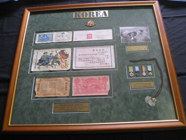 Lilydale RSL Sub Branch
Memorabilia - Framed display of George Styles memorabilia in Korea and Vietnam
Framed display of Photograph, Propaganda Leaflet, Medals and Identity Discs1 - Photograph of George Styles and Friends 2 - Miniature Medals and Identity Discs worn by George Styles whilst serving in Korea and Vietnam. 3 - North Korean and UN Propaganda leaflets dropped from planes. Donated by IRAR Max Pearce. -
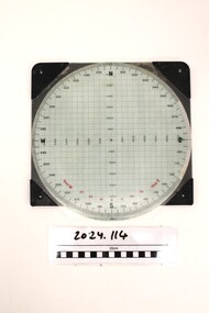 National Vietnam Veterans Museum (NVVM)
Instrument - Plotting Board, M16
Standard issue item as used by Australian servicemen during the conflict in Vietnam. A plotting board is a mechanical device used as part of a firing control system to track the observed course of a target, project its future position, and derive the azimuth (or direction) and range needed to direct the fire of the guns of a battery to hit that target.White plastic base. A circle marked with grid lines is printed on the base and a vernier for finding azimuth deflections in along top edge. Rotating disc pivots at the centre atop the disc with distances measured radially form 0 at the centre to 3400 metres around the rim range form 0-6400 metres. A scale pivoted at the centre assists in reading distances.Nth and Sth top and bottom on rotating disc. East and West in centre distances in black on outer of disc. Distances in green on inner North, South, East, West. Varn W left bottom of disc. varn E on right bottom of disc.plotting board, m16 -
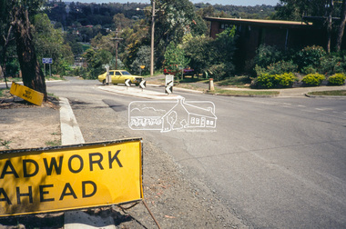
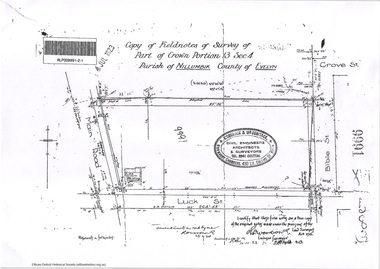 Eltham District Historical Society Inc
Document - Photocopy, Survey Fleld Notes of Part of Crown Portion 13, Section 4 at Eltham, Parish of Nillumbik, County of Evelyn, 7 January 1924
Portion of land north of Luck Street bounded by: Main Road, Bible Street Application 9991 R. Woodstock, Land Surveyor, 7 January 1924application 9991, bible street, eltham, luck street, main road, map, survey plan -
 Eltham District Historical Society Inc
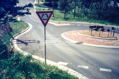
Slide - Photograph, Ryans Road, Eltham, c.1989
Ryans Road was reconstructed and sealed to the north of Kerrie Crescent in 1983. Roundabout and southern reconstruction added later. This photo is probably shortly after construction of roundabout.35mm colour positive transparency Mount - Black and Whiteeltham, infrastructure, kerrie crescent, roundabout, ryans roads -
 Eltham District Historical Society Inc
Slide - Photograph, Ryans Road, Eltham, c.1989
Ryans Road was reconstructed and sealed to the north of Kerrie Crescent in 1983. Roundabout and southern reconstruction added later. This photo is probably shortly after construction of roundabout.35mm colour positive transparency Mount - Black and Whiteeltham, infrastructure, ryans roads, burd street, meruka drive -
 Greensborough Historical Society
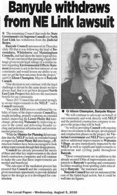
Article - Newspaper Clipping, Banyule withdraws from NE Link lawsuit
Banyule Council withdraws from the judicial review of the North East link Project, hoping to gain improvements to the Project design which will benefit the local community.News clipping, black and white text and image.north east link, banyule council, alison champion -
 Greensborough Historical Society
Newspaper Clipping, Diamond Valley Leader, Top city honour for Ray, 14/11/2018
It's been 27 years since Watsonia North's Ray Dark joined the Vic SES Northcote unit, and in that time he has seen it all.News article 1 page, black text, colour image.ray dark, watsonia north, vic ses northcote unit, state emergency service, banyule citizen of the year -
 Greensborough Historical Society
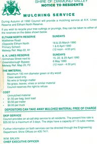
Leaflet, Notice to residents: mulching service, Shire of Diamond Valley, 1990
Notice informing residents of a mulching service located at A. K. Lines Reserve and Eltham North Reserve on selected Sunday during March, April and May 19901 p. printed in green on off-white paper shire of diamond valley, mulching -
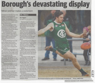 Greensborough Historical Society
Newspaper Clipping, Diamond valley Leader, Borough's devastating display, 11/09/2019
Greensborough Football Club flexed it's true muscle on Saturday, thrashing premiership rival North Heidelberg by 98 points in a major semi-final masterclass.News article 1 page, black text.northern football league, greensborough football club, north heidelberg football club -
 Greensborough Historical Society
Newspaper Clipping, Diamond Valley Leader, Home acquisition warning, 06/12/2017
Homeowners are being urged by a legal expert to exercise extreme caution ahead of the State Government's bid to buy up properties for the North East Link project.News article 1 page, black text.north east link, compulsory acquisition -
 Glenelg Shire Council Cultural Collection
Book, The Bible, n.d
Pearson Family Bible. Tan leather bound King James bible, embossed on front & Back covers. Spine also embossed and ridged horizontally. Gold lettering on spine. Gold edges to pages. Two brown satin bookmarks contains family register between Old and New Testamentsreligious text, religion, bible, family bible, pearson family, king james