Showing 8189 items matching "working"
-
 Kew Historical Society Inc
Photograph - 'Mount Eri', 9 Highbury Grove, 1919
Subdivision plans are historically important documents used as evidence of the growth of suburbs in Australia. They frequently provide information about when the land was sold on which a built structure was subsequently constructed as well as evidence relating to surveyors and real estate and financial agents. The numerous subdivision plans in the Kew Historical Society's collection represent working documents, ranging from the initial sketches made in planning a subdivision to printed plans on which auctioneers or agents listed the prices for which individual lots were sold. In a number of cases, the reverse of a subdivision plan in the collection includes a photograph of a house that was also for sale by the agent. These photographs provide significant heritage information relating house design and decoration, fencing and household gardens.A photograph of Mount Eri, 9 Highbury Grove, an 11-room house for sale near the junction of Cotham and Glenferrie Roads. The substantial red brick, slate-roofed house and its location are not identified in the photograph, although the extent of the house is noted. It was described then as ‘well situated’ and close to 3 trams. Mathers, a financial agent in Cotham Road, placed advertisements about the sale of the property in The Argus in May and June 1919. The advertisement additionally refers to a billiard room and asserts that the house has every modern convenience. An annotation on the plan indicates that the house, with tennis court, was sold for £1960. Following extensive research, the house has now been conclusively identified, albeit extended and rendered. The house was originally built in the 19th century as a school and for much of the 20th century was used as a venue for receptions. -
 Kew Historical Society Inc
Photograph - Victorian Villa, High Street, c.1922
Subdivision plans are historically important documents used as evidence of the growth of suburbs in Australia. They frequently provide information about when the land was sold on which a built structure was subsequently constructed as well as evidence relating to surveyors and real estate and financial agents. The numerous subdivision plans in the Kew Historical Society's collection represent working documents, ranging from the initial sketches made in planning a subdivision to printed plans on which auctioneers or agents listed the prices for which individual lots were sold. In a number of cases, the reverse of a subdivision plan in the collection includes a photograph of a house that was also for sale by the agent. These photographs provide significant heritage information relating house design and decoration, fencing and household gardens.An old inscription on this photograph identifies it as ‘an elegant timber villa in High Street. It occupied part of Lot 91, bought by Edward Glyn in the land sale of 16th October 1851, and run as a flower farm’. The subdivision called the ‘Flower Farm Estate’ in East Kew occurred in 1922. [The subdivision plan is on the reverse of this photo.] The Estate included 61 lots on either side of Boorool Road between High Street and Harp Road. In the MMBW Detail Plan 2017 of 1926, a number of these new villas had already been built. Matching houses with MMBW maps can always be a challenge, however if this house was near the corner of Boorool Road and High Street, it seems to fit the profile of a house called ‘Maxton’ (demolished).Photographer's name on photograph, lower right, and stamp on mount lower right: "A. Aberline, Glenferrie".houses - maxton - high street - kew (vic.), violet farm estate, subdivisions - kew (vic.) -
 Kew Historical Society Inc
Photograph - W.B. Villa, Kew, c.1919
The photograph offers significant information relating to late Victorian / Federation colour schemes and fencing.The block fronted villa has a corrugated iron roof and a flat projecting verandah, ornamented with a trellis design of timber. The front window features a timber shade, mounted on brackets. The treatment of the block-fronted panels shows that there is an attempt to highlight imitation quoining through use of a darker colour. The windows and door are also in this darker shade. The front fence and gate are made of wooden pickets. It is unlikely that the photograph was taken at the time of the villa's construction given the size of the shrub/tree in the front garden.Subdivision plans are historically important documents used as evidence of the growth of suburbs in Australia. They frequently provide information about when the land was sold on which a built structure was subsequently constructed as well as evidence relating to surveyors and real estate and financial agents. The numerous subdivision plans in the Kew Historical Society's collection represent working documents, ranging from the initial sketches made in planning a subdivision to printed plans on which auctioneers or agents listed the prices for which individual lots were sold. In a number of cases, the reverse of a subdivision plan in the collection includes a photograph of a house that was also for sale by the agent. These photographs provide significant heritage information relating house design and decoration, fencing and household gardens.A real estate photograph, mounted on brown card, showing a double fronted weatherboard villa, located in Kew, Victoria. On the reverse of the photograph is a subdivision plan for the Altyre Estate.Stamped on mount: Top - "KEW. Close tram. Fine View. / W.B. Villa Containing 8 Rooms. / Up-to-date Conveniences. EL Etc." Below - "Land 40 x 165. 615 pounds. Sold"houses - kew, real estate photographs -
 Kew Historical Society Inc
Photograph - Brick and Stucco Bungalow, J E Barnes, c.1920
The Kew Historical Society's map collection includes a substantial number of real estate subdivision plans, mainly of Kew but also of surrounding suburbs in Melbourne. Most of the subdivision plans date from the 1920s and 1930s when the districts old homes and local farmland were being split up to accommodate residential growth in the postwar period. These early plans were assembled by a local firm, Jas R Mather & McMillan, which had an office in Cotham Road. Many of the plans, and sometimes photos, were annotated by the agents.Subdivision plans are historically important documents used as evidence for the growth of suburbs in Australia. They frequently provide information about when the land was sold as well as evidence relating to surveyors and real estate and financial agents. The numerous subdivision plans in the Kew Historical Society's collection represent working documents, ranging from the initial sketches made in planning a subdivision to printed plans on which auctioneers or agents listed the prices for which individual lots were sold. In a number of cases, the reverse of a subdivision plan in the collection includes a photograph of a house that was also for sale by the agent. These photographs provide significant heritage information relating house design and decoration, fencing and household gardens.The photograph may also be aesthetically significant depending o the importance of the photographic atelier.Real estate photograph for a local agent by the Kew photographer, Josiah Earl Barnes. The photo is of a weatherboard or brick rendered bungalow with a twisted wire fence. Given Barnes' status a a Kew photographer, the house is probably locate din Kew or East Kew. Unfortunately the handwritten information on the mount bordering the photo is damaged and cannot be read. The bungalow has a gabled, tiled roof with terra cotta finials at the front of both gables. The house has a central doorway, framed by a pseudo portico supported by four wooden columns. On each side of the doorway, at the front, there are paired sash windows, which, like the half-timbered gable, are picked out in a darker colour.Handwritten, mostly illegible description by selling agent on mount surround: " .... in Diningroom, Drawing Rooms, ... Photographers details printed on mount: "J. E. Barnes / Photo / Phone 1966 Haw KEW"houses - kew, bungalows - kew, real estate photographs, j.e. barnes -- photographer -
 Kew Historical Society Inc
Photograph - Victorian Double-fronted Brock Villa, Cotham Road, c. 1919
The Kew Historical Society's map collection includes a substantial number of real estate subdivision plans, mainly of Kew but also of surrounding suburbs in Melbourne. Most of the subdivision plans date from the 1920s and 1930s when the districts old homes and local farmland were being split up to accommodate residential growth in the postwar period. These early plans were assembled by a local firm, Jas R Mather & McMillan, which had an office in Cotham Road. Many of the plans, and sometimes photos, were annotated by the agents.Subdivision plans are historically important documents used as evidence for the growth of suburbs in Australia. They frequently provide information about when the land was sold as well as evidence relating to surveyors and real estate and financial agents. The numerous subdivision plans in the Kew Historical Society's collection represent working documents, ranging from the initial sketches made in planning a subdivision to printed plans on which auctioneers or agents listed the prices for which individual lots were sold. In a number of cases, the reverse of a subdivision plan in the collection includes a photograph of a house that was also for sale by the agent. These photographs provide significant heritage information relating house design and decoration, fencing and household gardens.The photograph may also be aesthetically significant depending o the importance of the photographic atelier.Real estate photographs of a classic double-fronted late Victorian brick villa. It central location in Cotham Road, Kew enabled the selling agent to note its proximity to the tram. With seven rooms, all ‘modern conveniences’, and land of 66×167, the house was to be sold for £1100. The villa has a number of interesting features including a pattern within the slate roof as well as the use of polychrome brickwork under the eaves and on the façade. The intricacy of the cast iron lace is emphasised by the line of projecting wooden blocks above it. The picket gate is painted a different colour to the pickets of the fence. The house has a name (illegible) that is attached to the inset cast iron lace of the central projecting gable in the veranda. Stamped on mount: "Kew. Central. Close tram. / Comfortable Brick Villa. / Containing 7 rooms / Modern conveniences: / Land 66 x 167. Sold 1100 pounds:"houses - kew, victorian villas, real estate photographs, cotham road - kew -
 Kew Historical Society Inc
Photograph - Double-fronted Edwardian Villa, c.1918
The Kew Historical Society's map collection includes a substantial number of real estate subdivision plans, mainly of Kew but also of surrounding suburbs in Melbourne. Most of the subdivision plans date from the 1920s and 1930s when the districts old homes and local farmland were being split up to accommodate residential growth in the postwar period. These early plans were assembled by a local firm, Jas R Mather & McMillan, which had an office in Cotham Road. Many of the plans, and sometimes photos, were annotated by the agents.Subdivision plans are historically important documents used as evidence for the growth of suburbs in Australia. They frequently provide information about when the land was sold as well as evidence relating to surveyors and real estate and financial agents. The numerous subdivision plans in the Kew Historical Society's collection represent working documents, ranging from the initial sketches made in planning a subdivision to printed plans on which auctioneers or agents listed the prices for which individual lots were sold. In a number of cases, the reverse of a subdivision plan in the collection includes a photograph of a house that was also for sale by the agent. These photographs provide significant heritage information relating house design and decoration, fencing and household gardens.The photograph may also be aesthetically significant depending on the importance of the photographic atelier.On the reverse of a subdivision plan of the Palmyra Estate (Kew) is a photograph of a double-fronted Edwardian villa. The weatherboard and stucco house with high brick chimneys provides a clear indication of the style of curtains and gardens in houses of the period. Holland blinds with lace inserts are used in the left front window. They are combined with long lace curtains. The garden, with its curved pathway is bordered with garden beds that include marguerite daisies and roses. Reflecting a new interest in the Australian landscape, tree ferns and ground ferns are planted closer to the house.houses - kew, architecture - edwardian, real estate photographs -
 Kew Historical Society Inc
Plan - Subdivision : Cotham and Glenferrie Roads, J R Mathers & McMillan
The Kew Historical Society's map collection includes a substantial number of real estate subdivision plans, mainly of Kew but also of surrounding suburbs in Melbourne. Most of the subdivision plans date from the 1920s and 1930s when the districts old homes and local farmland were being split up to accommodate residential growth in the postwar period. These early plans were assembled by a local firm, Jas R Mather & McMillan, which had an office in Cotham Road. Many of the plans, and sometimes photos, were annotated by the agents.Subdivision plans are historically important documents used as evidence for the growth of suburbs in Australia. They frequently provide information about when the land was sold as well as evidence relating to surveyors and real estate and financial agents. The numerous subdivision plans in the Kew Historical Society's collection represent working documents, ranging from the initial sketches made in planning a subdivision to printed plans on which auctioneers or agents listed the prices for which individual lots were sold. In a number of cases, the reverse of a subdivision plan in the collection includes a photograph of a house that was also for sale by the agent. These photographs provide significant heritage information relating house design and decoration, fencing and household gardens.The photograph may also be aesthetically significant depending on the importance of the photographic atelier.An undated and untitled hand-drawn and coloured subdivision plan detailing the boundaries of a number of irregular allotments bordering Cotham Road, Glenferrie Road and Stirling Avenue (now Stirling Street). The plan predates the actual subdivision that led to the creation of the eight commercial properties occupying 118-132 Cotham Road. The plan may represent an old subdivision that was further subdivided at a later date, or it may be a subdivision that never eventuated. On MMBW Detail Plan 1575 (1903), the area represented by the proposed subdivision was residential rather than commercial. The irregularity of lots is also apparent in the MMBW Plan. The largest of the unnumbered blocks on the hand-drawn subdivision plan may relate to the boundaries of the nineteenth century mansion identified as ‘Kelso’ on the MMBW Plan.subdivision plans - kew, cotham road - kew,, glenferrie road - kew , stirling avenue street - kew -
 Kew Historical Society Inc
Photograph - Cottage, probably East Kew, A. Aberline, 1920s
The Kew Historical Society's map collection includes a substantial number of real estate subdivision plans, mainly of Kew but also of surrounding suburbs in Melbourne. Most of the subdivision plans date from the 1920s and 1930s when the districts old homes and local farmland were being split up to accommodate residential growth in the postwar period. These early plans were assembled by a local firm, Jas R Mather & McMillan, which had an office in Cotham Road. Many of the plans, and sometimes photos, were annotated by the agents.Subdivision plans are historically important documents used as evidence for the growth of suburbs in Australia. They frequently provide information about when the land was sold as well as evidence relating to surveyors and real estate and financial agents. The numerous subdivision plans in the Kew Historical Society's collection represent working documents, ranging from the initial sketches made in planning a subdivision to printed plans on which auctioneers or agents listed the prices for which individual lots were sold. In a number of cases, the reverse of a subdivision plan in the collection includes a photograph of a house that was also for sale by the agent. These photographs provide significant heritage information relating house design and decoration, fencing and household gardens.The photograph may also be aesthetically significant depending on the importance of the photographic atelier.An elevated, modest weatherboard house, photographed towards the end of the construction phase. The lower section of the weatherboards are exposed and stained. The upper section is rendered with rough-cast. The tiled roof has a single gable that extends over the centrally placed front porch. On the porch, the door and single sidelight are filled with coloured leadlight whereas the casement windows in the front rooms contain plain glass. The leadlight and the wrought iron of the verandah are the only decorative elements of the utilitarian design. The location of the house, which was advertised for sale, has not to date been identified. The real estate photograph is mounted on the reverse of a subdivision plan for the Harvest Home Estate, Kew East.Photographer's stamp, lower right on mount: "A. Aberline, Glenferrie"houses - kew, bungalows - kew, real estate photographs -
 Kew Historical Society Inc
Photograph - Bungalow, probably East Kew, 1920s
The Kew Historical Society's map collection includes a substantial number of real estate subdivision plans, mainly of Kew but also of surrounding suburbs in Melbourne. Most of the subdivision plans date from the 1920s and 1930s when the districts old homes and local farmland were being split up to accommodate residential growth in the postwar period. These early plans were assembled by a local firm, Jas R Mather & McMillan, which had an office in Cotham Road. Many of the plans, and sometimes photos, were annotated by the agents.Subdivision plans are historically important documents used as evidence for the growth of suburbs in Australia. They frequently provide information about when the land was sold as well as evidence relating to surveyors and real estate and financial agents. The numerous subdivision plans in the Kew Historical Society's collection represent working documents, ranging from the initial sketches made in planning a subdivision to printed plans on which auctioneers or agents listed the prices for which individual lots were sold. In a number of cases, the reverse of a subdivision plan in the collection includes a photograph of a house that was also for sale by the agent. These photographs provide significant heritage information relating house design and decoration, fencing and household gardens.The photograph may also be aesthetically significant depending on the importance of the photographic atelier.An unusual bungalow that does not conform to a particular architectural style but which contains eclectic elements of the style of varying periods. The most striking element of the design is the cantilevered veranda that is supported by heavy chains that are attached to the central gable. This deep gable extends across most of the façade, forming an extensive veranda. Parts of this are infilled with screens. Seven wooden posts, whose lower halves are encased in rendered brick pillars, support this gabled veranda. The roof would appear to be covered with corrugated iron. The location of the house, which was advertised for sale, has to date not been identified. The real estate photo is on the reverse of a plan for the Myrtle Hill Subdivision, Kew.bungalows - kew, architecture - 1920s, real estate photographs -
 Kew Historical Society Inc
Plan - Subdivision Plan, J R Mathers & McMillan, Myrtle Hill Estate, East Kew, circa 1949, c.1949
The Kew Historical Society's map collection includes a substantial number of real estate subdivision plans, mainly of Kew but also of surrounding suburbs in Melbourne. Most of the subdivision plans date from the 1920s and 1930s when the districts old homes and local farmland were being split up to accommodate residential growth in the postwar period. These early plans were assembled by a local firm, Jas R Mather & McMillan, which had an office in Cotham Road. Many of the plans, and sometimes photos, were annotated by the agents.Subdivision plans are historically important documents used as evidence for the growth of suburbs in Australia. They frequently provide information about when the land was sold as well as evidence relating to surveyors and real estate and financial agents. The numerous subdivision plans in the Kew Historical Society's collection represent working documents, ranging from the initial sketches made in planning a subdivision to printed plans on which auctioneers or agents listed the prices for which individual lots were sold. In a number of cases, the reverse of a subdivision plan in the collection includes a photograph of a house that was also for sale by the agent. These photographs provide significant heritage information relating house design and decoration, fencing and household gardens.The photograph may also be aesthetically significant depending on the importance of the photographic atelier.Myrtle Hill, at 14 Vista Avenue, Kew, is of local historical and architectural significance as a good example of a large and imposing single-storey Italianate house of the early 1870s surviving in Kew. Originally sited on a large allotment overlooking Normanby Road, the setting of the house has been dramatically altered through extensive subdivision and development. The subdivision plan of the ‘Myrtle Hill Estate’ indicates that in one such subdivision, 11 allotments were created fronting Bowyer Avenue, Myrtle Avenue, and Normanby Road. The outline and building profile of Myrtle Hill is shown on the west side of Bowyer Avenue.The full (typed) title of this subdivision plan is :"Plan of SUBDIVISION of part of CROWN PORTION 83. / at KEW / PARISH OF BOROONDARA. / COUNTY OF BOURKE". / "MYRTLE HILL ESTATE / EAST KEW" In addition to the Title and subtitle, the plan also lists the advantages of the subdivision. -
 Kew Historical Society Inc
Plan - Subdivision Plan, J R Mathers & McMillan, Normanby Estate, c.1913
The Kew Historical Society's map collection includes a substantial number of real estate subdivision plans, mainly of Kew but also of surrounding suburbs in Melbourne. Most of the subdivision plans date from the 1920s and 1930s when the districts old homes and local farmland were being split up to accommodate residential growth in the postwar period. These early plans were assembled by a local firm, Jas R Mather & McMillan, which had an office in Cotham Road. Many of the plans, and sometimes photos, were annotated by the agents.Subdivision plans are historically important documents used as evidence for the growth of suburbs in Australia. They frequently provide information about when the land was sold as well as evidence relating to surveyors and real estate and financial agents. The numerous subdivision plans in the Kew Historical Society's collection represent working documents, ranging from the initial sketches made in planning a subdivision to printed plans on which auctioneers or agents listed the prices for which individual lots were sold. In a number of cases, the reverse of a subdivision plan in the collection includes a photograph of a house that was also for sale by the agent. These photographs provide significant heritage information relating house design and decoration, fencing and household gardens.The photograph may also be aesthetically significant depending on the importance of the photographic atelier.The Normanby Estate, which was adjacent to Normanby Road, Kew East, included thirty-one lots for sale. Streets on the subdivision plan include Adeney Avenue, Park Hill Road, Normanby Road, Weir Street and Wharton Street. Cotham Road and its tramway are shown nearby. The plan is interesting as it shows Wharton Street, named after the architect and town planner George Wharton, who was the first chairman of the Municipality of Kew. The street was to later be renamed Cecil Street. Also shown are proposed ‘Municipal Gardens’ where Parkhill Drive is now located."D" in top left corner. Stamped auctioneers contact details: "Jas. R. Mathers & Son & McMillan / Auctioneer & Land Salesmen, / 271 Collins Street / Melbourne" and Jas. R. Mathers / Estate & Financial Agent / Cotham Road / Kew".weir street - kew, wharton street - kew, normanby road - kew, cotham road - kew, municipal gardens - kew, park hill parkhill road - kew, braemar - kew, subdivision plans - kew -
 Kew Historical Society Inc
Plan, J R Mathers & McMillan, Sackville, Thomas & Lytton Streets, Kew, Twentieth Century
The Kew Historical Society's map collection includes a substantial number of real estate subdivision plans, mainly of Kew but also of surrounding suburbs in Melbourne. Most of the subdivision plans date from the 1920s and 1930s when the districts old homes and local farmland were being split up to accommodate residential growth in the postwar period. These early plans were assembled by a local firm, Jas R Mather & McMillan, which had an office in Cotham Road. Many of the plans, and sometimes photos, were annotated by the agents.Subdivision plans are historically important documents used as evidence for the growth of suburbs in Australia. They frequently provide information about when the land was sold as well as evidence relating to surveyors and real estate and financial agents. The numerous subdivision plans in the Kew Historical Society's collection represent working documents, ranging from the initial sketches made in planning a subdivision to printed plans on which auctioneers or agents listed the prices for which individual lots were sold. In a number of cases, the reverse of a subdivision plan in the collection includes a photograph of a house that was also for sale by the agent. These photographs provide significant heritage information relating house design and decoration, fencing and household gardens.The photograph may also be aesthetically significant depending on the importance of the photographic atelier.Lithographed subdivision plan for an un-named estate with 28 allotments facing Lytton, Sackville and Thomas Streets in Kew. The land would have originally formed part of the Dumaresq Estate. subdivision plans - kew, lytton street, sackville street, thomas street - kew -
 Kew Historical Society Inc
Plan - Subdivision Plan, Jas R Mathers Son & McMillan, Eastlawn Estate : East Kew Auction Sale, 1914
The Kew Historical Society's map collection includes a substantial number of real estate subdivision plans, mainly of Kew but also of surrounding suburbs in Melbourne. Most of the subdivision plans date from the 1920s and 1930s when the districts old homes and local farmland were being split up to accommodate residential growth in the postwar period. These early plans were assembled by a local firm, Jas R Mather & McMillan, which had an office in Cotham Road. Many of the plans, and sometimes photos, were annotated by the agents.Subdivision plans are historically important documents used as evidence for the growth of suburbs in Australia. They frequently provide information about when the land was sold as well as evidence relating to surveyors and real estate and financial agents. The numerous subdivision plans in the Kew Historical Society's collection represent working documents, ranging from the initial sketches made in planning a subdivision to printed plans on which auctioneers or agents listed the prices for which individual lots were sold. In a number of cases, the reverse of a subdivision plan in the collection includes a photograph of a house that was also for sale by the agent. These photographs provide significant heritage information relating house design and decoration, fencing and household gardens.The photograph may also be aesthetically significant depending on the importance of the photographic atelier.The ‘Eastlawn Estate’ was surveyed and ready for auction in March 1914, three months before the outbreak of World War I. Sixty-six allotments, created on the ‘order of Mr & Miss Preston’ surrounded the mansion of Woodlands in Harp Road. Woodlands formed part of the Estate, being advertised as lot 1. The allotments faced High, Station and Wright Streets, Harp and Normanby Roads, and Woodlands Avenue. Pru Sanderson in the Kew Conservation Study (Vol.2, 1988) wrote that the Eastlawn Estate ‘covered the western half of the failed Harp of Erin Estate’. Contemporary advertisements promoted the Eastlawn Estate as: ‘There will be no more convenient district nor pleasant Suburb than East Kew for the busy business man. When the Electric Tram is laid, he will be able to journey quickly and pleasantly direct from Collins Street to his home in the Eastlawn Estate in about 20 minutes’. The actual plans of subdivision were included in advertisements in The Argus and in the local newspapers."C" top left. Various annotations.subdivision plans - kew, station street, normanby road, high street, woodlands avenue, harp road, woodlands - kew -
 Kew Historical Society Inc
Plan - Subdivision Plan, Winton Estate, East Kew : Sale of 10 Building Blocks, 1920
The Kew Historical Society's map collection includes a substantial number of real estate subdivision plans, mainly of Kew but also of surrounding suburbs in Melbourne. Most of the subdivision plans date from the 1920s and 1930s when the districts old homes and local farmland were being split up to accommodate residential growth in the postwar period. These early plans were assembled by a local firm, Jas R Mather & McMillan, which had an office in Cotham Road. Many of the plans, and sometimes photos, were annotated by the agents.Subdivision plans are historically important documents used as evidence for the growth of suburbs in Australia. They frequently provide information about when the land was sold as well as evidence relating to surveyors and real estate and financial agents. The numerous subdivision plans in the Kew Historical Society's collection represent working documents, ranging from the initial sketches made in planning a subdivision to printed plans on which auctioneers or agents listed the prices for which individual lots were sold. In a number of cases, the reverse of a subdivision plan in the collection includes a photograph of a house that was also for sale by the agent. These photographs provide significant heritage information relating house design and decoration, fencing and household gardens.The photograph may also be aesthetically significant depending on the importance of the photographic atelier.Subdivision plan for the so-called Winton Estate in East Kew. The Estate comprised 10 lots facing Simpson Street and Campbell Street. The estate was auctioned by Jas. R. Mathers, Son and McMillan. campbell street, simpson street, hunter street, normanby road - kew, subdivision plans - east kew, subdivision plans - kew -
![7 Roomed Brick [villa]; Modern Conveniences](/media/collectors/550653872162f11fb04854aa/items/59ec3da221ea690fdc4ba793/item-media/59ec3ee521ea690fdc4d0c37/item-fit-380x285.jpg) Kew Historical Society Inc
Kew Historical Society IncPhotograph - 7 Roomed Brick [villa]; Modern Conveniences, 1920s
The Kew Historical Society's map collection includes a substantial number of real estate subdivision plans, mainly of Kew but also of surrounding suburbs in Melbourne. Most of the subdivision plans date from the 1920s and 1930s when the districts old homes and local farmland were being split up to accommodate residential growth in the postwar period. These early plans were assembled by a local firm, Jas R Mather & McMillan, which had an office in Cotham Road. Many of the plans, and sometimes photos, were annotated by the agents.Subdivision plans are historically important documents used as evidence for the growth of suburbs in Australia. They frequently provide information about when the land was sold as well as evidence relating to surveyors and real estate and financial agents. The numerous subdivision plans in the Kew Historical Society's collection represent working documents, ranging from the initial sketches made in planning a subdivision to printed plans on which auctioneers or agents listed the prices for which individual lots were sold. In a number of cases, the reverse of a subdivision plan in the collection includes a photograph of a house that was also for sale by the agent. These photographs provide significant heritage information relating house design and decoration, fencing and household gardens.The photograph may also be aesthetically significant depending on the importance of the photographic atelier.A professionally produced photograph for a local real estate agent, probably Jas. R. Mathers, Son & McMillan. The photograph is of a Federation-era bungalow, in Kew. The photo is on the reverse of a subdivision plan for the Normanby Heights Estate, Kew.The mount on which the photograph is placed includes: "Kew. 1 minute to tram. Good Position. / 7 roomed brick. Modern conveniences. / Land 60 x 135. 1100 pounds"real estate photographs, houses - kew, federation architecture -
 Kew Historical Society Inc
Plan - Subdivision Plan, Balwyn Theatre and Shop Sites, circa 1927-28, c.1927-28
The Kew Historical Society's map collection includes a substantial number of real estate subdivision plans, mainly of Kew but also of surrounding suburbs in Melbourne. Most of the subdivision plans date from the 1920s and 1930s when the districts old homes and local farmland were being split up to accommodate residential growth in the postwar period. These early plans were assembled by a local firm, Jas R Mather & McMillan, which had an office in Cotham Road. Many of the plans, and sometimes photos, were annotated by the agents. The ‘new’ Balwyn Picture Theatre was built and owned by Balwyn Theatres Pty Ltd in ca. 1928. By 1930, this first Balwyn Theatre was destroyed by fire after a break-in. Following the fire, a new cinema was constructed. This plan for a Cinema and eleven shops presumably dates from 1927/28 when the Company announced that this location in Whitehorse Road ‘was the most central and best suited [area] for their Theatre and shops’.Subdivision plans are historically important documents used as evidence for the growth of suburbs in Australia. They frequently provide information about when the land was sold as well as evidence relating to surveyors and real estate and financial agents. The numerous subdivision plans in the Kew Historical Society's collection represent working documents, ranging from the initial sketches made in planning a subdivision to printed plans on which auctioneers or agents listed the prices for which individual lots were sold. In a number of cases, the reverse of a subdivision plan in the collection includes a photograph of a house that was also for sale by the agent. These photographs provide significant heritage information relating house design and decoration, fencing and household gardens.The photograph may also be aesthetically significant depending on the importance of the photographic atelier.Subdivision plan showing the Balwyn Theatre and its adjoining shop sites in Whitehorse Road Balwyn. The 11 shop sites were noted for their depth (133 ft - 145 ft. [Map.0041]balwyn theatre -- balwyn (vic.), subdivisions -- balwyn (vic), subdivision plans -
 Kew Historical Society Inc
Plan - Subdivision Plan, Argyle Road, Heather Grove, Victor Avenue, Kew, c.1937
The Kew Historical Society's map collection includes a substantial number of real estate subdivision plans, mainly of Kew but also of surrounding suburbs in Melbourne. Most of the subdivision plans date from the 1920s and 1930s when the districts old homes and local farmland were being split up to accommodate residential growth in the postwar period. These early plans were assembled by a local firm, Jas R Mather & McMillan, which had an office in Cotham Road. Many of the plans, and sometimes photos, were annotated by the agents.Subdivision plans are historically important documents used as evidence for the growth of suburbs in Australia. They frequently provide information about when the land was sold as well as evidence relating to surveyors and real estate and financial agents. The numerous subdivision plans in the Kew Historical Society's collection represent working documents, ranging from the initial sketches made in planning a subdivision to printed plans on which auctioneers or agents listed the prices for which individual lots were sold. In a number of cases, the reverse of a subdivision plan in the collection includes a photograph of a house that was also for sale by the agent. These photographs provide significant heritage information relating house design and decoration, fencing and household gardens.The photograph may also be aesthetically significant depending on the importance of the photographic atelier.Undated blue subdivision plan in Kew of 14 lots facing Argyle Road, Heather Grove and Victor Road. The Plan identifies Tuxen & Miller as the surveyors. [Formerly catalogued as MAP.0059]subdivision plans - kew, argyle road - kew, heather grove - kew, victor avenue - kew -
 Kew Historical Society Inc
Plan - Subdivision Plan, J R Mathers & McMillan, Plan of Subdivision of Part of Crown Portion 83 at Kew : LP6669, 1923-1939
In 1888, in the section of Park Hill Road between Belmont Avenue and Normanby Road there was only one street running between Park Hill Road and Cotham Road. This was Park Road, later to be named Adeney Avenue. Subsequent 20th century subdivisions created the ‘through roads’ of Cecil Street, Wimba Avenue, Florence Avenue, Marshall Avenue, Uvadale Road, and Barrington Avenue. This subdivision represents an attempt by auctioneers, rather than town planners to create an urban environment from larger residential allotments or in many cases farmland. Existing streets such as Parkhill and Normanby Roads provided a convenient starting point for the surveyors, but the Road named ‘Street Street’ indicates the role of the private surveyor in creating streets. Given that a number of allotments are listed as sold on the plan, the street is presumably Cecil Street. Even those lots that had been sold do not quite match the dimensions of the blocks in this parcel of land today, indicating that either further subdivisions or boundary alterations occurred.Subdivision plans are historically important documents used as evidence for the growth of suburbs in Australia. They frequently provide information about when the land was sold as well as evidence relating to surveyors and real estate and financial agents. The numerous subdivision plans in the Kew Historical Society's collection represent working documents, ranging from the initial sketches made in planning a subdivision to printed plans on which auctioneers or agents listed the prices for which individual lots were sold. In a number of cases, the reverse of a subdivision plan in the collection includes a photograph of a house that was also for sale by the agent. These photographs provide significant heritage information relating house design and decoration, fencing and household gardens.The photograph may also be aesthetically significant depending on the importance of the photographic atelier.Hand-drawn subdivision plan of 19 lots facing Parkhill Road, Normanby Road, and an unnamed street [now Cecil Street] in Kew.Estate Agent notes in ink indicate those lots which had sold.subdivision plans - kew, parkhill road - kew, cecil street - kew, normanby road - kew, cecil street -kew, parkhill road - kew, normanby road - kew, crown portion 83 - kew -
 Kew Historical Society Inc
Equipment, Handheld Directional Compass, 1960s
This work forms part of the collection assembled by the historian Dorothy Rogers, that was donated to the Kew Historical Society by her son John Rogers in 2015. The manuscripts, photographs, maps, and documents were sourced by her from both family and local collections or produced as references for her print publications. Many were directly used by Rogers in writing ‘Lovely Old Homes of Kew’ (1961) and 'A History of Kew' (1973), or the numerous articles on local history that she produced for suburban newspapers. Most of the photographs in the collection include detailed annotations in her hand.The Rogers Collection provides a comprehensive insight into the working habits of a historian in the 1960s and 1970s. Together it forms the largest privately-donated collection within the archives of the Kew Historical Society.Circular compass, marked by degree to 360. Metal case with cracked glass upper surface. Metal ? with brass pivot. North marked by an exterior metal knobInterior labelled with N,S,E, and W in large print. NW, NE, SE and SW in smaller print. Outer circle marks the degrees, notated in 20 degree steps Numbered KH311compass, handheld compass, dorothy rogers -
 Kew Historical Society Inc
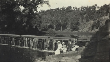
Photograph, Richardson Family at Dight's Falls, 1920
Dight’s Falls in Studley Park is an artificial weir built on a natural rock bar across the Yarra. The weir was built in the 1840s to provide water to the ‘Ceres’ flour-mill, one of the first in Victoria. The falls were later to become known as Dight’s Falls after the owners of the mill. Later, a pumping station was built on the Kew side of the river, which pumped water uphill to a reservoir in Walmer Street that provided water to the Melbourne Botanical Gardens and to Albert Park Lake. The area around Dight’s Falls was and is frequently used for recreational activities.This photograph forms part of the collection assembled by the historian Dorothy Rogers, that was donated to the Kew Historical Society by her son John Rogers in 2015. The manuscripts, photographs, maps, and documents were sourced by her from both family and local collections or produced as references for her print publications. Many were directly used by Rogers in writing ‘Lovely Old Homes of Kew’ (1961) and 'A History of Kew' (1973), or the numerous articles on local history that she produced for suburban newspapers. Most of the photographs in the collection include detailed annotations in her hand. The Rogers Collection provides a comprehensive insight into the working habits of a historian in the 1960s and 1970s. Together it forms the largest privately-donated collection within the archives of the Kew Historical Society.Black and white photograph of the Richardson family seated on the Kew side of Dight's Falls in 1920. One of the girls in the photograph was to become the Melbourne historian Dorothy (Richardson) Rogers.Annotation on reverse: "Mrs D. Rogers, 29 Park Crst Kew. Dights Falls 1920"dight's falls - kew (vic) - fairfield (vic), sport and recreation - kew (vic), dorothy rogers -
Kew Historical Society Inc
Journal, Kewriosity : July 1993
Thank you to the volunteers of Kew / p1. Recreation Centre Extension / p1. Chief Executive's Column [Municipal boundaries] / p2&3. Mayor's Comment / Cr Roger Streeton p3. Diary Dates [July - August 1993] / p4. Main Street comes to Kew / p5. Scholarships bring success to Kew High School / p5. Explore worlds through a book / p5. Council News [Mayor's Winter Concert; Kindergarten open days; Council elections; Davis St Kindergarten; Death cap mushrooms] / p6. Around Kew [Kew Community House; Citizen's Advice Bureau; Working to help mothers; Over 50's water exercises; CAA book fair; New computers for Trinity Grammar] / p7. Weekly collection of mobile garbage tins begins from 19 July / p8.Kewriosity was a local newsletter combining Kew Council and community news. It was published between November 1983 and June 1994, replacing an earlier Kewriosity [broad] Sheet (1979-84). In producing Kewriosity, Council aimed to provide a range of interesting and informative articles covering its deliberations and decision making, together with items of general interest and importance to the Kew community and information not generally available through daily media outlets.non-fictionThank you to the volunteers of Kew / p1. Recreation Centre Extension / p1. Chief Executive's Column [Municipal boundaries] / p2&3. Mayor's Comment / Cr Roger Streeton p3. Diary Dates [July - August 1993] / p4. Main Street comes to Kew / p5. Scholarships bring success to Kew High School / p5. Explore worlds through a book / p5. Council News [Mayor's Winter Concert; Kindergarten open days; Council elections; Davis St Kindergarten; Death cap mushrooms] / p6. Around Kew [Kew Community House; Citizen's Advice Bureau; Working to help mothers; Over 50's water exercises; CAA book fair; New computers for Trinity Grammar] / p7. Weekly collection of mobile garbage tins begins from 19 July / p8.publications -- city of kew (vic.), kewriosity, council newsletters, community newsletters -
 Kew Historical Society Inc
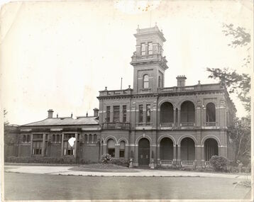
Photograph - 'Raheen', Studley Park Road (Kew), c.1965
"The first section of Raheen was commenced in 1870 with an extension added in 1884. It was designed by William Salway and built for Edward Latham of the Carlton Brewery. Sir Henry Wrixon, prominent Melbourne barrister and solicitor, later owned and resided at the property. In 1917 Raheen was purchased by the Catholic Church and became the official residence of Archbishop Mannix, as well as four other Catholic archbishops of Melbourne. In 1981 the Church sold the property and it again reverted to a private residence." (Victorian Heritage Database, 2023)This work forms part of the collection assembled by the historian Dorothy Rogers (1905-1973), donated to the Kew Historical Society by her son in 2015. The manuscripts, photographs, maps, and documents were sourced by her from both family and local collections or produced as references for her print publications. Many were directly used by Rogers in writing ‘Lovely Old Homes of Kew’ (1961) and 'A History of Kew' (1973), or the numerous articles on local history that she produced for suburban newspapers. Most of the photographs in the collection include detailed annotations in her hand. The Rogers Collection provides a comprehensive insight into the working habits of a historian from the 1960s to the 1970s. Original, monochrome print copy of a photograph of Raheen in Studley Park Road (Kew). The unrendered red brick house with tower has a toe story section at right with a double colonnade and a single story section at left. The photographs predates the restoration of the gardens and house by te. Pratt family. Annotation verso: "Raheen. R. C. Archbishops Palace, Studley Park Road, Kew".reheen, mansions -- kew (vic.), studley park road -
![[Section] Drawing room ceiling , 'Villa Alba', Walmer Street (Kew)](/media/collectors/550653872162f11fb04854aa/items/658d13590f23e8f1e738caea/item-media/658d13c20f23e8f1e738ce30/item-fit-380x285.jpg) Kew Historical Society Inc
Kew Historical Society IncPhotograph - Drawing room ceiling , 'Villa Alba', Walmer Street (Kew), c. 1965
"Villa Alba is of significance for the outstanding late Victorian painted decoration throughout its interior. The consistently high standard of design in the decoration, and high, and at times, superb quality of its execution, the variety of illustrative techniques, the variety of illusionist effects and the hierarchy of treatments between the rooms of the house all contribute to the significance. The decorative scheme is also of significance as a fine example of the work of the leading Melbourne decorators, the Paterson Brothers. It is one of their first interiors to depart totally from the use of pre-prepared wallpapers of repetitive designs and it is a rare and comprehensive extant example of their domestic work. The decorative schemes in the ground floor hall, the dining room, the drawing, the vestibule, the stair hall, the upper hall, bedroom 1 and the boudoir are also individually of significance as outstanding examples of Victorian decoration.." (Victorian Heritage Database, 2023)This work forms part of the collection assembled by the historian Dorothy Rogers (1905-1973), donated to the Kew Historical Society by her son in 2015. The manuscripts, photographs, maps, and documents were sourced by her from both family and local collections or produced as references for her print publications. Many were directly used by Rogers in writing ‘Lovely Old Homes of Kew’ (1961) and 'A History of Kew' (1973), or the numerous articles on local history that she produced for suburban newspapers. Most of the photographs in the collection include detailed annotations in her hand. The Rogers Collection provides a comprehensive insight into the working habits of a historian from the 1960s to the 1970s. Original print monochrome photograph of a section of the drawing room ceiling in 'Villa Alba', Walmer Street (Kew)Annotation on reverse: "Villa Alba ceilings. [Stamp - The Royal Women's Hospital, 212 Cardigan Street, Carlton. With Compliments of Public Relations Office]"dorothy rogers, villa alba museum, paterson bros, interior decoration -- 1880s -
!['Reno', St John's Parade [Kew]](/media/collectors/550653872162f11fb04854aa/items/658d16120f23e8f1e738df53/item-media/658d16680f23e8f1e738e098/item-fit-380x285.jpg) Kew Historical Society Inc
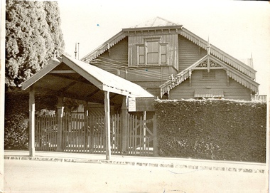
Kew Historical Society IncPhotograph - 'Reno', St John's Parade [Kew], c. 1965
‘Reno’, stood on the east side of St John’s Parade. Its earliest recorded owner was the architect Samuel Cocking who lived there from c.1865 until his death in 1888. The original landholding was bordered by Cotham Road, Glenferrie Road, Wellington Street, and Charles Street. The garden including rare plants supplied by Baron Von Mueller, surrounds the cottage in a tangled frenzy. Despite a ‘local significance’ classification by the National Trust, the house was demolished in 1977.This work forms part of the collection assembled by the historian Dorothy Rogers (1905-1973), donated to the Kew Historical Society by her son in 2015. The manuscripts, photographs, maps, and documents were sourced by her from both family and local collections or produced as references for her print publications. Many were directly used by Rogers in writing ‘Lovely Old Homes of Kew’ (1961) and 'A History of Kew' (1973), or the numerous articles on local history that she produced for suburban newspapers. Most of the photographs in the collection include detailed annotations in her hand. The Rogers Collection provides a comprehensive insight into the working habits of a historian from the 1960s to the 1970s. Original monochrome photograph of Reno, St John's Parade, Kew. Pictured are the garage in the distance at left, the weatherboard house with its simple verandah, and the overgrown front garden.Annotation verso: "Reno. St Johns Parade. Reno. Miss Green".dorothy rogers, reno.-- st john's parade (kew) -
!['Studley House', Nolan Avenue [Kew]](/media/collectors/550653872162f11fb04854aa/items/658d18490f23e8f1e738ec0d/item-media/658d18710f23e8f1e738ecc2/item-fit-380x285.jpg) Kew Historical Society Inc
Kew Historical Society IncPhotograph - 'Studley House', Nolan Avenue [Kew], c. 1965
The first section of Studley House, now part of the preparatory school for Xavier College conducted by the Society of Jesus in Kew, was built in about 1857 for Parliamentarian John Hodgson, an early settler in the district, as a two-storey residence in the Classical Revival style. The name Studley House was first recorded in the Kew ratebooks in 1862, after the house was purchased in 1860 by James McEvoy, squatter. Alterations and an extension, designed by William J Ellis were undertaken in 1875. The house was again altered in 1919 during the ownership of John Wren, former bookmaker, ALP lobbyist, influential Irish-Catholic and millionaire. After 1969 the house was used by the school. (Victorian Heritage Database, 2023)This work forms part of the collection assembled by the historian Dorothy Rogers (1905-1973), donated to the Kew Historical Society by her son in 2015. The manuscripts, photographs, maps, and documents were sourced by her from both family and local collections or produced as references for her print publications. Many were directly used by Rogers in writing ‘Lovely Old Homes of Kew’ (1961) and 'A History of Kew' (1973), or the numerous articles on local history that she produced for suburban newspapers. Most of the photographs in the collection include detailed annotations in her hand. The Rogers Collection provides a comprehensive insight into the working habits of a historian from the 1960s to the 1970s. Original monochrome photograph of Studley House in Nolan Avenue, Kew. The photo shows the entrance flanked by urns and a section of the Nolan Avenue facing rendered and painted colonnade.Annotation verso: "Studley House. Visited by Prince of Wales, Edward VIII. Another view. Front Entrance to Studley house. National Trust".dorothy rogers, studley house -- nolan avenue (kew) -
!['Studley House', Nolan Avenue [Kew]](/media/collectors/550653872162f11fb04854aa/items/658d1a9d0f23e8f1e738f8fa/item-media/658d1ac70f23e8f1e738f9c2/item-fit-380x285.jpg) Kew Historical Society Inc
Kew Historical Society IncPhotograph - 'Studley House', Nolan Avenue [Kew], c. 1965
The first section of Studley House, now part of the preparatory school for Xavier College conducted by the Society of Jesus in Kew, was built in about 1857 for Parliamentarian John Hodgson, an early settler in the district, as a two-storey residence in the Classical Revival style. The name Studley House was first recorded in the Kew ratebooks in 1862, after the house was purchased in 1860 by James McEvoy, squatter. Alterations and an extension, designed by William J Ellis were undertaken in 1875. The house was again altered in 1919 during the ownership of John Wren, former bookmaker, ALP lobbyist, influential Irish-Catholic and millionaire. After 1969 the house was used by the school. (Victorian Heritage Database, 2023)This work forms part of the collection assembled by the historian Dorothy Rogers (1905-1973), donated to the Kew Historical Society by her son in 2015. The manuscripts, photographs, maps, and documents were sourced by her from both family and local collections or produced as references for her print publications. Many were directly used by Rogers in writing ‘Lovely Old Homes of Kew’ (1961) and 'A History of Kew' (1973), or the numerous articles on local history that she produced for suburban newspapers. Most of the photographs in the collection include detailed annotations in her hand. The Rogers Collection provides a comprehensive insight into the working habits of a historian from the 1960s to the 1970s. Original monochrome photograph of the view from the first floor verandah of Studley House in Nolan Avenue, Kew. The photo shows the detail of the cast iron lace work used on this section of the verandah.Annotation verso: "Lovely lacework of the balcony Studley House"dorothy rogers, studley house -- nolan avenue (kew) -
![Victorian era cottage, Derby Street [Kew]](/media/collectors/550653872162f11fb04854aa/items/658f5772101c4283c6ae47ff/item-media/658f57e4101c4283c6ae493a/item-fit-380x285.jpg) Kew Historical Society Inc
Kew Historical Society IncPhotograph - Victorian era cottage, Derby Street [Kew], c. 1965
The current site of the Kew Recreation Centre in High Street Kew previously housed the Kew Depot on the corner of Disraeli Street. In nearby Derby Street, a number of original Victorian era buildings were gradually replaced due to development of the Baths precinct and commercial development.This work forms part of the collection assembled by the historian Dorothy Rogers (1905-1973), donated to the Kew Historical Society by her son in 2015. The manuscripts, photographs, maps, and documents were sourced by her from both family and local collections or produced as references for her print publications. Many were directly used by Rogers in writing ‘Lovely Old Homes of Kew’ (1961) and 'A History of Kew' (1973), or the numerous articles on local history that she produced for suburban newspapers. Most of the photographs in the collection include detailed annotations in her hand. The Rogers Collection provides a comprehensive insight into the working habits of a historian from the 1960s to the 1970s. Small single fronted cottage in Derby Street, Kew. The weatherboard cottage has a block fronted facade, and a Victorian verandah with cast iron lace.Annotation verso: "House in Derby St., next to Kew Baths (Demolished?)"dorothy rogers, derby street (kew), victorian houses -- kew (vic.) -
 Kew Historical Society Inc
Photograph - Kew Recreation Hall, Wellington Street, c.1950
The Kew Recreation Hall was opened in 1880. For eighty years it was a major venue for concerts, performances, dances and civic events. It was demolished in 1960.This work forms part of the collection assembled by the historian Dorothy Rogers (1905-1973), donated to the Kew Historical Society by her son in 2015. The manuscripts, photographs, maps, and documents were sourced by her from both family and local collections or produced as references for her print publications. Many were directly used by Rogers in writing ‘Lovely Old Homes of Kew’ (1961) and 'A History of Kew' (1973), or the numerous articles on local history that she produced for suburban newspapers. Most of the photographs in the collection include detailed annotations in her hand. The Rogers Collection provides a comprehensive insight into the working habits of a historian from the 1960s to the 1970s. Front view, from Wellington Street, of the former Kew Recreation Hall. The 1880 weatherboard building has a long covered entrance leading to the gabled facade. A smaller gabled room protrudes from one side of the facade. At this stage, the decorative features: gables, brackets, finials, etc were still preserved. The triple window would have been a major source of light for the interior. It appears to have an upper balcony in front of the window. Annotation verso: "28. Kew Recreation Hall prior to demolition. Built about 1880."dorothy rogers, kew recreation hall, buildings -- wellington street (kew) -
![Giant Red Gum. Victoria Park [Kew]](/media/collectors/550653872162f11fb04854aa/items/658f5e1a101c4283c6ae8194/item-media/658f5e76101c4283c6ae8404/item-fit-380x285.jpg) Kew Historical Society Inc
Kew Historical Society IncPhotograph - Giant Red Gum. Victoria Park [Kew], c.1950
In 1871, Victoria Park, beside the Boroondara General Cemetery was set aside as a public reserve. As the Park developed, exotic plants were added to existing specimens. In 1910, a photograph of ‘The Oldest Inhabitant: A Giant Red-gum Tree’ in the Park was included in the Jubilee History of Kew. Fifty-one years later the tree was re-photographed by Colin Campbell. A 2007 Master Plan developed for the City of Boroondara advises the retention of this now dead River Red Gum, including a ‘managed risk zone’ and planting under the heavily lopped tree.This work forms part of the collection assembled by the historian Dorothy Rogers (1905-1973), donated to the Kew Historical Society by her son in 2015. The manuscripts, photographs, maps, and documents were sourced by her from both family and local collections or produced as references for her print publications. Many were directly used by Rogers in writing ‘Lovely Old Homes of Kew’ (1961) and 'A History of Kew' (1973), or the numerous articles on local history that she produced for suburban newspapers. Most of the photographs in the collection include detailed annotations in her hand. The Rogers Collection provides a comprehensive insight into the working habits of a historian from the 1960s to the 1970s. Small monochrome snapshot of the former giant River Red Gum that until it died was a major feature of Victoria Park, Kew. In the background is the red brick wall of the Boroondara General (Kew) Cemetery.Annotation verso: "Giant Red Gum. Victoria Park. Still there over 100 yrs old"dorothy rogers, victoria park (kew), river red gums -
!['Ellesmere', Princess Street [Kew]](/media/collectors/550653872162f11fb04854aa/items/658f623d101c4283c6ae94cb/item-media/658f6272101c4283c6ae9580/item-fit-380x285.jpg) Kew Historical Society Inc
Kew Historical Society IncPhotograph - 'Ellesmere', Princess Street [Kew], c.1950
A National Trust (Vic) citation records that Ellesmore [sic] was: 'A late Victorian Villa in the grand manner but completed to a meaner standard in the Edwardian Period. Notable for the mannerist porticos surmounted by a sepulchre motif: the central vestibule at the intersection of the two major axes, with lantern lighting from above: and the art nouveau woodwork of the drawing room'.This work forms part of the collection assembled by the historian Dorothy Rogers (1905-1973), donated to the Kew Historical Society by her son in 2015. The manuscripts, photographs, maps, and documents were sourced by her from both family and local collections or produced as references for her print publications. Many were directly used by Rogers in writing ‘Lovely Old Homes of Kew’ (1961) and 'A History of Kew' (1973), or the numerous articles on local history that she produced for suburban newspapers. Most of the photographs in the collection include detailed annotations in her hand. The Rogers Collection provides a comprehensive insight into the working habits of a historian from the 1960s to the 1970s. Faded monochrome snapshot of 'Ellesmere'Annotation verso: "Porch of Ellesmere"dorothy rogers, ellesmere -- princess street -- kew (vic), houses -- princess street (kew)