Showing 1698 items matching " aerial photographs"
-
 Glenelg Shire Council Cultural Collection
Photograph - Photograph - aerial view of Portland, n.d
... Photograph - aerial view of Portland...Aerial black and white photograph, looking north along Bentinck st from Civic Hall to Water Tower....Photograph Photograph - aerial view of Portland ...Port of Portland AuthorityBack: fd001- pencilport of portland archives, aerial photography, portland harbour -
Glenelg Shire Council Cultural Collection
Photograph - Photograph - Aerial view from the N.W. of Portland Harbour under construction, c. 1950
... Photograph - Aerial view from the N.W. of Portland Harbour under construction...Black and white photograph. Aerial view from the N.W. of Portland Harbour under construction. ...Photograph Photograph - Aerial view from the N.W. of Portland Harbour under construction Unknown ...Port of Portland Authority archives.Front: (no inscriptions) Back: (no inscriptions)port of portland archives -
 Bendigo Military Museum
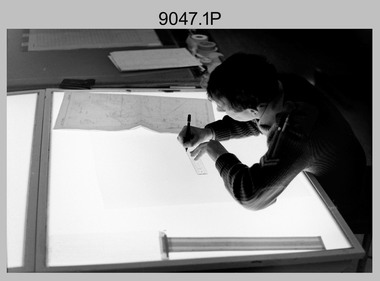
Photograph - Army Survey Regiment – Map Production, Fortuna, Bendigo, Army Survey Regiment – Map Production, Fortuna, Bendigo, c1990
... They are part of the Army Survey Regiment’s Collection. .1) to .3) - Photo, black & white, c1990, CPL Greg Honan transfers map annotations from a field check map sheet to a master compilation sheet using a Rotring Isograph ink pen. .4) - Photo, black & white, c1990, SPR Mick Arnott verifies features in 3D with a Casella stereoscope on an overlapped pair of aerial photographs. .5) - Photo, black & white, c1990, SGT Sherri (Dally) Burke working in the AUTOMAP 2 system. ...They are part of the Army Survey Regiment’s Collection. .1) to .3) - Photo, black & white, c1990, CPL Greg Honan transfers map annotations from a field check map sheet to a master compilation sheet using a Rotring Isograph ink pen. .4) - Photo, black & white, c1990, SPR Mick Arnott verifies features in 3D with a Casella stereoscope on an overlapped pair of aerial photographs. .5) - Photo, black & white, c1990, SGT Sherri (Dally) Burke working in the AUTOMAP 2 system. ...This is a set of five photograph of technicians performing map production tasks at the Army Survey Regiment, Fortuna, Bendigo, circa 1990. Photos .1P to .4P were taken either in Air Survey Squadron or Cartographic Squadron.This is a set of five photograph of Map Production performed at the Army Survey Regiment, Fortuna, Bendigo, c1990. The photographs are on 35mm negative film and scanned at 96 dpi. They are part of the Army Survey Regiment’s Collection. .1) to .3) - Photo, black & white, c1990, CPL Greg Honan transfers map annotations from a field check map sheet to a master compilation sheet using a Rotring Isograph ink pen. .4) - Photo, black & white, c1990, SPR Mick Arnott verifies features in 3D with a Casella stereoscope on an overlapped pair of aerial photographs. .5) - Photo, black & white, c1990, SGT Sherri (Dally) Burke working in the AUTOMAP 2 system. .1P to .5P – There are no annotationsroyal australian survey corps, rasvy, fortuna, army survey regiment, automap 2 -
 Alfred Hospital Nurses League - Nursing History Collection
Magazine - Illustrated magazine, Alfred Hospital, 'The Alfred' Official Journal of the Alfred Hospital Melbourne, Victoria, 1940
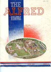
... Magazine has a white cover on the front is an oval shaped coloured aerial photograph of the Alfred Hopital [ca.1940] there is also a wide blue vertical stripe on which the title is printed in red blue and white ink. ...Included are a list of Alfred Hospital Board members, hospital auxillaries news, PTS nusres in March and May 1940, Grace Wilson resignation, Hospitals yesterday and today previous catalogue number handwritten in black ink at top right of front cover Magazine has a white cover on the front is an oval shaped coloured aerial photograph of the Alfred Hopital [ca.1940] there is also a wide blue vertical stripe on which the title is printed in red blue and white ink. ...magazine with various articles and advertisements. Included are a list of Alfred Hospital Board members, hospital auxillaries news, PTS nusres in March and May 1940, Grace Wilson resignation, Hospitals yesterday and todayMagazine has a white cover on the front is an oval shaped coloured aerial photograph of the Alfred Hopital [ca.1940] there is also a wide blue vertical stripe on which the title is printed in red blue and white ink. At the bottom of the front cover are 4 narrow horizontal stripes (red,blue, white and blue) On the white stipe the words 'published quarterly June 1940 price 3d" are printed in red. On the back cover is a blue and white photograph of a two story building (Hamilton Russell House [ca.1940] ) Along with an advertisement for Hamilton Russell House in red and blue print. Abreviated title at top right, and printer's details at bottom in blue printnon-fictionmagazine with various articles and advertisements. Included are a list of Alfred Hospital Board members, hospital auxillaries news, PTS nusres in March and May 1940, Grace Wilson resignation, Hospitals yesterday and todayalfred hospital, alfred hospital auxilleries -
 Alfred Hospital Nurses League - Nursing History Collection
Magazine - Illustrated magazine, The Alfred Hospital, 'The Alfred' Official Journal of the Alfred Hospital Melbourne, Victoria, 1940
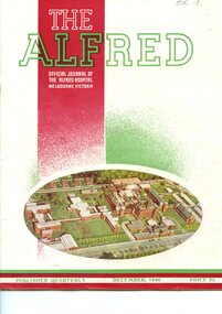
... Magazine has a white cover on the front is an oval shaped coloured aerial photograph of the Alfred Hopital [ca.1940] there is also a wide red vertical stripe on which the title is printed in red, greenand white ink. ...Alfred Hospital Nurses League - Nursing History Collection Ground Floor, Building 10 Caulfield Hospital 260 Kooyong Road Caulfield melbourne Of significance to the AHNl as it is a magazine of the Alfred Hospital Alfred Hospital Alfred Hospital Auxilleries contains news of the activities and development of the Alfred Hospital and the work of the Alfred Hospital Auxillary, list of nurses September & NovemberPTS (Preliminary Training Schoo), cooking hints miscellaneous articles and advertisements Previous catalogue number is handwritten in black ink at top right of front cover Magazine has a white cover on the front is an oval shaped coloured aerial photograph of the Alfred Hopital [ca.1940] there is also a wide red vertical stripe on which the title is printed in red, greenand white ink. ...contains news of the activities and development of the Alfred Hospital and the work of the Alfred Hospital Auxillary, list of nurses September & NovemberPTS (Preliminary Training Schoo), cooking hints miscellaneous articles and advertisementsMagazine has a white cover on the front is an oval shaped coloured aerial photograph of the Alfred Hopital [ca.1940] there is also a wide red vertical stripe on which the title is printed in red, greenand white ink. At the bottom of the front cover are 4 narrow horizontal stripes (green, red, white and red) On the white stipe the words 'published quarterly December 1940 price 3d" are printed in green. On the back cover is a red and white photograph of a two story building (Hamilton Russell House [ca.1940] ) Along with an advertisement for Hamilton Russell House in red and green print. Abreviated title at top right, and printer's details at bottom in red printnon-fictioncontains news of the activities and development of the Alfred Hospital and the work of the Alfred Hospital Auxillary, list of nurses September & NovemberPTS (Preliminary Training Schoo), cooking hints miscellaneous articles and advertisementsalfred hospital, alfred hospital auxilleries -
 Phillip Island and District Historical Society Inc.
Photograph - Post Card, 1954
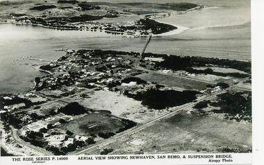
... Black & White photograph of aerial view over water and land. Newhaven in foreground and San Remo at rear of suspension bridge....Black & White photograph of aerial view over water and land. Newhaven in foreground and San Remo at rear of suspension bridge. ...One of a collection of photographs donated by Daryl JohnsBlack & White photograph of aerial view over water and land. Newhaven in foreground and San Remo at rear of suspension bridge."The Rose Series P.14000. Aerial view showing Newhaven, San Remo & Suspension Bridge." Airspy Photo.phillip island, newhaven, san remo, daryl johns -
 NMIT (Northern Melbourne Institute of TAFE)
Photographs: PTS Admin Building c1940s aerial view, Photographs: Preston Technical School Administration Building c1940s aerial view
... Two black and white photographs of aerial view of Building A (Administration Building) Preston campus of Preston Technical School c1940s. ...Photographs: Preston Technical School Administration Building c1940s aerial view Photographs: PTS Admin Building c1940s aerial view ...Two black and white photographs of aerial view of Building A (Administration Building) Preston campus of Preston Technical School c1940s. preston technical school, buildings, nmit -
Glenelg Shire Council Cultural Collection
Photograph, c. 1967
... Unframed aerial black and white photograph, taken from the S.W. Henty Park, Botanical gardens and construction of no. 6 berth....Port of Portland Henty Park Portland Botanic Gardens Back: Aerial view of section of Port and its surrounds Unframed aerial black and white photograph, taken from the S.W. Henty Park, Botanical gardens and construction of no. 6 berth. ...Port of Portland Authority archives On 19 November 1960, the Portland Harbour Trust was officially opened by His Excellency, The Governor of Victoria, Sir Dallas Brooks, in front of thousands of onlookers. It was one of the largest concentration of Premiers, Statesmen, industrial and civic leaders ever to attend an event outside of an Australian capital city. Today, Port of Portland is a busy modern port, handling in excess of $2 billion in trade. One of Victoria’s four major shipping ports, it handles bulk cargoes such as plantation woodchips and logs, grain, aluminium products, mineral sands, fertiliser, livestock and wind tower components.This forms part of the archives of the Port of Portland which were donated to the Glenelg Shire Cultural Collection by the Port of Portland. The collection documents the growth and significance of the Port of Portland.Back: Aerial view of section of Port and its surroundsport of portland, henty park, portland botanic gardens -
Port Melbourne Historical & Preservation Society
Photograph - Photograph board, Seven aerial views of J Kitchen & Sons site, Port Melbourne, J Kitchen & Sons Pty Ltd. Port Melbourne 1951, 1951
... Photograph board, Seven aerial views of J Kitchen & Sons site, Port Melbourne...Large brown cardboard with seven (7) B&W aerial photographs pasted on it. Taken in 1951. ...Port Melbourne 1951 Photograph Photograph board, Seven aerial views of J Kitchen & Sons site, Port Melbourne ...Large brown cardboard with seven (7) B&W aerial photographs pasted on it. Taken in 1951. Photo 1 - South East direction with Boundary Street in foreground, Kitchens buildings and Football Ground (cricket being played) Photo 2 - South West direction towards the Bay showing Station and Princes Piers, with ships in the distance. Photo 3 - almost directly above Kitchens Photo 4 - directly above kitchens Photo 5 - looking West including the Yarra River Photo 6 - looking North with Kitchen's storage and football ground in foreground Photo 7 - looking north east with football ground in foregrpound left and Yarra River top right.industry - manufacturing, built environment - industrial, piers and wharves - princes pier, piers and wharves - station pier, sport - australian rules football, sport - cricket, sport - recreational grounds, j kitchen & sons pty ltd, north port oval, port melbourne cricket ground -
 Ringwood and District Historical Society
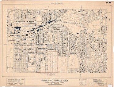
Map - State Aerial Survey, Dandenong Ranges Area, Parishes of Warrandyte and Ringwood - 1956
... Map of central and southern areas of Ringwood and part of Ringwood East and Heathmont compiled by Dept of Lands and Survey, July 1956, from aerial photographs and Cadastral Survey information. ...Map of central and southern areas of Ringwood and part of Ringwood East and Heathmont compiled by Dept of Lands and Survey, July 1956, from aerial photographs and Cadastral Survey information. ...Map of central and southern areas of Ringwood and part of Ringwood East and Heathmont compiled by Dept of Lands and Survey, July 1956, from aerial photographs and Cadastral Survey information. Subsequent hand-drawn addition of streets showing layout of "Township of Ballyduffy Estate 1858-60", an earlier proposed subdivision that did not eventuate. (See attached 5009b Ballyshanassy_ Melbourne’s lost suburb.pdf for Ballyduffy historical naming relevance). Ballyduffy Estate streets include City Road, West Prussia Road, Duffy Street, Ireland Street, Evans Street, Victoria Street, Regina Street, Short Road, Prussia Road, Duffy Street East, Ireland Street East, Evans Street East, Chapman Street. Misc Topo 93 Sheet 22, Ringwood A4B2. Scale: 4 chains to 1 inch. Contour interval 20 feet. -
Glenelg Shire Council Cultural Collection
Photograph - Photograph - aerial view of Port of Portland, c. 1974
... Photograph - aerial view of Port of Portland...Black and white photograph, aerial view taken from the north. View of Port of Portland, livestock carrier berthed at K.S. ...Photograph Photograph - aerial view of Port of Portland Unknown ...Port of Portland Authority archives.Front: (no inscriptions) Back: (no inscriptions)port of portland archives, aerial photography, portland harbour, k s anderson wharf, s l patterson wharf -
 8th/13th Victorian Mounted Rifles Regimental Collection
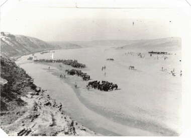
Photograph - 8th LH in desert
... Aerial black and white photograph of light horse regiment in desert. ...The 8th Light Horse AIF was disbanded in 1919, but soon after re-raised as the 8th (Indi) Light Horse in the Citizen Military Forces, superseding 16th (Indi) Light Horse. 8th light horse world war one wwi middle east Aerial black and white photograph of light horse regiment in desert. ...The 8th Light Horse Regiment AIF was raised at Broadmeadows Victoria in September 1914 under the command of Lieutenant Colonel Alexander White and formed part of the 3rd Light Horse Brigade. The regiment served at Gallipoli where in a courageous but ill-fated charge at the Nek on 7 August 1915 it suffered horrendous casualties including Lieutenant Colonel White. Rebuilt in Egypt under the command of Lieutenant Colonel Leslie Maygar VC the regiment went on the serve throughout the Middle East Campaign. Colonel Maygar died of wounds at Beersheba when the regiment was attacked by enemy aircraft while waiting to follow up the successful charge of the 4th LH Brigade on 30 October 1917. The 8th Light Horse AIF was disbanded in 1919, but soon after re-raised as the 8th (Indi) Light Horse in the Citizen Military Forces, superseding 16th (Indi) Light Horse. Aerial black and white photograph of light horse regiment in desert. Thought to be 8th Australian Light Horse (AIF) c.1917.8th, light horse, world war one, wwi, middle east -
 Bayside Gallery - Bayside City Council Art & Heritage Collection
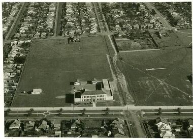
Photograph - gelatin silver photograph, H. Singer, Elsternwick Park Committee of Management 1935-36, 1936
... One larger rectangular aerial photograph of Elsternwick Park surrounded by seven smaller rectangular landscape photographs of buildings or sites and eight oval portrait photographs of Elsternwick Park Committee of Management. ...One larger rectangular aerial photograph of Elsternwick Park surrounded by seven smaller rectangular landscape photographs of buildings or sites and eight oval portrait photographs of Elsternwick Park Committee of Management. ...elsternwick park, tennis, football, hockey, playground, sports pavilion, club, ralph tyner, l.l. chapman, cr. g.a. giles, cr. eustace tracey, cr. j.a. kennedy, chairman, cricket, c.e. tuxen, engineer, j.h. taylor, town clerk, treasurer, c.j. pollock, councillor, aerial view, golf, croquet, club house -
Kew Historical Society Inc
Booklet - Old Kew Golf Links Estate, 1926
... The brochure is notable as it includes photographs of Kew East Primary School, the former Kew Golf Club clubhouse, and 'The Moorings' Boathouse (aka Chipperfield's Boat House). The aerial photograph, overlaid with names of notable sites, on the final page is of interest as it shows the area before the intrusion of the Eastern Freeway, which resulted in changing the course of a section of the Yarra River. ...The brochure is notable as it includes photographs of Kew East Primary School, the former Kew Golf Club clubhouse, and 'The Moorings' Boathouse (aka Chipperfield's Boat House). The aerial photograph, overlaid with names of notable sites, on the final page is of interest as it shows the area before the intrusion of the Eastern Freeway, which resulted in changing the course of a section of the Yarra River. ...Subdivision plans and real estate flyers/brochures reveal a number of aspects of urban development and history. The Kew Historical Society's collection of these plans, as well as advertisements extracted from magazines, cover key aspects of community development and architectural history of Kew and Kew Eat as well as surrounding suburbs. While most of the plans in the collection were gifted to the Society by the former City of Kew, a number of other plans and advertisements have been donated by individuals, of which this is an example.8-page brochure advertising 80 residential home sites for sale in a subdivision called the 'Old Kew Golf Links Estate'. These sites had historic importance in Kew's history as they had previously belonged to Kodak Pty Ltd who were refused permission by Kew Council to use the land for industrial development. The estate, advertised was advertised as being within five miles of Melbourne. The brochure is notable as it includes photographs of Kew East Primary School, the former Kew Golf Club clubhouse, and 'The Moorings' Boathouse (aka Chipperfield's Boat House). The aerial photograph, overlaid with names of notable sites, on the final page is of interest as it shows the area before the intrusion of the Eastern Freeway, which resulted in changing the course of a section of the Yarra River. old kew golf links estate, subdivision -- kew (vic.), subdivisions -- kew east (vic), chipperfield's boathouse, kew east primary school, kew golf club -
Glenelg Shire Council Cultural Collection
Photograph - Photograph - Aerial view of the Port of Portland from the south-west, c. 1967
... Photograph - Aerial view of the Port of Portland from the south-west...Unframed aerial black and white photograph taken from the S.W. K.S.Anderson wharf, silos and reclaimed land prepared for further development of silos....Photograph Photograph - Aerial view of the Port of Portland from the south-west Unknown ...Port of Portland Authority archives.Front: (no inscriptions) Back: Area available for silo extension and storageport of portland archives -
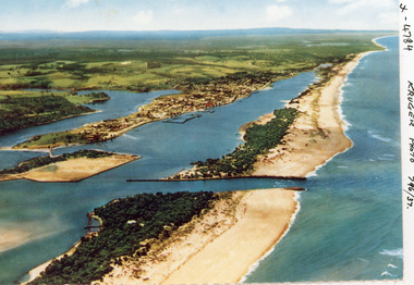 Lakes Entrance Historical Society
Photograph - Lakes Entrance, Kruger A F, 1960c
... Aerial Photograph...Colour photograph aerial view of the entrance from Bass Strait to the Gippsland Lakes, Australia. ...Lakes Entrance Historical Society 4 Marine Parade Lakes Entrance gippsland Aerial Photograph Islands Waterways Topography Township Colour photograph aerial view of the entrance from Bass Strait to the Gippsland Lakes, Australia. ...Colour photograph aerial view of the entrance from Bass Strait to the Gippsland Lakes, Australia. Shows extension to Bullock Island, town of Lakes Entrance, Cunninghame Arm and North Arm. Lakes Entrance Victoriaaerial photograph, islands, waterways, topography, township -
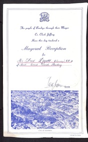 Bendigo Historical Society Inc.
Certificate - IAN DYETT COLLECTION: Fred Dyett Mayoral Reception Certificate
... Underneath there is a blue tinted aerial photograph of Bendig showing Rosalind Park, Post Office, Law Courts, Pall Mall, View St. ...Underneath there is a blue tinted aerial photograph of Bendig showing Rosalind Park, Post Office, Law Courts, Pall Mall, View St. ...Ian Dyett Collection: Fred Dyett Mayoral Reception Certificate a foolscap size cream coloured paper with blue print. A City of Bendigo Coat of Arms at centre top, underneath in cursive script- The people of Bendigo through their Mayor Cr. Clark Jeffery Have this day tendered a Mayoral Reception for (hand written in blue ink and underlined in red) Mr Fred Dyer [Bendigo] V.F.3 of Aust. Coast Guard Auxilary Signed JCM Jeffery MAYOR next to a City of Bendigo Coat of Arms impress into the paper. Underneath there is a blue tinted aerial photograph of Bendig showing Rosalind Park, Post Office, Law Courts, Pall Mall, View St. CITY OF BENDIGO underneath. Cambridge Press Bendigo (in the lower right corner) fred dyett, clark jeffery, australian coast guard auxilary, bendigo -
University of Melbourne, Burnley Campus Archives
Book (item) - Register, Orchard, 1955-1959
... Other inserted roneo charts Blooming Dates Week Ending. 2 Original undated newspaper cuttings "A New Apple- Appears in Tasmania," and "Outstanding Fig Raised at Preston." Aerial photograph of Burnley Gardens and surrounds B92.562....Other inserted roneo charts Blooming Dates Week Ending. 2 Original undated newspaper cuttings "A New Apple- Appears in Tasmania," and "Outstanding Fig Raised at Preston." Aerial photograph of Burnley Gardens and surrounds B92.562. ...ORCHARD on name sticker on front page. Brand of folio - No. 01310H Norman Bros. Pty. Ltd. 60-62 Elizabeth St., Melbourneorchard, field station, history, fruit tree blocks, planting plans, newspaper cutting, red delicious apple, preston prolific fig -
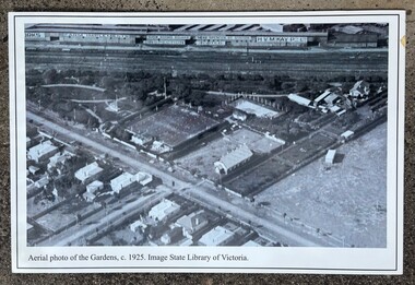 Sunshine and District Historical Society Incorporated
Photograph - Sunshine Gardens Display Photographs
... 4931.01 - Sunshine Gardens Display Photographs - Aerial Photograph Of The Gardens C1927 4931.02 - Sunshine Gardens Display Photographs - Bandstand C1917 4931.03 - Sunshine Gardens Display Photographs - Foral Arch And Seated Figure 4931.04 - Sunshine Gardens Display Photographs - Verna Temple & Betty Deeble C1950 4931.05 - Sunshine Gardens Display Photographs - Stone Lions 1937 4931.06 - Sunshine Gardens Display Photographs - Conservatory 4931.07 - Sunshine Gardens Display Photographs - Palm Trees 4931.08 - Sunshine Gardens Display Photographs - Garden Paths And Rock Walls 4931.09 - Sunshine Gardens Display Photographs - Harold Grey Curator 1930 To 1950 C1947 4931.10 - Sunshine Gardens Display Photographs - Bowling Club 4931.11 - Sunshine Gardens Display Photographs - Bowling Green 1915 4931.12 - Sunshine Gardens Display Photographs - Tennis Courts 4931.13 - Sunshine Gardens Display Photographs - Tennis Club...4931.01 - Sunshine Gardens Display Photographs - Aerial Photograph Of The Gardens C1927 4931.02 - Sunshine Gardens Display Photographs - Bandstand C1917 4931.03 - Sunshine Gardens Display Photographs - Foral Arch And Seated Figure 4931.04 - Sunshine Gardens Display Photographs - Verna Temple & Betty Deeble C1950 4931.05 - Sunshine Gardens Display Photographs - Stone Lions 1937 4931.06 - Sunshine Gardens Display Photographs - Conservatory 4931.07 - Sunshine Gardens Display Photographs - Palm Trees 4931.08 - Sunshine Gardens Display Photographs - Garden Paths And Rock Walls 4931.09 - Sunshine Gardens Display Photographs - Harold Grey Curator 1930 To 1950 C1947 4931.10 - Sunshine Gardens Display Photographs - Bowling Club 4931.11 - Sunshine Gardens Display Photographs - Bowling Green 1915 4931.12 - Sunshine Gardens Display Photographs - Tennis Courts 4931.13 - Sunshine Gardens Display Photographs - Tennis Club Collection of 13 large format black & white photographs mounted on card Photograph Sunshine Gardens Display Photographs ...4931.01 - Sunshine Gardens Display Photographs - Aerial Photograph Of The Gardens C1927 4931.02 - Sunshine Gardens Display Photographs - Bandstand C1917 4931.03 - Sunshine Gardens Display Photographs - Foral Arch And Seated Figure 4931.04 - Sunshine Gardens Display Photographs - Verna Temple & Betty Deeble C1950 4931.05 - Sunshine Gardens Display Photographs - Stone Lions 1937 4931.06 - Sunshine Gardens Display Photographs - Conservatory 4931.07 - Sunshine Gardens Display Photographs - Palm Trees 4931.08 - Sunshine Gardens Display Photographs - Garden Paths And Rock Walls 4931.09 - Sunshine Gardens Display Photographs - Harold Grey Curator 1930 To 1950 C1947 4931.10 - Sunshine Gardens Display Photographs - Bowling Club 4931.11 - Sunshine Gardens Display Photographs - Bowling Green 1915 4931.12 - Sunshine Gardens Display Photographs - Tennis Courts 4931.13 - Sunshine Gardens Display Photographs - Tennis Club -
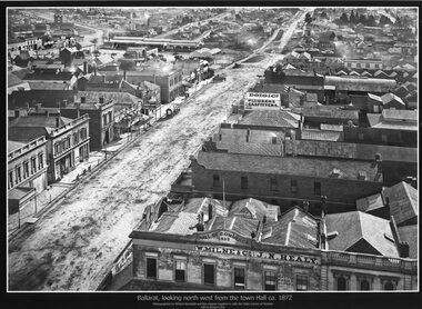 Ballarat Tramway Museum
Photograph - Black & White copy, William Bardell, "Ballarat looking north west from the Town Hall ca 1872"
... Black & White copy photograph aerial view A4 size, titled ""Ballarat looking north west from the Town Hall ca 1872" looking along Armstrong St. ...Ballarat Armstrong St W Milne & Co Doig&Co J N Healy Black & White copy photograph aerial view A4 size, titled ""Ballarat looking north west from the Town Hall ca 1872" looking along Armstrong St. ...Original photograph by William Bardwell, with the original image held by the State Library of Victoria. Edited by Richard Conn. Purchased by the Museum.Provides information about the appearance of Armstrong St from the Town Hall. Shows the topography of the area, along with many buildings, including W Milne & Cp and J N Healy in the Hall of Commerce and Doig & Co, Plumbers and Gasfitters.Black & White copy photograph aerial view A4 size, titled ""Ballarat looking north west from the Town Hall ca 1872" looking along Armstrong St. Original photo by William Bardwell.ballarat, armstrong st, w milne & co, doig&co, j n healy -
Glenelg Shire Council Cultural Collection
Photograph - Photograph - view of Portland and foreshore, 21/03/1972
... Black and white photograph, unframed. Aerial view from west Portland CBD and Portland Harbour reclamation from north west corner of harbour....Port of Portland Archives aerial view of Portland Front: (no inscriptions) Back: 21/3/1972 Black and white photograph, unframed. ...Port of Portland Authority archives.Front: (no inscriptions) Back: 21/3/1972port of portland archives, aerial view of portland -
Glenelg Shire Council Cultural Collection
Photograph - Photograph - View of Portland and foreshore, 21/03/1972
... Unframed aerial black and white photograph from W of Portland. CBD, foreshore and harbour. ...Port of Portland Archives Front: (no inscriptions) Back: (no inscriptions) Unframed aerial black and white photograph from W of Portland. CBD, foreshore and harbour. ...Port of Portland Authority archives.Front: (no inscriptions) Back: (no inscriptions)port of portland archives -
 University of Melbourne, Burnley Campus Archives
Photograph - Black and white print, Aerial View of Burnley Campus c.1965, c. 1965
... Black and white photograph. Enlarged photograph of aerial view of Burnley College encompassed by the Yarra River and showing the surrounding suburban areas. ...University of Melbourne, Burnley Campus Archives 500 Yarra Boulevard Richmond melbourne aerial view burnley college yarra river Black and white photograph. Enlarged photograph of aerial view of Burnley College encompassed by the Yarra River and showing the surrounding suburban areas. ...Black and white photograph. Enlarged photograph of aerial view of Burnley College encompassed by the Yarra River and showing the surrounding suburban areas. Mounted on cardboard.aerial view, burnley college, yarra river -
Glen Eira Historical Society
Document - GLEN HUNTLY
... It includes 1 black and white photograph (52mm x 375mm) of shops along Koornang Road and 1 black and white photograph (52mm x 375mm) of shops along Glen Huntly Road. 3/1 black and white aerial photograph (undated and unattributed) (164mm x 272mm) of Glen Huntly Park Estate and surrounding area, with street names added, which indicates the second section of the Estate for sale....It includes 1 black and white photograph (52mm x 375mm) of shops along Koornang Road and 1 black and white photograph (52mm x 375mm) of shops along Glen Huntly Road. 3/1 black and white aerial photograph (undated and unattributed) (164mm x 272mm) of Glen Huntly Park Estate and surrounding area, with street names added, which indicates the second section of the Estate for sale. ...This file contains 3 items about land subdivision and development in Glen Huntly: 1/1 colour real estate advertisement (undated) for the auction of lots of land in Glen Huntly Park Estate, Glen Huntly to be held 06/12/1930. The poster includes1 black and white photograph (85mm x 201mm) of the Shopping Centre on Glen Huntly Road and a colour map (95mm x 107mm) of the Estate and surrounding locality. Also included on the poster is 1 black and white photograph of the Glen Huntly Park Estate and Cypress Plantation of the Glen Huntly Park. 2/1 undated advertisement for an auction of land in Glen Huntly Park to be held 19/03/1938 pursuant to an order to an order for sale made by the Supreme Court of Victoria. It includes 1 black and white photograph (52mm x 375mm) of shops along Koornang Road and 1 black and white photograph (52mm x 375mm) of shops along Glen Huntly Road. 3/1 black and white aerial photograph (undated and unattributed) (164mm x 272mm) of Glen Huntly Park Estate and surrounding area, with street names added, which indicates the second section of the Estate for sale.glen huntly, grange road, glen huntly road, watson crescent, garden avenue, wattle avenue, park avenue, mckay avenue, neville street, miller street, morgan street, truganini road, koornang road, glen huntly park and recreation reserve, glen huntly park estate, royal avenue, glen huntly railway station, tram depots, lyons street, moira avenue, katandra road, ormond, mimosa road, glen huntly park pty ltd, city of caulfield, lord h, land sales, auctions, parks and reserves, shops, elsternwick, caulfield -
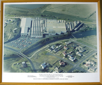 Warrnambool and District Historical Society Inc.
Photograph - Framed aerial photograph of Warrnambool Woollen Mill, Circa 1970
... Framed aerial photograph of Warrnambool Woollen Mill...Aerial colour photograph of the Warrnambool Woollen Mill and surrounding area including carparks. ...Timber frame Photograph Framed aerial photograph of Warrnambool Woollen Mill ...In 1869, the Warrnambool Meat Preserving Company commenced their business on the site, where it operated until 1875 when it was sold to the directors of the Warrnambool Woollen Mill Company. After being destroyed by fire in 1882 it wasn’t until 1910 that the Warrnambool Chamber of Commerce was approached by Marcus Saltau and Peter McGennan to invest in a new mill. The original directors were James Dickson, P J McGennan, Robert Swinton, M Saltau, and J W Younger. In 1955 the Warrnambool Woollen Mill formed a partnership with the Wangaratta Woollen Mills. Dunlop bought the mill in 1968. From that time until its closure in 2000 it had a number of different owners, the last being the Smith Family Industries. The Mill site holds significance for Warrnambool as the site was one of the earliest industries established in the town. The Warrnambool Woollen Mill operated for close to 100 years and in that time forged a strong link with the people of Warrnambool. Its product held a significant position in the marketplace.Aerial colour photograph of the Warrnambool Woollen Mill and surrounding area including carparks. The Merri River crosses from lower left to upper right. Playing field, Jetty Flat, in upper right hand corner and Harris Street bridge in lower left. Aspect is looking easterly. Photo glued to white card mount with text in black underneath. Timber frameWarrnambool Woollen Mill A division of Dunlop Olympic Limited. Manufacturers of Warrnambool/Dreamspun blankets, rugs and fabrics. Registered office South Warrnambool, Victoria. 3280. Australia. P.O. Box 484 Telephone (055)624166. Telex 55820warrnambool, warrnambool woollen mill, woollen mill, dunlop olympic, marcus saltau, p j mcgennan, james dickson, robert swinton, j w younger, dreamspun -
City of Kingston
Photograph - Colour, 1993
... Laminated aerial colour photograph of Carrum and Patterson Lakes in the City of Kingston. ...Patterson Lakes Seaford Carrum Carrum Swamp Black type on white adhesive sticker: No. 7140 Black type of white adhesive sticker: 31-1-93 Black handwritten ink (marker): * [an asterisk] Yellow circular adhesive sticker Laminated aerial colour photograph of Carrum and Patterson Lakes in the City of Kingston. ...Carrum is a suburb in the City of Kingston bordered by the Patterson River in the north and Kananook Creek in the south. To the east the suburb is adjacent to Patterson Lakes. The Carrum Station was opened in 1882, when the railway line from Mordialloc was extended to Frankston. In the early 20th century, it was a destination for holidaymakers occupying tents and cabins. The area now consists of older housing and over time there have been many new housing developments.Carrum is located in the area that was originally part of the Carrum Carrum Swamp. The district had originally been the home of the Bunerong people who fished, gathered food and found refuge in the sand dunes. The Swamp was drained in 1879 when the Patterson Cut was formed and became known as Patterson River. Apart from local farmers, fishermen and hotel-keepers, there were few permanent residents until the early 20th century when it had become popular as a beach resort. In the 1920s and 1930s the area became occupied by more permanent residents.Laminated aerial colour photograph of Carrum and Patterson Lakes in the City of Kingston. The photograph also includes Kananook Creek and the northern section of Seaford. Prominent features include Roy Dore Reserve, Carrum Primary School, Patterson River Secondary College, Keast Park Seaford, the Seaford Swamp Drain and a section of Downs Estate situated on the traditional lands of the Bunurong people.Black type on white adhesive sticker: No. 7140 Black type of white adhesive sticker: 31-1-93 Black handwritten ink (marker): * [an asterisk] Yellow circular adhesive stickerpatterson lakes, seaford, carrum carrum swamp -
Glenelg Shire Council Cultural Collection
Photograph - Photograph - Aerial black and white photograph of Portland harbour and foreshore taken from the N.E. Cape Nelson in background, 07/07/1968
... Photograph - Aerial black and white photograph of Portland harbour and foreshore taken from the N.E. ...Unframed aerial black and white photograph taken from the N.E. Cape Nelson in background. ...Photograph Photograph - Aerial black and white photograph of Portland harbour and foreshore taken from the N.E. ...Port of Portland Authority archivesFront: (no inscriptions) Back: 'Port area with Cape Nelson in background 7/7/1968 (at 800 feet) Harbour basin with 600ft entrance between breakwaters.port of portland archives, cape nelson, no6 berth construction, ocean pier -
Glenelg Shire Council Cultural Collection
Photograph - Photograph - Aerial black and white photograph of Portland Harbour and foreshore taken from the N.E. Cape Nelson in background, 07/07/1968
... Photograph - Aerial black and white photograph of Portland Harbour and foreshore taken from the N.E. ...Unframed aerial black and white photograph taken from the N.E. Cape Nelson in background. ...Photograph Photograph - Aerial black and white photograph of Portland Harbour and foreshore taken from the N.E. ...Port of Portland Authority archivesFront: (no inscriptions) Back: 'Port area with Cape Nelson in background 7/7/1968 (at 800 feet) Harbour basin with 600ft entrance between breakwaters.port of portland archives, cape nelson -
Glenelg Shire Council Cultural Collection
Photograph - Photograph - Aerial view from NE Portland Harbour, c. 1967
... Photograph - Aerial view from NE Portland Harbour...Black and white photograph unframed; aerial view from NE Portland Harbour; no. 6 berth under construction. ...Ocean Railway Pier still in existence Photograph Photograph - Aerial view from NE Portland Harbour ...Port of Portland Authority ArchivesFront: 19 JUN 1997 Back: 19 JUN 1997port of portland archives, ocean railway pier, portland harbour -
Glenelg Shire Council Cultural Collection
Photograph - Photograph - aerial view of Portland Hanrbour, n.d
... Photograph - aerial view of Portland Hanrbour...Aerial black and white photograph showing construction of No.6 berth with a ship berthed. ...Photograph Photograph - aerial view of Portland Hanrbour ...Port of Portland AuthorityBack: Reduce to 52cms wide and 30cms deep - pencil ruled pencil border.port of portland archives, aerial photography, portland harbour