Showing 5521 items
matching centrals
-
 Eltham District Historical Society Inc
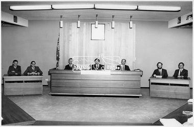
Photograph, View of Council Chamber of Shire of Eltham, 1971
Shire of Eltham Council Members at time of Centenary Celebrations. Left to Right: Cr. J.V. McConnell (Central), Cr. P. Graham (West), Cr. A. Glover (West), Cr. Mrs. Chariw .M. Pelling (North), Cr. B. Taylor (Central), Cr. G.C. Dreverman (President) (Central), Cr. Les E. Clarke (West), Cr. E.A. Hale (North), Cr. J.O. White (North). This photo forms part of a collection of photographs gathered by the Shire of Eltham for their centenary project book, "Pioneers and Painters: 100 years of the Shire of Eltham" by Alan Marshall (1971). The collection of over 500 images is held in partnership between Eltham District Historical Society and Yarra Plenty Regional Library (Eltham Library) and is now formally known as 'The Shire of Eltham Pioneers Photograph Collection.' It is significant in being the first community sourced collection representing the places and people of the Shire's first one hundred years.Digital imagesepp, shire of eltham pioneers photograph collection, shire of eltham, shire of eltham centenary, a.j. roberts, c.j. gaudion, council chambers, cr. g.c. dreverman, g.e. newton, j.a. mcdonald, m.a. verhoeven, m.b. watson, councilors, officers, municipal -
 Bendigo Historical Society Inc.
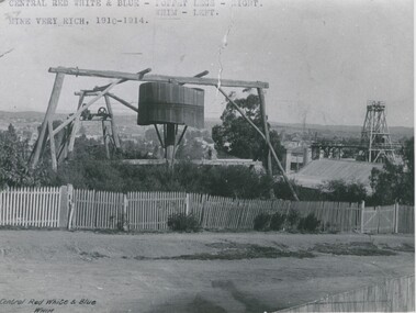
Photograph - EADIES WHIM AT CENTRAL RED WHITE AND BLUE MINE
Black and white copy of Whim at Central Red White and Blue Mine. Whim in foreground, poppet head to right of picture. Picket fence full length of photograph. Corrugated iron roof in foreground. Inscriptions: Front - Central red, white and blue Whim in black, bottom L corner. Front - typewritten - 'Central Red, White and Blue - poppet legs right. Mine very rich. 1910-14' across front top of photo. On back- blue circular stamp 'Royal Historical Society of Victoria, Bendigo Branch. 'MNG 20' 3 copies black ink. History of object: Eadies Whim and the Central Red White and Blue Mine taken from Lilac Street between Old Violet and Honeysuckle Street, Bendigo. (Bendigo Historical Society Inc.)topic, mining -
 Parks Victoria - Gabo Island Lightstation
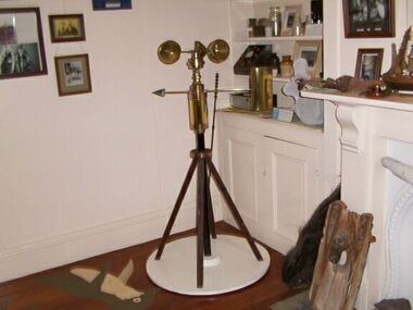
Anemometer
This device was used to measure surface wind speed and direction. This anemometer was located on a concrete pad outside room 2.15 on a steel pole. The pole was considered unsafe and the anemometer was relocated to it's current position. When lowering the pole it fell over and was badly damaged. The Bureau of Meteorology donated it to the museum. It was then repaired and restored. The central pole on which it is mounted is galvanised iron pipe painted black. The anemometer, a portable device that manually measures wind speed, was a necessary instrument once common to all weather stations. The arms are attached to a vertical rod and as the wind blows, the cups rotate, making the rod spin. The stronger the wind blows, the faster the rod spins. The anemometer counts the number of rotations, or turns, which is used to calculate wind speed, surface wind and direction. They were designed to be durable to withstand the corrosive environment and strong winds expected at coastal sites such as those at Gabo Island. Anemometers existed in the nineteenth century and their design was improved by various experts including John Robinson in 1846, John Patterson in 1926, Brevoort and Joiner in 1935 and Derek Watson in 1991 who added wind direction measurement to its functions. This example was made for the Bureau of Meteorology by the Melbourne instrument company, Synchrotac, which became registered and incorporated on 26 July 1966. It is now displayed inside the building. A good example of its kind, the anemometer has first level contributory significance for its historic value and provenance to the lightstation.Anemometer and tripod stand. Three cupped brass discs on rotating arms fixed to turned brass cylinder shaped shaft. Beneath discs is a lead directional wind arrow attached to a rotating arm. A wooden three legged stand with central supporting pole of black painted hardwood and attached to a white painted marine ply circular base.Under wind cups: " SYNCHROTAC / MELB. / ser.no.70/372 / MADE IN AUSTRALIA." Above wind direction arrow: "C.OF.APT..../ SYNCHROTAC / MELB ? MADE IN AUSTRALIA / ser.no.70/372" -
 Bendigo Historical Society Inc.
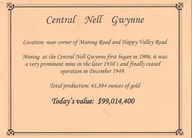
Document - CENTRAL NELL GWYNNE GOLD MINE
Interpretive sign and 4 photos Central Nell Gwynne Gold Mine, used in display. Central Nell Gwynne was located near the corner of Marong Road and Happy Valley Road. Opened in 1906, ceased operation in December 1949. Total production: 61,884 ounces of Gold. Today's Value: $99,014,400. Photos: a. Colour photo, concrete footings at mine site, April 2012. b. Colour photo, Central Nell Gwynne poppet head, April 2012.Poppet head painted white with red trim. Concrete footings in foreround. c. Central Nell Gwynne mine site 1930's. Poppet head and engine room sheds on LH side, trestle way to primary crusher and crushing battery. Tailing dam in immediate foreground. on RH side. Sand heaps in middle foreground. d. Central Nell Gwynne Mine 1930. Underground view, men holding carbide lamps working at 265 level in mine. Large quartz spur formation visible in foreground.bendigo, mining, central nell gwynne -
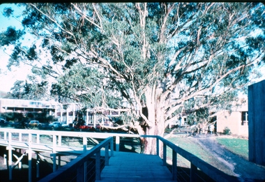 Federation University Historical Collection
Photograph - Colour photograph, Tree of Knowledge, Mount Helen Campus, 1985
The Tree of Knowledge in the central feature of the Mount Helen campus.A large tree known as the Tree of Knowledge on Mount Helen Campus.tree of knowlege, big tree, mount helen campus -
 Eltham District Historical Society Inc
Photograph, Intersection of Main Road and Henry Street, Eltham, February 1968, Feb 1968
Shows the railway trestle bridge and Eltham Central ParkIn February 1968 an unknown person took a series of photos from the Eltham Hotel at Pitt Street heading north along Main Road through the shopping centre to just north of Elsa Court covering the length of the section of Main Road which was duplicated shortly thereafter. Shows the condition and environment of the streesscape of Main Road, Eltham immediately prior to the duplication between Pitt Street and Elsa Court through the shopping centre. Also shows a number of shops and businesses that operated at that time.Black and white photographduplication, eltham, main road, henry street, trestle bridge, eltham central park -
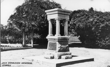 Stawell Historical Society Inc
Photograph, Mr Jack Donaldson Memorial in Central Park Stawell 1940’s
Central Park - Jack Donaldson Memorial 1940’sstawell -
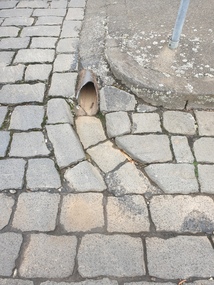 Ballarat Heritage Services
Photograph - Digital photograph, Bluestone gutter and Drain, Lydiard Street South, Ballarat, 2020, 15/02/2020
Bluestone gutters are a feature of the Ballarat Central Business District.Colour photograph of a bluestone drain on the corner of Lydiard Street South and Chancery Lane. bluestone, gutter, drain, lydiard street south -
 Tatura Irrigation & Wartime Camps Museum
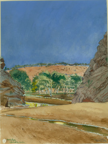
Painting - Painting - Watercolour, Emily Gap, Central Australia
Done by Leonhard Adam, Emily Gap central Australia leonhard adam, emily gap nt -
 Stawell Historical Society Inc
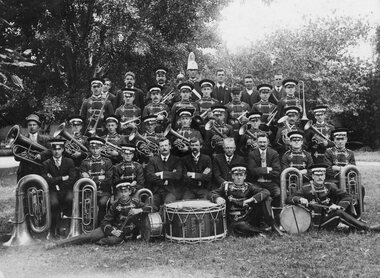
Photograph, Stawell Brass Band 1912 -- possibly at Central Park
Stawell Brass Band 1912 possibly at Central Park.stawell entertainment -
 Stawell Historical Society Inc
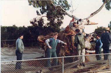
Photograph, Large Redgum Corroboree Tree fallen at Central Park with workmen assessing the damage -- Coloured
Corroboree Tree – Central Park Workmen looking at treestawell -
 Stawell Historical Society Inc
Photograph, Stawell No2 Cricket Eleven -- Central Park Match
Stawell No2 Cricket Eleven - Central Park Matchstawell sport -
 Stawell Historical Society Inc
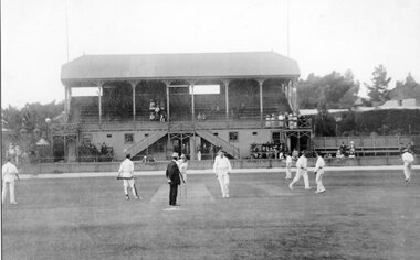
Photograph, Stawell Central Park Sports Oval with Cricketers and No 1 Grandstand
Central Park Sports Oval with Cricketers and No 1 Grandstand.stawell sport -
 Stawell Historical Society Inc
Photograph, Central Park & Sundial Stawell -- Postcard
Murray Views No. 1. Central Park and Sundial Stawellstawell -
 Stawell Historical Society Inc
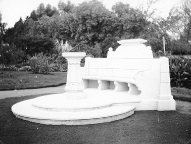
Photograph, Memorial Seat & Sundial at Central Park Stawell 1931
Memorial Seat & Sundial at Central Park. May 1931.stawell -
 Stawell Historical Society Inc
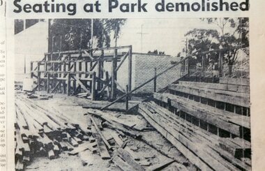
Photograph, Central Park - Old Seating being demolished 1972
Central Park - Old Seating being demolished 1972stawell -
 Bendigo Historical Society Inc.
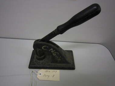
Tool - MCCOLL,RANKIN,STANISTREET COLLECTION: COMPANY SEAL
Collection: McColl, Rankin, Stanistreet. Cast iron hand press company seal for the Central Nell Gwynne Gold Mining Company, used to seal all official documents pertaining to the Central Nell Gwynne Gold Mining Company. Black enamelled body with gold floral decoration, lever with wooden handle & brass seal. Painted in white C.N.Gwy.commerce, office equipment, company seal -
 Bendigo Historical Society Inc.
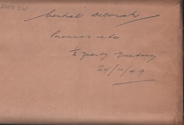
Document - MCCOLL, RANKIN AND STANISTREET COLLECTION:CENTRAL DEBORAH GOLD MINE, 24/10/49
'Printed Paper Sheets for Central Deborah Gold Mining Co. NL, Proxy forms completed and returned for half yearly meeting on 24/10/49'. Folded in a brown paper envelope with hand writing 'Central Deborah Proxies Etc 1/2 Yearly Meeting 24/10/49' by McColl,Rankin & Stanistreet Legal Managers & Accountants.McColl,Rankin & Stanistreet Legal Managers & Accountants.cottage, miners, central deborah gold mine, gold mine, mccoll rankin & stanistreet, bendigo, business records -
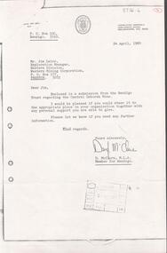 Bendigo Historical Society Inc.
Document - KANGAROO FLAT GOLD MINE COLLECTION: SUBMISSION TO WESTERN MINING CORPORATION BY CENTRAL DEBORAH GOLD MINE
Letter from Daryl McClure, M.L.A.Member for Bendigo, 24th April, 1980, to Jim Lalor, Exploration Manager, Eastern Division, Western Mining Corporation, Preston. Attached is six page submission titled 'The Bendigo Trust, Central Deborah Gold Mine, submission to Western Mining Corporation 'to request financial assistance for the further development of the Central Deborah Gold Mine'.bendigo, gold mining, central deborah gold mineg, central deborah gold mine, western mining corporation, jim lalor, daryl mcclure. -
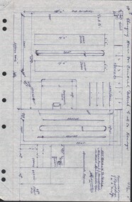 Bendigo Historical Society Inc.
Document - CENTRAL DEBORAH GOLD MINE - PLAN OF CHANGING HOUSE
Hand drawn plan for Changing House for Central Deborah G. M. Co. Bendigo. Drawn by A. Richardson 14/11/1971. Drawing has approx. measurements and is not drawn to scale. Also some Central Deborah Gold Mine Information . Ref. Mines Dept. Surface Plan 15/1/1954. Written by A Richardson 14/12/1971.mine, gold, central deborah gold mine, central deborah gold mine, plan of changing house, a richardson, mines dept. surface plan 15/1/1954 -
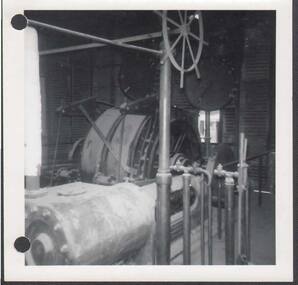 Bendigo Historical Society Inc.
Photograph - MINING PHOTOGRAPHS
Black & White photographs of 1960's mining equipment located Bendigo. [a] Deborah Engine room caption. [b] North Deborah Battery caption. [c] Central Deborah caption. [d] Central Deborah approx 1968 caption. [e] North Deborah Battery caption. [f] Deborah Engine Room caption. [g] South Deborah caption.bendigo, gold mining, gold mine -
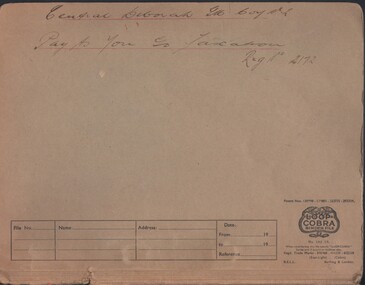 Bendigo Historical Society Inc.
Document - MCCOLL, RANKIN AND STANISTREET COLLECTION: CENTRAL DEBORAH MINE NL - TAXATION FORMS, 1944 - 1954
Document: McColl, Rankin & Stanistreet Collection: pay as you go taxation reg. No. 2172, Central Deborah Mine. Manilla folder containing instalment deductions remittances to taxation dept. for 1954. Folder has ' Central Deborah GM Coy NL, pay as you go taxation, Reg. No. 2172' written on front cover in faded black ink.organization, business, central deborah gold mine, mccoll, rankin & stanistreet collection: central deborah gold mine nl, taxation -
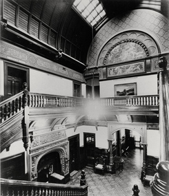 Kew Historical Society Inc
Photograph - Central Hall, 'Tara Hall', Studley Park Road, Marc Strizic, c.1960
'Lost Glories: a memorial to forgotten Australian buildings' was published by David Latta in 1986. It tells the story of a number of significant Australian buildings that had previously been demolished. A chapter in the book was devoted to Goathland, later known as Tara Hall. To supplement the text, he sourced photographs from a range of suppliers, chiefly the Royal Women's Hospital which had once owned Tara Hall, but had sold it in 1960. This is one of the photographs donated to KHS by the author.Central Hall, Tara Hall, circa 1957. The central hallway and grand staircase of Tara Hall (previously named Byram, Goathland and Lowan). This photograph provides the clearest evidence of the scale and building materials selected by Edward George Kilburn, of Ellerker & Kilburn, for the industrialist George Ramsden in 1888. These include the murals on the second floor, the use of skylights, and the vaulted wooden panelling. byram, goathland, tara hall, lowan, studley park (kew), george ramsden, sir malcolm mceacharn, edward george kilburn (architect), studley park road (kew) -
![Central Avenue, Fitzroy Gardens / [by] Nicholas Caire, circa 1876](/media/collectors/550653872162f11fb04854aa/items/57773e53d0cdd10a5c0ccd3b/item-media/57773f3fd0cdd10a5c0d358d/item-fit-380x285.jpg) Kew Historical Society Inc
Kew Historical Society IncPhotograph, Anglo-Australasian Photographic Company, Central Avenue, Fitzroy Gardens, c. 1876
Nicholas Caire was born on Guernsey in the Channel Islands in 1837. He arrived in Adelaide with his parents in about 1860. In 1867, following photographic journeys in Gippsland, he opened a studio in Adelaide. From 1870 to 1876 he lived and worked in Talbot in Central Victoria. In 1876 he purchased T. F. Chuck's studios in the Royal Arcade Melbourne. In 1885, following the introduction of dry plate photography, he began a series of landscape series, which were commercially successful. As a photographer, he travelled extensively through Victoria, photographing places few of his contemporaries had previously seen. He died in 1918. Reference: Jack Cato, 'Caire, Nicholas John (1837–1918)', Australian Dictionary of Biography.An original, rare photograph from the series 'Views of Victoria: General Series' by the photographer, Nicholas Caire (1837-1918). The series of 60 photographs that comprise the series was issued c. 1876 and reinforced a neo-Romantic view of the Australian landscape to which a growing nationalist movement would respond. Nicholas Caire was active as a photographer in Australia from 1858 until his death in 1918. His vision of the Australian bush and pioneer life had a counterpart in the works of Henry Lawson and other nationalist poets, authors and painters.Albumen Silver Photograph, mounted on Board.printed in ink on support l.c.: CENTRAL AVENUE, FITZROY GARDENS / COPYRIGHT REGISTERED. printed in ink on support reverse c.: VIEWS OF VICTORIA. / (GENERAL SERIES.) / No. 2. / CENTRAL AVENUE, FITZROY GARDENS. / The Fitzroy Gardens have, for several years past, become one of the most popular places for public resort- / attributable, no doubt, to the great variety of picturesque scenes they contain. Shrubs and flower plants, of almost / every description, can be seen growing in rich profusion within the enclosures, studded here and there with choice / pieces of statuary. The subject of the present illustration is but one of the many to be found within their precincts. / The distance of these gardens from the Melbourne Post Office is about one mile. printed in ink on support reverse l.c.l.: J.W. FORBES, Agent, printed in ink on support reverse l.c.: ANGLO-AUSTRALASIAN PHOTOGRAPHIC COMPANY, MELBOURNE. printed in ink on support reverse l.c.r.: 10 Temple Court, Collins Street West.nicholas caire (1837-1918), landscape photography -
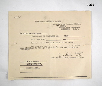 Bendigo Military Museum
Letter - LETTER, CERTIFICATE OF DISCHARGE, Australian Military Forces, C. 1957
William Malcolm (Bill) Forrest, served Korea and Malaya. Refer Cat No 7281P for his two service engagements.Letter, paper yellowed, A11/B/, Central Army Records Office. Letter relates to the issue of a Discharge Certificate to 5/1788 William Forrest.Main points.: "5/1788 Spr W.M. Forrest", "P35010" "Mr W.M. Forrest, Spring Gully Rd Bendigo Vic"letter, discharge, korea, malaya -
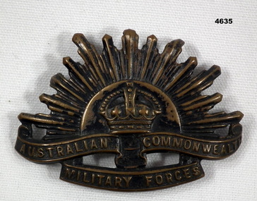 Bendigo Military Museum
Badge - RISING SUN, C.1939 - 45
Alan Mason collection, refer 3979.2Badge, brass, Slouch hat, Rising sun depiction, central crown, scroll under with “Australian Commonwealth Military Forces”, two lugs on rear.badges, rising sun -
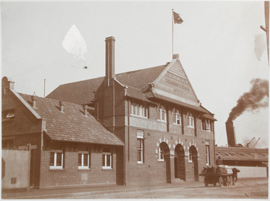 Mission to Seafarers Victoria
photograph - Photograph, Sepia, between 1910 and 1917
The photograph was taken after 1910 when the chapel, on the left, was built.This is a rare photograph of the Central Institute built in 1907 replaced by the Flinders Street Institute in 1917. The two buildings coexisted for many years until the this one was demolished (date still unknown).Small monochrome photograph at 45 degree angle depicting a horse carriage passing in front of the Siddeley Street mission, known as the Central Seamen Institute.In pencil: 137seamen institute, siddeley street, brick, huddard company, australian wharf, horse carriage, smoke, flag, chapel, walter richmond butler (1864–1949), goldsmith album -
 Glenelg Shire Council Cultural Collection
Clothing - Child's Petticoat, 1900s
Part of Graham Collection, donated by the Family of Misses Mary and Edith Maude Graham, of 4 Blair Street, Portland.White lawn infant's dress. Gathered at waist. Gathered at neck forming shoulder straps. Embroidered central panel from front waist to hem.childhood, clothing, embroidery -
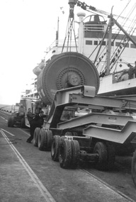 Glenelg Shire Council Cultural Collection
Photograph, Vessel 'Ixion' berthed to discharge a heavy lift for APML (Australian Paper Manufacturers), October 1959, 1959
Port of Portland ArchivesFront: (no inscriptions) Back: 6-5/8 x 4½ 120# 8036 (centre, blue pen)port of portland -
 Federation University Historical Collection
Plan, Lease Application Field Notes No. 676. James Richardson, 28 January 1893
Foolscap size hand drawn ink plan near Morgan St and along Yarrowee Creek with State School and Weslyan Church central on page.Titled 'Correct Copy of Fieldnotes Lease Application No 676 JAMES RICHARDSON' also handwritten below this is 'Robert Davidson Surveyor 28th Jany/93'