Showing 975 items
matching drill
-
 Ringwood and District Historical Society
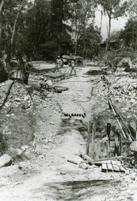
Photographs, 1979-80 MMBW pipe line project at Hubbard Reserve, North Ringwood
Part of a 43-photo record of the MMBW engineering feat in drilling a 12 inch pipe line up to 40 feet deep through rock hardened by volcanic action associated with geological fault that occurs along the line. The work took place from October 1979 to May 1980 on the southern boundary of Hubbard Reserve, North Ringwood. The collection was presented to the Ringwood Historical Research Group by J Clarke on 9th June 1980."E565 N8 16 April 1980 A43 The pipe laying has been finished, now to cover it all in." -
 Ringwood and District Historical Society
Photographs, 1979-80 MMBW pipe line project at Hubbard Reserve, North Ringwood � The grip of the mole
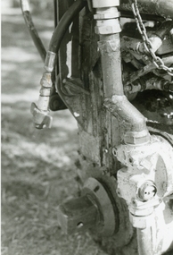
Part of a 43-photo record of the MMBW�s engineering feat in drilling a 12 inch pipe line up to 40 feet deep through rock hardened by volcanic action associated with geological fault that occurs along the line. The work took place from October 1979 to May 1980 on the southern boundary of Hubbard Reserve, North Ringwood. The collection was presented to the Ringwood Historical Research Group by J Clarke on 9th June 1980.E565 N11 28 April 1980 A43 The grip of the mechanical mole. The square at the bottom revolves, turning the sectioned shaft that carries the mole at its end. -
 Ringwood and District Historical Society
Photographs, 1979-80 MMBW pipe line project at Hubbard Reserve, North Ringwood � hydraulic mole
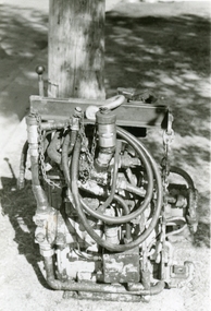
Part of a 43-photo record of the MMBW�s engineering feat in drilling a 12 inch pipe line up to 40 feet deep through rock hardened by volcanic action associated with geological fault that occurs along the line. The work took place from October 1979 to May 1980 on the southern boundary of Hubbard Reserve, North Ringwood. The collection was presented to the Ringwood Historical Research Group by J Clarke on 9th June 1980.E565 N10 28 April 1980 A43 The "muscles" of the mechanical mole, driven by a hydraulic line from a powerful "power pack". -
 Ringwood and District Historical Society
Photographs, 1979-80 MMBW pipe line project at Hubbard Reserve, North Ringwood � Line of tunnel shafts
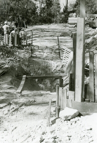
Part of a 43-photo record of the MMBW�s engineering feat in drilling a 12 inch pipe line up to 40 feet deep through rock hardened by volcanic action associated with geological fault that occurs along the line. The work took place from October 1979 to May 1980 on the southern boundary of Hubbard Reserve, North Ringwood. The collection was presented to the Ringwood Historical Research Group by J Clarke on 9th June 1980.E561 N8 Feb 1980 A43 Line of tunnel shafts running from bottom centre to left of centre -
 Ringwood and District Historical Society
Photographs, 1979-80 MMBW pipe line project at Hubbard Reserve, North Ringwood � Tunnel shafts
Part of a 43-photo record of the MMBW�s engineering feat in drilling a 12 inch pipe line up to 40 feet deep through rock hardened by volcanic action associated with geological fault that occurs along the line. The work took place from October 1979 to May 1980 on the southern boundary of Hubbard Reserve, North Ringwood. The collection was presented to the Ringwood Historical Research Group by J Clarke on 9th June 1980.E561 N12 Feb 1980 A43 Line of tunnel shafts at 29-30 Burlock Avenue showing swivel cranes 5 and 6 from the bore-hole in Lot 7 -
 Ringwood and District Historical Society
Photographs, 1979-80 MMBW pipe line project at Hubbard Reserve, North Ringwood � MMBW compound in Evelyn Road
Part of a 43-photo record of the MMBW�s engineering feat in drilling a 12 inch pipe line up to 40 feet deep through rock hardened by volcanic action associated with geological fault that occurs along the line. The work took place from October 1979 to May 1980 on the southern boundary of Hubbard Reserve, North Ringwood. The collection was presented to the Ringwood Historical Research Group by J Clarke on 9th June 1980.E563 N2 12 April 1980 A43 MMBW compound in Evelyn Road gully -
 Ringwood and District Historical Society
Photographs, 1979-80 MMBW pipe line project at Hubbard Reserve, North Ringwood � Sewer tunnel
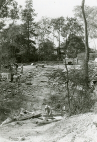
Part of a 43-photo record of the MMBW�s engineering feat in drilling a 12 inch pipe line up to 40 feet deep through rock hardened by volcanic action associated with geological fault that occurs along the line. The work took place from October 1979 to May 1980 on the southern boundary of Hubbard Reserve, North Ringwood. The collection was presented to the Ringwood Historical Research Group by J Clarke on 9th June 1980.E561 N7 Feb 1980 A43 Work on sewer tunnel below Burlock Avenue. Line of shafts running from manhole in gully to the consecutive groups on top left. -
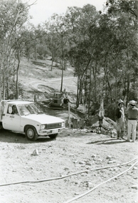
 Ringwood and District Historical Society
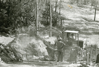
Photographs, 1979-80 MMBW pipe line project at Hubbard Reserve, North Ringwood � Nissan backhoe digging for the broken mole
Part of a 43-photo record of the MMBW�s engineering feat in drilling a 12 inch pipe line up to 40 feet deep through rock hardened by volcanic action associated with geological fault that occurs along the line. The work took place from October 1979 to May 1980 on the southern boundary of Hubbard Reserve, North Ringwood. The collection was presented to the Ringwood Historical Research Group by J Clarke on 9th June 1980.E563 N4 12 April 1980 A43 Nissan backhoe digging for the broken mole -
 Ringwood and District Historical Society
Photographs, 1979-80 MMBW pipe line project at Hubbard Reserve, North Ringwood � Finished manhole
Part of a 43-photo record of the MMBW�s engineering feat in drilling a 12 inch pipe line up to 40 feet deep through rock hardened by volcanic action associated with geological fault that occurs along the line. The work took place from October 1979 to May 1980 on the southern boundary of Hubbard Reserve, North Ringwood. The collection was presented to the Ringwood Historical Research Group by J Clarke on 9th June 1980.E566 N15 13 May 1980 A43 The finished manhole in the gully. The tall stake is the line of the boundary of Hubbard Park. -
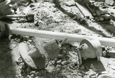 Ringwood and District Historical Society
Photographs, 1979-80 MMBW pipe line project at Hubbard Reserve, North Ringwood � Broken mole
Part of a 43-photo record of the MMBW�s engineering feat in drilling a 12 inch pipe line up to 40 feet deep through rock hardened by volcanic action associated with geological fault that occurs along the line. The work took place from October 1979 to May 1980 on the southern boundary of Hubbard Reserve, North Ringwood. The collection was presented to the Ringwood Historical Research Group by J Clarke on 9th June 1980.E565 N9 16 April 1980 A43 The broken mole back-reamer whose jamming held up the job for four weeks -
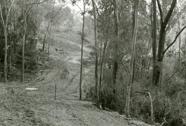
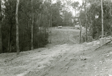
 Ringwood and District Historical Society
Photographs, 1979-80 MMBW pipe line project at Hubbard Reserve, North Ringwood � Viewing east from Debbie Place
Part of a 43-photo record of the MMBW�s engineering feat in drilling a 12 inch pipe line up to 40 feet deep through rock hardened by volcanic action associated with geological fault that occurs along the line. The work took place from October 1979 to May 1980 on the southern boundary of Hubbard Reserve, North Ringwood. The collection was presented to the Ringwood Historical Research Group by J Clarke on 9th June 1980.E568 N18 13 May 1980 A43 Viewing east from ridge above Debbie Place -
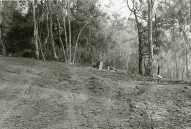
 Ringwood and District Historical Society
Photographs, 1979-80 MMBW pipe line project at Hubbard Reserve, North Ringwood � View east up the gully
Part of a 43-photo record of the MMBW�s engineering feat in drilling a 12 inch pipe line up to 40 feet deep through rock hardened by volcanic action associated with geological fault that occurs along the line. The work took place from October 1979 to May 1980 on the southern boundary of Hubbard Reserve, North Ringwood. The collection was presented to the Ringwood Historical Research Group by J Clarke on 9th June 1980.E568 N19 13 May 1980 A43 View east up the gully, when all the work was finished -
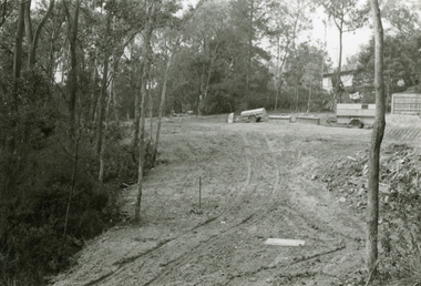
 Ringwood and District Historical Society
Photographs, 1979-80 MMBW pipe line project at Hubbard Reserve, North Ringwood � Looking east near Debbie Place
Part of a 43-photo record of the MMBW�s engineering feat in drilling a 12 inch pipe line up to 40 feet deep through rock hardened by volcanic action associated with geological fault that occurs along the line. The work took place from October 1979 to May 1980 on the southern boundary of Hubbard Reserve, North Ringwood. The collection was presented to the Ringwood Historical Research Group by J Clarke on 9th June 1980.E567 N16 13 May 1980 A43 Looking east from the ridge above Debbie Place. The finished manhole is in the gully. -
 Ringwood and District Historical Society
Photographs, 1979-80 MMBW pipe line project at Hubbard Reserve, North Ringwood � View east from Debbie Place
Part of a 43-photo record of the MMBW�s engineering feat in drilling a 12 inch pipe line up to 40 feet deep through rock hardened by volcanic action associated with geological fault that occurs along the line. The work took place from October 1979 to May 1980 on the southern boundary of Hubbard Reserve, North Ringwood. The collection was presented to the Ringwood Historical Research Group by J Clarke on 9th June 1980.E558 N29 13 May 1980 A43 View east from Debbie Place -
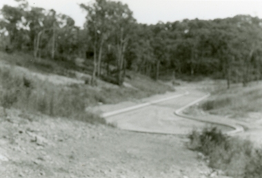
 Ringwood and District Historical Society
Photographs, 1979-80 MMBW pipe line project at Hubbard Reserve, North Ringwood � Track down to creek bridge
Part of a 43-photo record of the MMBW�s engineering feat in drilling a 12 inch pipe line up to 40 feet deep through rock hardened by volcanic action associated with geological fault that occurs along the line. The work took place from October 1979 to May 1980 on the southern boundary of Hubbard Reserve, North Ringwood. The collection was presented to the Ringwood Historical Research Group by J Clarke on 9th June 1980.E565 N12 13 May 1980 A43 My old track down to the bridge over the creek. The pipe line went to the right of the big tree 40-foot down. -
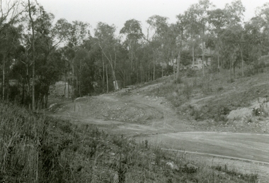
 Ringwood and District Historical Society
Photographs, 1979-80 MMBW pipe line project at Hubbard Reserve, North Ringwood � The new trach goes on down to Debbie Place
Part of a 43-photo record of the MMBW�s engineering feat in drilling a 12 inch pipe line up to 40 feet deep through rock hardened by volcanic action associated with geological fault that occurs along the line. The work took place from October 1979 to May 1980 on the southern boundary of Hubbard Reserve, North Ringwood. The collection was presented to the Ringwood Historical Research Group by J Clarke on 9th June 1980.E566 N13 13 May 1980 A43 The parting of the ways. My old track goes left to Burlock Avenue. The new way goes on down to Debbie Place. -
 Ringwood and District Historical Society
Photographs, 1979-80 MMBW pipe line project at Hubbard Reserve, North Ringwood � Manhole behind 29 Burlock Avenue
Part of a 43-photo record of the MMBW�s engineering feat in drilling a 12 inch pipe line up to 40 feet deep through rock hardened by volcanic action associated with geological fault that occurs along the line. The work took place from October 1979 to May 1980 on the southern boundary of Hubbard Reserve, North Ringwood. The collection was presented to the Ringwood Historical Research Group by J Clarke on 9th June 1980.E566 N5 13 May 1980 A43 Manhole behind 29 Burlock Avenue, 38 feet deep. Debbie place is on the far right. -
 Ringwood and District Historical Society
Photographs, 1979-80 MMBW pipe line project at Hubbard Reserve, North Ringwood � The manhole in the creek
Part of a 43-photo record of the MMBW�s engineering feat in drilling a 12 inch pipe line up to 40 feet deep through rock hardened by volcanic action associated with geological fault that occurs along the line. The work took place from October 1979 to May 1980 on the southern boundary of Hubbard Reserve, North Ringwood. The collection was presented to the Ringwood Historical Research Group by J Clarke on 9th June 1980.E563 1 April 1980 A43 The manhole in the creek, waiting until boring is finished. -
 Ringwood and District Historical Society
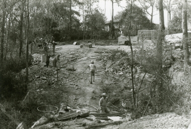
Photographs, 1979-80 MMBW pipe line project at Hubbard Reserve, North Ringwood � Last days of the boring
Part of a 43-photo record of the MMBW�s engineering feat in drilling a 12 inch pipe line up to 40 feet deep through rock hardened by volcanic action associated with geological fault that occurs along the line. The work took place from October 1979 to May 1980 on the southern boundary of Hubbard Reserve, North Ringwood. The collection was presented to the Ringwood Historical Research Group by J Clarke on 9th June 1980.E561 N1 1 April 1980 A43 Last days of the boring. The mole had broken between the last two shafts. Dominic Di Nezza and Glen Pearson discuss further moves to release it. -
 Ringwood and District Historical Society
Photographs, 1979-80 MMBW pipe line project at Hubbard Reserve, North Ringwood � Boring mole pit
Part of a 43-photo record of the MMBW�s engineering feat in drilling a 12 inch pipe line up to 40 feet deep through rock hardened by volcanic action associated with geological fault that occurs along the line. The work took place from October 1979 to May 1980 on the southern boundary of Hubbard Reserve, North Ringwood. The collection was presented to the Ringwood Historical Research Group by J Clarke on 9th June 1980.E561 N14 3 March 1980 A43 View west behind No. 29 Burlock Avenue, showing gantry over manhole 38 feet deep. -
 Ringwood and District Historical Society
Photographs, 1979-80 MMBW pipe line project at Hubbard Reserve, North Ringwood � The work on sewer line from 29-39 Burlock Avenue
Part of a 43-photo record of the MMBW�s engineering feat in drilling a 12 inch pipe line up to 40 feet deep through rock hardened by volcanic action associated with geological fault that occurs along the line. The work took place from October 1979 to May 1980 on the southern boundary of Hubbard Reserve, North Ringwood. The collection was presented to the Ringwood Historical Research Group by J Clarke on 9th June 1980.E561 N11 3 March 1980 A43 The work on sewer line from 29-39 Burlock Avenue. Lundy-Clarke's place on sky-line. -
 Ringwood and District Historical Society
Photographs, 1979-80 MMBW pipe line project at Hubbard Reserve, North Ringwood � View from Debbie Place, preliminary sewer work
Part of a 43-photo record of the MMBW�s engineering feat in drilling a 12 inch pipe line up to 40 feet deep through rock hardened by volcanic action associated with geological fault that occurs along the line. The work took place from October 1979 to May 1980 on the southern boundary of Hubbard Reserve, North Ringwood. The collection was presented to the Ringwood Historical Research Group by J Clarke on 9th June 1980.E561 N13 28 Feb 1980 A43 View from Debbie Place, preliminary sewer work -
 Ringwood and District Historical Society
Photographs, 1979-80 MMBW pipe line project at Hubbard Reserve, North Ringwood � Line of tunnel shafts behind 29-39 Burlock Avenue
Part of a 43-photo record of the MMBW�s engineering feat in drilling a 12 inch pipe line up to 40 feet deep through rock hardened by volcanic action associated with geological fault that occurs along the line. The work took place from October 1979 to May 1980 on the southern boundary of Hubbard Reserve, North Ringwood. The collection was presented to the Ringwood Historical Research Group by J Clarke on 9th June 1980.E561 N10 Feb 1980 A43 Line of tunnel shafts behind 29-39 Burlock Avenue. Horizontal gantry was above the manhole in the corner of No. 29. -
 Ringwood and District Historical Society
Photographs, 1979-80 MMBW pipe line project at Hubbard Reserve, North Ringwood � First hole west of bore hole at 39 Burlock Avenue
Part of a 43-photo record of the MMBW�s engineering feat in drilling a 12 inch pipe line up to 40 feet deep through rock hardened by volcanic action associated with geological fault that occurs along the line. The work took place from October 1979 to May 1980 on the southern boundary of Hubbard Reserve, North Ringwood. The collection was presented to the Ringwood Historical Research Group by J Clarke on 9th June 1980.E561 N9 Feb 1980 A43 First hole west of bore hole at 39 Burlock Avenue -
 Flagstaff Hill Maritime Museum and Village
Wood Sample, 1854
This timber fragment is from the shipwreck of the SCHOMBERG (1855). The bow of the ship broke off after an unsuccessful salvage attempt to tow her off the Peterborough reef. At the wreck-site the submerged hull points north towards the beach but the front section is missing. Parts of the bow have been carried away by the eastward bearing ocean currents and have come ashore on the western coast of New Zealand’s South Island. Don Charlwood writes in Wrecks & Reputations (1977) that in 1871 “a piece of wreckage over 20 feet long and 12 feet wide was brought out” by land from its remote location at Tauperika Creek. In 1875 “an even larger section was brought out by sea”. It was suggested at the time that these relics of a large wooden sailing ship were from the wreck of the SCHOMBERG some 20 years earlier on the Victorian coast. “To corroborate the theory”, Charlwood continues, “a piece was sent to Halls of Aberdeen [the ship’s builders in Scotland]. They identified it as having come from the ship they had launched with such pride in 1852.” Charlwood, whose great-grandparents were passengers on the SCHOMBERG’s fateful maiden voyage, acquired some samples of the wreckage timber recovered in New Zealand, and brought them back with him to Australia. In 1976 “comparison was made of timbers from the New Zealand find and timber from the remains of the hull at Peterborough. They proved to be from the same ship.” The extraordinary journey of these pieces of wood from the once mighty clipper ship SCHOMBERG came to an end in 1984, when they were given to Flagstaff Hill by the author, and reunited with other shipwreck timbers and copper bolts from the vessel that are on display at the Maritime Village. The shipwreck of the SCHOMBERG is of State significance - Victorian Heritage Register S612A piece of wood broken from the timbers of the shipwrecked SCHOMBERG (1855, Peterborough) and retrieved from the southwest coast of New Zealand’s South Island. The artefact is a light grey colour with plain long grain and bears a reddish stain on parts. Part of a drilled hole is red stained with traces of corroded metal still evident. The piece appears to have split off from other fragments that are in the Flagstaff Hill collection (6257, 6258) and it is in fragile condition.flagstaff hill, warrnambool, shipwrecked-coast, flagstaff-hill, flagstaff-hill-maritime-museum, maritime-museum, shipwreck-coast, flagstaff-hill-maritime-village, schomberg, shipwreck timber, don charlwood, ‘wrecks & reputations’ -
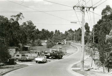
 Ringwood and District Historical Society
Photograph, 1979-80 MMBW pipe line project at Hubbard Reserve, North Ringwood. Debbie Place from the east end
Part of a 43-photo record of the MMBW's engineering feat in drilling a 12 inch pipe line up to 40 feet deep through rock hardened by volcanic action associated with geological fault that occurs along the line. The work took place from October 1979 to May 1980 on the southern boundary of Hubbard Reserve, North Ringwood. The collection was presented to the Ringwood Historical Research Group by J Clarke on 9th June 1980.E550 N12 Dec 1979 A43 Debbie Place from the east end -
 Bendigo Historical Society Inc.
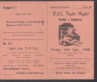
Document - R.S.L. BENDIGO COLLECTION: R.S.L. FIGHT NIGHT BENDIGO V. SHEPPARTON, 24th September, 1948
Light orange/tan Souvenir Programme titled R.S.L. Fight Night Bendigo v. Shepparton Friday, 24th Sept., 1948 at the Mollison Street Drill Hall, Bendigo. On the front is a drawing of boxers, the date and place. On the inside are the names of the Officials, the Contestants and local businesses: T.D.Cairns & Son, Hartleys (Bendigo), R. J. Conroy and Palma Dance. On the back are advertisements to join the Bendigo Branch of R.S.S.A.I.L.A. and the Bendigo Y.M.C.A. Printed by Cambridge Press Bendigo.Cambridge Press, Bendigoevent, sports, r.s.l., r.s.l. bendigo collection - r.s.l. fight night bendigo v. shepparton, mollison street drill hall bendigo, rules victorian amateur boxing and wrestling association, bendigo y.m.c.a. amateur boxing club, bendigo sub-branch r.s.s.a.i.l.a., t d cairns & son, leo forrest, carl ermel, lyn murdoch, lee mann, col wills, rex porter, ron davies, harvey cox, col. g v lansell m>l>c>, b carruthers, r batterham, y.m.c.a.-bendigo-spring gully-north bendigo-shepparton, h cahill, bendigo red cross emergency service, hartleys (bendigo), r j conroy, b davis, z hughes, r burns, l patullo, r santon, d hughes, l bennett, r forrest, s burns, n burns, j mason, p cork, g sutherland, t ritchie, g keely, a smith, k mcqueenie, j jones, k mannix, g ritchie, t clough, t o'connor, t marchingo, r allan, f allen, p grainger, palma dance, r.s.l. building fund, cambridge press bendigo -
 Bendigo Historical Society Inc.
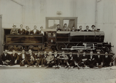
Photograph - GROUP OF MEN WITH MODEL TRAIN OUTSIDE GOLDEN SQUARE DRILL HALL
Black and white photograph of group of twenty seven men behind and in front of model train, outside large corrugated iron building. Small dog held by man 4th from L, front row. Mounted on cream board." Inscriptions:: Printed across BR corner 'WH Robinson, Photo, Bendigo' In image on engine - '18.5%'?, '1'. History : James Lerk 'A model locomotive photographed outside the Golden Square Drill Hall'.WH Robinson, Bendigobuildings, government, golden square drill hall -
 Bendigo Historical Society Inc.
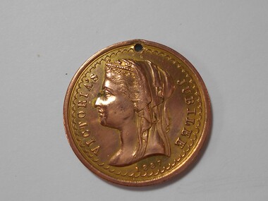
Medal - MEDAL COLLECTION: QUEEN VICTORIA JUBILEE MEDAL, 1887
Object. Brass coloured metal medal with 1mm hole drilled in top edge. This medal was produced by the Borough of Eaglehawk to commemorate the Jubilee Year of Queen Victoria. George Willan was Mayor at the time. Obverse: Crowned and veiled profile head of Queen Victoria. Around edge ''VICTORIA'S JUBILEE 1887''. Reverse: Royal Coat of Arms above an eagle with outstretched wings with mullock heap to the left and factory to the right. Around the edge ''GEORGE WILLAN MAYOR''.numismatics, medals - commemorative, queen victoria jubilee medal 1887 -
 Kiewa Valley Historical Society
Photograph - Folder of Photographs – Photocopied set of black and white photographs (pages 9 - 18) from the display folder put together by KVHS to document life on the Kiewa Valley Hydro-electric Scheme
Although the Kiewa Hydro-Electric Scheme was first proposed in 1911, construction did not commence until 1938. As part of the push to cut electricity costs and diversify supply, the Victorian Government (circa 1930) initiated the conversion from primarily brown coal supply to hydro – electricity. Field investigations during the 1940’s resulted in a new proposal for a scheme that had more than double the capacity of the 1938 scheme. The Kiewa Hydroelectric Scheme became the largest scheme of its kind in the State Of Victoria and the second largest scheme in Australia. The number of personnel involved in the planning and construction of the scheme increased dramatically. During the late 1940’s, most activity centred around the construction of the West Kiewa Power Station, Rocky Valley Reservoir, McKay Creek Power Station and the Bogong Creek Aqueduct.A common thread across all the larger hydro scheme constructions was the need for workers, both qualified and unqualified who came from around the world seeking a new life for themselves and their families. New accommodation and facilities were required for the army of workers engaged in construction in often remote and wild areas. The SEC had a high demand for timber, and set up the first of a number of sawmills at Bogong Creek in 1939 and set up the first hardwood logging in the headwaters of the Kiewa River. These new ‘towns’ such as Mt Beauty and Bogong, survived, serving the needs of operational personnel and their families, and expanding with growth of new industries. Mount Beauty, and to a lesser extent Bogong, are among these places. PHYSICAL: Large A3 size spiral bound display folder containing 21 pages of photocopied black and white photographs of various aspects of the early days of the Kiewa Valley Hydro-electric scheme including equipment, various work sites and photographs of workers and their families. 1-Bridge across Tailrace Channel 1946 2-New Mess building, Mt Beauty 3-Homan’s Gap Saw Mill 4- Diamond Drilling Plant – Big Hill 5-Rocky Valley Camp-Mess Building 6-Parlimentary Party at Rocky Valley 7-No.4 Headrace Tunnel 8- Allis-Chalmers Tractor School 9- SECV Heavy Machinery lined up by road 10- No. 5 Raceline – Balasting Track with improvised truck 1-1946 – Bridge across tailrace channel Page number 9 2-New mess building, Mt Beauty 6.4.46 Page number 10 3- STATE ELECTRICITY COMMISSION OF VICTORIA Date: 10.1.47 Time: 11.40am No K2271 Kiewa Hydro Electric Works Homan’s Gap Saw Mill – Rip Saw Page number 11 4- STATE ELECTRICITY COMMISSION OF VICTORIA Date: 5.10.47 Time: 11am No K4111 Kiewa Hydro Electric Works Diamond Drilling Plant – Big Hill Page number 12 5- STATE ELECTRICITY COMMISSION OF VICTORIA Date: 11.2.48 Time: 3pm No K4277 Kiewa Hydro Electric Works Rocky Valley Camp-Mess Building Page number 13 6- STATE ELECTRICITY COMMISSION OF VICTORIA Date: 15.4.48 Time: 4.30pm No K4397 Kiewa Hydro Electric Works Parlimentary Party at Rocky Valley Page number 14 7- STATE ELECTRICITY COMMISSION OF VICTORIA Date: 22.8.48 Time: 9am No K4668 Kiewa Hydro Electric Works General view of No.4 Headrace Tunnel Page number 15 8-STATE ELECTRICITY COMMISSION OF VICTORIA Date: 5.9.49 Time: 10am No K5180 Kiewa Hydro Electric Works Allis-Chalmers Tractor School – HD 19, Mr I Crossthwaite at Controls Page number 16 9- No markings Page number 17 10- STATE ELECTRICITY COMMISSION OF VICTORIA Date: 7,12.49 Time: 4pm No K5423 Kiewa Hydro Electric Works No. 5 Raceline – Balasting Track with improvised truck. Page number 18 secv; kiewa hydro electric scheme; mt beauty; bogong; construction area