Showing 11595 items matching " map"
-
 Whitehorse Historical Society Inc.
Map, Parks and recreation facilities, 1/06/1995 12:00:00 AM
Map of the City of Whitehorse with parks and reserves marked and indexedMap of the City of Whitehorse with parks and reserves marked and indexed.Map of the City of Whitehorse with parks and reserves marked and indexedcity of whitehorse, parks and reserves, bicycle paths, recreation facilities, blackburn, blackburn north, blackburn south, burwood east, forest hill, mitcham, nunawading, vermont, vermont south -
Whitehorse Historical Society Inc.
Map, Nunawading, c1850
Early map of Nunawading, Bulleen and part of Boroondara areas.Early map of Nunawading, Bulleen and part of Boroondara areas.Early map of Nunawading, Bulleen and part of Boroondara areas.shire of nunawading, bulleen, boroondara -
Whitehorse Historical Society Inc.
Map, City of Nunawading Community Facilities, 1983
Map of the City of Nunawading with community facilities as at April 1983.Map of the City of Nunawading with community facilities as at April 1983.Map of the City of Nunawading with community facilities as at April 1983.city of nunawading, parks and reserves -
Whitehorse Historical Society Inc.
Map, History of Nunawading, 1892
Map of the Shire of Nunawading from the Municipal Directory of 1892.shire of nunawading -
 Bendigo Military Museum
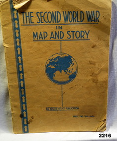
Book - BOOK WW2, The Second World War in Map and Story, During the WW2
Covers are yellow/orange with all writing in blue. Title at top, globe depiction of the world central at bottom "An Argus Production, Price Two shillings. 63 pages of history with full page map every 2nd page.books, maps, story -
 National Vietnam Veterans Museum (NVVM)
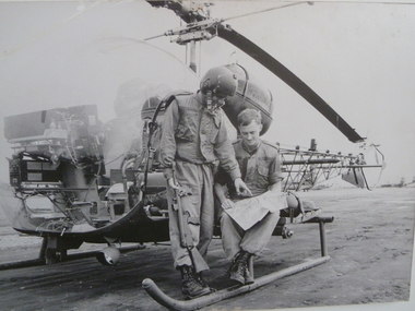
Photograph, Two 2nd Lieutenants And A Map, 1/08/1966 12:00:00 AM
Unframed photo of 2nd Lt Bob Rich and 2nd Lt Victor Salmon pilots from 161 Recon Flight check details on a map before their next mission. They are positioned next to a Bell Sioux 63B1 helicopterAWM FOR/66/0730/VNvictor salmon, bob rich, 161 reconnaissance flight, bell sioux 63b1, helicopter -
 Bendigo Military Museum
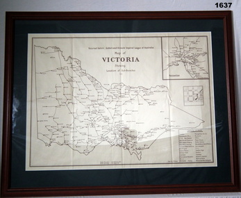
Map - RSL'S VICTORIA, FRAMED, Bethany Gallery, 1949
This map originally came via Mitiamo East Loddon RSL who when they closed their Sub branch the map and their records were handed to the Bendigo RSL for safe keeping. It was framed and was hanging in the Office of the SMI until the renovations to the building in 2016.Dark green mount with brown wooden frame. Brown printing on cream paper. Perspex covering map.Top centre of map: “Returned Sailors, Soldiers & Airmen's Imperial League of Australia Map of Victoria showing Sub Branches 1949” Stamped on rear: Bethany Gallery. Traditionally a touch of Excellence Terry ? Jarvis, 116 Bridge Street, Bendigo Vic 3550 Ph (03) 5442 4771brsl, smirsl, map rsl's -
 Whitehorse Historical Society Inc.
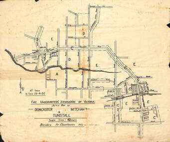
Map - Fire Underwriter's Association Sketch Map, Fire Underwriter's Association of Victoria, Doncaster, Mitcham and Tunstall, 29/4/1932
Shetch map of Doncaster, Mitcham and Tunstall. Scale 1inch = 40 chainsA sketch map of Doncaster, Mitcham and Tunstall by the Fire Underwriters' Association of Victoria.non-fictionShetch map of Doncaster, Mitcham and Tunstall. Scale 1inch = 40 chainsmap, doncaster, mitcham, tunstall -
 National Vietnam Veterans Museum (NVVM)
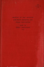
Booklet, British Army, Manual of Map Reading, Air Photo Reading And Field Sketching. Part 3, Field Sketching, 1957, 1957
A red coloured cover with black writing on the front. In the middle reads Manual of Map Reading, Air Photo Reading And Field Sketching. Part 3, Field Sketching, 1957. Top Right corner reads WO Code No. 9085.british armed forces - service manuals, ministry of defence (army) -
 Bendigo Military Museum
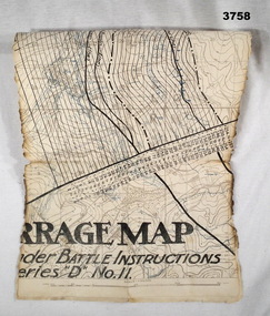
Map - BARRAGE MAP, FRANCE WW1, Possibly 1918
Villeret is centred within the areas of Rosiel, Bony, Bellicourt and Bellenglise. The map is possibly when the advance was into the Hindenburg Line in late 1918. Item re William Alexander No 502 AIF. Refer Cat No 3746.3 for his service details.Map, small section of a “Barrage map” showing objective lines with distances, enemy trenches are in blue. Top half and bottom half of the map are missing. Area covered appears to be “Villeret” scale 1:20,000map, trench, barrage -
 Federation University Historical Collection
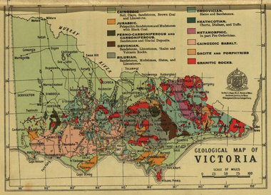
Photograph - colour, William Baragwanath, Department of Mines: Geological map of Victoria, c1935
Photograph included in book "Victoria: Gold and Minerals" issued by Mines Department Victoria, 1935Photographmap, department of mines, victoria, key to land formations, time periods, jurassic, geological map -
 Bendigo Military Museum
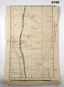
Map - MAP, RAVENSWOOD, VIC TRAINING AREA, Aust Army, Unknown
Items in the collection re Lt Col J. Swatton, refer Cat No 6719.2P for his service details.This is an enlarged version of a contour map. It is undated. On centre left is Ravenswood Train station. The Calder Highway is shown, from the bottom of the map to halfway up left side. Top right side shows "Spring Hill".Each grid square is 1000 x 1000 yards. Top right corner grid is 230,000 E, 450,000 Nth. Magnetic variation when this map was made is 6.55' grid to magnetic Nth. printed onto the map, with an "X" are 'Starting Point', "Debussing Point", and "Assembly Point" . Handwritten in red pencil at top LHS are the letters "C.O".passchendaele barracks trust, map, j.w. swatton -
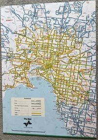 Melbourne Tram Museum
Map, The Met, "Tram and bus Routes showing destination numbers", June 1992
Titled "Tram Routes showing destination numbers". Map dated June 1992 and has been printed with The Met logo. Shows routes with route numbers, names of main destinations, roads, railway stations and rail lines, rivers, scales and Zones. Does not have the CBD insert. Same size as that of item 1099, a 1972 version. Type of map that was placed on the rear of the driver's doors of a W Class tramcar.Demonstrates a The Met produced map used in trramcars.Full colour map or poster printed on paper trimmed from original map and mounted on cardboard.Has some pen marks in the bottom left hand corner.trams, tramways, map, routes, the met -
Ringwood and District Historical Society
Cuttings, Waverley Offset Publishing, Newspaper supplement including information on Ringwood and aerial map of Ringwood Central - c.1960, c.1960
Used to promote Ringwood shopping centre and amenities, with the newspaper promoting a big future.1. Newspaper Supplement - bifold about Ringwood Aerial Map of Ringwood Central - inset photo of Mayor; 2. Two pamphlets bifold. +Additional Keywords: Smart, Gerald (Mayor) / Clarke, B.G. (Mayor) / Gazzard, Clarke (Town Planner)'Ringwood a Big Future' -
The 5th/6th Battalion Royal Victoria Regiment Historical Collection
Book, Manual of Map Reading, Photo Reading and field Sketching 1929, 1929
Pam with brown card cover. Has a Royal coat of Arms located above the title. Has several fold out maps, many of which protude from the book. On a number of the 160 pags there are diagrams which are printed in limited colour.J.G.Bowe is hand written at the top right hand corner in black ink.regimental property, wark vc club, inter war, manual -
 Federation University Historical Collection
Map, Ballarat and Sebastapol Gold Mines, Late 19th Century
colored printed map on paper lined onto linen backingprinted "Rider & Mercer's Plan of the Ballarat & Sebastapol Gold Mines Scale 30 Chains to One Inch"gold mines, mine allotment map, mining leases, ballarat, sebastopol, rider and mercer, golden shaft co, prince of wales and bonshaw united, leviathan gold mines, holst and co, speedwell co, sebastopol plateau, rothschild co, tower hill co, south plateau, south star co, band of hop and albion consols, prince regent co, chenhall and co, despza, buninyong estate, one eye hully, winter's freehold, luplau plateau, e. morey, carrill's quartz -
Whitehorse Historical Society Inc.
Map, Chisholm, 1989
Map of the Commonwealth Electoral Division of Chisholm. Scale 1:25,000.Map of the Commonwealth Electoral Division of Chisholm. Scale 1:25,000.Map of the Commonwealth Electoral Division of Chisholm. Scale 1:25,000.electoral boundaries, chisholm (commonwealth electoral division) -
Whitehorse Historical Society Inc.
Map, Deakin, 1989
Map of the Commonwealth Electoral Division of Deakin. Scale 1:25000.Map of the Commonwealth Electoral Division of Deakin. Scale 1:25000.Map of the Commonwealth Electoral Division of Deakin. Scale 1:25000.electoral boundaries, deakin (commonwealth electoral division) -
Whitehorse Historical Society Inc.
Map, Deakin, 1977
Map of the Commonwealth Electoral Division of Deakin. Scale 1: 25,000.Map of the Commonwealth Electoral Division of Deakin. Scale 1: 25,000.Map of the Commonwealth Electoral Division of Deakin. Scale 1: 25,000.electoral boundaries, deakin (commonwealth electoral division), australia. parliament -
Whitehorse Historical Society Inc.
Map, Aston, 1989
Map of the Commonwealth Electoral Division of Aston. Scale 1:25,000Map of the Commonwealth Electoral Division of Aston. Scale 1:25,000Map of the Commonwealth Electoral Division of Aston. Scale 1:25,000electoral boundaries, aston (commonwealth electoral division) -
Whitehorse Historical Society Inc.
Map, Bike Paths, 1995
Map in Boroondara Bulletin showing Bike paths in the City of Boroondara.Map in Boroondara Bulletin showing Bike paths in the City of Boroondara.Map in Boroondara Bulletin showing Bike paths in the City of Boroondara.bicycle paths, city of boroondara -
Whitehorse Historical Society Inc.
Map, City of Nunawading, c. 1960
Map showing boundaries of the City of Nunawading Scale: 1:36,000Map showing boundaries of the City of Nunawading Scale: 1:36,000Map showing boundaries of the City of Nunawading Scale: 1:36,000mitcham, nunawading, blackburn, blackburn north, blackburn south, burwood east, vermont south, forest hill, vermont -
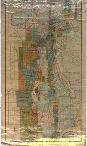
 Greensborough Historical Society
Map, Melbourne and Metropolitan Board of Works. Survey Division, MMBW, Yarra 2500 / 12.22. Watsonia North, 1978_03
Melbourne and Metropolitan Board of Works. Yarra 2500 [base map]. 12-22, Parishes of Keelbundora 2856, Municipalities of Whittlesea 239 and Diamond Valley 257. Shows street names, easement sizes, lot numbers, lodged plan numbers, names of prominent features, contour values, creek or river names. Watsonia Railway Station and environs. Prominent streets: Edmund Rice Parade and Macorna Street. Includes Christian Brothers Edmund Rice College and Janefield Special School sites and "proposed future freeway" (now Metropolitan Ring Road).MMBW Map in 1:2500 [scale] series. Cream parchment with green tape reinforcing on edges and punched holes on left edge.mmbw, melbourne and metropolitan board of works, shire of diamond valley, watsonia - maps, bundoora - maps -
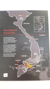 National Vietnam Veterans Museum (NVVM)
Map, New Zealand's Vietnam's War
On a black background is the story of New Zealand's Vietnam War from June 1964 to December 1972. It details the number of soldiers who served and the number of soldiers who lost their life and were wounded. Surrounding the wall map there is a description of the 10 areas where New Zealand Solders were based. They are listed below in the keywords section.map, new zealand, bong son, qui nhon, dong ba thin, bien hoa, nui dat, vung tau, saigon, thu dau mot, chi lang, phuoc tuy province -
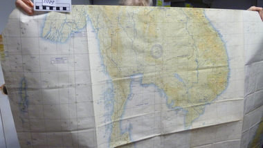 National Vietnam Veterans Museum (NVVM)
Map
Large USAF jet Navigation chart. Scale 1:2,000,000 of South China Seamap, navigation chart -
 Melbourne Tram Museum
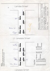
Drawing, Megafun, "Trams on Parade - Swanston St - 13/3/00 - Draft Assembly Map - Schematic Only", 2000
A4 sheet drawing - titled "Trams on Parade - Swanston St - 13/3/00 - Draft Assembly Map - Schematic Only" showing the proposed layout for trams between Lonsdale and Latrobe Street - prepared 2/2/00 by MM (Megafun)trams, tramways, moomba, swanston st, events, parades -
 Wangaratta RSL Sub Branch
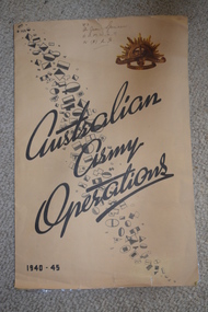
Map, Australian Army Operations 1940-45
Large fold out map and chronology of Australian Army Operations between 1940-1945 that belonged to Private Joan Spencer VFX12932 (VF507134) born 12/11/1924 at Albury. The family moved to Wangaratta and Joan was educated at Wangaratta High School before joining the Australian Army Medical Women's Service at 115 (Heidelberg) Military Hospital. She served with the 130 Australia General Hospital and was deployed overseas to Japan on 17/6/1947 and returned on 26/1/1949Large cream coloured cardboard folded in three, inside is a coloured map of the Middle East 1940-1942, New Guinea Theatre 1942-1944, Pacific Islands 1944-1945 and Malay and Islands 1942-1945. Front cover has Unit patches from top left to bottom right corner , at top right corner is the rising sun badge and bottom left corner 1940-45 Back cover is a listed Chronology.Hand written at top - VFX Pte Joan Spencer AAMWS 115 (H) M.H.australian army operations, private joan spencer, aamws, 130 agh -
 Ringwood and District Historical Society
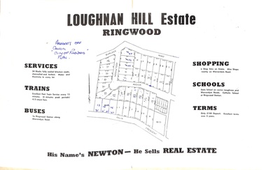
Document - Folder, Subdivision Map - Loughnan Hill Estate, Ringwood, Victoria - circa 1960
Open centre page of land sale brochure glued to manilla folder. Map of residential and shop sites in Burlock Road (later Burlock Avenue), Adolphson Avenue and Felix Crescent, Ringwood, with summary of estate facilities and local services. Agent - T.G. Newton.(Page glued to manilla folder prevents access to front page for further sale information) -
 Bendigo Military Museum
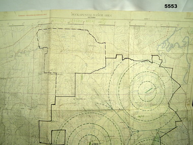
Map - MAP of PUCKAPUNYAL, RAAF et al, 1958
Refer to Cat 5547, Matheson.This is a large map, printed in colour on one side only. Scale 1:25,999. The grid squares are 1000 x 1000 metres. it shows the camp, ranges and bush areas used by the military.This map is covered in a large number of added colour shadings, nav lines, airstrips and circles.puckapunyal army base, military training, map -
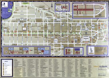 Federation University Historical Collection
Map, Eastern Ballarat (c) Retail and Business Guide, 2004
Map of Ballarat East including Brown Hill, Mount Clear and Buninyong.brown hill, mount clear, mount helen, buninyong, university of ballarat