Showing 993 items
matching paddocks
-
 Eltham District Historical Society Inc
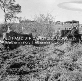
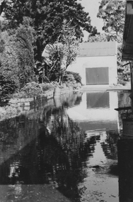
Photograph, Main Road, Eltham South, near Eltham Park, flooded by the Diamond Creek, 30 Nov. 1934
Near Eltham Park (now known as Eltham Lower Park), floodwaters from the Diamond Creek cut off the Main road into Eltham at Bremner’s Flats (present day Wingrove Park). In the distance, left of centre, is Mr. Montieth's Ford Wagonette stranded in the floodwater near Wingrove Cottage. “On the Lower Eltham Reserve the water was nearly five feet deep across the reserve and over a mile along the road. All the week-end shops are surrounded. For over 40 years flood waters have not reached this unprecedented level.” - Advertiser, Friday November 30, 1934, p7 "Whilst we were at the shop a "tidal" wave occured . There used to be a Mr. Monteith who ran a Model T Ford bus from the Eltham Railway Station down the main street. The bus would hold seven, six seated in the back, 3 aside a seventh standing on the step on the middle of the back hanging on to two small hand rails. The bus was caught by the flood and was abandoned not far from our shop in the paddocks towards the Higher Elementary School. It was there for days and after the flood waters receded, Mr. Monteith, after removing all the mud and debris gave the engine one turn with the handle and it started first time! So the story goes! " (Doug Orford Reminiscences, 2004) The 1934 flood of the Diamond Creek and Yarra River is the highest recorded flooding in the district and set the standard for the current planning flood plain level.Black and white photograph showing the floodwater from Diamond Creek across Main Road in 1934. Left of centre shows Mr. Montieth's Ford Wagonette in the floodwater in the distancefloods, main road, eltham south, diamond creek (creek), wingrove cottage, wingrove park, bus services, bremner's flat, eltham park, ford wagonette, mr. montieth, floodwater, reminscences -
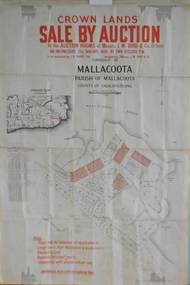 Orbost & District Historical Society
maps, early 1900s
796.1 - Crown Land Sale by auction in the township of Mallacoota on Wednesday January 1920 at 2pm. 796.2 - Snowy River farms , 630 acres of river flat land at Orbost on Wednesday April 28, 1909 at 2.30pm. 796.3 - Famous Orbost Flats - "Important Sale of Snowy River Land" , 900 acres subdivided into 13 choice farms on Wednesday 1st December 1920 at 2.30pm. 796.4 - "Second Great Sale in James' Subdivision", adjoining town of Orbost on 16th May, 1919 at 2pm. 796.5 - "Subdivisional Sale Brooklands Estate", 5 rich Snowy River farms on Wednesday 23rd February at 2.30 at Orbost on account of James Hossack Esq. 796.6 - "Subdivisional sale of Splendid Residence Sites and Handy Small Paddocks" adjoining the progressive town of Orbost on 5th March 1915 at 11am at the rooms of H.James & Co. 796.7 - This is a contract drawing on waxed paper. Crossing near Harbecks Cunninghame Signed and traced N. Anderson 17/11/00. 796.8 - A plan and specification on waxed paper. Shire of Orbost Cunninghame Road - signed by the shire engineer. 796.9 - This is a hand drawn map of Orbost Cunninghame Road, November 1896. 796.10 - This is a hand drawn cross-section of a culvert on the Orbost Cunninghame Road. 796.11 - This is a plan of a culvert on Tabbara Road, 13th January 1899 796.12 - This is a poster for an "Important Subdivisional Sale' for land near Orbost Bridge, on Wednesday 16th March 1921 at the rooms of H. James & Co. These documents are an important part of Orbost history in that they show how the town and surrounding areas were subdivided for farming and residential settlement.A set of twelve maps, plans and land sale posters .orbost-land-1900s maps posters h.james -
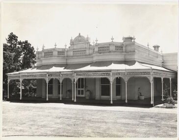 Kew Historical Society Inc
Photograph - 'Wimba', Cotham Road, J E & B L Rogers, c.1965
'Wimba' is of significance as one of the key nineteenth century houses of Kew and for remaining in a substantially intact state. Although probably built some time earlier, the first mention in the Rate Books of the property later known as 'Wimba Lodge' appears in the entry for 1870 when the property, owned by John Sharpe Denbigh, a civil servant, was given an N.A.V. of £72 2. Denbigh did however occupy a house in Cotham Road in 1863, and it is possible that was the same premises'. The house was occupied by Denbigh until at least May 1876 when the 'family residence...' \ 'as auctioned to Carlington George Edmund Marston 5, a chemist of Smith Street, Collingwood. At the time of the auction the house was described thus: The residence and grounds of the late J.S. Dendigh, situate in the most elevated part of Cotham Road Kew. The grounds comprise an area of 4a Or29p or thereabouts, and have a frontage to Cotham-road of 4 chains. The house has two large rooms in front, with 6ft hall built of brick, bay and side windows (plate glass), four rooms of wood behind with slate roofs, bathroom and closets, detached kitchen and servant's room, large shed with washing boiler, pantry and cellar under, brick and cement tank, and the Yan Yean laid onto house and grounds, cowshed, pigstye, &c, the whole securely fenced. First class orchard and flower garden. The paddocks laid with English grasses and drained... .' (Sanderson P, City of Kew Urban Conservation Study, Volume 2, 1988)This work forms part of the collection assembled by the historian Dorothy Rogers, that was donated to the Kew Historical Society by her son John Rogers in 2015. The manuscripts, photographs, maps, and documents were sourced by her from both family and local collections or produced as references for her print publications. Many were directly used by Rogers in writing ‘Lovely Old Homes of Kew’ (1961) and 'A History of Kew' (1973), or the numerous articles on local history that she produced for suburban newspapers. Most of the photographs in the collection include detailed annotations in her hand. The Rogers Collection provides a comprehensive insight into the working habits of a historian in the 1960s and 1970s. Together it forms the largest privately-donated collection within the archives of the Kew Historical Society.The front entrance of Wimba in Cotham Road, Kew. The entrance is flanked by two polygonal bay windows, and a verandah with a concave corrugated iron roof returns around three facades, and accentuates the projections of the windows. The solid render parapet is very ornate and tall for the date of construction. It has panels of decoration along it and is surmounted by a number of render urns. The image was used by Dorothy Rogers in 'A History of Kew' (1973), facing page 144.Wimba ca. 1860 built by J.S. Denbigh (has been altered).wimba, kew, dorothy rogers -
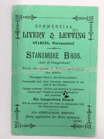 Warrnambool and District Historical Society Inc.
Document, Business Advertising Livery & Letting, 1882
The Warrnambool Amateur Turf Club was first formed in September 1859, but didn't become a properly constituted club until April 1873, when a meeting was held at the Commercial Hotel, now the Whaler's Inn, and a committee was elected.Part of the present racecourse of 100 acres was set aside as a racing and recreation reserve in August 1855. It is one of the finest racecourses in Australia, ringed by the gentle slopes of a huge basin.The first race meeting was held on the course in August 1858. The Warrnambool Racing Club has managed racing at Warrnambool since it was formed on 5 April 1873.Apart from a number of smaller meetings held throughout the year, the feature of racing in the district is the Grand Annual Steeplechase. The first steeplechase over the now famous cross-country course was run on 13th June 1872 then known as the Grand Annual Steeplechase. The paddocks now know as Brierly and Granters were first used on that date. The course, over four miles, was made up of different kinds of jumps including a stone wall, a log fence, a ditch and parapet, a paling fence and numerous post and rails.This card has Warrnambool Racing Club acceptances on one side for the Winter steeplechase meeting for the June meeting in 1882. Stansmore Bros. operated livery stables near the Commercial Hotel in Liebig Street around this time having commenced their business in Camperdown.They later moved to Kepler Street. The Stansmore family had a long association with the racing and agricultural industry in the Camperdown and Heytesbury areas. This little card has links to one of Warrnambool's premier sporting events and a local business which has strong family connections in the district.Small green card with black text on front and back. Edged with small lined border. The back has a racing schedule.Commercial Livery & letting Stables Warrnambool.Stanmore Bros. Warrnambool Racing Club, J.A Archibald Secretary WRCwarrnambool,, commercial livery & letting stables, stansmore brothers stables, warrnambool racing club 1882 -
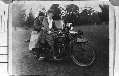 Southern Sherbrooke Historical Society Inc.
Photograph - Two women on a motorcycle
B&W photo shows Cissy Johns and friend on a motorbike at Glen Park Farm, Selby. The photo shows two women in their 20s or 30s, sitting on a motorbike with the registration number 12169. The woman on the right who is most likely Cissie, is sitting astride the bike, holding the handlebars. She is possibly wearing a peaked cap. She has a long knitted jacket over a pale blouse, and a medium coloured skirt which is rucked up by the bike's petrol tank, showing her right leg from the knee down. She has dark stockings and what appear to be medium-heeled, laced shoes with a high shine. The woman on the left is sitting sideways on the pillion seat, with her arms loosely around the first woman's waist. She is wearing a cloche-style hat, a dark knitted v-necked cardigan or jumper, a light-coloured, mid-calf-length skirt, dark stockings and dark shoes with large buckles. Her legs are crossed at the ankles. Both women are smiling at the camera. The windscreen of a sidecar is visible. They are in a cleared paddock with a wire fence and trees in the background. n.d. -
 University of Melbourne, Burnley Campus Archives
Album, Sandra Pullman, National Estate/Heritage Register Photographs, 2001
Photograph Album sent in with the National Estate/Heritage Register by Sandi Pullman. (1) Old car park (Bull Paddock) with Cork Oak. (2) Main Building front steps. (3) Main Building with Magnolia grandiflora. (4)View of Luffmann Ponds and old willow. (5) View of Ginkgo and Emily Gibson bed. (6) Looking between Emily Gibson beds to English Oak. (7) Summer House. (8) Luffmann Ponds. (9) Bergenia Walk with conifers. (10) View of Pencil Pines around entrance to Sunken garden. (11) Luffmann Ponds and Pinus canariensis. (12) View of entrance to Sunken garden. (13-14) Sunken garden. (15) Original terracing at entrance to Shady Walk. (16) Pears in blossom in Field Station. (17) Agathis robusta from the Herb Garden. (18) Ellis Stones Rock garden newly replanted. (19) james Hitchmough Grasslands. (20) Elm tree with Dairy in the background. (21) Original Red Gum in james Hitchmough Grasslands. (22) Kath Deery Native garden. (23-24) Rose Garden. (25) Sequoiadendron giganteum.national estate, heritage register, sandi pullman, sandra pullman, bull paddock, cork oak, magnolia, luffmann ponds, willow, ginkgo, emily gibson bed, english oak, summer house, bergenia walk, conifers, pencil pines, sunken garden, pinus canariensis, shady walk, pears, blossoms, field station, agathis robusta, herb garden, ellis stones rock garden, james hitchmough grasslands, elm tree, dairy, red gum, kath deery native garden, rose garden, sequoiadendron giganteum. -
 Wodonga & District Historical Society Inc
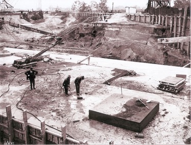
Album - Hume Reservoir Australia Album - Preparing a paddock for concrete. August 1927
This set of photos is from a leather bound album bearing the inscription "HUME RESERVOIR AUSTRALIA" plus 'The Rt. Hon. L. C. M. S. Amery, P. C., M .P.' all inscribed in gold. It was presented to The Rt. Hon. L. C. M. S. Amery, P. C., M. P, Secretary of State for Dominion Affairs on the occasion of his visit to the Hume Reservoir on 2nd November 1927. This album is of local and national significance as it documents the planning and development of the Hume Reservoir up to 1927. It was the largest water reservoir in the British Empire. The album records the pioneering engineering work that went into its construction.DEPARTMENT OF PUBLIC WORKS, N.S.W. RIVER MURRAY WATERS SCHEME. HUME RESERVOIR. 27. Preparing a Paddock for Concrete. Great care is taken in cleaning the surface of the concrete before placing the next layer. A hose applies a jet of water with a pressure of about 150 pounds to remove laitance and all dirt, which is swept off with brooms. (Laitance is the weak, milky or powdery layer of cement dust, lime and sand fines that appear on the surface of concrete. ) The square block of concrete in the foreground is poured at the same time as the concrete surrounding it and acts as a key for the next layer. Usually large granite “plums” or displacers weighing from 2 tons to 8 tons are used for this purpose and are placed in position by the cableway, but while the cableway is out of action the other method has been adopted. In this view may also be seen some of the timber piles and sheeting which form the inner side of the coffer dam. The outer side is formed of steel sheet piling. The space between the two lines of piles is 20 feet wide and is filled with earth after the steel and timber lines have been bound together by steel tie rods. New South Wales, August 1927.hume reservoir australia, river murray waters scheme, hume reservoir construction -
 University of Melbourne, Burnley Campus Archives
Album - Colour prints, Photograph Album Burnley College Buildings, 1981-1985
Collection of 34 photographs in a cardboard photograph album with plastic pages. Most stamped 20 Aug 1985 on reverse, Quad construction 1981.(1) Administration Building front entrance. (2) Administration Building front view. (3) Administration Building front centre. (4) Administration Building, back entrance, Hall end. (5) Administration Building, back centre. (6, 7) Student Amenities Building. (8) Quad 5. (9, 10) Library, front completed 1982. (10A) Library, back. (11) Nursery. (12) Nursery (13,14) Quads 2,3,4. (15) Quad 6 back. (16) Engineering (17) Library front from the Bull Paddock. (18) Dairy. (19) Principal's Garage, now Herb Garden. (20) Soil Bins old Nursery. (21) Old Nursery. (22) Greenhouse old Nursery. (23-25) Landscape Shed. (26) Orchard Shed. (27) Orchard Shed and Kiwi Fruit vine. (28,29) Plant Science Laboratory. (30) Energy Efficient Glasshouse old Nursery. (31) Glasshouse old Nursery and Potting Shed. (32) Energy Efficient Greenhouse old Nursery. (33) Potting Shed old Nursery.quad construction, administration building, student amenities, library, nursery, bull paddock, dairy, principal's garage, herb garden, soil bins, greenhouse, landscape shed, orchard shed, kiwi fruit vine, plant science laboratory, energy efficient glasshouse, potting shed -
 Eltham District Historical Society Inc
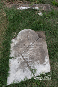
Photograph, Peter Pidgeon, Grave of Peter Lawlor and children, Eltham Cemetery, Victoria, 5 April 2021
The Victorian gold rush came to Eltham in the early 1850s and with it came a crime wave. Local traders called for police protection. This led to the appointment in 1857 of Irish-born Peter Lawlor as Senior Constable at Eltham. In 1859 Peter and his wife Kate were able to move into an official police residence at the corner of Maria Street (now Main Road) and Brougham Street, with stables out the back and a large paddock for grazing across the road. Some of their children went to Eltham Primary School. That 1859 police residence is now the home of the Eltham District Historical Society. The small wooden building on the very corner is a modern replica of the separate police station/office built around 1885-1900. Cases investigated by Constable Lawlor included murders, stealing (horses, cattle, fowls, watches, linen, clothing), a search for a missing person, and two separate instances of abandoned children seeking help. He was officially commended in 1866 for bringing to justice a man who had indecently assaulted an 11-year old girl. Sadly, there was a similar but unconnected case only a few months later. But events had a lighter side; in 1871 Kate lent her piano to the Snowflakes Christy Minstrels for a Catholic Church fund-raising concert. Peter was transferred to Prahran in 1872. He died in 1876 and is buried in Eltham Cemetery with four of his children. His headstone was stolen some time after May 1990 but was returned anonymously (broken into three pieces) in August 2013. It is resting on his grave but has not been re-erected. The Inscription reads: Peter Lawlor Who died February 12th 1876 Aged 55 years Also his children Michael Margaret Maud and EdithBorn Digitaleltham cemetery, gravestones, edith lawlor, margaret lawlor, maud lawlor, michael lawlor, peter lawlor -
 Orbost & District Historical Society
ledger, 1911-1914
This ledger was used by the Shire of Orbost from 1911 - 1914. It was used to record fees paid for Dairy Registration, Dog Registration and Sheep dipping. At that time dairy farmers were required to register all milking cows. Dogs, too, were to be registered and there were strict laws on sheep dipping. Every sheep-owner was to dip all his sheep immediately after shearing and directly from the shearing-board in every year and also at the time of dipping his sheep dip all his lambs. In case the sheep couldn't be conveniently dipped directly from the shearing board they were to be placed and kept in a securely fenced paddock to be dipped within sixty days after shearing. Sheep-owner who neglected or failed to comply with any of these directives were liable to a penalty of not less than One pound nor more than Twenty pounds. The shire covered an area of 9,347 square kilometres and existed from 1892 until 1994 when it became part of the East Gippsland Shire Council. Orbost was at first included in the Bairnsdale Shire from 1882 and was later part of the Tambo Shire. Because of travelling distances the Croajingalong Shire was created in 1892 (name changed to Orbost Shire 17.2.1893 with James Cameron as the first Shire President. In 1994 it amalgamated to become part of East Gippsland Shire Council. The item was donated to Orbost & District Historical society from P.R.O.V. as a Place of Deposit (POD) item for safe keeping by a local history group or museum. The shire covered an area of 9,347 square kilometres and existed from 1892 until 1994 when it became part of the East Gippsland Shire Council. This item is a record of local council accounting. The Shire of Orbost no longer exists as it was absorbed by the East Gippsland Shire Council.A dark blue, leatherette covered ledger cash book with tan spine, stitched marbled end covers. Records are handwritten in blue and red ink and blue pencil. It contains records of Dairy Registration fees, Dog Registration fees and Sheep Dipping fees.Inside the front cover is a list of contents.ledger orbost-shire-council sheep-dipping dairy-registration accounts -
 University of Melbourne, Burnley Campus Archives
Letter - Photocopies and photograph, 1927-1930
1200 2 pages of Notes, written by C French Senior to the Jessep Esq. Starting with Royal Horticultural Society 1855, in Survey Paddock. Purpose of establishment of this enterprise; Committee men: The planting by C French of Taxodium Sempervirens: a great flood and its destruction of the Burnley Gardens: this letter is handwritten. A note from C French, dated 23/5/1929, adds further information to the notes. States that Burnley Gardens were laid out by M Lynch and W Harbison as curator. 1201 Handwritten letter by C French to Charlie, thanking him for sending a copy of an article from The Sun. He comments on omissions from the article, provides names of men involved in the first years of the development of the B Gardens, says a good deal about G Neilson. 2 pages. 1202 Letter addressed to Director Botanical Gardens. Refers to a W. Ward, a horticulturalist and the willow tree Huntingdon Willow - Salix Alba (coerulea) Letter written by Charles French. States that willows were sent to Bot Gardens by Sir Joseph Hooker of Kew. The use of this for cricket bats. Willows being setn to Victorian nurseries in 1850s from England. CF States that he planted the first tree Taxodium sempervirens, in Burnley Gardens. Tree presented by JJ Rule of Richmond. 2 pages. 1203 Letter to Charlie from Charles French, signed also Dad This letter is said to be accompanying notes on the B Gardens (Burnley or Botanic?) 1204 Letter to Jessep from Charles French. Mention of "Sequoia" sempervirens Endlicher the red wood planted at Burnley. 1 page5 letters from Charles French about early history of Burnley gardens- Refer to paper cataloguecharles french, gardens, sequoia, redwood, willow tree, use of willow for cricket bats, willow cricket bats, cricket, huntingdon willow, flood burnley gardens -
 Eltham District Historical Society Inc
Negative - Photograph, J.A. McDonald, Kangaroo Ground-Queenstown Road, Aug. 1960
(Kangaroo Ground-St Andrews Road) “Rymers” Corner – shifting Hawthorn hedges on Tompkins property Council’s Drott 6 Woods Drott 9 August 1960 Showing hedge in rear already transported EDHS_05569-55 (EDHS_05577-3/4) and EDHS_05569-56 (EDHS_05577-5/6) - Hawthorn Hedges, Kangaroo Ground 50-50 ELTHAM, CUT THE HEDGES! While all of us are talking about the road toll, Eltham Council must have been in long recess. Around Kangaroo Ground are farmers’ hawthorn hedges shrouding dangerous corners on busy roads. If the council does not insist on their removal for a distance clear enough for safe driving, then it must be held culpable for the accidents that are bound to happen. – WAKE UP (Melbourne) ELTHAM, CUT THE HEDGES! 50-50 (1960, 6 January), The Sun (News clipping held in SEA_74-1_007) ‘BAD HEDGES’ WILL GO “We know there are some bad hedges on corners in the Kangaroo Ground area, but roadworks this year will eliminate them,” the Eltham Shire secretary, Mr Maxwell B. Watson, said yesterday. A reader in 50-50 yesterday complained of farmers’ hawthorn hedges obscuring drivers’ views at bad corners on busy roads in the Kangaroo Ground district. Mr Watson said the roadworks were deviations to remove the sharp turns, and the road would cut back into paddocks. The hedges would go at the same time. Meanwhile, the shire had power to require owners to cut back hedges, and this would be done if specific instances were reported and found justifiable. ‘BAD HEDGES’ WILL GO (1960, January 7), The Sun (News clipping held in SEA_74-1_007)Record of various Shire of Eltham infrastructure works undertaken during the period of 1952-1962 involving bridge and road reconstruction projects, sometimes with Eltham Shire Council Project Reference numbers quoted. It was during this period that a number of significant improvements were made to roads and new bridges constructed within the shire that remain in place as of present day (2022). In many situations, the photos provide a tangible visible record of infrastructure that existed throughout the early days of the Shire. The album was put together by or under the direction of the Shire Engineer, J.A. McDonald.infrastructure, shire of eltham, 1960-08, garden hill, kangaroo ground, kangaroo ground-queenstown road, kangaroo ground-st andrews road, rymers corner, bulldozer, drott -
 Eltham District Historical Society Inc
Negative - Photograph, J.A. McDonald, Kangaroo Ground-Queenstown Road, Aug. 1960
(Kangaroo Ground-St Andrews Road) “Rymers” Corner – shifting Hawthorn hedges on Tompkins property Council’s Drott 6 Woods Drott 9 August 1960 Showing method of lifting clumps of Hawthorn EDHS_05569-55 (EDHS_05577-3/4) and EDHS_05569-56 (EDHS_05577-5/6) - Hawthorn Hedges, Kangaroo Ground 50-50 ELTHAM, CUT THE HEDGES! While all of us are talking about the road toll, Eltham Council must have been in long recess. Around Kangaroo Ground are farmers’ hawthorn hedges shrouding dangerous corners on busy roads. If the council does not insist on their removal for a distance clear enough for safe driving, then it must be held culpable for the accidents that are bound to happen. – WAKE UP (Melbourne) ELTHAM, CUT THE HEDGES! 50-50 (1960, 6 January), The Sun (News clipping held in SEA_74-1_007) ‘BAD HEDGES’ WILL GO “We know there are some bad hedges on corners in the Kangaroo Ground area, but roadworks this year will eliminate them,” the Eltham Shire secretary, Mr Maxwell B. Watson, said yesterday. A reader in 50-50 yesterday complained of farmers’ hawthorn hedges obscuring drivers’ views at bad corners on busy roads in the Kangaroo Ground district. Mr Watson said the roadworks were deviations to remove the sharp turns, and the road would cut back into paddocks. The hedges would go at the same time. Meanwhile, the shire had power to require owners to cut back hedges, and this would be done if specific instances were reported and found justifiable. ‘BAD HEDGES’ WILL GO (1960, January 7), The Sun (News clipping held in SEA_74-1_007)Record of various Shire of Eltham infrastructure works undertaken during the period of 1952-1962 involving bridge and road reconstruction projects, sometimes with Eltham Shire Council Project Reference numbers quoted. It was during this period that a number of significant improvements were made to roads and new bridges constructed within the shire that remain in place as of present day (2022). In many situations, the photos provide a tangible visible record of infrastructure that existed throughout the early days of the Shire. The album was put together by or under the direction of the Shire Engineer, J.A. McDonald.infrastructure, shire of eltham, 1960-08, garden hill, kangaroo ground, kangaroo ground-queenstown road, kangaroo ground-st andrews road, rymers corner, bulldozer, drott -
 Eltham District Historical Society Inc
Negative - Photograph, J.A. McDonald, Kangaroo Ground-Queenstown Road, Aug. 1960
(Kangaroo Ground-St Andrews Road) “Rymers” Corner – shifting Hawthorn hedges on Tompkins property Council’s Drott 6 Woods Drott 9 August 1960 EDHS_05569-55 (EDHS_05577-3/4) and EDHS_05569-56 (EDHS_05577-5/6) - Hawthorn Hedges, Kangaroo Ground 50-50 ELTHAM, CUT THE HEDGES! While all of us are talking about the road toll, Eltham Council must have been in long recess. Around Kangaroo Ground are farmers’ hawthorn hedges shrouding dangerous corners on busy roads. If the council does not insist on their removal for a distance clear enough for safe driving, then it must be held culpable for the accidents that are bound to happen. – WAKE UP (Melbourne) ELTHAM, CUT THE HEDGES! 50-50 (1960, 6 January), The Sun (News clipping held in SEA_74-1_007) ‘BAD HEDGES’ WILL GO “We know there are some bad hedges on corners in the Kangaroo Ground area, but roadworks this year will eliminate them,” the Eltham Shire secretary, Mr Maxwell B. Watson, said yesterday. A reader in 50-50 yesterday complained of farmers’ hawthorn hedges obscuring drivers’ views at bad corners on busy roads in the Kangaroo Ground district. Mr Watson said the roadworks were deviations to remove the sharp turns, and the road would cut back into paddocks. The hedges would go at the same time. Meanwhile, the shire had power to require owners to cut back hedges, and this would be done if specific instances were reported and found justifiable. ‘BAD HEDGES’ WILL GO (1960, January 7), The Sun (News clipping held in SEA_74-1_007)Record of various Shire of Eltham infrastructure works undertaken during the period of 1952-1962 involving bridge and road reconstruction projects, sometimes with Eltham Shire Council Project Reference numbers quoted. It was during this period that a number of significant improvements were made to roads and new bridges constructed within the shire that remain in place as of present day (2022). In many situations, the photos provide a tangible visible record of infrastructure that existed throughout the early days of the Shire. The album was put together by or under the direction of the Shire Engineer, J.A. McDonald.infrastructure, shire of eltham, 1960-08, garden hill, kangaroo ground, kangaroo ground-queenstown road, kangaroo ground-st andrews road, rymers corner, bulldozer, drott -
 Federation University Historical Collection
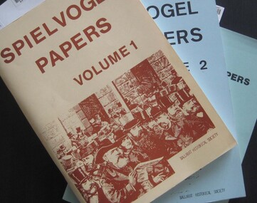
Booklets, Ballarat Historical Society, Spievogel Papers, volumes 1,2, & 3
Nathan Spielvogel was a local historian. The Spielvogel Papers consist of the articles he prepared for a series of weekly talks on Radio 3BA in 1936 and 1937. According to Alex Barnett there is a reference in the Spielvogel Papers to the moving of the bodies of diggers killed at the Eureka Stockade to the old cemetery on 26 November 1857.3 soft covered books with text relating to the history of Ballarat. .1) yellow cover .2) blue cover .3) green cover .1) includes topics such as Gold discovery, Eureka, Main Road, Ballarat Fire Brigade, Ballarat Benevolent Home, Buninyong, Burke and Wills Monument, Chinese in Ballarat, Dana Street School, Ballarat Hospital, Lost Trades of Ballarat, Ballarat Military, Mount Pleasant, Old Colonists' Club, Phoenix Foundry, Ballarat Post Office, Railways, Ballarat School of Mines, South Street Society, Martin Hosking, Charles Curnow Phillips, James Sainsbury, and William Cross Yuille. .2) includes topics such as Ballarat streets, bowls, cricket, football, hotels, Little Bendigo, Lake Wendouree, Ballarat Quartz Mines, Sebastopol, Ballarat Turf Club, Ballarat Zoo, water supply. .3) includes topics such as the Kohinoor Nugget, Eureka, Black Hill, Sebastopol, oddietown, Joe the bellman, Trades Hall, Lal Lal Iron, Ballarat Library, Yuille Creek, Martin Hosking, Stonewall Jackson, steeplechase, Lemonade Paddock, Ivey's Flour Mill, Salvation Army, Stick Jaw Davey, Unicorn Hotel, doctors, Alfred Bells, Ballarat School of Mines Museum (War Museum), Joseph Orange, Ballarat East Post Office.ballarat, speilvogel, nathan spielvogel -
 Federation University Historical Collection
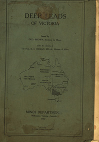
Book, Mines Department, Victoria, Deep Leads of Victoria, 1937, 1937
Charcoal green soft covered book of 64 pages. Contents include Ballarat, berry Consols, Canadian Lead, Castlemaine-Daylesford System, Chiltern, Duke of Cornwall Mine, Dyke's Freehold, Frenchman's Lead, Garibaldi Shaft, Glenfine, Guidlford, Hepburn Estate Co., Hepburn Home Paddock, Italian Gully, Henderson's Lead, Langi Logan, Leigh Consols, Sebastopol Plateau; Talbot, Woady Yalloak, A definition of a deep lead, formation of deep leads, water in deep leads, methods of deep lead mining (Tunnelling, Deep sinking, Chiltern method of working, Ballarat method of working), sampling washdirt and gravels, Balmoral, Mt William, Stawell, Moyston, Great Western, Ararat, Raglan, Wimmera Valley, Landsborough, Cardigan, Haddon, Beaufort, Waterloo, Avoca, Lamplough, Caralulup, Ballarat West, Ballarat, Smythesdale, Glenfine, Illabarook, Durham Lead, Morrison's Lead, Bullengarook, Berry-Moolort-Loddon System, Clunes, Creswick, Spring Hill, Bullarook, Castlemaine - Daylesford, Majorca, Carisbrook, Timor, Burnt Creek Tributary, Tarnagulla, Marong, Rheola, Inglewood, Huntly, Coliban, Campaspe, Goulburn Lead System, Ovens Valley System, Mitta Mitts, Kiewa Valley, Tarago, Tanjil, Moondarra, Bogong, Dargo High Plains, glossarymining, deep leads, mines department, squire, leigh consols, chiltern, duke of cornwall mine, dyke's freehold, frenchman's lead, garibaldi shaft, glenfine, guidlford, hepburn estate co., hepburn home paddock, italian gully, henderson's lead, langi logan, sebastopol plateau, talbot, woady yalloak, tunnelling, deep sinking, chiltern method of working, ballarat method of working, sampling washdirt. gravels, balmoral, mt william, stawell, moyston, great western, ararat, raglan, wimmera valley, landsborough, cardigan, haddon, beaufort, waterloo, avoca, lamplough, caralulup, ballarat west, ballarat, smythesdale, illabarook, durham lead, morrison's lead, bullengarook, berry-moolort-loddon system, clunes, creswick, spring hill, bullarook, castlemaine - daylesford, majorca, carisbrook, timor, burnt creek tributary, tarnagulla, marong, rheola, inglewood, huntly, coliban, campaspe, goulburn lead system, ovens valley system, mitta mitta, kiewa valley, tarago, tanjil, moondarra, bogong, dargo high plains -
 Eltham District Historical Society Inc
Negative - Photograph, Tom Prior, Main Road near Eltham Railway Station, c.1910
View looking south along Main Road, Eltham from near present day Luck Street. On the immediate right is a fence with the words “Hot Water” painted on it followed by William J Capewell’s butcher shop, then the slaughter yard and saleyards with the entrance access to the railway station. Contained within the saleyards facing the street, a small shelter with the name H.H. Clark upon it. Horace Harold Clark was the son of Eltham State School’s first Head Teacher, David George Clark. As well as being a farmer, he was an Estate Agent and conducted auction sales, presumably from this shelter. The large weatherboard building on the corner (opposite present-day Arthur Street) with signs for Summer Drinks and Hot Water painted on the side is Luther and Ada Haley’s General Store and Bakery, built 1902. This was the first building in what is now Eltham’s present shopping town centre. Haley previously ran the General Store and Bakery on the corner of Main Road and York Street until his lease expired and the premises were bought by Mrs Sarah Burgoyne in 1902. The store later was known as Staff's Store. In the distance approximately mid-way between the Butcher shop and the Bakery are the tops of what appears to be two cypress trees, which could well be the trees in front of the Shillinglaw Cottage facing Main Road. On the eastern (left) side of Main Street is Haley’s Paddock, which was used on occasions for community picnics. Capable of holding 10,000 people, with ample shade and hilly surroundings it was an ideal place for any community gathering such as the State Schools’ Picnic in 1904. Picture dated as c.1910 based on similar picture published in the Weekly Times, Feb. 1912. Kerb and channelling added 1923. Cross Ref: 610 (looking north), 611 (later stage), 613. Same as 705 (though in better condition)This photo forms part of a collection of photographs gathered by the Shire of Eltham for their centenary project book,"Pioneers and Painters: 100 years of the Shire of Eltham" by Alan Marshall (1971). The collection of over 500 images is held in partnership between Eltham District Historical Society and Yarra Plenty Regional Library (Eltham Library) and is now formally known as the 'The Shire of Eltham Pioneers Photograph Collection.' It is significant in being the first community sourced collection representing the places and people of the Shire's first one hundred years.Digital image 4 x 5 inch B&W Neg 120 format B&W negative (spare)shire of eltham pioneers photograph collection, eltham, main road, butcher, eltham railway station, railway station, w.j. capewell, baker, eltham town centre, general store, luther haley, reynolds prior collection, shops, haley's paddock, hot water, m.m. clark, sign, summer drinks, eltham sale yards, eltham slaughter yard, staffs general store -
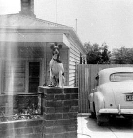 Surrey Hills Historical Society Collection
Photograph, 55 Sunbury Crescent, Surrey Hills - Home of Fred Lyons and his family
This was the home of Fred Lyons and family from c1920. Previously they had lived in Lorne Parade. Fred had a hansom cab at the rank at the Surrey Hills station from c1919 and stabled his horse in a paddock to the rear of this house. His son Arthur Lyons remained living here until 1990. The fox terrier was Fred's constant companion. This is one of a series of photos donated by Arthur Lyons. From 1907 a cab service operated from near the railway gates in Union Road. It was established and maintained by Mr C Fraser until c1916. George Rea either took over then or set up in opposition. Fred Lyons initially worked for George until he set up his own business. In time he changed over to a motor vehicle and continued his service until 1960. Frederick Adolphus Lyons (1891-1980) was born in Surrey Hills, son of Thomas and Catherine Lyons. He married Elizabeth Ruby Hall in 1918. They lived in Lorne Parade before moving to 55 Sunbury Crescent. The Lyons’ home in Sunbury Crescent was called ‘Knopshambury’ - this was probably a misspelling of Knockshanbally in Co Kilkenny, the birth place of Fred’s father, Thomas Edmund Josias Lyons (1846-1915). Arthur Lyons was born in Surrey Hills on 12 Jun 1920. He became a motor mechanic / welder and lived his whole life at 55 Sunbury Crescent. The donation was made while he was in hospital. He died shortly afterwards (23 Sep 1990). Donation was finalised by a neighbour, Mrs Florence Ann Armitstead, wife of Glen Victor Armitstead. Glen was a local hairdresser. They moved to 11 Sunbury Crescent after their marriage in 1939. Arthur had no relatives to distribute the material to.Black and white photo of the home of Fred Lyons and his family. It is a simple timber cottage with a corrugated iron roof and a low brick fence with wrought iron decorative infill between the brick pillars. A fox terrier sits on the brick pillar next to the driveway. On the RHS of the house a high slatted timber fence divides the front from the rear of the property. An early model Holden is parked in the driveway, the number plate beginning with GBEOn the back in pencil "copied 1996" . In black pen "Lyons, Sunbury Cres" timber cottages, arthur lyons, arthur frederick lyons, fred lyons, frederick adolphus lyons, elizabeth ruby hall (miss), elizabeth ruby lyons (mrs) -
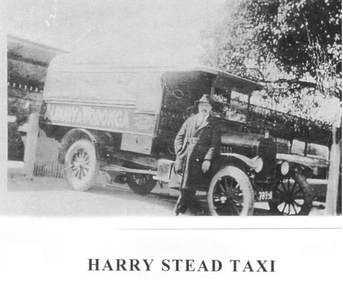 Wodonga & District Historical Society Inc
Photograph - Harry Stead Taxi Service
Harry Stead, Snr., owned and operated Wodonga’s first taxi service. He had horse drawn cabs running between Wodonga, and Albury in 1868. He also ran a carrying business with wagons and drays. Workmen from Albury and Wodonga were carried to the construction site of the Hume Weir. Drays, although slow, were used with room for 10 or 12 paying passengers, at times. Stead’s paddocks ran back from Sydney Street (now High Street) with stable accommodation for his 70 and more horses. The Provincial Motel occupied part of the site in later years. Harry’s son, “young Harry” joined his Dad around 1892 as soon as his schooldays were over. After the horse drawn cabs, the Steads began a motorised taxi, hire car and bus services. Some of the taxis used were an A-Model Ford, 1934 Ford, Ford V8, Dodge Tourer, Hudson Six and, earlier, the 1923 Buick with dicky seat. Among the drivers were Stan Hogbin, Gerry Gerrard, Jack O’Neill, “Peggy” O’Neill, Ernie “Honey” Zeinert, Cliff Williams and Les Cole. Young Harry had four cars on the rank from 1930 to 1940 when competition for fares was fierce. He had his regulars who paid 4/- a week to go to and from Albury daily. In 1934, Harry was before the Albury Police Court, charged with having driven his taxi on a public road without a taxi licence. The Albury Municipal Council required all taxi drivers to have a NSW certificate of registration before collecting fares in NSW. The case was held as a test case and as a result the regulation was amended to enable the Council to issue public vehicle licenses to a Victorian registered vehicle as long it travelled no more than 10 miles over the border.These images are significant because they document an early transport service provided to the Wodonga community.Three black and white photos depicting Harry Stead and his Wodonga Taxi Service.harry stead wodonga, transport wodonga, wodonga services -
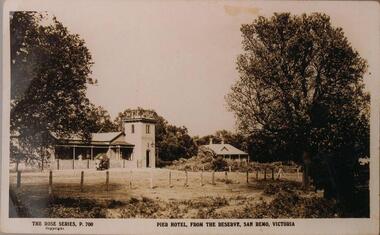 Phillip Island and District Historical Society Inc.
Photographs, 1940's to 1960's
Part of a collection of photographs donated by Bruce Bennett. Photographs from collections of: David Johnson, I Mannix, Legg, Charlie Blackney, Des Chilcott, Ted Walton, Len Bagley and Brian Davis.233-20. Black & White photograph of a postcard. The Pier Hotel and house set in paddock and surrounded by large trees and reserve at San Remo, Victoria. 233-21. Black & White photograph of a photograph. Bentons Guesthouse, San Remo, Victoria. 233-22. Black & White photograph of a photograph. Herbie Kirkland or Clive Fox?? on barge at Newhaven, showing cray caufs lined up on jetty in the background. 233-23. Black & White photograph of a photograph. San Remo Hotel. 233-24. Black & White photograph of a photograph. Breakwater at San Remo circa 1940 with family on the beach (Bert Blackney & Violet) and people swimming. Wooden groyne in foreground. 233-25. Black & White photograph of a photograph. Building the slip at Newhaven, Phillip Island. 233-26. Black & White photograph of a photograph. House in the distance at Rhyll built by Johnson. Dan Patience lived there till 1950's then Ted Walton. 233-27. Black & White photograph of a photograph. San Remo to Newhaven, Phillip Island punt with 3 cars on board. 233-28. Black & White photograph of a photograph. San Remo jetty showing boats and sheds. Ivan Hayhow boat. 233-29. Black & White photograph of a photograph. Sailing boat on Westernport with Phillip Island Suspension bridge behind.233-20 The Rose Series P700. Pier Hotel, from the reserve, San Remo, Victoriahotels, pier hotel san remo victoria, san remo hotel victoria, bentons guesthouse san remo, guesthouses, san remo to newhaven barge, phillip island barge, newhaven barge, san remo beach, newhaven slip phillip island, rhyll phillip island, san remo punt, san remo jetty, phillip island suspension bridge, sailing boats, bruce bennett -
 Kiewa Valley Historical Society
Alex McCullough Collection - Notes and Photos on History of Mt Beauty
Alex McCullough was a resident of Mt Beauty for many years and wrote a book on the History of Mt Beauty. Mt Beauty was constructed by the State Electricity Commission of Victoria to house employees working on the Kiewa Hydro Electric Scheme. Alex was involved with many organisations in Mt Beauty and interested in history. He took many photos of events and new developments in town. He also collected individuals memoirs on life in the town.Mt Beauty's history is unique as it was built as a construction town in the late 1940s. The information in Alex's Collection records the town's development perhaps in more detail than in his book "The History of Mt Beauty". His folder includes his education, his work with the SECV (foreman working on Clover Dam), his war service, his community work (Mt Beauty & District Progress Association & Mt Beauty Neighbourhood Centre) and awards, work as Shire Councillor and Mayor, sporting (tennis & golf) interests. Alexander John McCullough 1916 - 2011's obituary is online ref. legacy.comA) Booklet - The Life of Alex McCullough B) Booklet - The Story of Kiewa by Alex McCullough C) Coloured photos 15cm x 10 cm of the renovation of the Mt Beauty Neighbourhood Centre mid 2001. Four photos are labelled by Alex McCullough on the back. Also, photos of various sizes both colored and black and white depicting sites and people in Mt Beauty. Not labelled.Also, six packets of negatives of older photos incl. Community Hall, Fire Brigade, School, School ski group, Back to Kiewa, Alpine Study, D) Alex McCulloughs 1951 Diary - Clover Dam E) Random Items from History Profile Kiewa by Alex McCullough F) Papers - 'Administration of Mt Beauty Township' - 2nd July 1957. SECV buildings in Mt Beauty shared with community groups notes re - arrangement between groups. G) Barrie Wilcox's Memories living in Marum's paddock from c1940s onwards. Written in June 1999 H) Mt Beauty website June 1998 - a lot of history I) Papers - Mt Beauty High School band developement J) The 1950s Development of the Birth of Community support organisations K) Community Centre Mt Beauty opening 3rd August 1951 L) Mt Beauty Fire Brigade History M) Folder Personal papers re Alex McCullough alex mccullough, mt beauty history, community work -
 Kew Historical Society Inc
Plan, Melbourne & Metropolitan Board of Works : Borough of Kew : Detail Plan No.1576, 1904
The Melbourne and Metropolitan Board of Works (MMBW) plans were produced from the 1890s to the 1950s. They were crucial to the design and development of Melbourne's sewerage and drainage system. The plans, at a scale of 40 feet to 1 inch (1:480), provide a detailed historical record of Melbourne streetscapes and environmental features. Each plan covers one or two street blocks (roughly six streets), showing details of buildings, including garden layouts and ownership boundaries, and features such as laneways, drains, bridges, parks, municipal boundaries and other prominent landmarks as they existed at the time each plan was produced. (Source: State Library of Victoria)This plan forms part of a large group of MMBW plans and maps that was donated to the Society by the Mr Poulter, City Engineer of the City of Kew in 1989. Within this collection, thirty-five hand-coloured plans, backed with linen, are of statewide significance as they include annotations that provide details of construction materials used in buildings in the first decade of the 20th century as well as additional information about land ownership and usage. The copies in the Public Record Office Victoria and the State Library of Victoria are monochrome versions which do not denote building materials so that the maps in this collection are invaluable and unique tools for researchers and heritage consultants. A number of the plans are not held in the collection of the State Library of Victoria so they have the additional attribute of rarity.Original survey plan, issued by the MMBW to a contractor with responsibility for constructing sewers in the area identified on the plan within the Borough of Kew. The plan was at some stage hand-coloured, possibly by the contractor, but more likely by officers working in the Engineering Department of the Borough and later Town, then City of Kew. The hand-coloured sections of buildings on the plan were used to denote masonry or brick constructions (pink), weatherboard constructions (yellow), and public buildings (grey). Development in the 20th century has irreparably altered that part of Kew represented in this plan. In the block bounded by Cotham Road, Charles Street, Wellington Street and Gellibrand; just one house standing in 1903 remains. This block included two of the most historic houses in Kew: ‘Ordsall’ (later ‘Southesk’) and ‘Madford’ (previously ‘Elm Lodge’). Ordsall was the home of the second chairman of Kew, John Halfey. It contained some of the most significant interior murals in Kew, created for Halfey by artists working for Cullen & Co. It was demolished in 1960 to make way for the Kew Civic Centre. Elm Lodge had been built for William Siddeley in ca. 1864. Arthur Septimus King purchased it in 1874. The lower paddocks of Madford were sold in 1905 by his wife to the Borough of Kew and, after landscaping by George and Thomas Pockett, opened as the Alexandra Gardens in 1908. Elm Lodge/Madford was in 1922 to become St. Anthony’s Home for Little Children before its subsequent demolition in the 1980s.melbourne and metropolitan board of works, detail plans, maps - borough of kew, mmbw 1576, cartography -
 University of Melbourne, Burnley Campus Archives
Album - Colour prints, Stuart Miller, Garden Views, 1983
Colour photographs. (1) Herbaceous Border 1984-5 (pre-Rainforest) #277. (2) View Admin Building from between Emily Gibson Beds. (3) Admin Building. (4) View of Bull Paddock, Dairy and beyond from roof of Admin Building. (5) Rear of Burnley. Tennis Court replaced by PSL 4-6 (DA) (6) Shady Walk Mondograss (Ophiopogon japonicus) Umbrella Grass (Cyperus alternifolius) (David Aldous). (7) Admin Building and Student Amenities Building. (8-10) Luffmann Ponds. (11) Frank's/Rock Point. (12-13) Oak Lawn. (14) Oak Tree lawn on reverse "Please return to Stuart Miller, Burnley College." (15) E. cladocalyx. (16) The Victorian College of Agriculture & Horticulture-Burnley Campus. U. procera to the left E. cladocalyx to the right DA. (17) Sugar Gum E. cladocalyx Burnley Gardens 1989 DA. (18) Burnley College in background DA Crack Willow in winter. (19) Tree unidentified. DA (20) DA View of trees behind Luffmann Ponds. (21) View of Burnley Gardens Pinus canariensis to the left Agathis robusta centre and sequoia sempervirens to the right DA. (22) Students in Citriodora Courtyard. (23) View of Emily Gibson Beds from roof of Admin Building. (24) Admin Building from Oak lawn. Annotated by David Aldous and Stuart Miller. herbaceous border, administration building, emily gibson beds, bull paddock, dairy, tennis court, shady walk, luffmann ponds, oak lawn, david aldous, stuart miller, student amenities building, sugar gum, citriodora courtyard, lily ponds -
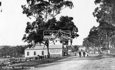 Eltham District Historical Society Inc
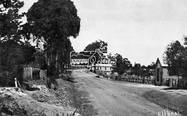
Photograph, Eltham, Main Road near station, c.1910
View looking north along Main Road, Eltham from near present day Dudley Street. On the immediate left is the railway station. The large weatherboard building on the bend (opposite present-day Arthur Street) with signs for General Store, Refreshments and Summer Drinks painted on the side is Luther and Ada Haley’s General Store and Bakery, built 1902. This was the first building in what is now Eltham’s present shopping town centre. Haley previously ran the General Store and Bakery on the corner of Main Road and York Street until his lease expired and the premises were bought by Mrs Sarah Burgoyne in 1902. The store later was known as Staff's Store. Followed by the saleyards, entrance to station, slaughter yard and William J Capewell’s butcher shop. Contained within the saleyards facing the street, a small shelter with the name H.H. Clark upon it. Horace Harold Clark was the son of Eltham State School’s first Head Teacher, David George Clark. As well as being a farmer, he was an Estate Agent and conducted auction sales, presumably from this shelter. On the eastern (right) side of Main Street is Haley’s Paddock, which was used on occasions for community picnics. Capable of holding 10,000 people, with ample shade and hilly surroundings it was an ideal place for any community gathering such as the State Schools’ Picnic in 1904. A worker from the bakery store is standing in the gateway at the rear of the store observing the photographer. People in the ‘Sunday Best’ are milling in front of the bakery or strolling down the centre of Main Road. The picture was most likely taken on a Sunday. With the opening of the railway to Eltham in 1902, Melbourne residents would regularly enjoy a Sunday excursion journey on the train to Eltham for a day’s outing to the countryside or beyond to Hurstbridge from 1912 when the railway was extended. Picture dated as c.1910 based on similar picture published in the Weekly Times, Feb. 1912. Cross Ref: 609 (looking south), 612, 611 (later stage), 613.This photo forms part of a collection of photographs gathered by the Shire of Eltham for their centenary project book,"Pioneers and Painters: 100 years of the Shire of Eltham" by Alan Marshall (1971). The collection of over 500 images is held in partnership between Eltham District Historical Society and Yarra Plenty Regional Library (Eltham Library) and is now formally known as the 'The Shire of Eltham Pioneers Photograph Collection.' It is significant in being the first community sourced collection representing the places and people of the Shire's first one hundred years.Digital image (4 x 5 inch negative missing - scanned from print) Printbaker, eltham, eltham railway station, general store, haley's paddock, luther haley, luther haley general store, main road, shire of eltham pioneers photograph collection, sign, summer drinks, butcher, railway station, w.j. capewell, eltham town centre, hot water, m.m. clark, eltham sale yards, eltham slaughter yard, staffs general store -
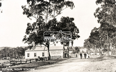 Eltham District Historical Society Inc
Negative - Photograph, Eltham, Main Road near station, c.1910
View looking north along Main Road, Eltham from near present day Dudley Street. On the immediate left is the railway station. The large weatherboard building on the bend (opposite present-day Arthur Street) with signs for General Store, Refreshments and Summer Drinks painted on the side is Luther and Ada Haley’s General Store and Bakery, built 1902. This was the first building in what is now Eltham’s present shopping town centre. Haley previously ran the General Store and Bakery on the corner of Main Road and York Street until his lease expired and the premises were bought by Mrs Sarah Burgoyne in 1902. The store later was known as Staff's Store. Followed by the saleyards, entrance to station, slaughter yard and William J Capewell’s butcher shop. Contained within the saleyards facing the street, a small shelter with the name H.H. Clark upon it. Horace Harold Clark was the son of Eltham State School’s first Head Teacher, David George Clark. As well as being a farmer, he was an Estate Agent and conducted auction sales, presumably from this shelter. On the eastern (right) side of Main Street is Haley’s Paddock, which was used on occasions for community picnics. Capable of holding 10,000 people, with ample shade and hilly surroundings it was an ideal place for any community gathering such as the State Schools’ Picnic in 1904. A worker from the bakery store is standing in the gateway at the rear of the store observing the photographer. People in the ‘Sunday Best’ are milling in front of the bakery or strolling down the centre of Main Road. The picture was most likely taken on a Sunday. With the opening of the railway to Eltham in 1902, Melbourne residents would regularly enjoy a Sunday excursion journey on the train to Eltham for a day’s outing to the countryside or beyond to Hurstbridge from 1912 when the railway was extended. Picture dated as c.1910 based on similar picture published in the Weekly Times, Feb. 1912. Cross Ref: 609 (looking south), 612, 611 (later stage), 613.Negative black and white film 120 6x9 format 2 stripsAgfa APX 100baker, butcher, eltham, eltham railway station, eltham sale yards, eltham slaughter yard, eltham town centre, general store, haley's paddock, hot water, luther haley, luther haley general store, m.m. clark, main road, railway station, shire of eltham pioneers photograph collection, shops, sign, staffs general store, summer drinks, w.j. capewell -
 Melton City Libraries
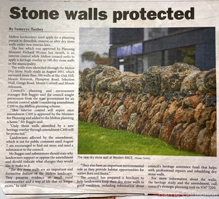
Newspaper, Stone Walls protected, 2015
Dry stone construction as a technique is used for much more than paddock walls. Across the volcanic plains of western Victoriaare marvelous sheep dips, stock loading ramps, huts, dams, retaining walls, and the rich and largely undiscovered heritage of indigenous dry stone structures. Dry stone walls indicate many aspects of our rural environment; the geological beginnings of the way the landscape was created, the patterns of early settlement by pastoralists and squatters, the types of stock that grazed the land and the methods of cattle and sheep management, of the efforts to thwart the spread of rabbits .... "For the casual but interested observer dry stone walls are good to look at, to photograph, to get up alongside and see the way they are constructed, to appreciate the varying shapes and sizes of stones and learn of the techniques of keeping often quite rounded stones in place. Apart from walls and other dry stone structures on grazing land we can also see dry stone techniques used in other places and in other phases of our history. Indigenous Australians have built, and continue to build, structures for shelter or hunting or trapping eels and fish in rivers and estuaries around the country. At spots around our coast line there is evidence of simple stone structures built by early maritime explorers. Prospectors in early mining encampments used dry stone construction to build retaining walls or the low walls of rudimentary shelters. If the future of dry stone walls in the Australian landscape is to be assured. wall owners and local governments have to accept and embrace their custodial role in assuring the preservation and celebration of walls. This is not an easy task, but, along with putting the necessary statutory mechanisms to ensure their retention, it is a task that must be pursued. The Dry Stone Walls Association of Australia has as its primary goal the increase in awareness of wall owners and local governments of the importance of dry stone walls. It also seeks to increase the level of training of skilled and semi skilled wallers, and the gaining of rudimentary skills by farmers so that they can maintain their own walls". Melton Star Weekly article about the Stone Wallslandscapes of significance -
 Ringwood and District Historical Society
Map - Public Land Sale by Thomas Ham, 2000 Acres for Sale - Crown Sections 20, 23, 24 - Ringwood, Victoria - 1855
Two 1850s surveyor's maps on cardboard backing showing area from Melbourne extending East beyond Bulleen and Nunawading. Detailed description of lots for sale and navigational directions to the property from Richmond by Thomas Ham, Victorian public servant, map maker, publisher, lithographer and original Ringwood land owner. Inset map enlarging area between Yarra River and Dandenong Creek, with southern boundary of allotments later forming part of Oban Road, North Ringwood.TRANSCRIPT: "This really valuable Property is now offered to the public for sale, in lots to suit purchasers at the Iow rate of £1 per Acre for 80 acres and upwards, and £1.10s per Acre for any smaller portion. Terms of payment Half Cash, Balance in 6 and 12 months, bearing 8 per cent interest. The Estate is well wooded with Gum, Cherry Tree and Stringy Bark, with Wattle in the valleys of the several creeks. Every lot is Staked and Trenched at the corners marked on the Plan thus - The Surveyor has carefully sub-divided the Property, in order to give every Farm a Creek for Water, Valley for Cultivation, and Hills for House and Grass Paddock. The ROADS have been very carefully laid out so as to give a firm, well drained, and nearly level road to each Homestead. Intending purchasers can readily find the property by the following directions, viz: Start from Richmond Bridge, at Hawthorne, then take the left-hand road to KEW. When at the "Woodman Inn", take the Cotham Road to the right, bearing due east, keep this Road, passing Trainor's "White Horse" Inn, and before you leave the fences, you will see calico bills (see margin) nailed to the Trees on the bush track leading to the Upper Yarra country, follow the Bills till you come to the SOUTH boundary line of the Property, which bears East and West (see Plan) where you will see Bills nailed up "THIS PROPERTY FOR SALE, etc." The Bills from Town lead direct to where Mr. Jull is erecting his Store, and arrangements have been made with him to show the lots to intending purchasers free of charge. At the respective corners of the lots the Bills are nailed up double, with numbers to denote the lot, and that the corner stake is adjacent. Any parties wishing to proceed to the property by way of BULLEEN will find Bills nailed on the Trees, commencing at the NEW INN, at "Wilson's Slip Rail." Keep this Track till you come to the Log Bridge, over the Deep Creek at Bloxhome's Paddock; go through the land now being cleared; keep the track over the hill till you come to an Iron House, you will then be on the property, which Iies to the North and East as per Plan. Follow the Bills till you come to Mr. Jull's Store, etc. etc. Further particulars can be had from the Agent for the Property. THOMAS HAM. " -
 Southern Sherbrooke Historical Society Inc.
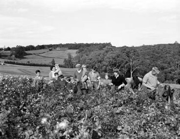
Photograph - Spykers family at Avonsleigh c.1960
Black and white photo showing a large family group in a flower field. In the background there are low hills with cleared paddocks and forested areas. According to the National Archives of Australia: 'Land was life for nurseryman Theo Spykers and his ancestors who had tilled the soil for generations; good land to own and to pass on to sons and their sons. At 42 Theo had one and a half acres near Rotterdam for a prosperous nursery, but he could only rent it and his family was growing. So, in 1948, Theo left his wife and six children at their home and set off by himself for Australia. Within a year he had paid a deposit on a broken-down property of 35 acres in the Dandenong ranges. His family joined him and they started to rehabilitate their new property. Mr and Mrs Spykers and twelve of their thirteen children pick chrysanthemums for sale in Melbourne, a city of 1,750,000. The children are; Theo, 20; Gerald, 15; Niko, 8; Frank, 5; Adolf, 22; Corrie, 11; Ria, 18; Terisa, 4; Anthony, 7; Tommy, 2; Elly, 10; Bill, 16.' Mr & Mrs Spykers are each holding one of the smaller children. This farm was on the corner of Birds Rd and Avon Rd, Avonsleigh. On the NAA records, Theodorus Gerardus Spykers arrived in Melbourne on the Muiderkerk on 27th February 1948. Black and white photo showing 15 year old Gerald Spykers carrying bundles of chrysanthemums tied ready for market. He is at the family farm on the corner of Birds Rd and Avon Rd, Avonsleigh. -
 University of Melbourne, Burnley Campus Archives
Album - Colour 35mm slides and colour prints, Geoff Olive, Geoff Olive Collection, 1979-2000
Collection of photographs and slides taken by Geoff Olive (Horticultural Instructor). (1) "Burnley 1979 Flash flood outside engineering." (2, 3) Administration Building, different years. (4) "Trish Mooney Gardener 1998." (5) 15-7-00 Ellis Stones Garden Friends Working Bee Tim and Chris." (6, 7) "Photos taken by John Dwyer (N.C.H.H.) following a tour of the native garden area given by Chris. 3.11.99." (8) Garden Week 1989? Phil Tulk Andrew Smith." Slides (9) "Rose Bed." (10) "Choisya ternata." entrance to what became the Rose Garden from Oak Lawn. (11) Aug 1981 view of Luffmann Ponds from Administration Building. (12) Nov 1982 "Herbaceous Border & Annual Display BHC" view of Bergenia Walk towards Administration Building. (13) May 1986 view of Administration Building from Luffmann Ponds. (14) August 1990 "Paula Cave/Andrew Smith" rejuvenating Luffmann Ponds. (15) April "Andrew Smith" mulching around Cork Oak when Staff Car Park removed from Bull Paddock. (16) April 1990 compacted lawn after last Garden Week at Burnley. (17) August 1990 Garden view. (18) August 1990 view of Luffmann Ponds from Administration Building roof. (19, 20) August 1990 View of Kath Deery Native Garden from Administration Building roof. Some handwritten notes on scraps of paper.geoff olive, horticultural instructor, burnley, floods, administration building, trish mooney, gardener, 1998, ellis stones garden, working bee, john dwyer, phil tulk, andrew smith, kath deery native garden, rose garden, herbaceous border, paula cave, luffmann ponds, bull paddock, garden week, lily ponds