Showing 4020 items
matching surveying
-
 Department of Energy, Environment and Climate Action
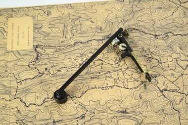
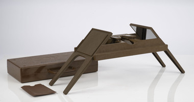
Planimeter (fixed arm)
... Surveying ...The heavy weight is pinned onto the map and the tracing arm is used to follow the boundary to be measured Reading the number of revolutions from the two the scale wheels the area in square inches could be measured. Knowing the scale of the mapsheet the figure was converted to areas or hectares Generally at least three measurements were taken to ensure accuracy and precisionPlanimeter used to measure areas from scale maps. Includes wooden box One revolution of the main wheel equaled 10 square inches. A smaller rotating scale on the side was used to subdivide the area.Benallaforests commission victoria (fcv), forest measurement, surveying -
 Department of Energy, Environment and Climate Action
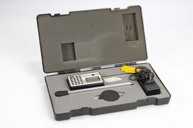
Planimeter (Digital)
... Surveying ...The heavy weight is pinned onto the map and the tracing arm is used to follow the boundary to be measured. Reading from the digital scale the area in square centimetres could be measured. Knowing the scale of the mapsheet the figure was converted to areas or hectares Generally at least three measurements were taken to ensure accuracy and precisionPlanimeter used to measure areas from scale maps. Kent Planitron UP103forests commission victoria (fcv), forest measurement, surveying -
 Department of Energy, Environment and Climate Action
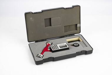
Planimeter (roller digital)
... Surveying ...The rollers move over the map as the tracing arm is used to follow the boundary to be measured. The wheels allow unlimited horizontal travel and vertical travel within the limits of the arm movement. They measure in the X and Y directions Reading from the digital scale the area in square centimetres could be measured. Knowing the scale of the mapsheet the figure was converted to areas or hectares Generally at least three measurements were taken to ensure accuracy and precisionPlanimeter used to measure areas from scale maps. Includes box but no charger Plancom KP90forests commission victoria (fcv), forest measurement, surveying -
 Department of Energy, Environment and Climate Action
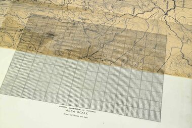
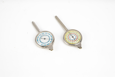
Area Scale - Dot Grid
... Surveying ...These transparent sheets were used to measure area on maps at various scales. They were used if a planimeter wasn't available The sheet was overlayed on the map and the shape transferred with a soft China graph or erasable lead pencil The number of "dots" within the shape were counted and converted to an area Each major 1 inch square block contained 100 dots (10 x 10)Transparent dot grid sheet Forests Commission of Victoria Area Scale Scale 30 chains to the inchforests commission victoria (fcv), forest measurement, surveying -
 Department of Energy, Environment and Climate Action
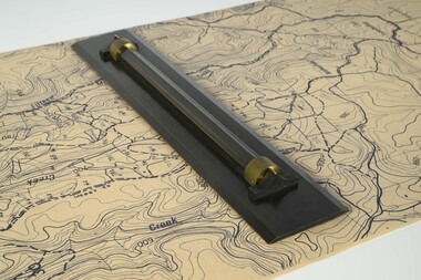
Parallel ruler
... Surveying ...Used to draw parallel lines on mapsHeavy metal ruler on brass rollers with a wooden boxforests commission victoria (fcv), surveying, mapping -
 Department of Energy, Environment and Climate Action
Dumpy level
... Surveying ...Engineers level used to lay out construction sites, roads and contoursMetal dumpy with box level SCAforests commission victoria (fcv), surveying, mapping -
 Department of Energy, Environment and Climate Action
map measuring wheels
... Surveying ...The map wheel is a simple, fast and accurate way to measure distances on maps, whether in straight lines or along curves. Hold the device from the tip and trace with the small wheel at the bottom along the line to be measured Measures distances in miles, kilometres or nautical miles depending on the scale on the side.Two metal map measuring wheel sMap scales on each side of wheelforests commission victoria (fcv), surveying, mapping -
 Department of Energy, Environment and Climate Action
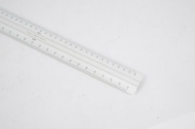
Mapping scale ruler
... Surveying ...Used to measure distance on scale mapsScale rulerW&G forests commission victoria (fcv), surveying, mapping -
 Department of Energy, Environment and Climate Action
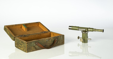
Foldable Stereoscope
... Surveying ...This stereoscope was used to view a pair of separate and overlapping aerial photos as a single three-dimensional image. This smaller foldable unit could be easily used in the field but larger, mirror stereoscope was used in offices. The aerial images were used to map forest types, timber stands, new roads and tracks, firebreaks, boundaries of timber harvesting, plantations, bushfires, insect and disease attack and so on In 1928, the Forests Commission undertook its first major aerial photography project over 15,000 acres of forest which is said to be the first of its kind in Australia. During the Second World War, large areas of Victoria were photographed by RAAF and used to produce orthophoto maps. By 1945 aerial photography of 13,000 square miles (3.4 M ha) was completed, including much of the inaccessible eastern forests. The Forests Commission started developing its own small format photography in the early 1970s. Simple, cheap and rapid methods of obtaining photographs using 70mm and 35mm cameras were developedFoldable plastic stereoscope in box Benallaforests commission victoria (fcv), surveying, forest measurement -
 Department of Energy, Environment and Climate Action
Stereoscope
... Surveying ...This stereoscope was used to view a pair of separate and overlapping aerial photos as a single three-dimensional image. Smaller units and could be easily used in the field but this larger, mirror stereoscope was used in offices. The aerial images were used to map forest types, timber stands, new roads and tracks, firebreaks, boundaries of timber harvesting, plantations, bushfires, insect and disease attack and so on In 1928, the Forests Commission undertook its first major aerial photography project over 15,000 acres of forest which is said to be the first of its kind in Australia. During the Second World War, large areas of Victoria were photographed by RAAF and used to produce orthophoto maps. By 1945 aerial photography of 13,000 square miles (3.4 M ha) was completed, including much of the inaccessible eastern forests. The Forests Commission started developing its own small format photography in the early 1970s. Simple, cheap and rapid methods of obtaining photographs using 70mm and 35mm cameras were developedFoldable metal stereoscope in wooden box with mirror covers Ex Dept of Defenceforests commission victoria (fcv), surveying, forest measurement -
 Department of Energy, Environment and Climate Action
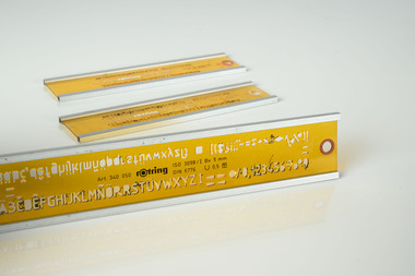
Rotring Lettering guides
... Surveying ...Different lettering guides were used depending on the scale of maps Cartographic guidance was provided by the FCV’s 1947 publication - “Handbook of Conventional Signs and Symbols for Use in Forest MappingPlastic lettering guides for use with ink Rotring pensRotring Scale and lettering sizes 5mmforests commission victoria (fcv), mapping, surveying -
 Department of Energy, Environment and Climate Action
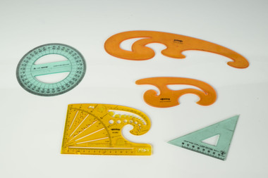
Rotring mapping shapes
... Surveying ...Used with Rotring ink pens of pencils to draw smooth shapes on mapsPlastic shapes used for mappingRotringforests commission victoria (fcv), mapping, surveying -
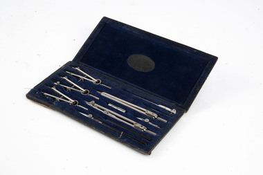 Department of Energy, Environment and Climate Action
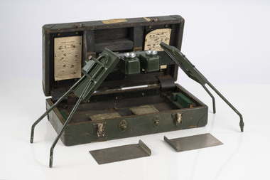
Equipment - 'Acorn' Mathematical Set
... Surveying ...This and other sets advertised on 30 January 1937 by MULLENS stationers in Melbourne (Trove) Given to or acquired by Forester James McKinty. Probably in late 1937. Used for map making and draftingStainless steel drawing tools in felt-lined wooden boxembossed on the fabric on the inside of the lid of the box: ACORN MATHEMATICAL SET ROBERTSON & MULLENS Ltd MELBOURNEforests commission victoria (fcv), mapping, surveying -
 Lakes Entrance Historical Society
Book, Marjorie Morgan, Crown Lands Pre-emptive Rights Agreement, 1987
... Surveying ...Fasimile reproduction of Victorian Government records giving valuation of Crown Lands under Pre emptive right originally printed in sixteen counties and four districts are included.settlers, surveying, land settlement -
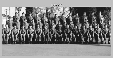 Bendigo Military Museum
Photograph - Cartographic Squadron, Army Survey Regiment, Fortuna, Bendigo, c1985
This is believed to be a photograph of Cartographic Squadron, one of the Army Survey Regiment’s squadrons at Fortuna, Bendigo. It was probably taken on Corps Day in July 1985 as its members appear in winter dress. Cartographic technician tasks undertaken by Cartographic Squadron at that time were scribing, compiling, retouching, masking, type setting, type stickup, terrain embossing, correcting and proving quality control. This is a photograph of Cartographic Squadron taken at the Army Survey Regiment, Fortuna, Bendigo. c1985. The black and white photograph was printed on photographic paper and is part of the Army Survey Regiment’s Collection. The photograph was scanned at 600 dpi. .1) - Photo, black & white, 1985, Cartographic Squadron, Army Survey Regiment. Back Row L to R: CPL Dave Cook, SPR John Keely, CPL Perry Burt, CPL Terry ‘TJ’ Wicker, CPL Roger Pearson, CPL Simon ‘Andy’ Capp, CPL Paul Richards, SPR Owen Jones, SPR Bjorn Sakariassen, CPL Graeme Priestley, SPR Roger Graf, SPR Robin Marshall, SGT Paul Hopes. Middle Row L to R: SPR Max Watson, CPL Doug Home, SGT Mick Flynn, SGT Alan Staley, CPL John Reid, SPR Denise (Muldoon) Marshall, CPL Mark Casey, SGT Greg Anderson, SPR Leah (Hoffman) Peppler, SPR Gayle Humphrey, CPL John ‘Stormy’ Tempest, SGT Paul Leskovec CSM, SGT Graeme Dowd, SPR Tracy (Parker) Ash. Front Row L to R: SGT John Zuringer, SSGT Adrian ‘Charlie’ Creedy, SSGT Dennis McCarthy, SSGT Ian ‘Rock’ Thistleton, SSGT Trevor Pearson, WO2 Russ Larsen, WO1 Doug Arman, MAJ Terry Edwards, WO1 Bill Griggs, WO1 Dick Manley, SSGT Tony Harder RE (UK Exchange), SSGT Doug Gay, SGT Tim Allanson, SGT Dennis Learmonth.No personnel are identified. royal australian survey corps, rasvy, army survey regiment, army svy regt, fortuna, carto, asr -
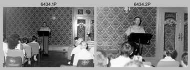 Bendigo Military Museum
Photograph - Army Survey Regiment Open Day - Briefings and Tours, Fortuna, Bendigo, 1990
These 27 photographs were taken at an Army Survey Regiment Open Day at Fortuna Villa, Bendigo on the 24th of February 1990. This occasion was one of several events held to commemorate the 75th anniversary of the formation of the Royal Australian Survey Corps. Although historical tours of Fortuna occurred on a regular basis, this was the first technical open day since 1972. The Royal Australian Survey Corps recognised that an Open Day was the best way for the local community in Bendigo to gain an insight into the unit’s important role as Defence’s map production agency, its technical equipment, and its economic importance to Bendigo. It also gave them an opportunity to tour through historic Fortuna Villa. This occasion is covered in more detail in page 143 of Valerie Lovejoy’s book 'Mapmakers of Fortuna – A history of the Army Survey Regiment’ ISBN: 0-646-42120-4. Refer to items 6435.35P and 6436.18P for more photos of the Open Day taken in the Map Production areas of Air Survey and Cartographic Squadron, and production areas of Lithographic Squadron. Photo prints of some of these photos were scanned and catalogued in items 6247.30P and 6291.6P.These 27 photographs were taken at an Army Survey Regiment Open Day held at Fortuna, Bendigo on the 24th of February 1990. The 35mm colour and black & white negatives photographs were scanned at 96 dpi and are part of the Army Survey Regiment’s Collection. .1) & .2) - Photo, black & white, 1990. Ballroom - Visitor briefings by CO LTCOL Rene van den Tol. .3) - Photo, colour, 1990. Ballroom - Visitor briefings by MAJ Ray Redman. .4) - Photo, colour, 1990. Ballroom - Visitor briefings by unidentified UK Exchange officer. .5) - Photo, black & white, 1990. Music Room - Visitor briefings by MAJ Bob Williams. .6) - Photo, black & white, 1990. Orderly Room - ADJT CAPT Peter Parkes. .7) - Photo, colour, 1990. Music Room - ADJT CAPT Peter Parkes with civilian visitors. .8) - Photo, colour, 1990. Music Room - Visitor briefings by CPL Le-Anne (Smallshaw) Shirley. .9) - Photo, colour, 1990. Entrance Foyer - Visitor briefings. .10) - Photo, colour, 1990. CO’s Office - Visitor briefings by CPL Raelene (Munting) Brodie. .11) - Photo, colour, 1990. Mr Pat Thwaites outlining utilisation of satellite imagery to civilian visitors. .12) - Photo, black & white, 1990. Mr Pat Thwaites outlining utilisation of satellite imagery to civilian visitors. .13) - Photo, colour, 1990. Staircase leading up to the top floor - Visitor briefings by CPL Ian Nelson. .14) - Photo, colour, 1990. Building 16 - Visitor briefings by RSM WO1 Neville Stone. .15) - Photo, colour, 1990. Civilian visitors enjoying views of the garden from Fortuna Villa’s rooftop. .16) - Photo, black & white, 1990. Visitor briefings at Fortuna’s rear steps. .17) - Photo, black & white, 1990. Outside Building 16 - Visitor briefings by WO1 Gary Warnest. .18) - Photo, colour, 1990. Outside Building 16 - Visitor briefings by WO2 Adrian ‘Charlie’ Creedy. .19) - Photo, colour, 1990. Outside Building 16 - L to R: SPR Sue (Foote) Bourne, LCPL Sandy Winn, WO2 Adrian ‘Charlie’ Creedy. .20) - Photo, colour, 1990. Outside Building 16 - SGT Greg Byers. .21) - Photo, colour, 1990. Visitors enjoying Devonshire Tea in the gardens next to the Tavern. .22) - Photo, colour, 1990. RSM WO1 Neville Stone and family enjoying Devonshire Tea in the gardens next to the Tavern. .23) - Photo, colour, 1990. Visitors relaxing in the garden next to Fortuna’s lake. .24) - Photo, black & white, 1990. CPL Trevor Poll and others serve up BBQ lunch next to the tennis courts. .25) to .27) - Photo, colour, 1990. Parking at a premium inside the Army Survey Regiment and Chum Street..1P to .27P – no annotationsroyal australian survey corps, rasvy, army survey regiment, army svy regt, fortuna, asr -
Ringwood and District Historical Society
Document - Land Title, John Quinlan et al, Land title (Ringwood) and correspondence between George Pratt of Nunawading and the Commissioner of Crown Lands 1869-1877, 1869
Land title and correspondence between George Pratt and the Commissioner of Crown Lands and Survey dated 19th(?) August 1869. Numbered 16678 (1M) plus 20 pages marked 42M-61M +Additional Keywords: Commissioner of Land and Survey / Longmare, Mr. / Quinlan, John -
University of Melbourne, Burnley Campus Archives
Plan, Wilsons Promontory8119-I and Glennie 8119-IV, 1971
State Aerial Survey Plan of Wilsons Promontory and Glennie. Dated 1971. Provisional Compilation of Sheets 8119-I and 8119-IV from Commonwealth Department of National Development Photography for the Department of Crown Lands and Survey Victoria. Students made excursions to Wilsons Promontory.wilsons promontory, glennie group, anser group, bass strait, aerial survey -
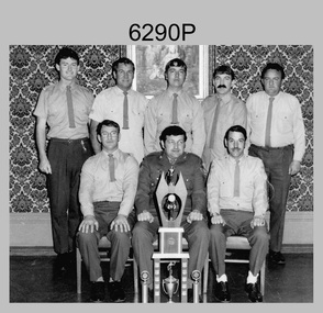 Bendigo Military Museum
Photograph - Local Competition Darts Team - Army Survey Regiment, Fortuna, c1982-1983
This photograph of Fortuna’s Darts Team was taken in the Ballroom at Fortuna Villa, Bendigo circa 1982-1983. Darts was a very popular sport played in the Army Survey Regiment’s messes for many years. Some of Fortuna’s highly skilled exponents of formed a team to participate in in the local competition held in several pubs around Bendigo. This victorious team appears with the championship trophy.This photograph of Fortuna’s Darts Team was taken in the Ballroom at Fortuna Villa, Bendigo circa 1982-1983. The photograph was printed on photographic paper and is part of the Army Survey Regiment’s Collection. The photograph was scanned at 300 dpi. .1) - Photo, black & white, c1982-1983. Back Row L to R: Steve Drummond, Tom Pattison, Dale Hudson, Steve Egan, Warren ‘Waldo’ Shirley. Front Row L to R: Unidentified (x2), Kevin ‘Spook’ Kennedy.No personnel are identified. “Unit Darts Team Local Competition 1982-83” on backroyal australian survey corps, rasvy, army survey regiment, army svy regt, fortuna, asr -
 Bendigo Military Museum
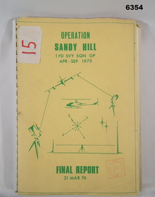
Administrative record - Operation Report - Operation Sandy Hill 1Fd Svy Sqn Apr - Sep 1975, 1 Fd Svy Sqn, 1976
Comprehensive Operation Report on Operation Sandy Hill conducted by 1Fd Svy Sqn Apr-Sep 1975 Part 1 Forward, Part 2 Planning and Mounting, Part 3 Final Report OC 1 Fd Svy Sqn, Part 4 Report Abn/EDM Gp, Part 5 Report Recon, Stn Marking and Traversing Gp, Part 6 Admin Report, Part 7 Report OC 171 Op Spt Sqn, Part 8 Computations and Results, Part 9 Observations and Recommendations.A4 size report held together with a plastic spiral binding, Light Cardboard cover includes many foldout Annexes"15" on front cover. Rubber stamp "Army Survey Regiment Map Library"royal australian survey corps, rasvy, fortuna, army survey regiment, army svy regt, asr -
 Greensborough Historical Society
Plan, Plan of Manatunga Circuit Greensborough subdivision, 1970_
Plan of Manatunga Circuit subdivision. Prepared by O'Connor and Beveridge (land surveyors) for Development Underwriting (developers). Plan of subdivision. Part of Crown Portion 3. Parish of Nillumbik, County of Evelyn.An original example of a subdivision plan in the expanding suburb of Greensborough. The 1960s and 1970s saw this area develop from a rural farming area to a suburb.Plan of subdivision. Printed on buff paper, hand coloured. Mounted on cardboard. Includes 2 small cards attached.Various handwritten comments. Small cards from Survey Branch, Office of Titles.greensborough, manatunga circuit, diamond creek road, plenty river drive -
Port Melbourne Historical & Preservation Society
Plan - Proposed land sub-division, west of railway, Sandridge, 19 Nov 1866
1866 plan of proposed sub-division of land at Sandridge, west of railway. Includes manure depot.J. Noone (Photolithographer, Dept. of Lands and Survey) J. Hardy (Assistant Surveyor)town planning, town planning - proposals shelved, j noone, j hardy -
 Bendigo Historical Society Inc.
Map - JACK FLYNN COLLECTION: TARNAGULLA SHEET 4, 25/11/1926
Map: Parish of Tarnagulla Sheet 4, Counties of Gladstone and Bendigo. Parish plan.Photo-Lithographed at the Department of lands and Survey, Melbourne by W. J. Butson. 25.11.26map, gladstone, parish plan, tarnagulla sheet 4 -
 Bendigo Historical Society Inc.
Map - JACK FLYNN COLLECTION: WELLSFORD, 2/11/1914
Map: Parish of Wellsford, County of Bendigo. Parish plan.Photo-Lithographed at the Department of Lands and Survey Melbourne By H.J. Butson. 2-.11.14map, bendigo, parish plan, wellsford -
 Bendigo Historical Society Inc.
Map - JACK FLYNN COLLECTION: HUNTLY, 12.03.1932
Map: Township of Huntly, Parish of Huntly , County of Bendigo. Parish plan. Western and South Riding Division on Main St. (Main Northern Highway) - written in ink below name of map.BY Authority H.J. Green. Photo-Lithographed at the Dept., of Lands and Survey, Melbourne. 12.3.32map, bendigo, township, huntly -
 Bacchus Marsh & District Historical Society
Map, Mooradoranook Parish Map, County of Grant
A single page paper map showing the map for the Parish of Mooradanook in the County of Grant. Cadastral map showing land ownership. The map is pasted into a bound volume containing 76 maps or plans in total. High resolution digital image stored on BMDHS computer network. Photo lithographed at the Department of Lands and Survey Melbourne by T. F. McGauran, 27.11.06mooradoranook parish maps, mooradoranook parish plan, bacchus marsh region parish plans -
 Bendigo Military Museum
Photograph - Army Survey Regiment - Regimental Training Military Skills Revision, c1984
This is a set of 25 photographs of the Army Survey Regiment personnel undertaking military skills revision, at the Army Survey Regiment, Fortuna, Bendigo, c1984. It is evident in the photos that they participated in lessons on the handling of the M30 Grenade and SLR Rifle, and lessons in first aid.This is a set of 25 photographs of the Army Survey Regiment undertaking military skills revision, part of Regimental Training at Fortuna Villa c1984. Colour photos are printed on photographic paper and scanned at 300 dpi. The photos are also stored on 35mm negative film. They are part of the Army Survey Regiment’s Collection. .1) & .2) - Photo, colour, c1984. Pre-training briefings on the parade ground. .3) - Photo, colour, c1984. Rifle revision training. L to R: unidentified personnel, WO2 Ralph Chant – instructor, SGT John Zuringer – instructor. .4) & .5) - Photo, colour, c1984. Rifle revision training. L to R: unidentified personnel, WO2 Ralph Chant – instructor. .6) - Photo, colour, c1984. Rifle revision training. L to R: WO2 Tony Clark – instructor, unidentified, SPR Sherri (Dally) Burke, CPL Robin Marshall, CPL Roger Pearson, SPR Bob Hopper, unidentified, CPL Dan Cirsky. .7) - Photo, colour, c1984. Rifle revision training. WO2 Tony Clark – instructor. .8) to .14) - Photo, colour, c1984. Hand grenade training. Unidentified soldier throwing grenade. .15) - Photo, colour, c1984. Hand grenade training. L to R: unidentified (x2) SPR Jann (Caithness) Lambdon-Young throwing grenade, WO2 Ian ‘Rock’ Thistleton. .16) - Photo, colour, c1984. Hand grenade training. L to R: unidentified soldier throwing grenade, WO2 Ian ‘Rock’ Thistleton. .17) - Photo, colour, c1984. Hand grenade training. L to R: unidentified, unidentified soldier throwing grenade. .18) - Photo, colour, c1984. Navigation revision L to R: CPL Gary Tremain, SPR Jim Humphrey. .19) & .20) - Photo, colour, c1984. Navigation revision. Unidentified personnel. .21) - Photo, colour, c1984. Navigation revision. SPR Tracy (Parker) Ash. .22) - Photo, colour, c1984. Navigation revision. Unidentified (x2), CPL Gary Tremain. .23) - Photo, colour, c1984. Navigation revision. L to R: CPL Lorraine (Daly) Talbot-Smith, SPR Jim Humphrey, unidentified (x4), SGT Gavin Neilson. .24) - Photo, colour, c1984. Navigation revision. L to R: CPL Lea-anne (Smallshaw) Shirley, CPL Lorraine (Daly) Talbot-Smith, unidentified, CPL Gary Tremain, unidentified. .25) - Photo, colour, c1984. First Aid revision. L to R: SGT Bruce Wetzig – instructor, CPL Ken Peters, unidentified..1P to .25P No personnel are identifiedroyal australian survey corps, rasvy, army survey regiment, army svy regt, fortuna -
 Bendigo Military Museum
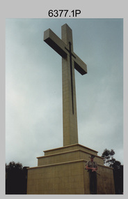
Photograph - Army Survey Regiment Mount Macedon Memorial Cross Ceremony, 1995
This set of six colour photographs of a Catafalque Party from the Army Survey Regiment was taken at the Mount Macedon Memorial Cross on the 19th of November 1995. The ceremony was held to commemorate the 60th anniversary and the refurbishment of the site. The refurbishment entailed the complete replacement of the cross and its surrounds. The cross is also known as the Cameron Memorial Cross and was built in 1935 as a memorial for those who lost their lives in the First World War. The Guest Speaker was Mr Bruce Ruxton AM MBE OBE, who at the time was the president of the Victorian RSL. He served in the 2/1st Australian Topographical Survey Company in WW2 before reallocation to the 2/25th Australian Infantry Battalion. He was the president of the Victorian RSL from 1979 to 2002 and was a staunch vocal advocate for the health and welfare of war veterans and their families. Refer to the Wikepedia web site for more detail on the history of the Mount Macedon Memorial Cross and Mr Bruce Ruxton AM MBE OBE.This set of six colour photographs of a Catafalque Party from the Army Survey Regiment was taken at the Mount Macedon Memorial Cross on the 19th of November 1995. The photographs were printed on photographic paper and are part of the Army Survey Regiment’s Collection. The photographs were scanned at 300 dpi. .1) - Photo, colour, 1995. Mount Macedon Memorial Cross Ceremony, SPR James Commons in foreground. .2) - Photo, colour, 1995. Mount Macedon Memorial Cross Ceremony, Guest Speaker - Mr Bruce Ruxton AM MBE OBE. .3) - Photo, colour, 1995. Mount Macedon Memorial Cross Ceremony, SPR Katie Royce, unidentified soldier in background. .4) - Photo, colour, 1995. Mount Macedon Memorial Cross Ceremony, James Commons. .5) - Photo, colour, 1995. Mount Macedon Memorial Cross Ceremony, L to R: SSGT Peter Coles, SPR James Commons. .6) - Photo, colour, 1995. Mount Macedon Memorial Cross Ceremony, SPR James Commons. Each photo is annotated ‘Mt Macedon Memorial Cross Ceremony 19 Nov 95. Mr Bruce Ruxton AM MBE, OBE, SSGT Peter Coles, SPR Katie Royce and SPR James Commons are identified on the photos. royal australian survey corps, rasvy, army survey regiment, army svy regt, fortuna, asr -
 Ringwood and District Historical Society
Map, Allotments - Township of Ringwood - Parish of Ringwood - County of Mornington - 1886, 1886
[Page 3, Horse Shoes to High Heels - Richard Carter] ... "(In the year 1882) the railway was extended from Hawthorn through Ringwood to Lilydale and later to Ferntree Gully." Linen-backed map of Ringwood area lithographed at the Department of Lands and Survey, Melbourne, 5th November, 1886.old lilydale road, new lilydale road, victoria brick and tile co., ringwood brick co., federal brick co. -
 Phillip Island and District Historical Society Inc.
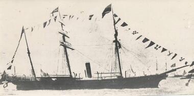
Photograph, 1865
One of a collection of over 400 photographs in an album commenced in 1960 and presented to the Phillip Island & Westernport Historical Society by the Shire of Phillip IslandPhotograph of the ship "Victoria" which surveyed Western Post in 1865. The first Victorian Man-o-War.local history, photography, photographs, maritime technology, boats, steam sailing ship "victoria", black & white photograph, ships, man-o-war, western port, survey, john jenner, bryant west