Showing 762 items
matching aerial views
-
 Glenelg Shire Council Cultural Collection
Film - Colour Film - aerial view of Cape Grant Quarry, 1956-1958
... Colour Film - aerial view of Cape Grant Quarry... Cliff Street Portland great-ocean-road Colour Film - aerial view ...Port of Portland AuthorityFront: (Colour) Oats/ Handling (blue pen on white tape, top of reel) Harbour/ Construction/ NOT EDITED (Colour) (Blue pen on white tape, top of reel)port of portland archives, film, cape grant quarry -
 Port Melbourne Historical & Preservation Society
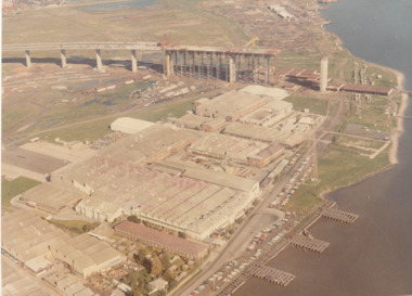
Photograph - Aerial view of West Gate Bridge under construction, 1960 - 1979
... Aerial view of West Gate Bridge under construction... Aerial view of West Gate Bridge under construction ...Colour aerial (faded) photograph of West Gate Bridge under construction with two land spans incomplete. "Rotten Row" (disused old piers) in the foreground. Aircraft factory and other industry in foreground."Master Copy . Not to be removed from Marketing department " lightly stamped on photo. and on reartransport, engineering, engineering - bridges, fishermans bend, industry, west gate bridge, rotten row, williamstown, yarra river -
 Port Melbourne Historical & Preservation Society
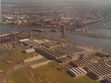
Photograph - Aerial view of West Gate Bridge under construction, 1960 - 1979
... Aerial view of West Gate Bridge under construction... Aerial view of West Gate Bridge under construction ...Colour aerial photograph of West Gate Bridge under construction. Fishermans Bend factories in foreground. Ship in the river and view to Williamstown"Master copy. Not to be removed from marketing Department" stamped on top right corner and on backtransport, engineering, engineering - bridges, fishermans bend, industry, west gate bridge, rotten row, williamstown, yarra river -
 Port Melbourne Historical & Preservation Society
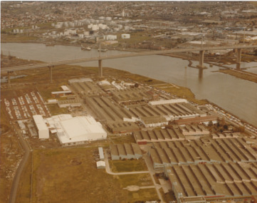
Photograph - Aerial view of West Gate Bridge under construction, 1970 - 1979
... Aerial view of West Gate Bridge under construction... Aerial view of West Gate Bridge under construction ...Colour aerial photograph of West Gate Bridge completed. Aircraft factory and other industry in foreground. Williamstown and fuel storage tanks in background (Coode Island)"Gov't A/C Factories Photographic Section Neg No N2841/3" stamped on backtransport, engineering, engineering - bridges, fishermans bend, industry, west gate bridge, rotten row, williamstown, yarra river -
 City of Kingston
Photograph - Black and white, c. 1970
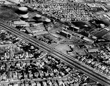
The Highett Gas Works were a landmark along the Nepean Highway for many years. With the cessation of the gasification of coal and the introduction of natural gas to Victoria, the gas holders were demolished and the Sir William Fry Reserve was developed on the southern end of the site. The Gas and Fuel redeveloped the northern end of the site with modern offices and laboratories for the organisation's scientific services. At this time, the chimney and retort house were retained.The Highett Gasworks had its beginning in 1939 operated by the Central Brighton and Moorabbin Gas Co Ltd. The company had expanded its gas production facilities to Highett where it had purchased 45 acres of land adjacent to the Melbourne-Frankston railway line. The first gasholder was erected on the Highett site in 1927 and connected with high pressure mains to the Brighton Gas Works. In 1939 the building program including gasometers, the vertical retort house and coal store was completed and gas making commenced. Its area of supply covered approximately 70 square miles and included the municipalities of Brighton, Sandringham, Moorabbin, Mordialloc, Chelsea and part of Dandenong. The Gas and Fuel Corporation eventually took over operations and with the disaggregation and privatisation of the organisation, the site was eventually closed c. 2002.Black and white aerial photograph featuring the Highett Gas Works with gasholders and retort house. In the top right-hand corner, a former Highett Primary School on Graham Road can be viewed. Photograph includes Bay Road, Royal Avenue, Princess Avenue and Jackson Road (Highett) and Alfred, Turner and Sandford Streets (Moorabbin).Handwritten in black ink: [indecipherable] in a circle Handwritten in red ink: 70% Four velcro display adhesivesgasification of coal, gas and fuel corporation of victoria, gasholders, highett, moorabbin, utilities -
City of Kingston
Photograph - Colour, 6 March 1993
Edithvale is a suburb in the City of Kingston. It is located between Aspendale and Chelsea on the Port Phillip Bay and built within remnant areas of the Carrum Carrum swamp. The foreshore precinct comprises a wide sandy beach, with low sand dunes and numerous historic boat sheds. The suburb consists of older style dwellings and former holiday houses, combined with mid-century housing and newer homes. The large blocks are increasingly subdivided and the existing dwellings demolished to accommodate units and townhouses, thus changing the landscape of the area and reducing the tree canopy.The beachside suburb of Edithvale was previously part of the extensive Carrum Carrum Swamp. The area was once a source of fish and eels for the Mayone-Bulluk clan of the Bunurong people. Over time the area was drained and predominantly devoted to dairy farming and holiday houses. The farms were gradually sold and subdivided with a large number of homes built after World War II and in the 1960s. Edithvale is mainly residential with a shopping strip along Nepean Highway but little significant industry was ever established in the area apart from a plaster works and confectionary factory, both now closed.Laminated aerial colour photograph of Edithvale as viewed from Alexandra Avenue in the north to Ella Grove Chelsea/Edithvale in the south. regents Park Aspendale can be seen in the top left. The area is built-up with residential housing and facilities including Edithvale Primary School, numerous churches and the Edithvale Railway station. Large sections depict the remnant Carrum Carrum swamp. Edithvale Common and the former "Duck Inn" (Melbourne Water/Friends of Edithvale Seaford Wetlands) can be seen. Edithvale Recreational reserve, the valodrome and Edithvale Public Golf Course are prominent. The image shows vacant land in the area now known as Aspendale Gardens and the newer residential section of Chelsea Heights is not developed. A bike path has been established to cover the secondary drain. The Golf Links Court residential development located off Hughes Avenue is a large vacant block.Black type on white adhesive label: 6-3-93 Black type on white adhesive label: 25/9211, 6/3/93, 11.20 am Black type on white adhesive label: 9211 Yellow circular adhesive sticker Black pencil: 9211 6-3-93 arrow pointing Nedthvale, carrum carrum swamp, aspendale, chelsea -
City of Kingston
Photograph - Colour, Circa 1993
Edithvale is a suburb in the City of Kingston. It is located between Aspendale and Chelsea on the Port Phillip Bay and built within remnant areas of the Carrum Carrum swamp. The foreshore precinct comprises a wide sandy beach, with low sand dunes and numerous historic boat sheds. The suburb consists of older style dwellings and former holiday houses, combined with mid-century housing and newer homes. The large blocks are increasingly subdivided and the existing dwellings demolished to accommodate units and townhouses, thus changing the landscape of the area and reducing the tree canopy.The beachside suburb of Edithvale was previously part of the extensive Carrum Carrum Swamp. The area was once a source of fish and eels for the Mayone-Bulluk clan of the Bunurong people. Over time the area was drained and predominantly devoted to dairy farming and holiday houses. The farms were gradually sold and subdivided with a large number of homes built after World War II and in the 1960s. Edithvale is mainly residential with a shopping strip along Nepean Highway but little significant industry was ever established in the area apart from a plaster works and confectionary factory, both now closed.Aerial colour photograph of Edithvale as viewed from Alexandra Avenue in the north to Ella Grove Chelsea/Edithvale in the south. The area is built-up with residential housing and facilities including Edithvale Primary School, numerous churches and the Edithvale Railway station. Large sections depict the remnant Carrum Carrum swamp. Edithvale Common and the former "Duck Inn" (Melbourne Water/Friends of Edithvale Seaford Wetlands) can be seen. Edithvale Recreational reserve, the valodrome and Edithvale Public Golf Course are prominent. The image shows vacant land in the area now known as Aspendale Gardens and the newer residential section of Chelsea Heights is not developed. A bike path has been established to cover the secondary drain. The Golf Links Court residential development located off Hughes Avenue is a large vacant block.Yellow circular adhesive sticker on plastic Black ink (marker): * (asterisk) Black type on white adhesive sticker: P000108edithvale, aspendale, chelsea, carrum carrum swamp -
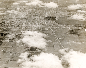 Ballaarat Mechanics' Institute (BMI Ballarat)
Print - Photograph by Herb Richmond. ca 1971, Ballarat aerial view
... Ballarat aerial view... view Old matte print Ballarat History Ballarat Ballaraat Aerial ...Ballarat HistoryOld matte printballarat, ballaraat, aerial -
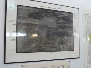 National Vietnam Veterans Museum (NVVM)
Photograph, Aerial photo of Nui Dat Base
Black & white aerial photo of "Nui Dat - vietnam (1966 - 1972)" oblique view looking north. Arrows point to buildings which are identified in the borders of the photo.nui dat base - buildings -
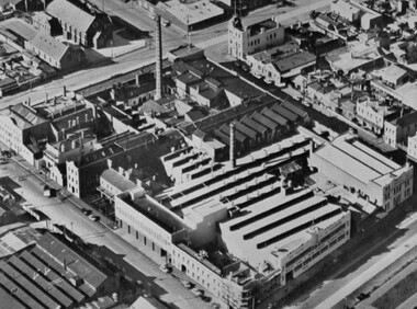 Port Melbourne Historical & Preservation Society
Photograph - Aerial view of Swallow and Ariell factory, Port Melbourne, c. 1950
... Aerial view of Swallow and Ariell factory, Port Melbourne... building visible on right hand side of photo Photograph Aerial view ...The Sandridge Marine Lodge was founded in 1858. Two locations; originally Stokes St and then in Liardet St from 1917. Both buildings are now converted to apartments. .03 - Aerial photo of Swallow and Ariell factory, with Stokes St Lodge building visible on right hand side of photobuilt environment - civic, built environment - domestic, societies clubs unions and other organisations, built environment - industrial, freemasons lodge, swallow & ariell ltd, sandridge marine lodge -
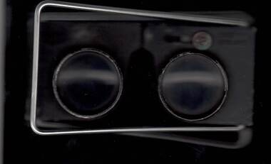
 Bendigo Military Museum
Instrument - Universal Stereoscope, 1940
... in many theatres of War for viewing and annotating aerial...The Universal Stereoscope was used to view overlapping... in many theatres of War for viewing and annotating aerial ...The Universal Stereoscope was used to view overlapping stereo aerial photography in three dimensions (3D). It consists of magnifying lenses, an optical train including glass prisms and mirrors that are protected by sliding metal covers all suspended on a pair of fold out adjustable legs. The stereoscope is coloured military olive drab green. This Universal Stereoscope was produced in Australia in 1940 for Military use. It was originally produced with a timber protecting carry box that is missing. It was used extensively by members of the Australian Survey Corps during WWII in many theatres of War for viewing and annotating aerial photography. Item 6205.6P, photograph 6205.1P shows the Universal Stereoscope in use by the Australian Survey Corps annotating aerial photography.The Universal Stereoscope was used to view overlapping stereo aerial photography in three dimensions (3D). It consists of magnifying lenses, an optical train including glass prisms and mirrors that are protected by sliding metal covers all suspended on a pair of fold out adjustable legs. The stereoscope is coloured military olive drab green."DC-1940 Serial No 550", "D V D", "Made in Australia" Plate on the underside reads " This stereoscope was donated to the Ex Fortuna Survey Association by the Eaglehawk Recycle Shop February 2015"royal australian survey corps, rasvy, fortuna, army survey regiment, army svy regt, asr -
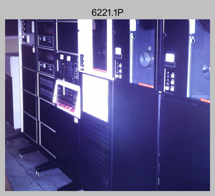 Bendigo Military Museum
Photograph - Aerotriangulation Production – Army Survey Regiment, Fortuna, Bendigo, Aerotriangulation Production – Army Survey Regiment, Fortuna, Bendigo, c1970s to 1980s
This collection of 14 photos was most likely taken in the 1970s and 1980s in Air Survey Squadron. The PDP 11/70 minicomputer shown in photo .1P was the operating system introduced in 1977 as the mainframe system for the control of the APC4, aerial triangulation block adjustments, SORA OP Analytical Orthophoto control, APR Analytical Terrain Profile Recorder computation, graphics, and general computing. Technicians used the Wild A9 Stereocomparator shown in photo .2P to accurately measure between pass, tie, and survey control points on aerial photographs. The Zeiss D2 Planimat Stereoplotter shown in photos .3P to .4P was used for analytical orthophoto control. It was introduced in 1972-1973 The Zeiss (Jena) Stecometer analytic stereocomparator for air photography shown in photos .5P to .11P and .14P was introduced at Air Survey Squadron in 1963. Aerotriangulation production was expedited using computers for analytical photogrammetric processes. The technician accurately measured between pass, tie, and survey control points on aerial photographs. Wild PUG4 point transfer devices shown in photos .12P to .13P were introduced in c1968 superseding the PUG2 devices. PUG4 devices were used by technicians to stereoscopically view the photography containing the survey control points and the mapping aerial photography. The Control points were transferred from the control photography to the mapping diapositives of aerial photography by drilling their locations into the photographic emulsion.This is a set of 14 photographs of Air Survey Squadron personnel operating aerotriangulation equipment at the Army Survey Regiment at Fortuna, Bendigo, c1970s to 1980s. Photographs .1P to .13P were on 35mm colour slide film and scanned at 96 dpi. Photograph.14P was printed on photographic paper and was scanned at 300 dpi. They are part of the Army Survey Regiment’s Collection. .1) - Photo, colour, c1979, PDP-11 minicomputer. .2) - Photo, colour, c1970s, Unidentified technician operating a Wild A9 Stereocomparator. .3) - Photo, colour, c1970s, Zeiss D2 Planimat Stereoplotter. .4) - Photo, colour, c1970s, Zeiss D2 Planimat Stereoplotter, unidentified technicians. .5) - Photo, colour, c1970s, Zeiss D2 Planimat Stereoplotter, SGT Christopher Wardley. .6) - Photo, colour, c1970s, Zeiss D2 Planimat Stereoplotter. .7) to.9) - Photo, colour, c1970, Zeiss (Jena) Stecometer, unidentified technicians. .10) to.11) - Photo, colour, c1988, SPR Toni Wright operating a Zeiss (Jena) Stecometer. .12) - Photo, colour, c1970s, Wild PUG4 point transfer device, SPR John Shepard. .13) - Photo, colour, c1970s, Wild PUG4 point transfer device, SPR David Edwards. .13) - Photo, colour, c1970s, Wild PUG4 point transfer device, SPR David Edwards. .14) - Photo, colour, c1980, Zeiss (Jena) Stecometer, SGT Bruce Hammond.Some of the equipment is annotated on the frame of the 35mm slides.royal australian survey corps, rasvy, army survey regiment, army svy regt, fortuna, asr, aerotrig, photogrammetry -
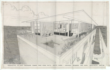 Robin Boyd Foundation
Drawing - Aerial Perspective, Domain Park, Sept 1960
Project: Domain Park from office of Grounds Romberg and Boyd. Perspective of Penthouse. The Domain Park flats (1959-62) were designed by Robin Boyd and were among the first high-rise blocks of ‘luxury’ flats constructed in post-war Melbourne. This exterior perspective highlights the unparalleled views available from the penthouse apartment.Aerial Perspective, Tracing Paperdomain park, robin boyd, ohm2022, ohm2022_14 -
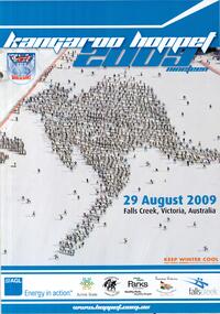 Falls Creek Historical Society
Poster - Kangaroo Hoppet 2009
The Kangaroo Hoppet is Australia’s premier long distance cross country ski race, and a member of the Worldloppet series of international cross country ski events. The first race at Falls Creek was held in 1979 under the name of “Australian Birkebeiner”. It was a 21km race with about 80 participants organised by the Birkebeiner Nordic Ski Club of Mount Beauty. The course started and finished at Falls Creek Alpine Resort and took participants out into the Bogong High Plains. After running the event for 10 years, it was decided they should become part of the Worldloppet series of marathon ski races. Representatives from the Birkebeiner Nordic Ski Club and the Australian Ski Federation attended the Worldloppet Annual Meeting in Finland in June 1990 to put the case for the acceptance of an Australian event into the Worldloppet series. Before being admitted, they had to demonstrate that the Birkebeiner Club could run a world class event, so three months later in August 1990 a 42km event named the Australian International Ski Marathon was held at Falls Creek together with a 21km Birkebeiner race and a 7km event called the Birkebeiner Lite. The event was approved by delegates from USA, Norway and Austria, in 1991 Australia became the 12th member of Worldloppet, with the condition that there had to be a name change. After some late night discussion allegedly involving red wine from North East Victoria the main event became the 42km Kangaroo Hoppet, with the minor events being the 21km Australian Birkebeiner, and 7km Joey Hoppet. In the winter of 1991, the first Kangaroo Hoppet was held. It was a great success and has been a regular fixture on the international ski calendar ever since. It features the main 42km event as well as a 21km event and a 7km event. The Hoppet brings the Australian snowfields to an international audience. In 2009 the Men's Winner was Ben Sim from Australia in a time of 0:58:39.4. The winner of the Women's event was Kate Calder of New Zealand in a time of 1:07:48.9. Due to the poor weather, and in view of skier safety and poor snow cover, a modified course was set. he Hoppet was reduced from 42 to 25 kms. This poster is significant because it documents an event which brings international attention to Falls Creek and the surrounding region.A poster with an aerial photo of a large number of skiers in the formation of the shape of a kangaroo. The colour of the border is blue, white and orange text is used. The Worldloppet logo is at the top left. The logos of AGL, Alpine Shire, Birkebeiner Nordic Ski Club, Parks Victoria, Tourism Victoria and Falls Creek are across the bottom of the poster. At the top: KANGAROO HOPPET 2009 NINETEEN At the foot of the kangaroo shape: 29 AUGUST 2009 FALLS CREEK, VICTORIA, AUSTRALIA In orange text: KEEP WINTER COOL FIGHT GLOBAL WARMING WWW.KEEPWINTER COOL.COM.AU At bottom in white text: www.hoppet.com.au kangaroo hoppet, worldloppet events, falls creek, mt. beauty -
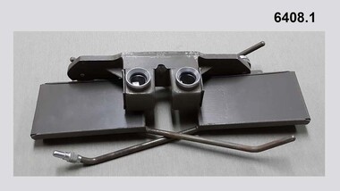
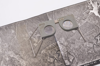 Forests Commission Retired Personnel Association (FCRPA)
Pocket Stereoscope
This pocket stereoscope was used to view a pair of separate and overlapping aerial photos as a single three-dimensional image. It was small and could be easily used in the field. Larger, mirror stereoscope were also available in some offices. The aerial images were used to map forest types, timber stands, new roads and tracks, firebreaks, boundaries of timber harvesting, plantations, bushfires, insect and disease attack and so on In 1928, the Forests Commission undertook its first major aerial photography project over 15,000 acres of forest which is said to be the first of its kind in Australia. During the Second World War, large areas of Victoria were photographed by RAAF and used to produce orthophoto maps. By 1945 aerial photography of 13,000 square miles (3.4 M ha) was completed, including much of the inaccessible eastern forests. The Forests Commission started developing its own small format photography in the early 1970s. Simple, cheap and rapid methods of obtaining photographs using 70mm and 35mm cameras were developed Small pocket stereoscope to interprete aerial photographs in the field Adjustable lenses on foldaway wire legsSokkisha Tokyoforest measurement -
 Queenscliffe Maritime Museum
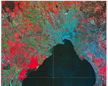
Print - Melbourne by Satellite by Woman's Weekly c1986, Aerial photo of Port Phillip c1986, c1986
... Port Phillip Aerial view of Port Phillip from 705km, 1986 ...Port PhillipAerial view of Port Phillip from 705km, 1986.Colour print insert from Woman's Weekly 1986, 'Melbourne by Satellite'.Reverse " Nil " -
Stawell Historical Society Inc
Photograph, Stawell Industrial Area Aerial View with the Woollen Mills, Stawell Timber Industry & Pleasant Creek Hospital
... Stawell Industrial Area Aerial View with the Woollen Mills... Aerial View with the Woollen Mills, Stawell Timber Industry ...Aerial Photograph Woollen Mills, Stawell Timber Industry, Pleasant Creek Hospital, Oval,.industry -
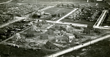 Port Melbourne Historical & Preservation Society
Photograph - Aerial view of houses during construction on Dunstan Estate, Port Melbourne, Department of Public Works, 1936
... Aerial view of houses during construction on Dunstan Estate... parked in streets Photograph Aerial view of houses during ...Twenty five (25) black and white or sepia photographs of the houses of the Dunstan Estate during their construction i.e. Griffin Crescent and Southward Avenue .04 - Aerial photographs (also shows Graham St School) Taken in 1936, some cars shown parked in streetsbuilt environment - domestic, domestic life, department of public works, dunstan estate, percy e everett, henry pye, albert dunstan -
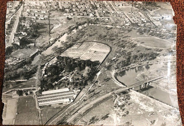 University of Melbourne, Burnley Campus Archives
Photograph - Black and white print, Airspy, Aerial View of Burnley Campus c. 1930, c. 1930
... Aerial View of Burnley Campus c. 1930...) and the Box Thorn Hedge (Lycium ferrocissimum). Aerial View of Burnley ...Taken before the Boulevard was built, and probably before the flood of 1934. Therefore probably 1929-1934. Information provided by TH Kneen and EB LittlejohnColour photograph of black and white photograph. Photograph of Burnley Campus and large area of surrounding suburbs of Hawthorn and Toorak. It shows the Carter Oval, later modified, the Plant Research Institute (built 1929) and the Box Thorn Hedge (Lycium ferrocissimum).burnley campus, suburbs, hawthorn, toorak, carter oval, plant research institute, boxthorn hedge, lycium ferrocissimum -
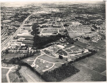 Ringwood and District Historical Society
Photograph, Aerial View of Ringwood, Victoria - circa 1970
... Aerial View of Ringwood, Victoria - circa 1970... Court, Highland Boulevard, Ailsa Court. Aerial View of Ringwood ...Black & white west-facing view over Oban Road along Mullum Mullum Road and Creek. Foreground showing early subdivision development of "Dunn's Orchard Estate" with formation of Frederic Drive (named after the orchardist - Frederic Dunn), Baron Court, Towerhill Drive, Tyson Court, Adele Court, Marilyn Crescent, Abbey Court, Highland Boulevard, Ailsa Court. -
 Kew Historical Society Inc
Photograph - Aerial View of East Kew, c.1930
... Aerial View of East Kew.... Photograph Aerial View of East Kew ...The Municipality of Kew was proclaimed in 1860. This eastern section of Kew was settled from the 1850s with all land sold in the vicinity by 1851. The original large estates were further subdivided in the second half of the 19th and in the first decades of the 20th centuries.Early aerial photograph of KewFramed aerial photograph of that part of Kew in which is located Genazzano FCJ, the Kew Reservoir, and the retail nurseries of Bennett’s and Rimington's.genazzano fcj, kew reservoir, rimington's nurseries, bennett's nursery, cotham road, mont victor road (kew) -
Lakes Entrance Regional Historical Society (operating as Lakes Entrance History Centre & Museum)
Photograph, 1940c
Also black and white postcard of same view number 03853.1 size 8.5 x 14 cmBlack and white aerial photograph of town looking west from Mechanics Street to Bullock Island with Kalimna escarpment and Rigby Fraser and Flanagan Islands in distance, Avenue of Honour Cypress trees on foreshore Lakes Entrance Victoriaaerial photograph, settlement, caravan parks, camping -
Lakes Entrance Regional Historical Society (operating as Lakes Entrance History Centre & Museum)
Photograph, 1880 c
Colour photograph print of early painting of view from Jemmys Point towards Metung showing paddle steamer and Aboriginals in bottom left hand corner Rigby Fraser and Flannagan Islands centre of painting, The Barrier on the left Nungurner Hills on right Gippsland LakesEntrance to The Gippsland Lakesaerial photograph, township, topography -
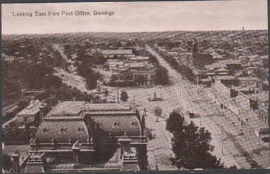 Bendigo Historical Society Inc.
Postcard - Sepia Postcard of old Bendigo
... aerial view towards east Bendigo... Office tower. aerial view towards east Bendigo Sepia postcard ...BHS CollectionSepia postcard of old Bendigo - detailed as "Looking East from Post Office, Bendigo"; taken from the Post Office tower. Rear is unstamped - therefore not posted. Personal message addressed to Dear Addie from Fred (!!) acknowledges a short holiday in Bendigo.bendigo looking east along pall mall taken from the post office tower., aerial view towards east bendigo -
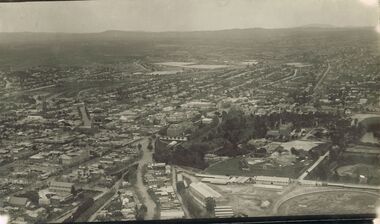 Bendigo Historical Society Inc.
Photograph - AERIAL PHOTOGRAPH OF BENDIGO : 1928
Black and white aerial photograph of Bendigo, 1928. Bendigo Gaol and Rosalind Park in foreground, looking south. On reverse, partly cut off - View over Central B… (Shaw Ross Aviation C.. Printed in Glimpses o….. 1928 Carol Holsworth.bendigo, buildings, historic and archaeological -
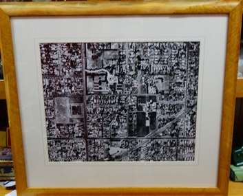
 Bendigo Historical Society Inc.
Photograph - 1.25,000 BENDIGO AERIAL PHOTOGRAPHS
Eighteen undated coloured 1.25,000 army aerial photographs covering Bendigo city and district. [a] -( Similar to A vintage Abrams map reader -Adjustable Stereoscope) -Casella London viewing eye frame with Irving scratched into frame. Another name scratched out also. [b] WW2 Leather pouch stamped Casella London made to hold eye frame.bendigo, utilities, fortuna army mapping division -
 Bendigo Historical Society Inc.
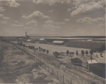
Photograph - BENDIGO ORDINANCE FACTORY COLLECTION: AERIAL VIEW OF FACTORY COMPOUND
... BENDIGO ORDINANCE FACTORY COLLECTION: AERIAL VIEW OF... BENDIGO ORDINANCE FACTORY COLLECTION: AERIAL VIEW OF FACTORY ...Aerial photograph of the development of the ordinace factory , taaken in the 1950s Black & white photo, large format -
Bendigo Historical Society Inc.
Photograph - AERIAL PHOTO FORTUNA VILLA
... aerial view... BENDIGO Streetscape aerial view Large black and white aerial photo ...Large black and white aerial photo taken looking north, foreground Fortuna Villa, on right side site where now is St John hospital, top left garden gully oval. There are three copies (one sepia colour).bendigo, streetscape, aerial view -
Bendigo Historical Society Inc.
Photograph - AERIAL PHOTO OF BENDIGO
... aerial view... BENDIGO Streetscape aerial view Large black and white aerial ...Large black and white aerial photograph of the city of Bendigo.bendigo, streetscape, aerial view -
 Bendigo Historical Society Inc.
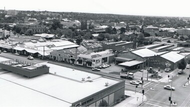
Photograph - AERIAL VIEW BENDIGO, 1995
... AERIAL VIEW BENDIGO...Aerial view of bendigo... PLACE Aerial view of bendigo Peter Hyett Black and white photo ...Black and white photo: Bendigo skyline from St. Pauls, bottom left corner of Williamson St. and Myers St., Williamson St. across centre of photo. Anne Caudle centre left on skyline. Bendigo Base Hospital centre on skyline. ( Noelene Wild - 7.2000 ) In image ' Bruce's Discount Store ' ' Nissan Symes Motors ' ' Furniture Warehouse' Bendigo Bulk Carpets' The Carpet Giants 'Peter Hyettplace, aerial view of bendigo