Showing 859 items matching "agriculture victoria"
-
 Department of Energy, Environment and Climate Action
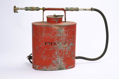
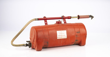
Rega Knapsack, c 1945
Spraying units were manufactured in Australia by REGA Products Ltd. from 1926. REGA established themselves as leaders in the production of agricultural and horticultural spraying machines, including smaller knapsacks. Their metal knapsacks were quickly adapted to a range of applications and were widely used by the Forests Commission and Country Fire Authority (CFA). They were metal and very robust but heavy and uncomfortable to wear REGA was later purchased by the Garrard family and still operate as part of Garrads Pty Ltd. This sprayer was used by the FCV at CreswickThe REGA spray unit includes brass fittings, leather straps with a brass pump handle and adjustable nozzle attached. Adjustable leather straps have "quick release" clips and studs Camm lock lid with chain attachedREGA Creswickforests commission victoria (fcv), bushfire, planned burning, fire pump -
 Department of Energy, Environment and Climate Action
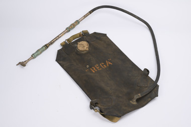
Rega fire knapsack
Spraying units were manufactured in Australia by REGA Products Ltd. from 1926. REGA established themselves as leaders in the production of agricultural and horticultural spraying machines, including smaller knapsacks.Fire knapsack with carry handle Brass pump handle and adjustable nozzle attached.forests commission victoria (fcv), bushfire, planned burning, fire pump -
 Lakes Entrance Historical Society
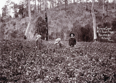
Photograph - Falk Family, Arthur Cooper, 1909c
Black and white photograph of Bertha aged 10 and Gladys aged 16 and Arthur Falk aged 12 standing in their father's potato crop. In the background is a scrub covered steep hill showing saplings remaining after clearing, Kalimna West Victoriagenealogy, agriculture -
 Lakes Entrance Historical Society
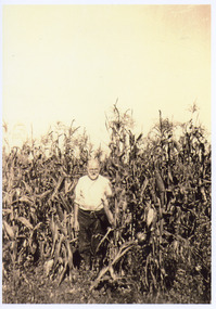
Photograph - Falk Family, 1925 c
Sepia toned photograph of Frederick Louis Falk standing in a tall crop of maize at Kalimna West Victoriagenealogy, agriculture -
 University of Melbourne, Burnley Campus Archives
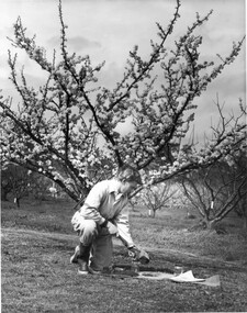
Photograph - Black and white print, Information Branch Victorian Department of Agriculture, Student Taking Soil Samples, c. 1969
... On reverse, "Photograph by Information Branch Victoria..., "Photograph by Information Branch Victoria Department Of Agriculture ...Black and white photograph. Student taking soil samples In the Orchard in Spring.On reverse, "Photograph by Information Branch Victoria Department Of Agriculture Ref. No. D1101.D."students, soil samples, orchard, publicity -
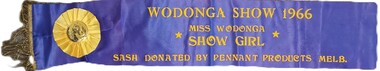 Wodonga & District Historical Society Inc
Memorabilia - Miss Wodonga Show Girl Sash 1966
In 1947 Shire President Cr. Charles F. Pollard called a public meeting for the purpose of discussing the forming of an Agricultural Society to raise funds for the proposed Wodonga Hospital. Cr. Pollard was the inaugural President of the Wodonga Show Society and was joined by seven past Shire Presidents as part of an original 25 member Wodonga Show Society committee. In addition to the committee, there were 150 members of the inaugural Society. The first Wodonga Show was held on Saturday 6 March 1948. The first Sun-News Pictorial Miss Show Girl competition was held in Victoria in 1957, an annual tradition that lasted into the 1990s. Most country shows held heats to find a local winner before the final was judged at the Royal Melbourne Show each year. The first Miss Wodonga Show Girl competition was held in 1958. It was open to all girls between the ages of 16 and 23, born in Australia or naturalised Australians. Judging will be on the following basis of deportment, dress sense, grooming, general appearance, personality. Wodonga Show Society presented a prize to the winner who was accompanied to the final judging on People’s Day at the Melbourne Royal Show. This sash was awarded to Miss Wodonga Show Girl in 1966. The winner of the Senior Section was Ludmilla Bartosz of Wodonga. The Junior Show Girl section was won by Sue Maddison of Bandiana. First prize in the Senior section included this sash, $20 in case and a first class return rail fare to Melbourne for the final judging at the Royal Melbourne Show.A blue sash with gold trim and lettering and a fringe trim.WODONGA SHOW 1966 MISS WODONGA SHOW GIRL SASH DONATED BY PENNANT PRODUCTS MELB.wodonga agricultural society, wodonga show, miss wodonga show girl -
 Department of Energy, Environment and Climate Action
Rega fire knapsack for use with bulldozer
Spraying units were manufactured in Australia by REGA Products Ltd. from 1926. REGA established themselves as leaders in the production of agricultural and horticultural spraying machines, including smaller knapsacks.Plastic fire knapsack usually attached to the back of machinery Brass pump handle and adjustable nozzle attached.REGAforests commission victoria (fcv), bushfire, planned burning, fire pump -
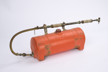 Department of Energy, Environment and Climate Action
Rega fire knapsack for use with bulldozer
Spraying units were manufactured in Australia by REGA Products Ltd. from 1926. REGA established themselves as leaders in the production of agricultural and horticultural spraying machines, including smaller knapsacks.Metal fire knapsack usually attached to the back of machinery Brass pump handle and adjustable nozzle attached.REGAforests commission victoria (fcv), bushfire, planned burning, fire pump -
 Lakes Entrance Historical Society
Book, Meridith Fletcher, Gippsland Heritage Journal, 1996
Life in various areas around Gippsland Victoriaagriculture, land settlement, migrants -
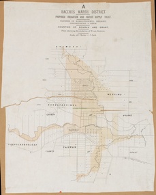 Bacchus Marsh & District Historical Society
Map, Bacchus Marsh District (A). Proposed Irrigation and Water Supply Trust. Plan shewing boundaries of Trust District
The 1886 Irrigation Act in Victoria introduced the first legislation in Australia designed to enable the creation of a detailed scheme for agricultural irrigation. Part of the legislation saw the use of government funds for local irrigation projects. These local projects were managed by local irrigation trusts. The Bacchus Marsh Irrigation and Water Supply Trust was formed in 1889. This map depicts the proposed area of the Trust.Printed paper map of the proposed Bacchus Marsh Irrigation and Water Supply district. Circa 1889. Plan showing boundaries of Trust District. The District lies within the Parishes of Korkuperrimul, Merrimu, Parwan and Gorrockburkchap in the Counties of Bourke and Grant. At the top of the map above its title is the letter 'A; in capital lettering. Scale: 40 Chains = 1 inch.irrigation, water supply, bacchus marsh irrigation and water supply trust -
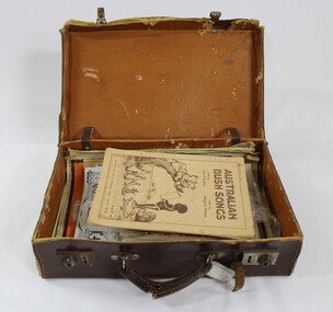 Wodonga & District Historical Society Inc
Booklet - Hamilton-Smith Collection Suitcase with Booklets and other Publications c. early to mid 1900s
The Hamilton-Smith collection was donated by the children of Grace Mary Hamilton-Smith nee Ellwood (1911-2004) and John Hamilton-Smith (1909-1984) who settled in Wodonga in the 1940s. The Ellwood family had lived in north-east Victoria since the late 1800s. Grace’s mother, Rosina Ellwood nee Smale, was the first teacher at Baranduda in 1888, and a foundation member of the C.W.A. Rosina and her husband Mark retired to Wodonga in 1934. Grace and John married at St. David’s Church, Albury in 1941. John was a grazier, and actively involved in Agricultural Societies. The collection contains significant items which reflect the local history of Wodonga, including handmade needlework, books, photographs, a wedding dress, maps, and material relating to the world wars. The ephemeral edition of 'Australian Bush Songs' visible inside the case was published in 1937 in Melbourne by Allan & Co. It contains children's songs drawing on Australian themes which were popular and well-known in the 1930s. This item has well documented provenance and a known owner. It forms part of a significant and representative historical collection which reflects the local history of Wodonga. It contributes to our understanding of social and family life in early twentieth century Wodonga, as well as providing interpretative capacity for themes including local history and social history.A brown vinyl suitcase containing song books, periodicals and magazines c. 1920s - 1930s.hamilton-smith, ellwood, hamilton-smith collection, wodgona, books, reading, songs, song, singing, children, child -
 Bacchus Marsh & District Historical Society
Map, Plan of Land at Bacchus Marsh, the Property of James Young, 1868
James Young was a prominent businessman, land owner and public figure in the early colonial period of Bacchus Marsh. In February 1868 he offered for sale through the agent W. Anderson 38 blocks of land which ran from the Lerderderg RIver westwards beyond Gisborne Road in the vicinity of the present day Masons Land. The land for sale was described as, 'unsurpassed Agricultural Land, in the immediate vicinity of Bacchus Marsh, varying in size from 2 to 12 acres each'. The sale notice in the Bacchus Marsh Express of 1st February 1868 page 2, also noted that, ' Plans can be seen at Mr. Young's Border Mills Store, and at the Border Inn'. One of the largest and most important land sales in the early colonial period of Bacchus Marsh.A single page paper map showing 38 blocks of land for sale in 1868 in the vicinity of Masons Lane Bacchus Marsh. Scale 11 chains to 1 inch. The map is pasted into a bound volume containing 76 maps or plans in total. High resolution digital image stored on BMDHS computer network. land sales bacchus marsh, bacchus marsh victoria maps, james young 1816-1871, masons lane bacchus marsh land sales -
Lakes Entrance Historical Society
Book, Hales Jeremy, Maffras Beet Sugar Industry 1894-1948, 1998
The story of the Beet Sugar factory at Maffra Victoria from its beginnings in 1894 the problems encountered and the demise of the industry after WW2 The history of earlier Victorian unsuccessful into establishing the industry are mentioned Maffra beet sugindustrial, agriculture -
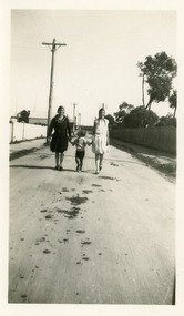 Lakes Entrance Historical Society
Photograph - Taylor/Todd, 1935 c
Black and white photograph of Della Taylor later Mrs Tommy Todd with M Gray and small child walking in a street in Lakes Entrance Victoriaagriculture, genealogy, transport -
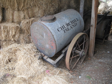 Churchill Island Heritage Precinct
Functional object - Furphy Water Cart, 1929
The Churchill Island collection includes objects from the late 1800s. The collection is presented in sets and series, of which this object represents the Buckley era. The family-owned Furphy company has been manufacturing agricultural equipment in Kyneton and then Shepparton in Victoria from the 1860s to the present day. In the late 1800s the company developed the Furphy Water Cart to help farmers transport water to and from and around their properties - especially in time of drought.Cylindrical tin water cart with small access lid on top, unpainted and mounted onto a two-wheel cartCHURCHILL ISLAND Furphy water cart / Furphy & Sons, Sheppartonfarm machinery, water, horse drawn, furphy, churchill island -
 Lakes Entrance Historical Society
Photograph - McCrae's Lime Kiln, 1999
Site of lime burning operations from 1870's. Lime burnt for agricultural purposes. Cocky Roberts was using lime in his glass making business at Lakes Tyers.Colour photograph of the McCrae Lime Kiln site east side shows work site now encroached on by bushland. Toorloo Arm Victoriahistoric site, local history -
 Lakes Entrance Historical Society
Photograph, 2000 c
Photo taken prior to big auction of machinery, and closure of business.Colour photograph of G K & B Stephenson's Truck and Tractor Sales and Service garage, showing tidy business premises, agricultural machinery on display, and two fuel bowsers on Princes Highway, Johnsonville Victoriaretail trade, transport -
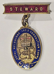 Melbourne Royal
Badge, The Royal Agricultural Society of Victoria, 1953
... on the 'cushioning' and "E[II]R". Badge The Royal Agricultural Society ...In the 1953, the Show held a special Coronation Show in honour of the coronation of Queen Elizabeth II.A badge consisting of a badge attached to a pin, and an oval shape hanging from the bar. The base of the badge is gold with inserted colour in the obverse. The bar is rectangular with concave sides and red infill around text ("STEWARD"). The oval has a dark blue outline with gold text and a belt-design similar to the RASV Speed the Plough Logo. Inside the outline is mostly gold. The background is textured, and on top of that is a crown design with red colouring on the 'cushioning' and "E[II]R".[obverse bar] STEWARD [obverse oval] ROYAL MELBOURNE 1953 CORONATION SHOW / ER II [reverse oval] K.G. LUKE / MELB /1953 melbourne royal show, melbourne royal show, royal melbourne coronation show, queen elizabeth ii, badge, steward, officials, uniform -
University of Melbourne, Burnley Campus Archives
Newspaper - Newspaper Cutting, The Herald, Victoria - The Garden State, 1989
4 page liftout in "The Herald" 05.04.1989. "Victoria the Garden State." P4 contains article, "Ask Them a Question: They've got the Answers," by Robert H. Taylor, Assistant Director of Agriculture. Advisory Centre to be developed at Burnley Gardens.the herald, robert h. taylor, burnley gardens, plant research institute, plant research laboratory, victoria the garden state, garden questions -
 Eltham District Historical Society Inc
Photograph, C.S. Wingrove, Secretary, Eltham District Road Board 1858-1871; Shire Secretary, Shire of Eltham 1871-1904, 1858-1871
Charles Symons Wingrove, J.P. (1829-1905) arrived in Victorian in 1851. He had trained as an engineer, but tried his luck on the goldfields. In 1857 he was appointed as Secretary to the Eltham District Roads Board only one year after its foundation. He was to hold the position with the Board and later the Eltham Shire Council for total of 47 years. He also held the position of engineer for a large part of this period. During part of this time he was also secretary to the Heidelberg Shire Council. Over this period he was responsibly for an area stretching from Clifton Hill to Healesville, along the northern bank of the Yarra River. Other positions included Secretary to the Victorian Agricultural Society over along period.Wingrove was a main figure in the Municipal Association of Victoria. By the time he retired he was recognized as the “Grand Old Man” of Victorian local government. In 1858 Wingrove had a brick cottage built in Main Road near the State School and he lived here until his death. One room was uded as the Board and Council office. His descendants owned the house until 1974. It was later used as a psychiatric clinic. The park opposite the cottage has been named Wingrove Park in his honour. He is buried at St Helena with other members of his family. Age (Melbourne, Vic. : 1854 - 1954), Tuesday 18 July 1905, page 5 ABOUT PEOPLE. A conspicuous figure in northern municpal history, Mr. Charles Symons Wingrove, has passed away. He was for many years secretary and engineer for the shire of Eltham, and prior to the formation of the shire held the position under the old road board, his official connection with the district dating from beyond 1857. For about twelve years he also filled the position of shire engineer for Heidelberg council while retaining his other post, and the immense territory under his professional control, reaching from the boundary of Collingwood up to Healesville, was a matter of fatherly pride and interest to him. He arrived in Victoria in 1851, and was 76 years of age at his death. Mr. Wingrove retired from the position in the Eltham council only about a year ago. The interment will take place in St. Helena Cemetery, near Eltham township, today. Secretary, Eltham District Road Board 1858-1871 Secretary for the Shire of Eltham 1871-1904. Nearly 50 years service to the local community. For about twelve years he also filled the position of shire engineer for Heidelberg council. Reproduced Page 137 "Pioneers & Painters" This photo forms part of a collection of photographs gathered by the Shire of Eltham for their centenary project book,"Pioneers and Painters: 100 years of the Shire of Eltham" by Alan Marshall (1971). The collection of over 500 images is held in partnership between Eltham District Historical Society and Yarra Plenty Regional Library (Eltham Library) and is now formally known as the 'The Shire of Eltham Pioneers Photograph Collection.' It is significant in being the first community sourced collection representing the places and people of the Shire's first one hundred years.Digital image Print 25 x 20 cmc.s.wingrove, charles symons wingrove, eltham district road board, sepp, shire of eltham pioneers photograph collection, shire secretary, wingrove cottage, pioneers and painters, shire of eltham, councilor, municipal officer -
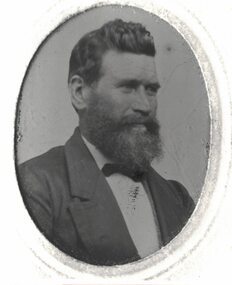 Linton and District Historical Society Inc
Photograph, Ewen Rankin
Ewen Rankin migrated from Scotland to Victoria in 1852 with his parents and brothers and sisters. He became an important figure in Linton, being involved with both agricultural and mining activities. He was an Elder of the Presbyterian Church. He married Anna Woods in 1874 and they had several children, who also went on to become Linton identities.Black and white image of a man with a short beard. He is wearing a jacket and bow tie.ewen rankin -
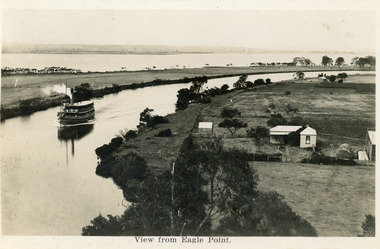 Lakes Entrance Historical Society
Postcard - Eagle Point, 1930 c
Black and white postcard S S Gippsland in Mitchell River, travelling towards Bairnsdale, silt jetties extending eastwards small farm, farm house and sheds on right. Jones bay in Middle distance beyond silt jetty, taken from Eagle Point Bluff. Bairnsdale VictoriaView from Eagle Point. ships and shipping, waterways, agriculture, houses -
 Lakes Entrance Historical Society
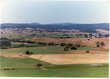
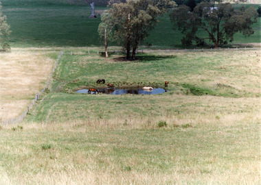
Photograph - Mossiface Flats, Tambo Shire, 1994
Also second identical copyColour photograph of the Mossiface Flats, near Bruthen, shows paddocks of the rich river flats, timbered foothills in the distance, with mountain range behind. Some paddocks have been mown for grass hay. Farm buildings in foreground and background. Dam in foreground. Bruthen Victoriaanimals, agriculture, vegetation, topography -
 Lakes Entrance Historical Society
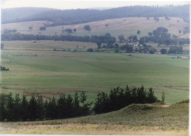
Photograph - Sarsfield Flats, Tambo Shire, 1994 c
Also second identical copyColour photograph of Sarsfield Flats. Distant view of cattle grazing and farm buildings, foothills in background, and glimpse of mountains. Pine trees in the foreground. Bruthen Victoriaagriculture, topography -
 Lakes Entrance Historical Society
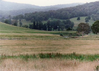
Photograph - Timbarra, Tambo Shire, 1994 c
Colour photograph of grazing country in the Timbarra region, showing well grassed paddocks in foreground farm buildings in valley wooded foothills in background. Timbarra Victoriaagriculture, primary industry, animals -
 Lakes Entrance Historical Society
Photograph, Tambo Shire, 1994 c
Also second identical copyColour photograph of a rural view near Buchan, shows five horses in and around a dam, farming building in distance glimpsed through trees. Bruthen Victoria topography, agriculture -
 Lakes Entrance Historical Society
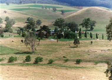
Photograph - Buchan Station, Tambo Shire, 1994 c
Also second identical copyColour photograph of Buchan Station, shows farming buildings situated among trees, both cultivated and uncultivated paddocks around property, forested hills in background. Buchan Victoriaagriculture, animals, topography -
 Lakes Entrance Historical Society
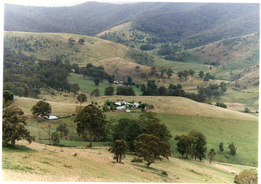
Photograph - Gillingal Station, Tambo Shire, 1994 c
Also second identical copyColour photograph of Gillingal Station, showing the farm buildings situated on a hillside and surrounded by rising hill country and fertile valleys, cattle grazing in home paddock. Buchan Victoriaagriculture, primary industry -
 Lakes Entrance Historical Society
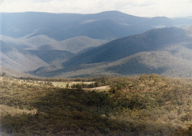
Photograph - Suggan Buggan, Tambo Shire, 1994 c
Also second identical copyColour photograph of the scenery in Suggan Buggan, showing very heavily forested mountainous country, a small area of cleared land centre left foreground. Suggan Buggan Victoriasettlement, agriculture, topography -
 Federation University Historical Collection
Book, Final recommendations Ballarat Study Area Land Conservation Council, Victoria, 1982, 1982
Yellow soft covered report of 95 pages . The contents of the report include: Parks, reference areas, wildlife reserves, water production, harwood production, softwood production, flora Reserves and Flora and Fauna reserves, bushland reserves, historic area and reserves, rivers and streams, Roadside conservation and Highway parks, Education areas and School Plantations, Lake Reserves, geological reserves, recreation, scenic reserves, agriculture, mineral and stone production, utilities and survey, township land, Uncommitted Land, military training, other reserves and public land. Maps include: The Study area 1: 250 000 Supplementary Mapsland conservation authority, ballarat, endowment plantations, pine plantations, langi ghiran state park, mount buangor state park, enfield state park, ballarat-creswick regional park, rossbridge, black lake, flax mill swamp, dereel lagoon, lake bolac, lake wongan, langi ghiran reservoir, gong gong reservoir, pincotts reservoir, beales reservoir, wilsons reservoir, moorabool reservoir, korweinguboora, korweinguborra reservoir, learmonth bores, sago hill, illabarook reservoir, ballarat water commission, dunneworthy, mount cole, mont lonarch, ben major, waterloo, trawalla, linton, ross creek, canadian, shepherds flat, lal lal, mount doran, raglan, chute, carngham, buninyong, watsons hill, enfield, cape clear, illabrook, rokewood junction, mount warrenheip, nerrina, jubilee, golden stream, australasian deep lead mine, happy valley school, piggoreet, berringa, bulldog, ballarat common, wildlife, water, timber, flora, rivers, geology, agriculture, warrenheip, biodiversity