Showing 11784 items
matching geo-map
-
 Tatura Irrigation & Wartime Camps Museum
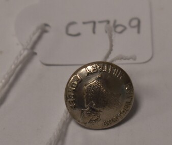
Button, Stokes and Son
Issued to Sister Kathleen Heaphy of Australian Army Nursing service. Sister Heaphy was attached, for part of her service, to 28 Camp Hospital Internment camp 1.round silver metal button with a metal shank. Crown and map of Australia and wording around the circumference. Australian Military Forces A crown and map of Australia Stokes and Sonsaustralian army nursing service, sister kathleen heaphy, 28 camp hospital internment camp 1, brass buttons -
 Creswick Campus Historical Collection - University of Melbourne
Document, Forests Commission Victoria, A list of rare, very localised and endangered indigenous plants of Victoria, c.1982
1 Booklet and 29 maps in boxed set.Maps and Booklet -
 Warrnambool and District Historical Society Inc.
Map, Department of Lands and Survey (Lithographers), Caramut township, 1938
This map of the township of Caramut was produced in 1938 but shows the original land owners of each town allotment and of the surrounding area. The size of all the allotments and the date of the original purchase are also shown. Caramut is a Victorian Western District town on Mustons Creek on the Hamilton Highway 48 kilometres from Warrnambool. This map was used by Rolf Crawley when he was the engineer for the Shire of Warrnambool from 1935 to 1968. The annotations on the map have probably been made by Rolf Crawley as they refer to the records and letter books of his father, John William Crawley, Junior (Shire of Warrnambool Engineer 1895 to 1935). Both Rolf Crawley and his father, John had private businesses as architects, surveyors and engineers and the map could have been used in connection with both their official Shire duties and their private businesses. The last owner of the map was the surveyor, Michael Hand who took over the business of Rolf Crawley in the late 1960s. This map is of great interest firstly because it has all the historical details of the land first purchased in the town of Caramut and area and secondly because it came from the office of Rolf Crawley, the engineer for the Shire of Warrnambool from 1935 to 1968. This is a buff-coloured paper map with a cloth backing. The map details are in black and white print. There are some handwritten red and black annotations on the map. “Town of Caramut Parish of Caramut County of Villiers’town of caramut, john william crawley junior, warrnambool, rolf crawley, warrnambool -
 Bendigo Military Museum
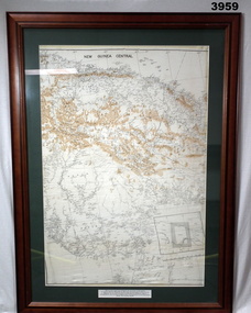
Map - MAP, NEW GUINEA FRAMED, C. 1941 onwards
Map of central section of New Guinea. Black print on white background with mountain ridges in tan. Map is mounted with green border. Brown wooden frame, glass front, white cardboard backing with wire hanging strap on back. Map prepared under the direction of RAAF Headquarters.Printed in black top centre: “NEW GUINEA CENTRAL” Printed on border under map: “These escape maps were carried in the zip pocket of life jackets by fighter pilots in WW2. This map was presented to A.S.R. on 12.7.79 by Councillor Ian McKenzie, Mayor of Eaglehawk, who served as a fighter pilot in 78th SDN in the SW Pacific area during 1943-44.”map, new guinea, central, raaf -
 Bacchus Marsh & District Historical Society
Map, Village allotments, Parish of Myrniong, County of Bourke
Myrniong is a village 9 kilometers west of Bacchus Marsh. Prior to 1863 the area was known as Blow's Flat. This map which was produced in 1903 and according to the catalogue record of this map held at the State Library of Victoria was based on an earlier map created in 1861. The early layout of streets for the village of Myrniong can be seen on this map. The streets shown are, Main Street, Hardy Street, Blow Street, Myrniong Street, Shuter Street, and Blackwood Street. An area marked as a reserve for a school can be seen between Hardy Street and Main Street.A single page paper map. A cadastral parish map of Myrniong in Victoria, showing numbered land allotments. Photo-lithographed at the Department of Lands & Survey, Melbourne, in 1903. Based on an original map created in 1861. The map is pasted into a bound volume containing 76 maps or plans in total. High resolution digital image stored on BMDHS computer network. Surveyed by John Hardy, Surveyor ; photo-lithographed at the Department of Lands & Survey, Melbourne by T.F. McGauran, 24.12.03myrniong parish plan, myrniong parish maps -
Clunes Museum
Pamphlet - TOUR AND MAP, RICHARD AITKEN, TALBOT WALKING TOUR, 1988
PUBLISHED FOR BICENTENNIAL COMMEMORATION 1988TALBOT WALKING TOUR AND MAP. PUBLISHED BY TALBOT AND CLUNES HERITAGE PROJECT. WRITTEN BY RICHARD AITKEN, 1988PHOTO OF TALBOT TOWN HALL; HISTORY; DESCRIPTIONS OF BUILDINGS AND MAPtalbot, tour, map, 1988, aitken -
 Bendigo Military Museum
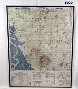
Map - MAP, MOUNTED, US Army 1966, Map information as of 1965
Map - colour map titled "XA BINH BA, VIETNAM" Scale 1:50,000. Map depicts "ENEMY INSTALLATIONS 1 APR - 22 OCT 68, CONFIDENTIAL" Map mounted on sheet of timber, sealed with a clear varnish.mapping, vietnam war -
Clunes Museum
Map - MAP OF CLUNES, FENTON CHARLES
THESE MAPS WERE SOLD IN CLUNES MUSEUM PRIOR TO TH REDEVELOPMENTOF THE WAREHOUSE BY HEPBURN SHIRE COUNCIL. MAPS WERE SOLD FOR $ 1.504 COPIES OF MAP OF CLUNES 1987map, clunes 1987, charles fenton, map of clunes -
 Peterborough History Group
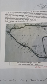
Document - Peterborough survey, Heytesbury District
About Peterborough town and the surrounding Council districts, coastal survey and mapshistory of the development of the townMaps, photocopiesflaxman hill, peterborough history, heytesbury, peterborough 3270 -
 Victorian Aboriginal Corporation for Languages
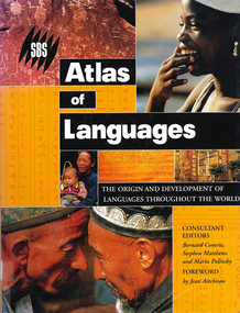
Book, Bernard Comrie, SBS SBS atlas of languages : the origin and development of languages throughout the world, 2003
Over 30 full-colour maps, over 40 of the world?s major languages, language family trees, over 100 stunning full-colour photographs. A full glossary of linguistic terms.Maps, colour illustrations, colour photographslinguistics, maps, atlases -
 Kiewa Valley Historical Society
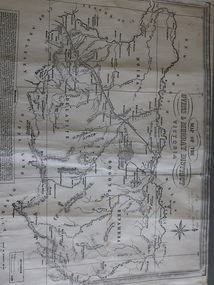
Map of the Ovens and Murray District of Victoria
The map features Beechworth and its history.This map features the north-east and in particular, Beechworth where residents of the Kiewa Valley may have shopped or visited for appointments.Black and white map with references to roads and gold. The centre of the map is Beechworth and in the bottom left side of the map is the heading Beechworth with 12 lines of print of information regarding Beechworth. The Kiewa Valley is not identified.beechworth -
 Federation University Historical Collection
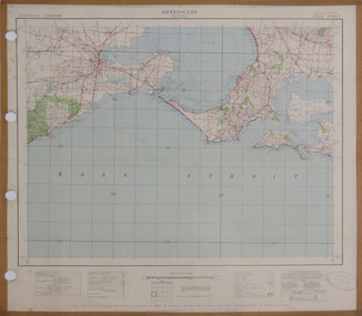
Map, Queenscliff, 1942, 1942
Two copies of printed colour map on paper showing Queenscliff and surrounds"This map in an official document, if found, it must be handed in to the nearest military headquarters or police station."queenscliff, portsea, point nepean, point lonsdale, barwon heads, geelong, corio bay, port phillip bay -
 Ballarat Tramway Museum
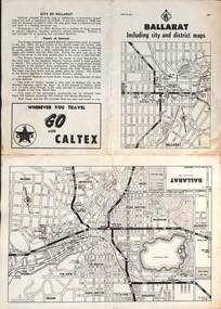
Map, RACV - Royal Automobile Club of Victoria, "Ballarat including city and district maps", 10/1961
Shows the central part of Ballarat, Ballarat Outlets, streets, principal attractions, Ballarat and district maps and information. Has the tram lines shown dotted, does not run out to Sebastopol or the Lydiard St North terminus. Each map in the bottom left-hand corner has the number "1061", possibly indicating the date. Has notes on the City, points of interest, and an advertisement for Caltex. See item 4929 for a larger version dated 1966. Yields information about the extent of Ballarat in the early 1960's shows the tram lines and other rail lines in the district. Four fold map printed on white paper, titled "Ballarat including city and district maps" - Map No. MAP 15.314 and dated 10-61. Produced by the RACVmap, tranways, ballarat, racv, railways -
 Melbourne Tram Museum
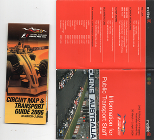
Booklet, Metlink, "Information for public transport staff - 2006 Formula 1 Australian Grand Prix", 2006
Gives details of event for train, tram and bus crews, event program and transport map, including shunting details, announcements, bus replacement services, electric or automatic points, route alterations. On the back cover has contact telephone numbers and web addresses - Published by Metlink. Fold out map gives a detail map of the course, locations for transport and details of the event - published by the Grand Prix corporation. Yields information the 2006 Grand Prix event at Albert Park.Set of 2 items - both within a clear plastic envelope. 1 - booklet 40 pages with foldout map centre stapled 2 - 16 fold map - circuit map and transport guide tramways, grand prix, metlink, formula 1, albert park -
 Greensborough Historical Society
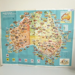
Map, International Harvester, Australia. Land of tomorrow, 1965_
This 1960s map of Australia shows areas of economic development at that time.Colour map of Australiaaustralia economic development, international harvester -
 Creswick Campus Historical Collection - University of Melbourne
Map, Creswick, 1943
Dept of Lands and Survey map of Creswick and county of Talbot. 2 linen backed sheets rolled into white cardboard cylinderMaps -
 Federation University Historical Collection
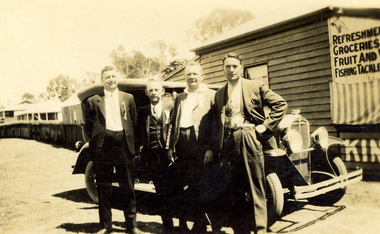
Photograph - Photograph - Black and White, Pat McNamara, Officials from the Australian Band Championships, Maryborough, Queensland, 1932, March 1932
Frank Wright was a renown resident of Smeaton, where he was born. He lived at Laura Villa, and attended Smeaton State School. His father William was a gold miner and his mother's name was Sarah. Their family won many singing and instrumental awards. Frank was tutored by Percy Code and was awarded a gold medal for the highest marks in the ALCM examinations in the British Colonies at the age of seventeen years. He became the Australian Open Cornet Champion by the age of eighteen. A year later, Frank conducted the City of Ballarat Band, and later the Ballarat Soldiers’ Memorial Band. He formed the Frank Wright Frisco Band and Frank Wright and his Coliseum Orchestra. These bands won many South Street awards, and Frank as conductor won many awards in the Australian Band Championship contest. In 1933 Frank Wright sailed to England to conduct the famous St Hilda’s Band and was later appointed Musical Director of the London County Council, where he organized many amazing concerts in parks, in and around the London district. He was made Professor of Brass and Military Band Scoring and conducted at the Guildhall of Music and Drama. Frank was often invited to adjudicate Brass Band Championships around Europe, in Australia, including South Street and in New Zealand. The Frank Wright Medal at the Royal South Street competition is awarded to an individual recognized as making an outstanding contribution to brass music in Australia.Black and white photograph of four men dressed in suits standing in front of an old car. In the background is a shop to the right and a fence with buildings to the left. The men are Joe Foster, Geo Cousins, Bill Caught and Frank Wright. The place is Maryborough, Queensland.Written in pencil on back - Joe Foster sec Q.B.A., Geo Cousins ref Q.B.A., Bill Caught ref Q.B.A., Frank Wright adjudicator, Australian band championships, Maryborough, Queensland, March 1932 Printed on back - Printed by Pat McNamarafrank wright, geo cousins, joe foster, bill caught, australian band championships, maryborough queensland -
Beechworth Honey Archive
Map- Chiltern/Barnawartha
(4x) Map centred on Chiltern and Barnawartha. Shows Murray River, Hume Highway, Chiltern- Barnawartha Rd and Chiltern- Rutherglen Rd. Scale 1:50,000. Paper is white on back, yellow on front.Map labelled 'Albury series R652' Some markings in red and blue on some maps- blue writes '74-75'map, chiltern, barnawartha, paper, beechworth honey -
Victorian Aboriginal Corporation for Languages
Book, RMW Dixon, Australian languages: their nature and development, 2002
Very comprehensive technical linguistic introduction to the Australian language family, a follow-up to Dixon?s ?The Languages of Australia? (1980). Numerous maps, isoglosses, tables, comparative grammar, phonology, semantics, etc. 1. The language situation in Australia 2. Modelling the language situation 3. Overview 4. Vocabulary 5. Case and other nominal suffixes 6. Verbs 7. Pronouns 8. Bound pronouns 9. Prefixing and fusion 10. Generic nouns, classifiers, genders and noun classes 11. Ergative/?accusative morphological and syntactic profiles 12. Phonology 13. Genetic subgroups and small linguistic areas 14. Summary and conclusion.Mapslinguistics, language surveys -
 Eltham District Historical Society Inc
Book, Melway Great Melbourne street directory including Geelong, Phillip Island Healesville, Bellarine & Mornington Peninsulas, 1998
25th edition. Coloured detailed maps accessed by a street or location index. Cover: (Includes) New Southbank map including Crown Complex, enlargements of Footscray and Kensington, bike paths, walking tracks & horse trails, latest public transport information, South east Australia tours maps, Vic Roads new route numbers, map of Australia1 atlas (22, 772 p.) : col. maps ; ISSN 03113957streets, maps, roads, melbourne -
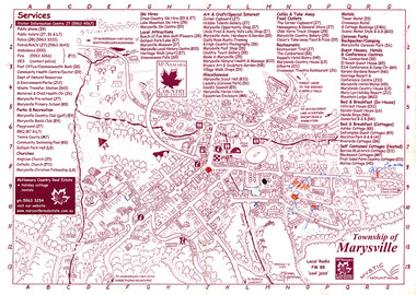 Marysville & District Historical Society
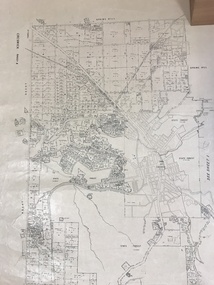
Map (Item) - Information map, Michael Hampton, 2000
An information map of the township of Marysville. This map was produced by McNamara Country Real Estate in 2000. The artist who drew the map was named Michael Hampton.An information map of the township of Marysville.MICHAEL HAMPTON/ 2000 VERSION 1:2/ 01/01marysville, victoria, australia, tourist map, information map, mcnamara country real estate, michael hampton -
 Greensborough Historical Society
Map - Map (Copy), C. Hodgkinson, District Surveyor et al, Parish of Yan Yean 1856: Village site during construction of the Yan Yean Reservoir, 1978
Copy of map part Sec. 13, Parish of Yan Yean 1856, Map 3, Village site... Scale: 8 chains to 1 inch. Drawn by C. Hodgkinson, District Surveyor, redrawn by A. R. Blair 1978. 1 p. photocopy of map. yan yean reservoir, yan yean -
 Warrnambool and District Historical Society Inc.
Map - Tourist Map Collection: Warrnambool & District Tourist Maps, Philprint, Warrnambool
This is a diverse collection of Tourist Maps for the Warrnambool & District area. [.1] From information on this guide it dates from the mid 1970's. It appears to not have been commercially printed and includes details of attractions no longer operating in Warrnambool such as Warrnambool Aquarium and the Oasis Reptile Park and Zoo. [.2] Commercially printed Warrnambool tourist map (c mid 1980's) surrounded by advertisements for local businesses. [.3] Commercial printed December 1991 tourist map of Warrnambool and District includes a competition entry form [.4] Commercially printed tourist map aimed at children [.5] Walking map of Warrnambool and District [.6] Commercially printed Warrnambool tourist map (c mid 1980's) surrounded by advertisements for local businesses. This collection of maps from the mid 1970's to early 1990's gives an insight into what was available to assist tourists find their way around Warrnambool and District. They include advertisements for business operating during this period and include lists of available accommodation, eateries, and tourist attractions.[.1] Tourist Attractions In and Around Warrnambool two foolscap pages with two sides of type written information of local and district attractions. There is a Warrnambool City map with points of interest marked and a hand drawn district map; [.2]Commercially printed grid map of Warrnambool City surrounded by advertisements from local businesses. Reverse side has a district map and a map of the Warrnambool CBD surrounded by advertising. [.3] Brochure including small grid maps of Warrnambool and district listing accommodation providers and places of interest. Stylised blue & bright green design of Norfolk pines and sea. [.4] Children's treasure hunt map to Warrnambool There are two examples, one with blue edging (Jan 1986) and one with red edging (Aug 1993) Both have a circular logo with a stylised whale and lighthouse [.5] Walking maps of Warrnambool blue printed photo of four tourists walking coastline on the front cover. [.6] Commercially printed grid map of Warrnambool with a bright yellow inset of Warrnambool CBD main shopping centre. The map is surrounded by advertising for local businesses.warrnambool, tourist maps, warrnambool businesses, warrnambool accommodation -
 Bacchus Marsh & District Historical Society
Map, Allotments in the Village of Rowsley, Parish of Gorrocburkghap, County of Grant c.1856
Rowsley is a locality 11 kilometers south-west of Bacchus Marsh. The date of this map is uncertain. A very similar map held by the State Library of Victoria (SLV) contains slightly more information than this copy and is dated as an 1856 map. SLV reference: 'Allotments in the Village of Rowsley, Parish of Gorrocburkghap, County of Grant', by T. Nixon, Assistant Surveyor, May 1856 ; Surveyor General’s Office, July 18 1856 (lithographed by R. Meikle). (1856). Melbourne: Surveyor General’s Office. MAPS 820 BJE 1837- ROWSLEY 1856. A single page paper map. A cadastral map of the Village of Rowsley in Victoria, showing numbered land allotments. 57 allotments are shown on the map and some areas set aside as reserves. Allotments 8, and 10-16 are outlined in red ink and allotment 9 has a cross in red ink on it. The map is pasted into a bound volume containing 76 maps or plans in total. High resolution digital image stored on BMDHS computer network. rowsley victoria history, rowsley victoria maps -
Beechworth Honey Archive
Map- Beechworth
Compiled from 1972 aerial photography. Printed in 1977.Map centred on Beechworth. SHows Beechworth toen, Wooragee, Reids Creek, Woolshed Falls and Lake Kerford. Scale 1:25,000 Printed colour on paper.Map labelled Reids Creek. No. 8225-3-1.map, beechworth, wooragee, reids creek, woolshed falls, lake kerford, aerial photography, paper, beechworth honey -
 Ringwood and District Historical Society
Map, Plan of the Parish of Warrandyte County of Evelyn - 1841
Blueprint copy of Survey Map W27 detailing original Selectors' names and property locations between Yarra Yarra River (Warrandyte) and Mullum Mullum Creek (Ringwood). List of Parish map references including property bearings, distances in Links, and markings on trees. Pound Bend area of Warrandyte marked as Reserve For Aborigines. Descriptive remarks include areas marked "scrubby, flat, sandy soil". Several other references faded and illegible.(Map) by T.H. Nutt Feb 3 1841. -
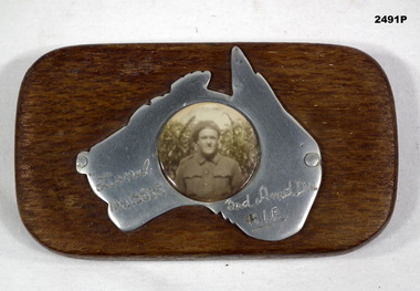 Bendigo Military Museum
Memorabilia - PHOTOGRAPH WW2, Post WW2
The soldier is Lionel Clarence Younghusband, initial enlistment No N199216, transferred to AIF No NX115868 age 22 years on 7.9.1942, date of death listed as 14.7.1943 while serving in 3rd ARMD DIV.Black & white photograph mounted on polished map of Australia mounted on timber rectangular stand. Photograph of a soldier in uniform.Hand inscribed on map - “Lionel NX115868 / 3rd Amd Div / AIF”photography-photographs, military history - souvenirs -
 Peterborough History Group
Document - Survey of Town of Peterborough, 2014
Proclamation of road district and Shires, Map of original town blocks and ad for SaleDisplays original township settlement and layoutPhotocopies, copies of maps, peterborough history, peterborough 3270 -
Whitehorse Historical Society Inc.
Map, Shire of Boroondara, Parish of Nunawading, 1904
Photocopy of printed map extending from Camberwell to Middleborough Road.Photocopy of printed map extending from Camberwell to Middleborough Road. note on verso: From a book of maps dated 1904.Photocopy of printed map extending from Camberwell to Middleborough Road. maps, shire of boroondara, parish of nunawading -
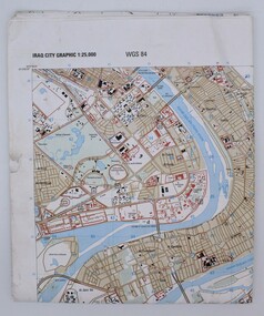 Montmorency/Eltham RSL Sub Branch
Map, Baghdad
Prepared and published by the National Imagery and Mapping Agency Copyright 2003 by the United States GovernmentPaper, coloured The map is of Baghdad Iraq city Graphic 1:25,000. WGS 84 Edition 11- NIMA Series K941 Sheet 4 Map information as of 2001map