Showing 1838 items
matching inches
-
 Ringwood and District Historical Society
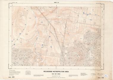
Map - Melbourne Metropolitan Area Base Map Series, Sheet 215 - Ringwood area, 1967
Map prepared by Dept of Lands and Survey and MMBW from State Aerial Survey June 1957 and Cadastral Survey information July 1967. This sheet comprises parts of Municipalities of Doncaster & Templestowe, Nunawading and Ringwood, and Parishes of Nunawading and Warrandyte.Scale: 400 feet to 1 inch. Contours at 5 feet vertical interval. By Authority: A.C. Brooks, Commonwealth Printer, Melbourne. -
 Ringwood and District Historical Society
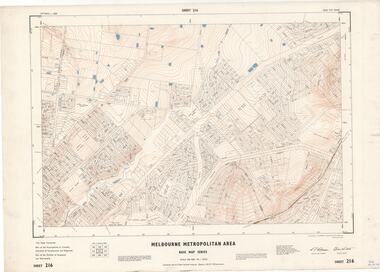
Map - Melbourne Metropolitan Area Base Map Series, Sheet 216 - Ringwood area, 1967
Map prepared by Dept of Lands and Survey and MMBW from State Aerial Survey June 1957 and Cadastral Survey information July 1967. This sheet comprises parts of Municipalities of Croydon, Doncaster & Templestowe, and Ringwood, and Parishes of Ringwood and Warrandyte.Scale: 400 feet to 1 inch. Contours at 5 feet vertical interval. By Authority: A.C. Brooks, Commonwealth Printer, Melbourne. -
 Ringwood and District Historical Society
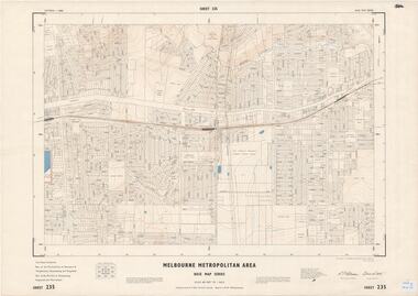
Map - Melbourne Metropolitan Area Base Map Series, Sheet 235 - Ringwood area, 1960
Map prepared by Dept of Lands and Survey and MMBW from State Aerial Survey June 1957 and Cadastral Survey information August 1960. This sheet comprises parts of Municipalities of Doncaster & Templestowe, Nunawading and Ringwood, and Parishes of Nunawading, Ringwood and Warrandyte.Scale: 400 feet to 1 inch. Contours at 5 feet vertical interval. By Authority: A.C. Brooks, Commonwealth Printer, Melbourne. -
 Ringwood and District Historical Society
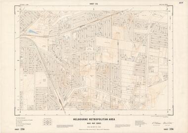
Map - Melbourne Metropolitan Area Base Map Series, Sheet 236 - Ringwood area, 1961
Map prepared by Dept of Lands and Survey and MMBW from State Aerial Survey June 1957 and Cadastral Survey information May 1961. This sheet comprises parts of the Municipalities of Croydon and Ringwood, and Parishes of Ringwood and Warrandyte.Scale: 400 feet to 1 inch. Contours at 5 feet vertical interval. By Authority: A.C. Brooks, Commonwealth Printer, Melbourne. -
 Ringwood and District Historical Society
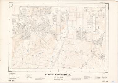
Map - Melbourne Metropolitan Area Base Map Series, Sheet 255 - Ringwood area, 1963
Map prepared by Dept of Lands and Survey and MMBW from State Aerial Survey December 1956 and Cadastral Survey information May 1963. This sheet comprises parts of the Municipalities of Ferntree Gully, Nunawading and Ringwood, and Parishes of Nunawading, Ringwood and Scoresby.Scale: 400 feet to 1 inch. Contours at 5 feet vertical interval. By Authority: A.C. Brooks, Commonwealth Printer, Melbourne. -
 Ringwood and District Historical Society
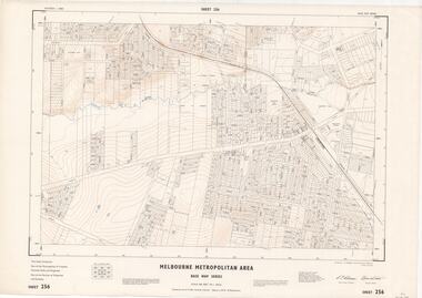
Map - Melbourne Metropolitan Area Base Map Series, Sheet 256 - Ringwood area, 1962
Map prepared by Dept of Lands and Survey and MMBW from State Aerial Survey December 1956 and Cadastral Survey information December 1962. This sheet comprises parts of the Municipalities of Croydon, Ferntree Gully, and Ringwood, and Parishes of Ringwood and Scoresby.Scale: 400 feet to 1 inch. Contours at 5 feet vertical interval. By Authority: A.C. Brooks, Commonwealth Printer, Melbourne. -
 Ringwood and District Historical Society
Map - State Aerial Survey, Dandenong Ranges Area, Parishes of Warrandyte and Ringwood - 1956
Map of central and southern areas of Ringwood and part of Ringwood East and Heathmont compiled by Dept of Lands and Survey, July 1956, from aerial photographs and Cadastral Survey information. Subsequent hand-drawn addition of streets showing layout of "Township of Ballyduffy Estate 1858-60", an earlier proposed subdivision that did not eventuate. (See attached 5009b Ballyshanassy_ Melbourne’s lost suburb.pdf for Ballyduffy historical naming relevance). Ballyduffy Estate streets include City Road, West Prussia Road, Duffy Street, Ireland Street, Evans Street, Victoria Street, Regina Street, Short Road, Prussia Road, Duffy Street East, Ireland Street East, Evans Street East, Chapman Street. Misc Topo 93 Sheet 22, Ringwood A4B2. Scale: 4 chains to 1 inch. Contour interval 20 feet. -
 Dandenong/Cranbourne RSL Sub Branch
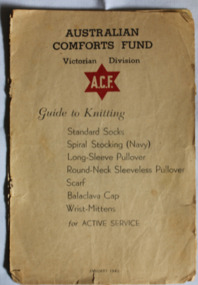
Booklet - Small booklet, Australian Comforts Fund Guide to Knitting, January 1940
Issued during WW2 for women to knit items of clothing for men on Active ServiceProvided comfort for men on Active Service in inhospitable areasRectangular tan coloured 12 page booklet. Has a RED six pointed star on the cover with A.C.F printed inside it.Page 8 has the #7 crossed out and substituted with #6. Page 12 has a three inch rule added in pencil.knitting, clothing -
 Federation University Art Collection
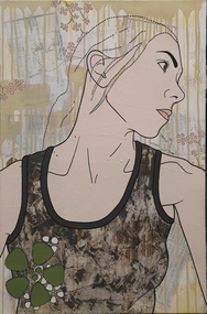
Mixed media, Simone Maynard, Looking East, 2006
Simone MAYNARD (1974- ) Melbourne based contemporary artist SIMONE Maynard is primarily influenced by the 1980s, reflecting a period of increasing global capitalisation, political upheaval, world-wide mass media, wealth discrepancies and distinctive music and fashion characterised by hip hop and electric pop music.Portrait of a womanVerso: Looking East 40x3 20060 inches; acrylic, ink & collage, hand stitching on canvas. SIMONE MAYNARD DEC 2006available, portrait -
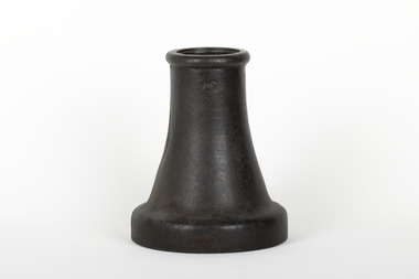
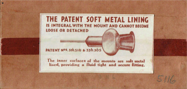 Geoffrey Kaye Museum of Anaesthetic History
Tool - Needle, John Bell & Croyden (Arnold & Sons)
Brown cardboard box with sliding insert containing hypodermic needles. On the front of the box is a buff coloured manufacturer's label with rust coloured print. On the rear of the box is a white coloured manufacturer's label with rust coloured print. The box has a thin strip of rust coloured plastic all the way around it. The insert has allocation for six needles but there are only four present.Stamped in black ink on front of box: EXPLORING / 19 B.W.G. 3 INCH •Stamped into metal at flat of connector: ARNOLD / SShypodermic, needle, syringe, john bell & croydon, arnold & sons -
 Clunes Museum
Plan, CLUNES WATER SUPPLY
DRAWINGS MADE TO SET UP A PERMENT PIPED WATER SUPPLY TO NEW NORTH MINE, CLUNES, VICTORIA, AUSTRALIA1 PAGE PLAN WITH DRAWING OF CLUNES WATER SUPPLY ON WAXED PAPER USING RED, BLACK AND BLUE INKCLUNES WATER SUPPLY LONGITUDINAL SECTION OF CENTRE LINE OF THE LOWER AWUEDECT FROM WEIR A TO SERVICE RESERVOIR DRAWING 420 5 CONTRACT NO. 740 2 HORIZONTAL SCALE FOUR CHAINS TO AN INCH VERTICAL SCALE FORTY FEED TO AN INCH SIGNED BY OCTAVIUS LANGTREE WORKS ENGINEER 13/12/1870octavius langtree, peter lalor, clunes water supply -
 The Beechworth Burke Museum
Functional object - Sluicing Nozzle, c1900
Nozzle was fitted in the end of the director and was used for hydraulic gold miningMining played an important role in the history of Beechworth, for the township was established in the mid-1850s after gold was discovered in the area. The success of goldmining lead to the growth and development of early Beechworth.A sluicing nozzle attachment which is 3 inch diameter inside top. Base area has thread machined inside for attachment to sluice. Casting venturi shaped internally.3 /burke museum, beechworth, gold mining, sluicing -
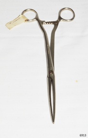 Flagstaff Hill Maritime Museum and Village
Surgical Instrument, early 20th century
This histerectomony forceps were used during abdominal operations. It was donated to Flagstaff Hill Maritime Village by the family of Doctor William Roy Angus, Surgeon and Oculist. It is part of the “W.R. Angus Collection” that includes historical medical equipment, surgical instruments and material once belonging to Dr Edward Ryan and Dr Thomas Francis Ryan, (both of Nhill, Victoria) as well as Dr Angus’ own belongings. The Collection’s history spans the medical practices of the two Doctors Ryan, from 1885-1926 plus that of Dr Angus, up until 1969. ABOUT THE “W.R.ANGUS COLLECTION” Doctor William Roy Angus M.B., B.S., Adel., 1923, F.R.C.S. Edin.,1928 (also known as Dr Roy Angus) was born in Murrumbeena, Victoria in 1901 and lived until 1970. He qualified as a doctor in 1923 at University of Adelaide, was Resident Medical Officer at the Royal Adelaide Hospital in 1924 and for a period was house surgeon to Sir (then Mr.) Henry Simpson Newland. Dr Angus was briefly an Assistant to Dr Riddell of Kapunda, then commenced private practice at Curramulka, Yorke Peninsula, SA, where he was physician, surgeon and chemist. In 1926, he was appointed as new Medical Assistant to Dr Thomas Francis Ryan (T.F. Ryan, or Tom), in Nhill, Victoria, where his experiences included radiology and pharmacy. In 1927 he was Acting House Surgeon in Dr Tom Ryan’s absence. Dr Angus had become engaged to Gladys Forsyth and they decided he further his studies overseas in the UK in 1927. He studied at London University College Hospital and at Edinburgh Royal Infirmary and in 1928, was awarded FRCS (Fellow from the Royal College of Surgeons), Edinburgh. He worked his passage back to Australia as a Ship’s Surgeon on the on the Australian Commonwealth Line’s T.S.S. Largs Bay. Dr Angus married Gladys in 1929, in Ballarat. (They went on to have one son (Graham 1932, born in SA) and two daughters (Helen (died 12/07/1996) and Berenice (Berry), both born at Mira, Nhill ) According to Berry, her mother Gladys made a lot of their clothes. She was very talented and did some lovely embroidery including lingerie for her trousseau and beautifully handmade baby clothes. Dr Angus was a ‘flying doctor’ for the A.I.M. (Australian Inland Ministry) Aerial Medical Service in 1928 . Its first station was in the remote town of Oodnadatta, where Dr Angus was stationed. He was locum tenens there on North-South Railway at 21 Mile Camp. He took up this ‘flying doctor’ position in response to a call from Dr John Flynn; the organisation was later known as the Flying Doctor Service, then the Royal Flying Doctor Service. A lot of his work during this time involved dental surgery also. Between 1928-1932 he was surgeon at the Curramulka Hospital, Yorke Peninsula, South Australia. In 1933 Dr Angus returned to Nhill and purchased a share of the Nelson Street practice and Mira hospital (a 2 bed ward at the Nelson Street Practice) from Dr Les Middleton one of the Middleton Brothers, the current owners of what previously once Dr Tom Ryan’s practice. Dr Tom and his brother had worked as surgeons included eye surgery. Dr Tom Ryan performed many of his operations in the Mira private hospital on his premises. He had been House Surgeon at the Nhill Hospital 1902-1926. Dr Tom Ryan had one of the only two pieces of radiology equipment in Victoria during his practicing years – The Royal Melbourne Hospital had the other one. Over the years Dr Tom Ryan had gradually set up what was effectively a training school for country general-practitioner-surgeons. Each patient was carefully examined, including using the X-ray machine, and any surgery was discussed and planned with Dr Ryan’s assistants several days in advance. Dr Angus gained experience in using the X-ray machine there during his time as assistant to Dr Ryan. When Dr Angus bought into the Nelson Street premises in Nhill he was also appointed as the Nhill Hospital’s Honorary House Surgeon 1933-1938. His practitioner’s plate from his Nhill surgery is now mounted on the doorway to the Port Medical Office at Flagstaff Hill Maritime Village, Warrnambool. When Dr Angus took up practice in the Dr Edward and Dr Tom Ryan’s old premises he obtained their extensive collection of historical medical equipment and materials spanning 1884-1926. A large part of this collection is now on display at the Port Medical Office at Flagstaff Hill Maritime Village in Warrnambool. In 1939 Dr Angus and his family moved to Warrnambool where he purchased “Birchwood,” the 1852 home and medical practice of Dr John Hunter Henderson, at 214 Koroit Street. (This property was sold in1965 to the State Government and is now the site of the Warrnambool Police Station. and an ALDI sore is on the land that was once their tennis court). The Angus family was able to afford gardeners, cooks and maids; their home was a popular place for visiting dignitaries to stay whilst visiting Warrnambool. Dr Angus had his own silk worm farm at home in a Mulberry tree. His young daughter used his centrifuge for spinning the silk. Dr Angus was appointed on a part-time basis as Port Medical Officer (Health Officer) in Warrnambool and held this position until the 1940’s when the government no longer required the service of a Port Medical Officer in Warrnambool; he was thus Warrnambool’s last serving Port Medical Officer. (Masters of immigrant ships arriving in port reported incidents of diseases, illness and death and the Port Medical Officer made a decision on whether the ship required Quarantine and for how long, in this way preventing contagious illness from spreading from new immigrants to the residents already in the colony.) Dr Angus was a member of the Australian Medical Association, for 35 years and surgeon at the Warrnambool Base Hospital 1939-1942, He served with the Australian Department of Defence as a Surgeon Captain during WWII 1942-45, in Ballarat, Victoria, and in Bonegilla, N.S.W., completing his service just before the end of the war due to suffering from a heart attack. During his convalescence he carved an intricate and ‘most artistic’ chess set from the material that dentures were made from. He then studied ophthalmology at the Royal Melbourne Eye and Ear Hospital and created cosmetically superior artificial eyes by pioneering using the intrascleral cartilage. Angus received accolades from the Ophthalmological Society of Australasia for this work. He returned to Warrnambool to commence practice as an ophthalmologist, pioneering in artificial eye improvements. He was Honorary Consultant Ophthalmologist to Warrnambool Base Hospital for 31 years. He made monthly visits to Portland as a visiting surgeon, to perform eye surgery. He represented the Victorian South-West subdivision of the Australian Medical Association as its secretary between 1949 and 1956 and as chairman from 1956 to 1958. In 1968 Dr Angus was elected member of Spain’s Barraquer Institute of Barcelona after his research work in Intrasclearal cartilage grafting, becoming one of the few Australian ophthalmologists to receive this honour, and in the following year presented his final paper on Living Intrasclearal Cartilage Implants at the Inaugural Meeting of the Australian College of Ophthalmologists in Melbourne In his personal life Dr Angus was a Presbyterian and treated Sunday as a Sabbath, a day of rest. He would visit 3 or 4 country patients on a Sunday, taking his children along ‘for the ride’ and to visit with him. Sunday evenings he would play the pianola and sing Scottish songs to his family. One of Dr Angus’ patients was Margaret MacKenzie, author of a book on local shipwrecks that she’d seen as an eye witness from the late 1880’s in Peterborough, Victoria. In the early 1950’s Dr Angus, painted a picture of a shipwreck for the cover jacket of Margaret’s book, Shipwrecks and More Shipwrecks. She was blind in later life and her daughter wrote the actual book for her. Dr Angus and his wife Gladys were very involved in Warrnambool’s society with a strong interest in civic affairs. He had an interest in people and the community They were both involved in the creation of Flagstaff Hill, including the layout of the gardens. After his death (28th March 1970) his family requested his practitioner’s plate, medical instruments and some personal belongings be displayed in the Port Medical Office surgery at Flagstaff Hill Maritime Village, and be called the “W. R. Angus Collection”. The W.R. Angus Collection is significant for still being located at the site it is connected with, Doctor Angus being the last Port Medical Officer in Warrnambool. The collection of medical instruments and other equipment is culturally significant, being an historical example of medicine, administration, household equipment and clothing from late 19th to mid-20th century. Dr Angus assisted Dr Tom Ryan, a pioneer in the use of X-rays and in ocular surgery. Surgical instrument, hysterectomony forceps, part of the W.R. Angus Collection. Stainless steel forceps, 8 inch (20cm). Paper tag attached. Made by Down Bros. of London.Impressed "DOWN BROS. LONDON"flagstaff hill, warrnambool, shipwrecked coast, flagstaff hill maritime museum, maritime museum, shipwreck coast, flagstaff hill maritime village, great ocean road, dr w r angus, dr ryan, surgical instrument, t.s.s. largs bay, warrnambool base hospital, nhill base hospital, mira hospital, flying doctor, medical treatment, hysterectomony forceps, abdominal forceps, surgical instrument -
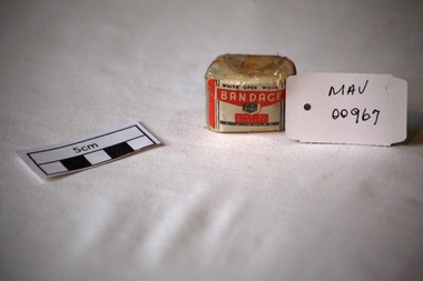 City of Moorabbin Historical Society (Operating the Box Cottage Museum)
Bandage, cotton, mid 20thC
A bandage is a piece of material used either to support a medical device such as a dressing or splint, or on its own to provide support to the body; it can also be used to restrict a part of the body. G. J. Coles opened the 'Coles Variety Store' on 9 April 1914 on Smith Street in the Melbourne, Victoria suburb of Collingwood. Further expansion occurred and Coles' interest in food retailing was spurred in 1958 when it acquired 54 John Connell Dickins grocery stores. It then acquired the Beilby's chain in South Australia in 1959 and 265 Matthews Thompson grocery stores in New South Wales in 1960 .In 1960, the first supermarket was opened in the Melbourne suburb Balwyn North, at the corner of Burke and Doncaster Roads where a modernised version continues to operate. By 1973, Coles had established stores in all Australian capital cities. From 1962, its supermarkets were branded Coles New World with accompanying rocket imagery. In 1991, the stores were re-branded Coles Supermarkets and from 1998, simply as Coles. George James (G. J.) Coles learned the retail trade working for his father's 'Coles Store' business from 1910 to 1913. The store continued operating as "The Original Coles" at Wilmot, Tasmania until it was destroyed by a fire on 24 January 2014. An unused, 1 inch ( 2.5cm ) x 6 yards ( 2metres) cotton, ‘open wove’ bandage in a cellophane wrapper sold by G.J. Coles Pty Ltd Variety StoresCellophane wrapper top: WHITE OPEN WOVE / BANDAGE / 1 X 6 YDS. / SPECIAL QUALITY / G.J.COLES * pharmacy, medicines, bandages, wounds, early settlers, market gardeners, moorabbin, bentleigh, cheltenham, cotton, gauze, coles g j pty ltd., variety stores, supermarkets, smith street collingwood, retailers, shops -
 Eltham District Historical Society Inc
Photograph, Queenstown State School, c.1905
Reproduced on p34 of 'Pioneers & Painters'This photo forms part of a collection of photographs gathered by the Shire of Eltham for their centenary project book,"Pioneers and Painters: 100 years of the Shire of Eltham" by Alan Marshall (1971). The collection of over 500 images is held in partnership between Eltham District Historical Society and Yarra Plenty Regional Library (Eltham Library) and is now formally known as the 'The Shire of Eltham Pioneers Photograph Collection.' It is significant in being the first community sourced collection representing the places and people of the Shire's first one hundred years.Digital image 4 x 5 inch B&W Neg Prints B&W 20 x 25 cm (2) and 9 x 12.5 cmsepp, shire of eltham pioneers photograph collection, queenstown, queenstown state school, pioneers and painters, school, st. andrews -
 Kiewa Valley Historical Society
Miners' Pick Axe Head
Miners used pickaxes to break up rock and ore, making it easier to extract valuable minerals. The pointed end of the pickaxe was used to chip away at rock. The flat end was used to strike the rock for breaking it apart.Used in the Kiewa Valley by miners searching for gold.Cast steel 14 inches long with a sharp pointed end and a small flat end. There is a space for the handle which is missing and may have been made from wood.mining, miners' pick axe -
 Flagstaff Hill Maritime Museum and Village
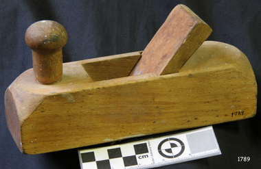
Tool - Smoothing Plane, Johann Heinrich August Bleckmann, 1870 to 1920
Johann Elias Bleckmann (1784-1856) founded a steel goods shop in Ronsdorf near Düsseldorf Germany. After completing a business education in his father's business, his son Johann Heinrich August Bleckmann (1826-1891) gained further experience through travel in North and South America. When his father died, he took over the steel goods store and moved it to Solingen. He bought a hammer mill in Mürzzuschlag Styria (Austria) in 1862 and converted it into a modern crucible casting steel smelter. His "Phoenix Steel", which he produced himself, achieved worldwide renown. He then went on to establish a file and tool factory and later founded a steel and plate rolling mill. Apart from cutlery blades, the company's self-produced steel was also processed into tools, scythes, rifle parts, etc. His sons Eugen and Walter continued after his death in 1891 at the Phoenix steelworks. However, by the end of the First World War, the two brothers fell into economic difficulties as a result of eliminating a large part of their foreign trade. In 1921, the company was converted into a public limited company and merged three years later with the company Schoeller & Stahlwerke. Made by Johann Heinrich August Bleckmann a significant Austrian manufacture of cutlery and tools in a recognized area of Germany famous for the production of steel items. The item is giving a snapshot of early colonial and European trades persons tools and gives an interesting insight into the development and progression of European tool and steel development and innervation prior to and just after the First World War.Plane Smoothing type with flat base. Has wooden wedge and iron missing. Knob handle is set on top and at the front. Iron 1 3/5 inches wide. Marked "Bleckmann (symbol) Safingen" "GN".flagstaff hill, warrnambool, shipwrecked-coast, flagstaff-hill, flagstaff-hill-maritime-museum, maritime-museum, shipwreck-coast, flagstaff-hill-maritime-village, plane -
 Federation University Historical Collection
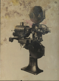
Image, Projector associated with Gem Pictures, c1930, c1930
Scan of a film projector associated with Gem Pictures, and pages of a catalogue that includes the Hahn-Goerz Theatre Projector with 8 inch standard "Artisol" Mirror lamp on column stand. theatre, film, entertainment, gem, rash, gem pictures, edwin rash, projector, film projector, hahn-goerz theatre projector, australasian films ltd -
Bendigo Historical Society Inc.
Map - PLAN NEW CHUM LINE OF REEF
Plan showing outcrops of reefs on supposed extension south of the New Chum line of reef from the Eureka extended company's ground. Scale 8 chains to 1 inchplan, bendigo, new chum line of reef -
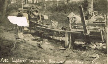 Bendigo Historical Society Inc.
Postcard - ACC LOCK COLLECTION: CAPTURED GERMAN 8IN HOWITZER NEAR BRAY, POSTCARD, 1914-1918
Postcard, WW1, B&W image of a captured German 8 inch Howitzer gun on the right. Another unidentified gun (?) at left. Located in a wooded depression. Copy A 42postcard, postcard, ww1, france, bray, german howitzer -
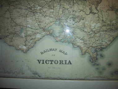 Parks Victoria - Mount Buffalo Chalet
Map, "Railway Map of Victoria"
Large framed map of Victoria, showing Victorias extensive rail network. Printed by Victorian Railways and is one of a number of 'framed pictures, particularly photographs of scenery, which have always been a feature of the Chalet.' (Pg 83. Historica, 2011) This map has been a permanent fixture situated in the hallway alongside the ballroom leading to the ski hire area since the 1950's and most likely earlier. Listed in Draft Inventory of Significant Collection ItemsLarge railway map of Victoria, Melbourne & Ballarat framed in white painted wood. Scale eight miles to one inch. Areas of the map have been whited out.Yes -
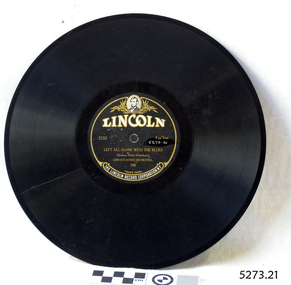 Flagstaff Hill Maritime Museum and Village
Audio - Gramophone Record
Bakelite record by The Lincoln Record Corporation N.Y. 2153 "Left All Alone With The Blues" by Lincoln Dance Orchestra No 700 Record cracked. Size: 10 inch recordflagstaff hill, warrnambool, shipwrecked-coast, flagstaff-hill, flagstaff-hill-maritime-museum, maritime-museum, shipwreck-coast, flagstaff-hill-maritime-village -
 Bendigo Historical Society Inc.
Map - PLAN OF BENDIGO CREEK, 12th March 1873
Map: Hand drafted plan of the Bendigo Creek, covering from Scott St. White Hills to Alder St. Kangaroo Flat. Scale 2 chains to 1 inchGeorge R------- ? City Surveyormap, bendigo, bendigo creek -
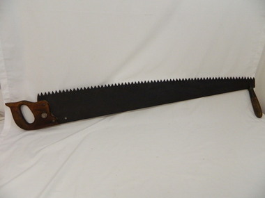 Kiewa Valley Historical Society
Saw Logging, circa early 1900's
This item can be seen as a hand piece belonging to a logger or farmer spanning over one hundred or more years. The equipment was made to perfection as a hand tool and has not been improved upon since its introduction into the logging industry or farming fraternity. It can be used by one person or two (husband and wife or father and child). Its versatility is ageless. It can be used for domestic clearing of the paddocks, or for domestic fire places and stoves or commercial logging up until the 2000s (introduction of specific logging trucks that cut and treat the trees in one process).This item is very significant to the rural and logging regions within the Kiewa Valley. It has been used for domestic wood cutting and for industrial logging in the mid to late 1900s. It was used when clearing land for the SEC Hydro scheme and to allow for the introduction of the Mount Beauty construction workers' village (later developed into the town) The great advantage of this saw was that it uses only muscle power and can be located where ever a lumber "Jack" or property owner can venture. either by foot or by horse.This saw is a Warranted Superior One/Two Man Logging Saw. It has 68 teeth and is 42 inches long. At a position of one inch (2.5cm) from the end is a hole one inch down from the leading edge. There is another hole 45 cm in front of the handle. Both these holes are for a "helper handle" which when in use renders this logging saw fit for a two man operation. This is a cross cut saw for cutting down vertical trees (horizontal cut) The handle is made from wood and fastened to the blade by three heavy duty screws. The one helper handle stands 150mm high and has a 150mm wooden hand grip.The central screw has 25mm manufacturers' identification logo stamped "WARRANTED SUPERIOR".one or two man cross cut saws, forestry, timber industry -
4th/19th Prince of Wales's Light Horse Regiment Unit History Room
Medal, Elizabeth II Coronation 1953
The Queen Elizabeth II Coronation Medal was a commemorative medal made to celebrate the coronation of Queen Elizabeth II. For Coronation and Jubilee medals, the practice up until 1977 was that the authorities in the United Kingdom decided on a total number to be produced, then allocated a proportion to each of the Commonwealth countries and Crown dependencies and other possessions of the Crown. The award of the medals was then at the discretion of the government of each territory, which was left free to decide who got a medal and why. A total of 138,214 medals were issued, including: 11,561 to Australians 12,500 to Canadians Ladies awarded the medal can wear it on their left shoulder with the ribbon tied in the form of a bow. The medals were issued without inscription except for the 37 issued to the British Mount Everest Expedition. These were engraved MOUNT EVEREST EXPEDITION on the rim.Miniature medal with ribbon. The full size medal is a circular, silver medal, 1.25 inches in diameter. The obverse features a crowned effigy of Queen Elizabeth II, in a high-collared ermine cloak and wearing the collar of the Garter and Badge of the Bath, and facing right. There is no raised rim and no legend. The reverse shows the Royal Cypher EIIR surmounted by a large crown. The legend around the edge reads QUEEN ELIZABETH II CROWNED 2nd JUNE 1953. The dark red ribbon is 1.25 inches (32 mm) wide, with two narrow dark blue stripes (0.09375 inches {3/32"} wide) in the centre (0.0625" apart) and narrow white stripes (0.0625") at each edge. medal elizabeth coronation -
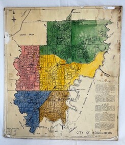 Greensborough Historical Society
Poster - Map, City of Heidelberg, 1965c
Map of the City of Heidelberg showing municipal boundaries and Wards are coloured. Scale 20 chains to 1 inch.An example of hard copy plans from the 1960s. Mainly from the Shire of Diamond Valley era (1964-1994).Colour map, pasted on card and laminated.Stamped and handwritten Council permissions, dates and other details. city of heidelberg, heidelberg - maps, local government -
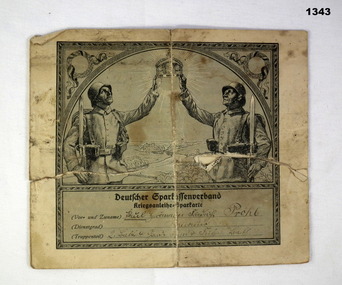 Bendigo Military Museum
Currency - GERMAN WAR BOND, 1914-17
The item was most likely to have been brought home by James Todd No 2418, 12th Batt AIF. Refer Cat No 1340P.German war bond, grey and black print, folds in half. Front has two German soldiers holding up a crown, underneath is owner's details, surname "Prohl". Inside is more details and stamps, 1917 mentioned. Handwriting on rear.Written in pencil: "The owner of this bond - got(?) a few inches of dirt over him at a place called Wineecourt Village 10/8/18"documents-certificates, financial, war bonds, german -
![Planning Document, Plan of proposed subdivision of land in Greensborough [Map shows Scotland house], 01/04/1971](/media/collectors/4f729f5697f83e03086015b8/items/5982a68921ea6b1420e4e560/item-media/59916fb521ea681094908d7a/item-fit-380x285.jpg) Greensborough Historical Society
Greensborough Historical SocietyPlanning Document, Plan of proposed subdivision of land in Greensborough [Map shows Scotland house], 01/04/1971
This subdivision of Greensborough shows the home of John Scotland (died 1888) and surrounding area bounded by Hailes, William, Lorimer, and Jessop Streets.Photocopy of plan, 2 pages.Part of plan (68G) of proposed subdivision of Greensborough, part of Crown Portion 18, Parish pf Keelbundora. Scale: 132 ft. to an inchjohn scotland, hailes street greensborough, william street greensborough, lorimer street greensborough, jessop street greensborough -
Emerald Museum & Nobelius Heritage Park
Fowlers Vacola bottling outfit, Circa 1915
This item was used in the 20th century to preserve cooked food. Fruit and VegetablesShowing how everything was home made years ago.Large metal round pot for preserving fruit and vegetables. Also includes various size jars with corresponding lids and clips.On top of metal lids is Fowlers Vacola Reg. No. 28195 with corresponding lid size in inches. Glass jars are embossed with the words Fowlers Vacola preserving -
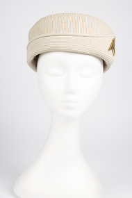 Sir Reginald Ansett Transport Museum
Headwear - Hat, Pillbox, 1969-1972
Part of hostess/stewardess uniform designed for Ansett Airlines of Australia 1969 to 1972. Donated to Sir Reginald Ansett Transport Museum. Complements the collection of air flight crew attire 1969 to 1972.Beige pillbox hat, with a flat crown and straight, upright sides.Turned brim, featuring peaked detail on one side. Piped edging. Heavy duty cotton fabric with reinforcing stitches. Fawn grosgrain ribbon interfacing inside. Cream Bem silk lining. Gold coloured badge features 1968-1981 Ansett logo: A Delta"Nivek Headware Reg. Melb" on label inside. Blue ink numeral 21 handwritten on label. Possibly size 21 inch hat.hostess, 1970's, flight attendants, ansett airlines of australia, stewardess, pillbox, 1969-1972, beige, nivek headwear