Showing 10969 items
matching maps
-
 Kew Historical Society Inc
Book, Colin Jones, Ferries on the Yarra, 1981
Collingwood, Vic. : Greenhouse, 1981 108 pages : ill., map ; 26 cm. non-fictionferry services -- ferries -- melbourne -- yarra river, ferries -- victoria =- yarra river -- history, ferries -- victoria -- melbourne -- history. -
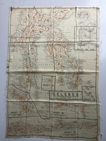 B-24 Liberator Memorial Restoration Australia Inc
Australian World War II silk map of Celebes, 1940s
Silk and rayon maps were produced by Australia, Great Britain (some 1.75 million in total) and the United States (c.7.5 million) during World War II. They were issued to Allied military personnel as part of 'escape and evasion' kits.This silk map, one of relatively few produced in Australia (most Australian RAAF pilots and crew were issued with British and US maps), is an original map from World War II.An oblong, cream colour, single-sided map printed in black and white with brown contours, Celebes 'Prepared under the direction of RAAF Headquarters' Celebes (with Insets 'A' to 'E')world war ii, silk maps, australia, a185 -
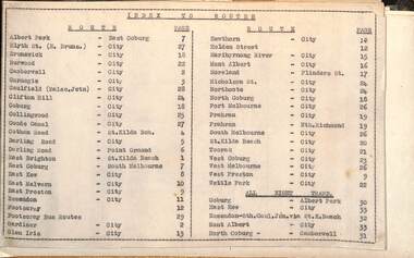 Melbourne Tram Museum
Administrative record - Tram fare route diagrams or maps, Melbourne & Metropolitan Tramways Board (MMTB), 1930s
... maps ...The route maps give for each tram, including cable trams, and bus routes, a map of the fare structure, sections, all-night routes, details of transfers and tickets such as combined tickets. Not dated as such but sheet 1 has a note regarding the East Brighton - St Kilda route that it was out of date from 16/10/1938.Yields information about the MMTB fare structure for tram, and bus routes during the 1930s.Album brown card heavy card coves, secured with two interscrews containing a type index, 33 cartridge paper sheets with ink drawings and six loose sheets. Hand drawn in black, red and green ink.mmtb, tramways, fares, maps, routes, buses, cable trams -
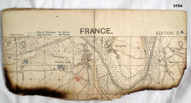 Bendigo Military Museum
Map - TRENCH MAP WW1, 1918
Areas covered on this map, “Hamel, Mericourt, Proyart, Weincourt, Harbonnieres”. Item re William Alexander No 502 AIF. Refer Cat No 3746.3 for his service details.Trench map, France, Edition 2A, sheet 62D S.E, scale 1:20,000, trenches corrected to 22.4.1918, trenches in red. On outside in blue handwriting “62D S.E”map, trench, france -
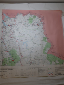 Kiewa Valley Historical Society
Map - Road Construction Authority 1986, Ref. Tallangatta 282008
Government authorities updated maps regularly.Historically of interest eg. 1. Pre dates the Alpine National Park. 2. 'Mt Beauty Estates' now known as Tawonga South. 3. Mt Niggerhead is named - It is now known as Mt Jaithmathang having been renamed in 2009.Colored map dated 1986 titled Road Construction Authority with an update of roads in the local Shires. It names places in the area and has a legion describing the rating of the roads and tracks. It also shows the main towns in the area and their roads.road construction authority, map of tallangatta area -
 Victorian Aboriginal Corporation for Languages
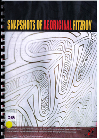
Book, Bunj Consultants, Snapshots of Aboriginal Fitzroy, 2004
Features artwork by VACL Project Officer Mandy Nicholson.maps, photographswurundjeri, carlton gardens, alexandria gardens, maysar, batman treaty, oral histories -
Victorian Aboriginal Corporation for Languages
Conference proceedings, Marleen Haboud, Endangered languages : voices and images, 2011
Linguistic and Sociolinguistic properties; sociolinguistics and endangered languages; Rights, identities and new technologies; New media cultures and endangered languages; Rebuilding peoples in Ecuador and revitalizing their languages Documentation - successful experience; Language rights of endangered languagesMaps, graphslanguage endangerment, worrorra, language technologies, documentation -
 Victorian Aboriginal Corporation for Languages
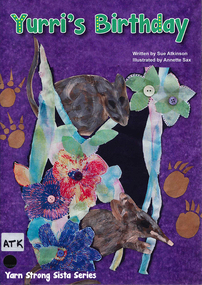
Book, Sue Atkinson, Yurri's birthday, 2013
Tonight would be a very special night for Yurri, it is her birthday. At midnight each of Yurri's friends arrive with a basket. Inside each basket is a gift for Yurri. Each illustrated basket has been made by women who live in Victoria and are passionate about the revival of basket coiling! Yurri's Birthday written by Sue Atkinson (Yorta Yorta) and illustrated by Annette Sax (Taungurung). This is the third book in the YSS series, giving young children insight into Indigenous Victorian culture. The Yarn Strong Sista series is supported by background notes and ideas for related activities.Illustrations, mapsyorta yorta, barmah forest, basket weaving, educational activities, language list -
 Victorian Aboriginal Corporation for Languages
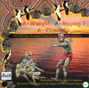
Book, Palibu Patrick Nudjulu, A-wanybi, A-muying i A-vilimindji = the mud crab, the magpie goose and the pied cormorant: ancestral knowledge of the Magati Ke Rak Naninh people, 2006
Story in Language and English with illustrationsillustrations, mapsmagati ke rak naninh people, storytelling, animals -
 Victorian Aboriginal Corporation for Languages
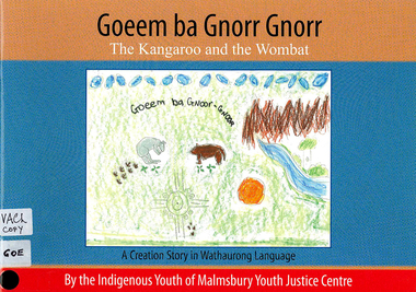
Book, Indigenous Youth of Malmsbury Youth Justice Centre, Goeem ba Gnorr Gnorr : the Kangaroo and the Wombat : a Creation story in Wathaurong Language, 2009
Creation story with word listmaps, illustrationswathaurong, yorta yorta, storytelling, word list -
 Victorian Aboriginal Corporation for Languages
Book, Barry J Blake, Case marking in Australian languages, 1977
Linguistic study using case markings. Glossary.Maps, tableslinguistics, case relations in languages, pama-nyungan languages -
 Victorian Aboriginal Corporation for Languages
Book, Annette Schmidt, The loss of Australia?s Aboriginal Language heritage, 1993
Overviews Aboriginal language situation; examines attitudes to language; analyses language maintenance and revival programs, bilingual education, effectiveness of funding and National Aboriginal Languages Program; availability of linguistic training, characteristics of language loss and the place of creoles in language programs.Maps, chartslanguage loss, language maintenance, reports -
 Victorian Aboriginal Corporation for Languages
Book, Julie Bishop, Aboriginal students and English language acquisition, 1993
Assisting educators in South Australia to respond to specific language and literacy needs and goals of Aboriginal students.maps, tablesnepabunna, raukkan, coober pedy, education, resource-based learning, literacy, carlton primary school, english language acquisition -
 Victorian Aboriginal Corporation for Languages
Book, Christine Walton, Language : maintenance, power and education in Australian Aboriginal contexts, 1990
Conference themes of language and power, language maintenance and language in education raised in an Aboriginal context; papers separately annotated.maps, tablesyolngu, yirrkala school, language maintenance, bilingualism, vernacular language -
 Victorian Aboriginal Corporation for Languages
Book, Tonya Stebbins, Fighting language endangerment : community directed research on Sm'algyax (Coast Tsimshian), 2003
Based on studies of the language of the Tsimshian people, who live on the northwest coast of British Colombia, Canada. It describes the peocess of community directed documentation for an endangered language based on the dictionary project.Maps, tableslanguage endangerment, tsimshian -
 Victorian Aboriginal Corporation for Languages
Book, Aboriginal and Torres Strait Islander Commission Broadcasting, Languages, Arts and Culture Section, Needs survey of community languages 1996, 1996
The survey aims to document the Indigenous language situation and to establish the extent of Indigenous language needs so as to provide a sound basis for further program planning.maps, surveyeducation policy, language policy -
 Victorian Aboriginal Corporation for Languages
Book, Implementation Review Team on behalf of the Victorian Aboriginal Justice Forum, Victorian implementation review of the recommendations from the Royal Commission into Aboriginal Deaths in Custody : review report, 2005
maps, tablesaboriginal deaths in custody, criminal justice system -
 Victorian Aboriginal Corporation for Languages
Book, Board of Studies NSW, Aboriginal languages : advice on programming and assessment for stages 4 and 5, 2003
Includes Advice on Planning and Assessment, Samples on each stage, Sample Units of Work, useful Resources.maps, tableseducation, curriculum development -
 Victorian Aboriginal Corporation for Languages
Book, Victorian Curriculum and Assessment Authority, Aboriginal languages, cultures and reclamation in Victorian schools : standards P-10 and protocols, 2009
maps, diagramseducation, language revival, bilingual education -
 Victorian Aboriginal Corporation for Languages
Book, Australian Indigenous Languages Framework Project, Australian Indigenous languages framework support materials, 1994
maps, tableskaurna, education, bilingual education, lote, languages other than english, language revival, aboriginal english, language ecology -
Whitehorse Historical Society Inc.
Document, F. S. Baker/ Yarra Hill country map, 1950s
Advertising leaflet for F. S. Baker, Mt. Pleasant Road Nunawading,Advertising leaflet for F. S. Baker, Mt. Pleasant Road Nunawading, Real Estate Agent c. 1950s, backed by Broadbent's Map no. 280, Yarra Hill CountryAdvertising leaflet for F. S. Baker, Mt. Pleasant Road Nunawading, broadbents, baker, f. s., mount pleasant road, nunawading, no. 20 -
 Warrnambool and District Historical Society Inc.
Map - Map of Proposed Alterations to Warrnambool Harbour 1925, Warrnambool Harbour Committee, Warrnambool Harbour Proposed Wharves and Basin in Lake Pertobe with Eastern Wall, 1925
This map was printed in 1925 and contains the Warrnambool Harbour alterations proposed by the Warrnambool Harbour Committee incorporating the original designs of Captain Menzies, the Warrnambool Harbour Master and the City Engineer, Mr A. Lavercombe. The main features of the proposal were the extension of the Eastern Wall to almost enclose the harbour and a basin in Lake Pertobe. The design was to be placed before the Victorian Royal Commission on the Outer Ports which was established partly to examine the allegations of unsatisfactory work carried out in Warrnambool when the Breakwater was extended 300 feet in 1914 and also to make recommendations regarding all regional ports. The Warrnambool Breakwater was completed in 1890 but failed to provide the shipping conditions needed to continue Warrnambool as a viable port. Many plans and proposals for port improvement such as this one were produced in the late 19th century and the first half of the 20th century with the port officially closed in the 1940s. Still today the Breakwater and Warrnambool Harbour conditions remain a source of contention.This map is significant as it shows a 1925 design for Warrnambool Harbour hitherto little-known. It also has markings showing land sites of the time (BayView Hotel, Woollen Mill etc.)This is a map made of thick yellow paper pasted onto a cloth backing. It has two cloth tags at the top for tying up the map when folded. It appears to be a hand-drawn map copied with printed material added. The map is shaded green and red in some areas. Attached by nails to the map are wooden frames, rounded at the bottom and partly curved at the top. The map is torn and partly detached at the top. The top frame has a cord attached for hanging the map.warrnambool harbour, captain menzies, a.lavercombe city engineer, warrnambool breakwater, royal commission on outer ports -
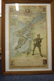 Wangaratta RSL Sub Branch
Framed Poster
Map of the Dardanelles Strait, Turkey, used as a World War I recruiting poster Includes photographs of King George V; Major-General Sir W.T. Bridges; Brigadier General G.D. Legge; General Sir Ian Hamilton; and Lieut-General Sir William Birdwood and list of Australian Commonwealth Brigade CommandersPosters were used for various government propaganda campaigns over the course of World War I, most significantly to encourage enlistment, but also to raise money for war charities, to encourage saving and frugality and to rally the home front.Timber framed poster of map of Dardanelle Peninsula featuring soldier holding rifleIn top margin: "Rally round the flag, boys!" In lower margin: "Your King and country needs you!" ww1, recruiting poster -
 Eltham District Historical Society Inc
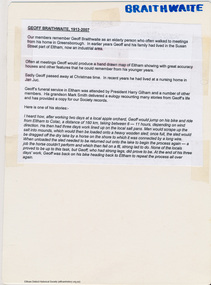
Map, Geoff Braithwaite, Braithwaite ma0p of Eltham circa 1920
A3 photocopy of hand drawn map of Eltham created by Geoff Braithwaite (1914-2008) of his memory of the township about 1920. It includes names of streets and property owners. Folder of information on Geoff Braithwaite Includes A3 photocopy of hand drawn map of Eltham with coloured shading of Eltham in 1920s and 1930sharry gilham collection, eltham, 1920, geoff braithwaite, map, smart family cottage, eltham cemetery, flora caroline braithwaite (nee gamble), geoffrey braithwaite -
 Bendigo Military Museum
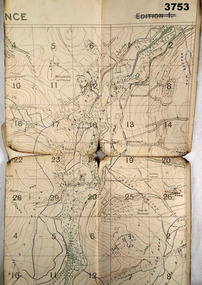
Map - TRENCH MAP WW1, 1918
Areas covered on this map, “Coisy, Allonville, Busy, Franvillers” Item re William Alexander No 502 AIF. Refer Cat No 3746.3 for his service details.Trench map, France, Edition 2A, sheet 62D N.W, scale 1:20,000, trenches corrected to 7.5.1918, British trenches in blue.On outside drawn in purple “62D N.W 1:20,000”map, france, trench -
 Clunes Museum
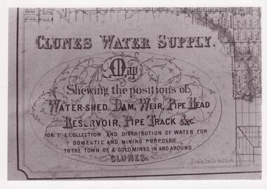
Photograph
CLUNES WATER SHED SUPPLY MAP SHEWING THE POSITION OF WATERSHED ECT. FOR THE COLLECTION AND DISTRIBUTION OF WATER FOR DOMESTIC AND MINING PURPOSES TO THE TOWN OF & GOLDMINES IN AND AROUND CLUNES.PHOTOCOPY SECTION OF PHOTOGRAPH AND PLAQUE AND MAP OF CLUNES WATER SUPPLY. SHOWING THE POSITION OF WATERSHED, DAM, WEIR PIPEHEAD RESERVOIR PIPE TRACK.SEE PHOTOGRAPH ON BACK OF HISTORY OF OBJECT.local history, photographs, water supply -
 Federation University Historical Collection
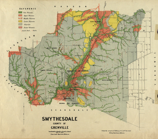
Map, Smythesdale, County of Grenville, 1888, 1889
The map maker, Ferdinand M. Krause, was a professor at the Ballarat School of Mines. This land was printed form the Crown Lands Department, Melbourne. Coloured map of the County of Grenville. The edge has been taped. The scale is 40 chains to 1 inch. The map is accompanied with a foolscap sheet printed by the Mines Department in 1898. It is a Report on the Parish of Smythesdale by F.M. Krause and includes information on the water reserve, worked quartz veins, Watson's Hill, Surface Hill and Sugarloaf Hill, Haddon, Trunk Lead and the Crucible Shaft. smythesdale, krause, f.m. krause, ferdinand krause, nitingbool, watson's hill, surface hill, sugarloaf hill, haddon -
 Whitehorse Historical Society Inc.
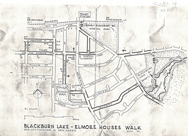
Map, Blackburn Lake - Elmore houses walk, 1/11/1991
... maps ...Map of Blackburn outlining a walk through the lake.Map of Blackburn outlining a walk through the lake. The route includes four Elmore houses.Map of Blackburn outlining a walk through the lake.maps, blackburn lake sanctuary, the avenue, blackburn, laburnum street, main street, gardenia street, blackburn road, gordon crescent -
 Whitehorse Historical Society Inc.
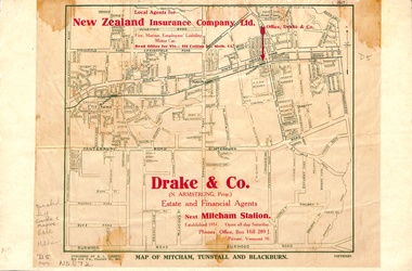
Map, Map of Mitcham, Tunstall and Blackburn, 1920 ?
... maps ...Map of Mitcham, Tunstall and Blackburn.Map of Mitcham., Tunstall and Blackburn. Overprinted 'Drake & Co.' 1 copy 1927?, 1 copy 193-?Map of Mitcham, Tunstall and Blackburn.mitcham, tunstall, nunawading, blackburn, maps, drake & co., forest hill, vermont -
 Lara RSL Sub Branch
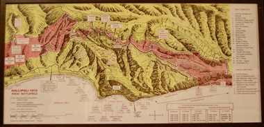
Photograph, Gallipoli Map Anzac Battlefield 1915
This map shows where the first battalions landed at Gallipoli (April 25) Position of ANZAC battalions when the Turks attacked across the whole front and lost 10,000 dead and wounded (19 May) ANZAC evacuation (20th Dec 1915)Detailed map showing historical sights and battlefields with an information listGallipoli Map Anzac battlefield 1915,Rectangular in shape glass covered picture frame with a wooden boarder.Gallipoli 1915 Anzac Battlefieldphotograph., gallipoli., 1915, anzac, world war one, ww1, battlefield