Showing 10751 items
matching plan
-
 Federation University Historical Collection
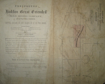
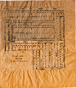
Plan and Prospectus, Plan and Prospectus of the Haddon Great Extended Gold Mining Company
The Haddon Great Extended GMC was formed sometime in the 1870s for the purpose of mining 270 acres of land lying to the south-west of the Racecourse Company (who at that stage had a shaft at the depth of 86 feet)A printed piece of paper with a prospectus on the left and a plan on the right. The plan includes a shaded area representing the Haddon Great GMC, and shows neighbouring companies such as Racecourse GMC, Haddon Consols, Reform GMC, Haddon Co, and also shows Russel's Private Propert and Roach's Private Company, and the Trap-Rock Formation.haddon great extended gmc, wc elder, william levey, c thorburn, john langdon, hb forster, national bank of australasia, haddon, racecourse company, h.b. forster, w.c. elder, john langdon, william levey, c. thorburn, john langdon, shares, racecourse goldmining company, reform gold mining company, haddon consols, haddon great extended gold mining company, russell -
 Ballarat Tramway Museum
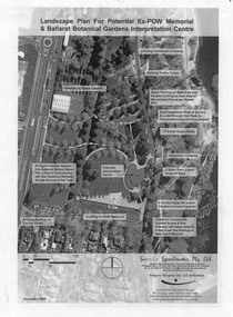
Document - Photocopy, Gregory Burgess Pty Ltd and Architects and, "Landscape Plan for Potential Ex-POW Memorial & Ballarat Botanical Gardens Interpretation Centre", Nov. 2005
Three page photocopy consultation document titled "Landscape Plan for Potential Ex-POW Memorial & Ballarat Botanical Gardens Interpretation Centre" showing concept plans for the development to the east of the tram depot and for the POW memorial. The project did not proceed. Prepared by Gregory Burgess Pty Ltd, Architects, November 2005.trams, tramways, gardens, depot, botanical gardens -
 Federation University Historical Collection
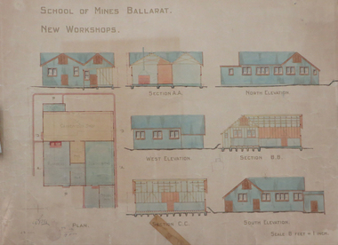
Plan, Ballarat School of Mines New Workshops, 1912, 08/1912
Original plan for new workshops for the Ballarat School of Mines. Includes elevations and sections, abd has been coloured with watercolour. The new workshops housed carpenters shop, plumbers, blacksmihing and stores. ballarat school of mines, new workshops, carpentry, blacksmithing, plumbing, architectural plan, laboratory -
 Glenelg Shire Council Cultural Collection
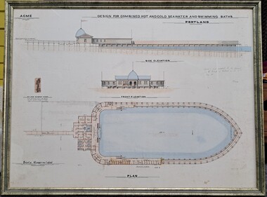
Drawing, ACME, Design for Combined Hot and Cold Seawater and Swimming Baths - Portland, c. 1888
Drawing/plan showing the design for the Portland Seabaths. At the top of the plans is the side elevation titled underneath, below is the front elevation and at the bottom the whole plan from the top. The scale is 16 feet to 1 inch. There is also an image of the Wilson Donkey Pump.Top Left - ACME Design for Combined Hot and Cold Seawater and Swimming Baths / Portland In handwriting to the right of the plan ' Agreed to and adopted by the Council of the Borough of Portland on the 30th May 1888'portland sea baths, seawater baths, acme, design, plan -
 Stawell Historical Society Inc
Archive, Stawell Gold Mine, Stawell Gold Mine Emergency Plan, 1/08/2015
Plans produced by Mine for Emergency use showing ventilation & Emergency Exits Plans and Conatacts.Ring Bound A3 book with laminated Covers & Black and Yellow Banding for attentionDate of Issue 31/ 08/2015 Uncontrolled Copymining, gold -
Melbourne Tram Museum
Newspaper, The Age, “Fears Caulfield to Rowville tram plan no longer on track”, 30/05/2019 12:00:00 AM
Newspaper clippings titled: “Fears Caulfield to Rowville tram plan no longer on track” Newspaper clipping from the Age 30/5/2019 by Timna Jacks Councils in Melbourne's south-east suburbs concerned that plans for new tram line linking Caulfield train station and Monash University's Clayton campus have been shelved due to no money allocated in the budget. Premier Daniel Andrews had promised the government would plan and design an 18 kilometre tram route from Caulfield to Rowville.trams, tramways, planning, caulfield, tram routes, new tramway -
 City of Moorabbin Historical Society (Operating the Box Cottage Museum)
Plan - Scott's Estate, Bentleigh
The train line from the city to Frankston was electrified in 1922 which intensified the sale in the municipality of Moorabbin, particularly land which was in the vicinity of the railway stations.Example of the progress of the Municipality of MoorabbinHand drawn plan of Scott's Estate, BentleighHand drawn plan of Scott's Estate, Bentleighcentre road, scotts street, renown street, lawaon street, wood street, leckie street, bolinda street, bentleigh, real estate -
 Federation University Historical Collection
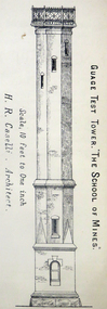
Architectural Plan, Ballarat School of Mines Gauge Tower Architectural Plan, c1883
The Ballarat School of Mines was the first of its type in Australia. The Albert Street frontage was the 'working end' of the campus with the mining laboratory, gauge tower and caretakers cottage. All the structures in the foreground have been demolished to make way for the Flecknoe Building and the M.B. John Building. Harry Brew, the well known Ballarat School of Mines caretaker, lived in the small weatherboard building to the right of the photograph. He was appointed to the staff at the Ballarat School of Mines in 1936.Printed copy of an architectural plan for the Ballarat School of Mines Gauge Tower as printed in the 1879 Ballarat School of Mines Annual Report.henry caselli, henry richards caselli, architectural plan, ballarat school of mines, gauge tower -
Port Melbourne Historical & Preservation Society
Document, "Plan of Town of Melbourne 1837 A.D.", 1937
Photocopy of "Plan of Town of Melbourne 1837 A.D." Also showing first land sales, historical memoranda, and an alphabetical list of purchases.town planning, town of melbourne -
Lakes Entrance Regional Historical Society (operating as Lakes Entrance History Centre & Museum)
Book, Context Pty Ltd, Draft Management Plan for Colquhoun Regional Park, 2000
Report on the heritage workshop held at Lakes Entrance on 1st.June 2000, when a draft Community Heritage Plan was developed to be presented to the Shire.heritage, history, settlement -
Whitehorse Historical Society Inc.
Article, Big Plan for Mitcham Centre, 1966
Big plans approved for the development of a parking area and supermarket.Big plans approved for the development of a parking area and supermarket - a milestone for an eight-year campaign by Mitcham Chamber for off-street parking.Big plans approved for the development of a parking area and supermarket.armstrong, raleigh, terry, w.g., mitcham chamber of commerce, education department, mitcham primary school no 2904 -
University of Melbourne, Burnley Campus Archives
Document - Memorandum, The University of Melbourne, Amendments - Conservation Management Plan, Burnley Campus, 19.10.2005
garden management, campus management, conservation -
 Camberwell Historical Society
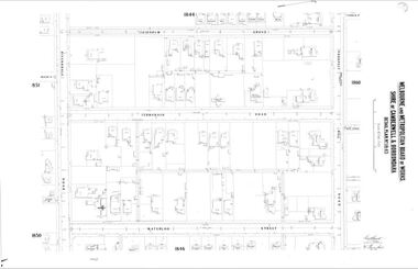
Map (Item) - MMBW map, Melbourne and Metropolitan Board of Works, Melbourne and Metropolitan Board of Works - Shire of Boroondara and Camberwell - Detail Plan no. 1845, August 1904
Lithographer JEM, exd. JWD, June 1904, no. 71. 40P.15W.melbourne and metropolitan board of works, map, camberwell, cartography -
 Federation University Historical Collection
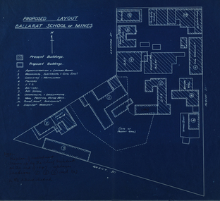
Plan, Ballarat School of Mines Proposed Layout
Blueline plans of the present and proposed layout the Ballarat School of Minesballarat school of mines, buildings, plans, grant street, lydiard street south -
Clunes Museum
Document - PLAN, JOHN RUTHERFORD, CLUNES KNITTING AND MANUFACTURING COMPANY
PLAN & GENERAL ARRANGEMENT FOR THE CLUNES KNITTING AND MANUFACTURING CO. LTD. local history, documnts, plans, knitting mill interknit hosiey co. -
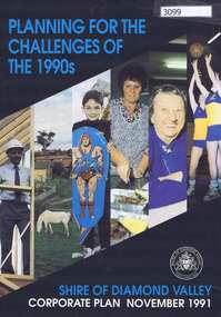 Greensborough Historical Society
Pamphlet, Planning for the challenges of the 1990s: Shire of Diamond Valley Corporate Plan, 1991_11
Shire of Diamond Valley Corporate Plan 1991. Includes Shire map and statistics with plans for services to the community.16p. text and coloured photographsshire of diamond valley -
![Map, Plan of Subdivision [Allotments along Lerderderg, George and McFarland Streets]](/media/collectors/5e461d8021ea67224c82f2a1/items/675d7243165f146b8adfc656/item-media/675d72d7165f146b8adfc859/item-fit-380x285.jpg) Bacchus Marsh & District Historical Society
Bacchus Marsh & District Historical SocietyMap, Plan of Subdivision [Allotments along Lerderderg, George and McFarland Streets]
This map shows allotments of land on the northern side of Lerderderg Street from Gisborne Road through to the approximate site of the present day Bacchus Marsh Primary School. There are also allotments shown on the southern side of McFarland Street between George Street and Gisborne Road. Larger allotments of land are shown extending northwards towards Masons Lane. Inscribed at the top of the map are the words, 'Plan of Subdivision of Cr Pors (Crown Portions) 12 & 13 & Allotments 1,2,3,4, Block 3, Parish of Korkuperrimul, County of Bourke'. The date of the map has not been established but the absence of the Bacchus Marsh Primary School on the map suggests it may have been produced prior to 1865 when the primary school was built in Lerderderg Street.Single page map showing house block size land allotments in the Lerderderg, George Street and McFarland Street area of Bacchus Marsh with larger allotments north of this area towards Masons Lane also shown. Scale 150 feet to 1 inch. Part of a set of maps which are pasted into a bound volume containing 76 maps or plans in total. High resolution digital image stored on BMDHS computer network. bacchus marsh victoria maps, lerderderg street land allotments, mcfarland street land allotments -
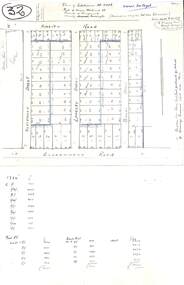 Ringwood and District Historical Society
Plan, Plan of Subdivision No.11498 with handwritten costing notations - East Ringwood Central Estate c.1948
Two handwritten pages showing layout of Subdivision no 11498 with surveyor notations including property sizes and road construction cost calculations. Drainage easement 6 feet wide shaded blue.Plan of Subdivision No. 11498, Part of Crown Allotment 27, Parish of Ringwood, County of Mornington, (Certificate of Title Vol 5120 Fol 1023945). Owner Mr Vogel. Subdivision includes Knaith Road, Northwood Street, Langley Street, Bondi Street, and Government Road (later Alexandra Road), Ringwood East. G. Parsons & Sons, Licensed Surveyors, 389 Flinders Lane (Melbourne). -
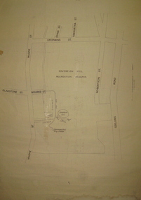 Federation University Historical Collection
Plan, Sovereign Hill Recreation Reserve and Surrounds
This map was probably produced around the time that the Sovereign Hill Museums Association was established. A simple plan with black marking on paper. It shows the Sovereign Hill Recreation Rerserve, including the swimming pool located near the Sovereign Hill Trig Point, showers, toilets, kiosk, bandstand and pine trees. The plan also depicts the Ballarat East streets surrounding Sovereign hill, including Geelong Road, Magpie Street, Stephens Street, Tregurtha Street, Dunn Street, Bourke Street, Gladstone Street and Robertson Street. The scale is 2 chains to 1 inch.sovereign hill, swimming pool -
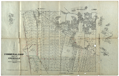 Federation University Historical Collection
Plan, Commeralghip, County of Grenville, 1905, 03/02/1905
The Township of Kaleno is in the Pitfield Plains. The Cape Clear Cemetery T contains the graves of miners and local pioneering families from the Cape Clear, Hollybush, Kaleno, Pitfield Plains, Pitfield, Illabarook, Berringa, Springdallah, Wallinduc, Glenfine, Happy Valley and Western Creek districts.Plan of allotments in Commeralghip, County of Grenville, Victoria. The plan includes the township of Kaleno, Dereel Pre-Emptice Right (John Cullen), Commeralghip Pre-Emptive Right (John Gordon McMillan and Glenfine Pre-Emptive Right (William Rowe). It also includes landholders such as Robert mcPherson, C. Cameron. John Boyd, John Cullen, W.T. Rowe, George Currie, J.P. Mackay, T. McCaffery, G. Hawkins, Alexander McPherson, C. Cameron. Gift of the Squire Family, 2014commeralghip, pitfield plains, kaleno, dereel, glenfine, squire, richard squire, w.t. rowe, john cullen, alexander mcpherson, george currie, mt misery, william rowe, mindai, john gordon mcmillan -
Federation University Historical Collection
Book, University of Ballarat - Daylesford: Product Development Plan
University of Ballarat - Daylesford: Product Development Plan JT701/Tourism Planning and Development Lecturer/Tutor: Mary HollickWhite soft covered book of 68 pages including 13 appendices.university of ballarat, daylesford, mary hollick, andrew cyples, todd edmonds, kylie harrington, nicole landers, jess lewis, hepburn shire council, introduction, methodology, history of daylesford, infrastructure audit, hepburn mineral springs & springs reserve, hepburn springs bath house, lake daylesford, the convent gallery, road access to daylesford, rail and coach access to daylesford, the lake house, wombat gardens & victoria park, jubillee lake, jim crow, wombat, sir charles hotham, warren hastings, central, tipperary and golden mineral springs, lavandula lavender farm, the macaroni factory, smeaton, guilford, trentham, maldon, creswick, castlemaine, clunes, dja dja wurrung, swiss/italian, mineral water, hepburn mineral springs reserve, jubilee lake, central springs, tipperary springs, golden springs -
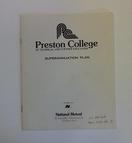 NMIT (Northern Melbourne Institute of TAFE)
Brochure - PCOT, Superannuation Plan, 1982
This brochure outlines a new superannuation plan for staff of Preston College of TAFE in 1982. The plan is in association with National Mutual.Signifies the changes to superannuation in the 1980s.7 page booklet with cream card coverpreston college of tafe, pcot, staff, superannuation, national mutual, nmit, -
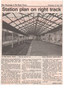 Melbourne Tram Museum
Newspaper, The Emerald Hill, Sandridge & St Kilda Times, "Station Plan on right track", 26/05/1993 12:00:00 AM
Newspaper clipping from The Emerald Hill, Sandridge & St Kilda Times, 26-5-1993 - titled "Station Plan on right track" about the then derelict former St Kilda Railway station. Reports on the history of the site, plans to refurbish by the Council, also look for uses for the site. Photo by Maurice Grant-Drew, story by Angela Izard.trams, tramways, st kilda railway station, railways -
Stawell Historical Society Inc
Map - Picture, Plan of Mining Leaseholders and of Land Applies for under Mining Lease November 1887. Plus photocopy, 1887
Lists Businesses in Stawell Trade Directory Mines Listed. New Darlington Mine, Moonlight Junction, Magdala Extended, Moonlight Consols, North Magdala Moonlight, Magdala No 1,Pioneer & Galatea, Pleasant Creek Cross Reef, Moonlight, Moonlight Extended, Oriental, Cross Reef Consolidated, Sloanes and Scotchmans, Scotchmans United, Scotchmans & Cross Reefs,, New Perthshire, Federal, Wimmera Wonga And Birmingham, Rutlands, Wonga ExtendedFramed Stawell Trade Directory 1887 and Plan of Mining Leaseholders and of Land Applies for under Mining Lease November 1887. Plus photocopy.W C Bates Mining Surveyor 4.11.87stawell -
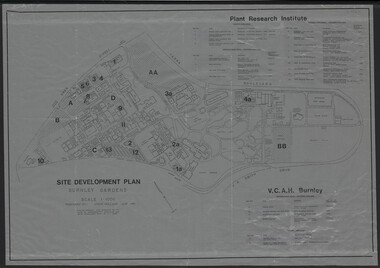 University of Melbourne, Burnley Campus Archives
Plan, Site Development Plan - Burnley Gardens, 1988-1989
Used by Honours student, Linda Hipwell in 1999.(1) Site development plan prepared by Steve Mullany June 1989. Scale 1:1000. Photogrammetric plot prepared for the VCAH by Stereometric Services from aerial photography taken 10.07.1988. Plant Research Institute, proposed major buildings 1989-99. Includes legend. (2) 1 tracing paper copy, 3 paper copies, 1 enlargement (some slight variations). plant research, linda hipwell, vcah, students -
Clunes Museum
Plan - PLANS, Harry E Sando, Borough of Clunes Contract 96.6 of 1893/4, c1894
Harry E Sando C.E. (Borough Enginee) as at 10th March 1894, this plan also signed by the contactor and witness, both signatures are illegibleColoured drawings on tracing/architects papers, pinned with dress makers pins to stiff paper. Scale 2 feet to 1 inchHeadings on plans; "Ground Plan No.1, Ground Plan No.2, Sections of weirscreswick creek, flood mitigation, weir system -
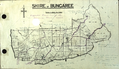 Federation University Historical Collection
Plan, Shire of Bungaree
The former Shire of Bungaree is now part of Moorabool Shire.Plan of the Shire of Bungaree. Scale is 1 inch to 1 mile with the total distance approximately 40 miles. Includes Gong Gong Reservoir, Kirks Reservoir, White Swan Reservoir, Wilson's Reservois and Moorabool Reservoir. Purple line in purple pencil indictaes suggested scenic tour of the Bungaree Shirebungaree, water supply, barkstead, humffray street, ballarat, doveton (north) stret, ballarat, ballarat water commission, great dividing range, wombat state forest, mineral water springs, gong gon reservoir, kirks reservoir -
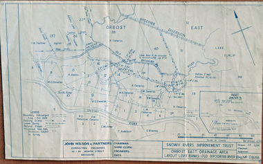 Orbost & District Historical Society
plan, December 1968
Brodribb floodplain regularly inundated in the late 1800s and early 1900s. Works included: clearing the river channel and blocking ‘gulches’. The meander was cut-off in 1931, as part of the Orbost East Drainage Scheme and further developed after 1934 floods and again in the early 1950s when levee banks and a regulator were constructed. (ref. East Gippsland Catchment Management)This is a useful reference tool.A hand-drawn plan of the layout of the levee banks of the Old Brodribb River.brodribb-river map plan-levee-banks -
Federation University Historical Collection
Plan - Mines, Plan of the Sebastopol Plateau Mines
Small printed plan of the Sebastopol Plateau Mines, including Don Co, New Koh-i-nor, Northern Star Co, Band and Loch Co, Star of the East Co, South Star Co, Gay Star Co, Central Plateau Co, South Star Extended, Sebastopol NO 1, Prince of Wales Co, Prince of Wales and Bonshaw United. Verso is an advertisement of r Ballarat Hardware Co.f.w. holst, sharebrokers, cgt, sebastopol plateau, don co, new koh-i-nor, northern star co, band and loch co, star of the east co, south star co, gay star co, central plateau co, south star extended, sebastopol no 1, prince of wales co, prince of wales and bonshaw united, ballarat hardware co, f.w. holst -
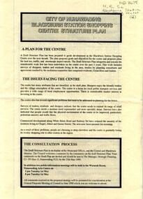 Whitehorse Historical Society Inc.
Pamphlet, City of Nunawading Blackburn Station Shopping Centre structure plan, 1990
Map of land use precincts, draft structure plan including overall strategic goals of Blackburn Station Shopping Centre. Also traffic managementMap of land use precincts, draft structure plan including overall strategic goals of Blackburn Station Shopping Centre. Also traffic management.Map of land use precincts, draft structure plan including overall strategic goals of Blackburn Station Shopping Centre. Also traffic managementblackburn station shopping centre, land use