Showing 25577 items matching "plenty-township-estate"
-
 Linton and District Historical Society Inc
Documents - purchase of land, Purchase of land by David McFadzean, 1872 - Allotment A1A, Township of Linton, Parish of Argyle
The land was purchased by David McFadzean under the 42nd section of the Amending Land Act, 1865. This allowed long-term tenants ("licensees") of government-held land to purchase ("alienate") the land. The allotment is in present-day Jackson Street, Linton.Twelve A4-size photocopies of documents relating to the purchase of an allotment of land - Allotment A1A, measuring 5 acres, 3 roods and 37 perches - within the boundaries of the Township of Linton. First page is headed "SECTION 31, "LAND ACT 1869". Documents include David McFadzean's application to purchase, notes made about the land and the application by officers of the Board of Land and Works, a plan of the allotment, and information about purchase price and fees.allotment a1a township of linton, david mcfadzean, victoria. amending land act 1865, conveyance, land sales, land purchases, documents and records, james beament -
![View of the Township of Fernshawe / [by] Nicholas Caire, circa 1876](/media/collectors/550653872162f11fb04854aa/items/57775425d0cdd10a5c17a3fd/item-media/57775483d0cdd10a5c17c7c0/item-fit-380x285.jpg) Kew Historical Society Inc
Kew Historical Society IncPhotograph, Anglo-Australasian Photographic Company, View of the Township of Fernshawe, c. 1876
Nicholas Caire was born on Guernsey in the Channel Islands in 1837. He arrived in Adelaide with his parents in about 1860. In 1867, following photographic journeys in Gippsland, he opened a studio in Adelaide. From 1870 to 1876 he lived and worked in Talbot in Central Victoria. In 1876 he purchased T. F. Chuck's studios in the Royal Arcade Melbourne. In 1885, following the introduction of dry plate photography, he began a series of landscape series, which were commercially successful. As a photographer, he travelled extensively through Victoria, photographing places few of his contemporaries had previously seen. He died in 1918. Reference: Jack Cato, 'Caire, Nicholas John (1837–1918)', Australian Dictionary of Biography, National Centre of Biography, Australian National UniversityAn original, rare photograph from the series 'Views of Victoria: General Series' by the photographer, Nicholas Caire (1837-1918). The series of 60 photographs that comprise the series was issued c. 1876 and reinforced a neo-Romantic view of the Australian landscape to which a growing nationalist movement would respond. Nicholas Caire was active as a photographer in Australia from 1858 until his death in 1918. His vision of the Australian bush and pioneer life had a counterpart in the works of Henry Lawson and other nationalist poets, authors and painters.Albumen silver photograph mounted on board. [Note: This is the first of two copies of this photograph in the collection]printed in ink on support l.c.: VIEW OF THE TOWNSHIP OF FERNSHAWE. / COPYRIGHT REGISTERED. printed in ink on support reverse c.: VIEWS OF VICTORIA. / (GENERAL SERIES.) / No. 14. / VIEW OF THE TOWNSHIP OF FERNSHAWE. / Fernshawe may be considered the most romantic town in the Colony of Victoria. It is situated at the foot of / the Black Spur, and is surrounded by a great many high hills, such as Mounts Riddell, Juliet, Munday, and others, / which form the crossing range into Gipps Land. It has, no doubt, derived its name from the fact that it is the / greatest Fern-growing district in the Colony. printed in ink on support reverse l.c.l.: J.W. FORBES, Agent, printed in ink on support reverse l.c.: ANGLO-AUSTRALASIAN PHOTOGRAPHIC COMPANY, MELBOURNE. printed in ink on support reverse l.c.r.: 10 Temple Court, Collins Street West.nicholas caire (1837-1918), landscape photography, fernshawe -
![View of the Township of Fernshawe / [by] Nicholas Caire, circa 1876](/media/collectors/550653872162f11fb04854aa/items/57775578d0cdd10a5c183f96/item-media/577755dfd0cdd10a5c18731c/item-fit-380x285.jpg) Kew Historical Society Inc
Kew Historical Society IncPhotograph, Anglo-Australasian Photographic Company, View of the Township of Fernshawe, c. 1876
Nicholas Caire was born on Guernsey in the Channel Islands in 1837. He arrived in Adelaide with his parents in about 1860. In 1867, following photographic journeys in Gippsland, he opened a studio in Adelaide. From 1870 to 1876 he lived and worked in Talbot in Central Victoria. In 1876 he purchased T. F. Chuck's studios in the Royal Arcade Melbourne. In 1885, following the introduction of dry plate photography, he began a series of landscape series, which were commercially successful. As a photographer, he travelled extensively through Victoria, photographing places few of his contemporaries had previously seen. He died in 1918. Reference: Jack Cato, 'Caire, Nicholas John (1837–1918)', Australian Dictionary of Biography,An original, rare photograph from the series 'Views of Victoria: General Series' by the photographer, Nicholas Caire (1837-1918). The series of 60 photographs that comprise the series was issued c. 1876 and reinforced a neo-Romantic view of the Australian landscape to which a growing nationalist movement would respond. Nicholas Caire was active as a photographer in Australia from 1858 until his death in 1918. His vision of the Australian bush and pioneer life had a counterpart in the works of Henry Lawson and other nationalist poets, authors and painters.Albumen silver photograph mounted on board. [Note: This is the second of two copies of this photograph in the collection]printed in ink on support l.c.: VIEW OF THE TOWNSHIP OF FERNSHAWE. / COPYRIGHT REGISTERED. printed in ink on support reverse c.: VIEWS OF VICTORIA. / (GENERAL SERIES.) / No. 14. / VIEW OF THE TOWNSHIP OF FERNSHAWE. / Fernshawe may be considered the most romantic town in the Colony of Victoria. It is situated at the foot of / the Black Spur, and is surrounded by a great many high hills, such as Mounts Riddell, Juliet, Munday, and others, / which form the crossing range into Gipps Land. It has, no doubt, derived its name from the fact that it is the / greatest Fern-growing district in the Colony. printed in ink on support reverse l.c.l.: J.W. FORBES, Agent, printed in ink on support reverse l.c.: ANGLO-AUSTRALASIAN PHOTOGRAPHIC COMPANY, MELBOURNE. printed in ink on support reverse l.c.r.: 10 Temple Court, Collins Street West.nicholas caire (1837-1918), landscape photography, fernshawe -
 Orbost & District Historical Society
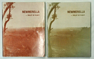
books, Snowy River Mail, Newmerella - Valley of Plenty, March 1978
This book is a useful reference tool on the history of Newmerella.Four copies of a 80 pp soft covered stapled book with a light brown cover with the title, "NEWMERELLA - VALLEY OF PLENTY' in a darker brown print at the top. Below is an illustration of the Snowy River flats. It contains an outline of the history of Newmerella from the beginning of the 19th century until 1978. There are black/white photographs, detailed information and maps.newmerella-history valley-of-plenty -
 Greensborough Historical Society
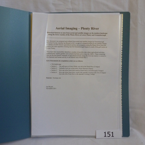
Folder, Aerial Imaging - Plenty River: by Ian Bryant, 2011_11
Investigates early land use along the Plenty River from north of the main aqueduct crossing in Greensborough to south of the golf course in Lower PlentyHistorical features seen from aerial and satellite images of the modern landscape may indicate earlier agricultural land usage.9 x A4 pages of text and colour annotated maps downloaded from nearmap.com.plenty river, ian bryant, lower plenty, greensborough, yallambie park, aerial photography -
 Greensborough Historical Society
Photograph - Digital image, Marilyn Smith, Plenty River bank at Greensborough 2015; Low water level, 16/08/2015
Low water level Plenty River in Greensborough. A River bank stabilisation project along the Plenty River at Greensborough was conducted by Melbourne Water in 2015.Digital copy of colour photographplenty river, melbourne water -
 Greensborough Historical Society
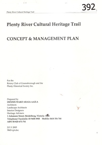
Report, Plenty River Cultural Heritage Trail : Concept & management plan, 2005_07
Prepared for the Rotary Club of Greensborough and Plenty Historical Society by Dennis Ward, this report outlines the heritage importance of the Plenty River Trail around Greensborough.This is an ongoing project by Dennis Ward. This report is an early version of the 2011 Squatters, speculators and settlers: Plenty River Cultural heritage trail. (Item 258) 66 page report, Illus, (some col.) , maps. In red 2-ring binder.Some handwritten notes in last pages.plenty river cultural heritage trail, dennis ward, rotary club of greensborough, plenty historical society, plenty river -
![Book - Article, Fiona Weaver, Lower Plenty River Archaeological Survey by Fiona Weaver [excerpt], 1991](/media/collectors/62fc2e8d3b4c83fe7f279a1c/items/6450d73a49371722cf4f2ee8/item-media/6450d9b949371722cf4f5830/item-fit-380x285.jpg) Heidelberg Golf Club
Heidelberg Golf ClubBook - Article, Fiona Weaver, Lower Plenty River Archaeological Survey by Fiona Weaver [excerpt], 1991
Excerpt from Lower Plenty River Archaeological Survey by Fiona Weaver. Section 5 on Aboriginal archaeological sites in the Lower Plenty River area.A survey of First Nations sites in the Lower Plenty River area.Copy of part of book.lower plenty river, aboriginal sites -
 Sunbury Family History and Heritage Society Inc.
Photograph, Rosa McCall, Old Broadmeadows Township, 1949
The small town in the photograph is the former Broadmeadows Township (now part of Westmeadows). It was situated on the Old Sydney Road (Mickleham Road) and 2 miles east of the Broadmeadows Station. The stone bridge in the foreground spans the Moonee Ponds Creek and Fawkner Street is the road, which leads southwards to Gladstone Park and Tullamarine. The little building was a lolly shop that Mrs. Ethel Mitchell owned and ran for many years.Until 1869, before Sydney Road was finally opened, travellers on their way to Sydney would pass through the Broadmeadows Township.A copy of a non-digital black and white photograph of a road way with a bridge in the foreground leading to a small settlement. Small building with a pitched roof and a verandah is on the RHS of the image and the road leading out of the town is bordered with an avenue of pine trees.old broadmeadows township, fawkner street, moonee ponds creek, westmeadows, bridges -
 Kew Historical Society Inc
Plan - Subdivision Plan, Jaques Estate, 1927
The Kew Historical Society collection includes almost 100 subdivision plans pertaining to suburbs of the City of Melbourne. Most of these are of Kew, Kew East or Studley Park, although a smaller number are plans of Camberwell, Deepdene, Balwyn and Hawthorn. It is believed that the majority of the plans were gifted to the Society by persons connected with the real estate firm - J. R. Mathers and McMillan, 136 Cotham Road, Kew. The Plans in the collection are rarely in pristine form, being working plans on which the agent would write notes and record lots sold and the prices of these. The subdivision plans are historically significant examples of the growth of urban Melbourne from the beginning of the 20th Century up until the 1980s. A number of the plans are double-sided and often include a photograph on the reverse. A number of the latter are by noted photographers such as J.E. Barnes.The Jaques Estate was a small subdivision of eight residential allotments bordering Jaques Street and Barkers Road in what is now Hawthorn East. Advertised in The Argus as being in ‘Upper Hawthorn’ the subdivision was claimed to include: ‘charming villa sites in excellent situations, with every convenience available, and with superior homes surrounding’.subdivision plans - hawthorn, jaques estate -
 Whitehorse Historical Society Inc.
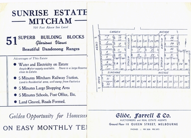
Pamphlet, Sunrise Estate, 1957
Advertising brochure for Sunrise Estate, Mitcham.Advertising brochure for Sunrise Estate, Mitcham. Includes train timetables and list of local factories and schools.Advertising brochure for Sunrise Estate, Mitcham. land subdivision, sunrise estate, mitcham, garden avenue, sunshine avenue, creek road, aylmer avenue, aroona avenue, glide, farrell & co. -
Whitehorse Historical Society Inc.
Letter - Correspondence, Lots on Greenleigh Heights Estate, 1931
A letter to A. Roy Charlesworth, Shire of Blackburn and Mitcham, offering lots for sale at Greenleigh Heughts estate.A letter to A. Roy Charlesworth, Shire of Blackburn and Mitcham, offering lots for sale at Greenleigh Heights estate.A letter to A. Roy Charlesworth, Shire of Blackburn and Mitcham, offering lots for sale at Greenleigh Heughts estate.greenleigh heights estate, charlesworth, albert roy, shire of blackburn and mitcham, land sales -
 Whitehorse Historical Society Inc.
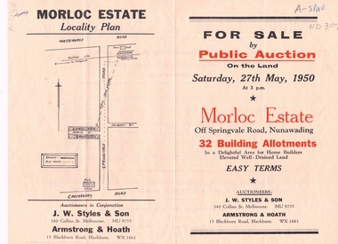
Document, Morloc Estate
Advertising brochure, including plan of landAdvertising brochure, including plan of land for sale in Morloc Estate, Nunawading off Springvale RoadAdvertising brochure, including plan of land morloc estate nunawading, land subdivision, springvale road, nunawading -
Whitehorse Historical Society Inc.
Document, Whitehorse Road Estate
Sale of 158 residential sites in the Whitehorse Road Estate Blackburn.Sale of 158 residential sites in the Whitehorse Road Estate Blackburn by Sole agents Madden & Brady.Sale of 158 residential sites in the Whitehorse Road Estate Blackburn.whitehorse road estate blackburn, madden & brady -
Whitehorse Historical Society Inc.
Map, Blackburn Heights Estate, 1923
Auction plans of sub-division for Blackburn heights Estate.Auction plans of sub-division for Blackburn heights Estate, 130 sites, 8th December 1923Auction plans of sub-division for Blackburn heights Estate.springfield road blackburn north, surrey road blackburn north, gordon street blackburn north, koonung road blackburn north, harris street blackburn north, hirst street blackburn north, deane street blackburn north, blackburn heights estate, blackburn north -
 Whitehorse Historical Society Inc.
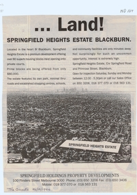
Document, Land! Springfield Heights Estate, Blackburn, 26/10/1994 12:00:00 AM
Springfield Heights Estate; cnr Springfield Road and Primrose Street, Blackburn.Nunawading Gazette advertisement for Springfield Heights Estate; cnr Springfield Road and Primrose Street, Blackburn.Springfield Heights Estate; cnr Springfield Road and Primrose Street, Blackburn.springfield heights estate, springfield road, blackburn north, primrose street, springfield holdings property developments, residential development -
Whitehorse Historical Society Inc.
Document, Sunfield Estate, 3/12/1955 12:00:00 AM
73 home sites at Sunfield Estate to be Auctioned by Frank Fisher & Co. on 3 Dec 1955.73 home sites at Sunfield Estate to be Auctioned by Frank Fisher & Co. on 3 Dec 1955.73 home sites at Sunfield Estate to be Auctioned by Frank Fisher & Co. on 3 Dec 1955.sunfield estate, frank fisher co., middleborough road, box hill, first avenue, box hill, second avenue, box hill, third avenue, box hill, eram road, box hill -
Whitehorse Historical Society Inc.
Document, Tunstall Town Estate, 1/03/1926 12:00:00 AM
Auction brochure of Tunstall Town Estate.Auction brochure of Tunstall Town Estate, cnr Whitehorse and Springvale Roads, Tunstall by Coghill & Haughton.Auction brochure of Tunstall Town Estate. kelly, john james, tunstall town estate, whitehorse road, tunstall, springfield road, tunstall, coghill & haughton, glendale street, nunawading, silver grove, nunawading, railway parade, nunawading -
 Greensborough Historical Society
Photograph - Digital image, Marilyn Smith, Plenty River bank stabilisation 2015; path along the river, 16/08/2015
River bank stabilisation project along the Plenty River at Greensborough 2015, conducted by Melbourne Water. This photo shows the path beside the Plenty River in Greensborough.Digital copy of colour photographplenty river, melbourne water -
 Greensborough Historical Society
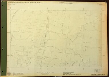
Map, Melbourne and Metropolitan Board of Works. Survey Division, MMBW, Yarra 2500 / 14.24. Plenty, 1979_05
Melbourne and Metropolitan Board of Works. Yarra 2500 [base map] 14.24. Plenty. Parishes of Nillumbik 3310 and Morang 3183. Municipality of Diamond Valley 257. Prominent streets include: Heard Road, Hillmartin Road and Yan Yean Road. Features include Plenty Primary School and Plenty Park.MMBW Map in 1:2500 [scale] series. Cream parchment with green tape reinforcing on edges and punched holes on left edge.mmbw, melbourne and metropolitan board of works, shire of diamond valley, plenty - maps -
 Eltham District Historical Society Inc
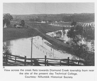
Work on paper (Sub-Item) - Photograph, View across the creek flats towards Diamond Creek township
Undated black and white photograph of view across the creek flats towards Diamond Creek township showing the railway line, with the Diamond Creek under flood. Situated behind the vicinity of Diamond Valley College, Main Hurstbridge Road, Diamond Creek. Diamond Valley College was formed in 1989 from the almagamation of Diamond Creek Technical School and Hurstbridge High School. Nillumbik Historical Society collectionflood, diamond creek, nillumbik historical society -
 Ringwood and District Historical Society
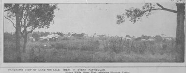
Photograph, Image used for land sale promotion of Pratt's Junction Estate opposite Mount Dandenong Road, Ringwood - 24/11/1923
Catalogue card reads, "Pratt's Junction Estate - 24/11/1923, 86 lots". -
 Ringwood and District Historical Society
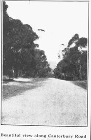
Photograph, Image used for land sale promotion of Coleman's Heathmont Estate, looking east along Canterbury Road, Heathmont. Sale 15/12/1923 by Public Auction
Catalogue card reads, "Coleman's Heathmont Estate - 1923. Sale 15/12/1923." -
 Kew Historical Society Inc
Plan - Subdivision Plan, Riversdale Estate, 1939
The Kew Historical Society collection includes almost 100 subdivision plans pertaining to suburbs of the City of Melbourne. Most of these are of Kew, Kew East or Studley Park, although a smaller number are plans of Camberwell, Deepdene, Balwyn and Hawthorn. It is believed that the majority of the plans were gifted to the Society by persons connected with the real estate firm - J. R. Mathers and McMillan, 136 Cotham Road, Kew. The Plans in the collection are rarely in pristine form, being working plans on which the agent would write notes and record lots sold and the prices of these. The subdivision plans are historically significant examples of the growth of urban Melbourne from the beginning of the 20th Century up until the 1980s. A number of the plans are double-sided and often include a photograph on the reverse. A number of the latter are by noted photographers such as J.E. Barnes.The Riversdale Estate in Hawthorn created a subdivision of 20 allotments bordering on Riversdale Road and Riversdale Court (which was created by the subdivision). The Locality Plan at right lists the major public buildings in the area: Burnely Horticultural Gardens, Hawthorn Tram Depot and Railway Station, Scotch College and the River Yarra and The Boulevard.subdivision plans - hawthorn, riversdale estate -
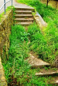 Greensborough Historical Society
Photograph - Digital image, Marilyn Smith, Plenty River bank stabilisation 2015; Steps to path, 16/08/2015
This photo shows the steps to the path beside the Plenty River in Greensborough. A River bank stabilisation project along the Plenty River at Greensborough was conducted by Melbourne Water in 2015.Digital copy of colour photographplenty river, melbourne water -
 Greensborough Historical Society
Map, Melbourne and Metropolitan Board of Works. Survey Division, MMBW, Yarra 2500 / 13.23. Plenty, Middle Gorge, 1978_04
Melbourne and Metropolitan Board of Works. Yarra 2500 [base map] 13-23. Plenty / Middle Gorge. Parish of Morang 3183. Municipalities of Diamond Valley 257 and Whittlesea 239. Prominent streets include: Gorge Road, Kurrak Road and Browns Lane. Features include the Plenty River and Plenty Gorge Park.MMBW Map in 1:2500 [scale] series. Cream parchment with green tape reinforcing on edges and punched holes on left edge.mmbw, melbourne and metropolitan board of works, shire of diamond valley, plenty - maps, plenty gorge park -
 Kew Historical Society Inc
Plan - Subdivision Plan, Camberwell Mountain View Estate, 1923
The Kew Historical Society collection includes almost 100 subdivision plans pertaining to suburbs of the City of Melbourne. Most of these are of Kew, Kew East or Studley Park, although a smaller number are plans of Camberwell, Deepdene, Balwyn and Hawthorn. It is believed that the majority of the plans were gifted to the Society by persons connected with the real estate firm - J. R. Mathers and McMillan, 136 Cotham Road, Kew. The Plans in the collection are rarely in pristine form, being working plans on which the agent would write notes and record lots sold and the prices of these. The subdivision plans are historically significant examples of the growth of urban Melbourne from the beginning of the 20th Century up until the 1980s. A number of the plans are double-sided and often include a photograph on the reverse. A number of the latter are by noted photographers such as J.E. Barnes.The so-called Camberwell Mountain View Estate was a subdivision on ‘the corner [of] Burke Road, Eyre and Wills Streets, Deepdene’. The Estate was not the first attempt to subdivide this land holding. In 1884, 1888 and 1894 the Belmore Park subdivision proposed 18 allotments for this parcel of land. The final stages of the Belmore Park subdivision occurred during the Depression of the 1890s. Apart from perhaps one block facing Burke Road, which is unnumbered in the Mountain View Estate subdivision, the rest must have remained unsold. The later subdivision would redraw the original 18 allotments, creating 22 new lots. In the Locality Plan on the left side of the subdivision plan, Deepdene Station, which formed part of the Outer Circle Railway is represented, as is the location of Deepdene Primary School. A selling point was the proposed extension of the Burke Road tram beyond its terminus at Cotham Road. The extension did not eventuate.subdivision plans - camberwell, mountain view estate -
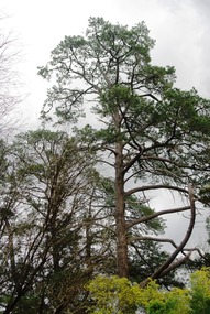 Greensborough Historical Society
Photograph - Digital image, Marilyn Smith, Plenty River bank at Greensborough 2015; Tree, 16/08/2015
This photo shows examples of trees growing beside the Plenty River in Greensborough. A River bank stabilisation project along the Plenty River at Greensborough was conducted by Melbourne Water in 2015.Digital copy of colour photographplenty river, melbourne water -
 Heidelberg Golf Club
Book, Melbourne Parks and Waterways, Lower Plenty River concept plan: Maroondah Pipe Track to Yarra River, 1994
Lower Plenty River concept plan: Maroondah Pipe Track to Yarra River. Includes suggestion of Plenty River Trail along the west boundary of the Heidelberg Golf Club.66 p., illus., colour map. Also, Draft copy of document.plenty river trail, lower plenty river, heidelberg golf club, mmbw, melbourne parks and waterways -
 Eltham District Historical Society Inc
Photograph, Amberley, Lower Plenty; Autumn Excursion to Lower Plenty area, 18 April 1998, 18/04/1998
Looking westerly across the Yarra from Westerfolds Park you can see a large and imposing building at the top of the escarpment above the river. This is the Christian Brothers Training Centre at Lower Plenty and known as Amberley. This significant building dates from 1930 when it was the rather grand residence of Oswald Darch. It was purchased by the Catholic Church in 1955 and has since been significantly extended.Roll of 35mm colour negative film, 2 stripsKodak Gold 200-6activities, lower plenty, amberley