Showing 4080 items
matching road plans
-
 Greensborough Historical Society
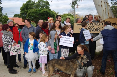
Photograph - Digital Image, Diamond Valley Tree Protest 2019 - people, 25/07/2019
A redevelopment of the Diamond Village area included a multi storey apartment block which required the removal of this tree (Tree 10) on the plans. A VCAT decision ruled that the development be no higher than 4 storeys, and a maximum of 15 dwellings. This photograph shows local residents protesting at the development and removal of tree in July 2019.Digital copy of colour photographsdiamond village shopping centre, diamond village, nepean street watsonia -
 Greensborough Historical Society
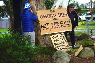
Photograph - Digital Image, Diamond Valley Tree Protest 2019 - signs, 25/07/2019
A redevelopment of the Diamond Village area included a multi storey apartment block which required the removal of this tree (Tree 10) on the plans. A VCAT decision ruled that the development be no higher than 4 storeys, and a maximum of 15 dwellings. This photograph shows local residents placing protest signs at the base of the tree in July 2019.Digital copy of colour photographsdiamond village shopping centre, diamond village, nepean street watsonia -
 Greensborough Historical Society
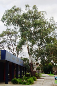
Photograph - Digital Image, Diamond Valley Tree Protest 2019 - Tree 10, 25/07/2019
A redevelopment of the Diamond Village area included a multi storey apartment block which required the removal of this tree (Tree 10) on the plans. A VCAT decision ruled that the development be no higher than 4 storeys, and a maximum of 15 dwellings. This photograph shows Tree 10 in situ in July 2019.Digital copy of colour photographdiamond village shopping centre, diamond village, nepean street watsonia -
 Greensborough Historical Society
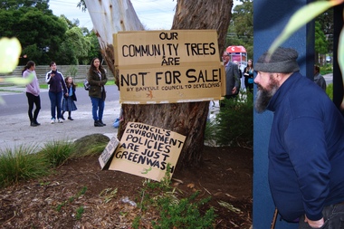
Photograph - Digital Image, Diamond Valley Tree Protest 2019 - GHS members, 25/07/2019
A redevelopment of the Diamond Village area included a multi storey apartment block which required the removal of this tree (Tree 10) on the plans. A VCAT decision ruled that the development be no higher than 4 storeys, and a maximum of 15 dwellings. This photograph shows several GHS members at the protest in July 2019.Digital copy of colour photographsdiamond village shopping centre, diamond village, nepean street watsonia -
 Lorne Historical Society
Map - Subdivision Map, J Batten Lithos, Plan of West Lorne Loutitt Bay Allotments IV and V
One of the early subdivision maps of Lorne.Black and white printed map on cream paper. The map shows allotments from the Erskine River to the Grand Pacific with an inset of allotments between Smith and Otway Streets. Allotments have the owners names.. The sea baths, Cobb and Co stables , Mountjoys Hotel, the Church of England, the telegraph line to Geelong and the jetty are also marked.lorne, subdivisions, -
 Greensborough Historical Society
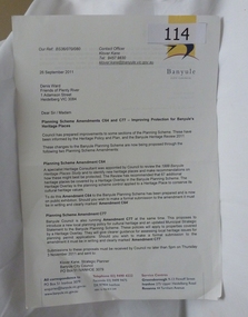
Letter - Correspondence, Banyule City Council, Planning scheme amendments c64 and c77 - improving protection for Banyule's Heritage Places, 26/09/2011
Deals with those places in the City of Banyule that have been proposed to be covered in Heritage Overlay. Outline amendments to Banyule Planning Scheme in relation to Heritage places.The Heritage Overlay is the planning scheme control applied to an identified Heritage place or precinct to protect its cultural heritage values.A4. Letter and accompanying documents printed on white paper. Total 20 pages. Banyule City Council letterheadbanyule city council, heritage overlay -
 Greensborough Historical Society
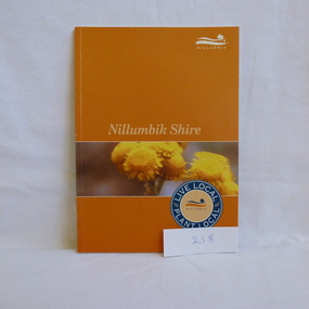
Book, Nillumbik Shire Council, Live local Plant local: Nillumbik Shire, 2001_
Nillumbik Shire is known for its natural vegetation. This text encourages locals to plant indigenous plants in their gardens.A guide to indigenous vegetation in the Nillumbik Shire.56 pages, illus. (some col.). Cover has yelloe flowers in band on orange background with shire logo.nillumbik shire council, environmental and cultural planning section, chris delaney, indigenous plants, native gardens -
 Greensborough Historical Society
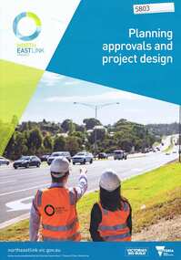
Pamphlet, Victorian Government, Planning approvals and project design: North East Link Project, 2018_09
Describes the use of an environment effects statement (EES) in the planning approval and project design process for the North East Link. 6 p., col. photographs and chartsnorth east link -
 Greensborough Historical Society
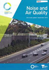
Pamphlet, Victorian Government, Noise and air quality: ESS Study Update, 2018_09
Part of the Environmental Effects Statement for the North East Link planning approval process. This volume covers noise and air quality.6 p., col. photographsnorth east link -
 Greensborough Historical Society
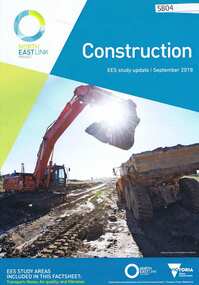
Pamphlet, Victorian Government, Construction: EES study update, 2018_09
Part of the EES Study update for planning approval process for the North East Link. This volume covers Construction.6 p., col. photographsnorth east link -
 Greensborough Historical Society
Pamphlet, Victorian Government, Environment: EES study update, 2018_09
Forms part of the EES study update for planning approval process for the North East Link. This volume covers Ecology (flora, fauna and aquatic), groundwater and surface water6 p., col. photographsnorth east link -
 Greensborough Historical Society
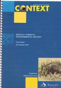
Book, Context (GML Heritage Victoria Pty Ltd), Banyule thematic environmental history: final report, 2018_10
Report on and development of heritage themes relating to forms and places in the City of Banyule area, including places associated with Aboriginal people. Final report prepared for Banyule City Council by Context.82 p., spiral bound, colour and black and white photographs and planscity of banyule, heritage places -
 Greensborough Historical Society
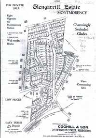
Plan, Coghill and Son, Glengarriff Estate Montmorency, 1938c
Plan for the Glengarriff Estate covers 171 lots in vicinity of Montmorency Railway Station, for private sale, controlling agents Coghill & Son, Local Agents Shallard Bros, Main Road Eltham. C/T 6068/1213512 formerly owned by George Nicholson, dentist.Black and white photocopy of a real estate agent's plan of subdivision montmorency, glengarriff estate montmorency, calrossie street montmorency -
 Greensborough Historical Society
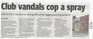
Newspaper Clipping, Diamond Valley Leader, Club vandals cop a spray, 06/02/2019
Vandals are continuing to target Partingtons Flat in Greensborough and Olympic Park in Heidelberg West. Banyule Council has implemented a graffiti management plan.News article 1 page, black text.greensborough, partingtons flat, graffiti -
 Greensborough Historical Society
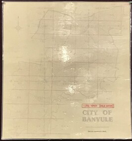
Map, Banyule City Council, MMBW, 1:2500 Series. City of Banyule. Master overlay, 1994_
This master overlay is the key to the Melbourne and Metropolitan Board of Works maps: MMBW, 1:2500 Series. The overlay was made by the City of Banyule using the Melways base plan (Edition 23, 1994-95). This overlay can be used to position maps in this series.Laminated map, with overlay of MMBW map grid.mmbw, melbourne and metropolitan board of works, banyule city council -
 Greensborough Historical Society
Map, Melbourne and Metropolitan Board of Works. Survey Division, MMBW, Yarra 2500 / 13.21. Central Greensborough, 1979_05
Melbourne and Metropolitan Board of Works. Yarra 2500 [base map]. 13-21, Parishes of Keelbundora 2856 and Nillumbik 3310, Municipality of Diamond Valley 257. Shows street names, easement sizes, lot numbers, lodged plan numbers, names of prominent features, contour values, creek or river names. Central Greensborough. Prominent streets: Main Street, Para Road, St Helena Road and Diamond Creek Road.MMBW Map in 1:2500 [scale] series. Cream parchment with green tape reinforcing on edges and punched holes on left edge.mmbw, melbourne and metropolitan board of works, shire of diamond valley, greensborough - maps -
 Greensborough Historical Society
Map, Melbourne and Metropolitan Board of Works. Survey Division, MMBW, Yarra 2500 / 12.20. Watsonia Railway Station and environs, 1983_03
Melbourne and Metropolitan Board of Works. Yarra 2500 [base map]. 12-20, Parishes of Keelbundora 2856, Municipalities of Diamond Valley 257 and 228. Shows street names, easement sizes, lot numbers, lodged plan numbers, names of prominent features, contour values, creek or river names. Watsonia Railway Station and environs. Prominent streets: Watsonia Road, Elder Street, Morwell Avenue and Nepean Street. Includes former Watsonia Technical School and Gresswell Rehabilitation Centre sites.MMBW Map in 1:2500 [scale] series. Cream parchment with green tape reinforcing on edges and punched holes on left edge.mmbw, melbourne and metropolitan board of works, shire of diamond valley, watsonia - maps -
 Greensborough Historical Society
Map, Melbourne and Metropolitan Board of Works. Survey Division, MMBW, Yarra 2500 / 12.19. Watsonia, Simpson Army Barracks, 1983_03
Melbourne and Metropolitan Board of Works. Yarra 2500 [base map]. 12-19, Parish of Keelbundora 2856, Municipalities of Diamond Valley 257 and 228. Shows street names, easement sizes, lot numbers, lodged plan numbers, names of prominent features, contour values, creek or river names. Watsonia Barracks (Simpson Army Barracks) and environs. Prominent streets: Yallambie Road, Greensborough Road, and Strathallan Road. MMBW Map in 1:2500 [scale] series. Cream parchment with green tape reinforcing on edges and punched holes on left edge.mmbw, melbourne and metropolitan board of works, shire of diamond valley, watsonia - maps -
 Greensborough Historical Society
Map, Melbourne and Metropolitan Board of Works. Survey Division, MMBW, Yarra 2500 / 12.22. Watsonia North, 1978_03
Melbourne and Metropolitan Board of Works. Yarra 2500 [base map]. 12-22, Parishes of Keelbundora 2856, Municipalities of Whittlesea 239 and Diamond Valley 257. Shows street names, easement sizes, lot numbers, lodged plan numbers, names of prominent features, contour values, creek or river names. Watsonia Railway Station and environs. Prominent streets: Edmund Rice Parade and Macorna Street. Includes Christian Brothers Edmund Rice College and Janefield Special School sites and "proposed future freeway" (now Metropolitan Ring Road).MMBW Map in 1:2500 [scale] series. Cream parchment with green tape reinforcing on edges and punched holes on left edge.mmbw, melbourne and metropolitan board of works, shire of diamond valley, watsonia - maps, bundoora - maps -
 Greensborough Historical Society
Map, Melbourne and Metropolitan Board of Works. Survey Division, MMBW, Yarra 2500 / 12.21. Watsonia North, 1979_02
Melbourne and Metropolitan Board of Works. Yarra 2500 [base map]. 12-22, Parish of Keelbundora 2856, Municipality of Diamond Valley 257. Shows street names, easement sizes, lot numbers, lodged plan numbers, names of prominent features, contour values, creek or river names. Watsonia Railway Station and environs. Prominent streets: Grimshaw Street, William Street and Macorna Street. Includes former Institute of Social Welfare (now Loyola College) Lines Reserve and Binnak Park.MMBW Map in 1:2500 [scale] series. Cream parchment with green tape reinforcing on edges and punched holes on left edge.mmbw, melbourne and metropolitan board of works, shire of diamond valley, watsonia - maps, bundoora - maps -
 Greensborough Historical Society
Map, Melbourne and Metropolitan Board of Works. Survey Division, MMBW, Yarra 2500 / 12.24. Plenty and Blue Lake, 1977_10
Melbourne and Metropolitan Board of Works. Yarra 2500 [base map]. 12-24, Municipalities of Whittlesea 239 and Diamond Valley 257. Shows street names, easement sizes, lot numbers, lodged plan numbers, names of prominent features, contour values, creek or river names. Watsonia Railway Station and environs. Prominent streets: Memorial Drive. Includes Plenty River and Blue Lake in the Plenty Gorge.MMBW Map in 1:2500 [scale] series. Cream parchment with green tape reinforcing on edges and punched holes on left edge.mmbw, melbourne and metropolitan board of works, shire of diamond valley, plenty - maps, blue lake -
 Greensborough Historical Society
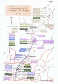
Maps, Yan Yean Water Supply System Conservation Management Plan: Construction dates Map 1, 2007_
Plan of Yan Yean Water Supply System, showing natural and constructed features from 1850s to 1930s from Silver Creek Weirs to Eastern Freeway.Printed in colour one side. 3 copieswater supply, yan yean reservoir, plenty river -
 Greensborough Historical Society
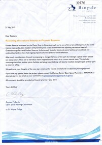
Letter, Restoring the natural beauty at Pioneer Reserve, 21/05/2019
Letter to residents, outlining plans to renovate Pioneer Reserve Greensborough by introducing native vegetation and returning it to a more natural state. This includes removing the toilets, picnic shelter and playground.2 p. letter, coloured aerial photograph on back pagepioneer reserve greensborough, banyule council -
![Book - Excerpt, Bundoora Park: a cultural history and conservation plan [excerpt], 1996_](/media/collectors/4f729f5697f83e03086015b8/items/5d12dea021eb0b115454732c/item-media/5d12df0a21eb0b115454d87f/item-fit-380x285.jpg) Greensborough Historical Society
Greensborough Historical SocietyBook - Excerpt, Bundoora Park: a cultural history and conservation plan [excerpt], 1996_
Aspects of Bundoora Homestead, particularly John Smith and his champion racehorse Wallace; and descriptions of the exterior of the mansion in 1910.5 p. photocopied excerpt, black & white text.Pages 13, 38-39,50-51.bundoora homestead -
 Greensborough Historical Society
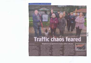
Newspaper Clipping, Diamond Valley Leader, Traffic chaos feared, 26/06/2019
A plan to develop a six-storey apartment complex next to Greensborough station will cause a "chaotic traffic disaster", concerned residents say.News article 1 page, black text and colour image.greensborough station, apartment complex, poulter avenue greensborough, banyule city council -
 Greensborough Historical Society
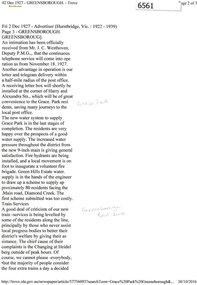
Newspaper Clipping (copy), Greensborough. 2 Dec 1927, 02/12/1927
Article describing new utilities in the Greensborough district: continuous telephone service; letter and telegram delivery within a half-mile radius of the post office; new water system to supply Grace Park, and plans to supply water to the Greenhills Estate, and comments on the train service from Heidelberg to Eltham.2 p. typescript (OCR transcript of original article, copied from Trove)water supply, postal services, railways, greenhills, grace park, telephone service, greensborough -
 Greensborough Historical Society
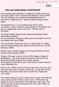
Document, The Old Heidelberg Courthouse, 2018_
The Courthouse is now the location of the Heidelberg Historical Society.2 p. black print on pink paper, building planheidelberg historical society, old heidelberg court house -
 Greensborough Historical Society
Newspaper Clipping, Diamond valley Leader, Calls for council merger, 31/07/2019
Urban sprawl and the cost of rates are some of the key concerns raised by 'stunned' ratepayers after a councillor revealed shocking plans to merge Banyule and Nillumbik councils last week.News article 1 page, black text.nillumbik council, council merger, peter clarke, banyule city council -
 Greensborough Historical Society
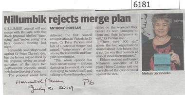
Newspaper Clipping, Herald/Sun Newspaper, Nillumbik rejects merge plan, 31/07/2019
Nillumbik council will not merge with Banyule, with the shock proposal labelled "damaging" and "embarrassing" at the fiery council meeting last night.News article 1 page, black text.nillumbik council, council merger, peter clarke, banyule city council -
 Greensborough Historical Society
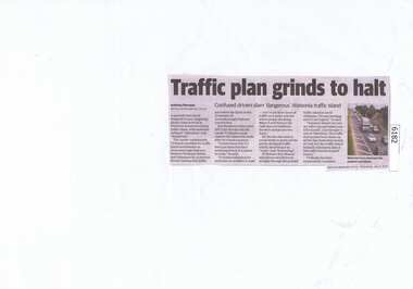
Newspaper Clipping, Diamond valley Leader, Traffic plan grinds to halt, 31/07/2019
A painted road island designed to ease congestion along a busy arterial in Watsonia (Greensborough Highway) is instead causing traffic chaos, with motorists calling it "ridiculous" and "dangerous".News article 1 page, black text.greensborough highway, watsonia, traffic chaos