Showing 173372 items matching "street"
-
 Federation University Historical Collection
Document, Graeme Tyrrell, Overview for the Development of Gardens Lydiard Street Campus, 1988, 01/12/1988
The report was prepared by Graeme Tyrrell, headgroundsman/Gardener at the Ballarat School of Mines (SMB) for Bob Feary, Manager of Facilities at SMB. The report was designed to present a broad cover of current plans for specific sites at the Lydiard Street campus.Seven page report on the development of the Ballarat School of Mines Gardens, including the Motor Mechanics Portable, Hickman Street (now demolished); Recreation Building (now demolished), E.P.U.Y Building, Hickman Street, vacant block behind creche (now site of UBTec building); Creche, Grant Street (now demolished); Former Courthouse building, Grant Street terrace, Brick Court yard, conifer beds lining Lydiard Street, Herb Garden above M.B. John Building, Terrraced area above Ballarat School of Mines Botanical Garden (referred to as Von Mueller garden). The report includes a campus plan. The report is copied onto white paper and is stapled at the top left corner. ballarat school of mines botanical gardens, ballarat school of mines, bob feary, graeme tyrrell, gardens, ballarat school of mines campus, smb campus -
 St Kilda Historical Society
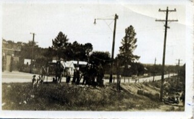
Photograph, Marnie Mahong, Camden Street carpark, Balaclava, 11/1962
Opening of carpark Camden Street Balaclava black and white photograph, unmounted, original, good conditionOn back: Opening of Car Park Camden Street Nov 1962. This group of photos from Marnie Mahong. From Leete Chemist -
 Tatura Irrigation & Wartime Camps Museum
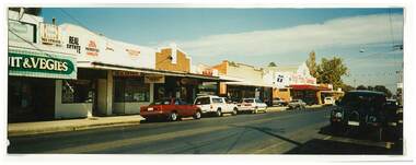
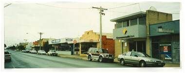
Photograph, Hogan Street, Tatura
Shows picture of a few of the businesses in Hogan Streets, Tatura. Fresh Fruit and Vegies, Newsagents, real estate, Kings Family Tuckerbag.Colour photograph showing a few of the businesses in Hogan Streets, Tatura. Photograph stuck onto piece of white cardboard. hogan street tatura, tatura businesses, tatura newsagency, kings family tuckerbag -
Hume City Civic Collection
Book - Street Directory, Gregory"s Melbourne Street Directory
This 1972 Gregory's Melbourne Street Directory published by Gregory's Guides & Maps Pty Ltd was used by the donor, her husband and family.A black leather removable cover with gold embossed vintage car on the front enclosing a Gregory's Melbourne Street Directory.Gold embossed vintage car on front cover.joan houston, maps, street directory, roads, suburbs -
 Eltham District Historical Society Inc
Photograph, East end of Bridge Street, Eltham, 7 August 1967, 1967
Showing McMahon Ball fence. William McMahon Ball, University Professor lived in York Street.35mm Colour positive transparency Mount - Agfacolor Service (Blue stepped)Inscribed EB (b)bridge street, eltham, houses, mcmahon ball -
 Greensborough Historical Society
Advertising Leaflet, 5 Willis Street Greensborough, 13/04/2013
5 Willis Street Greensborough Four bedroom home, sold for $693,000 13/04/2013Real estate advertising leaflet, 1 sheet, printed in colour both sides. 2 copieswillis street greensborough, greenhills -
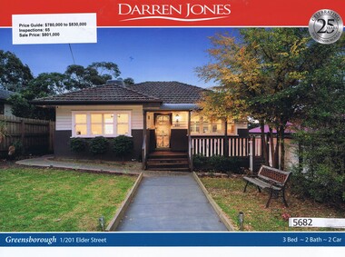 Greensborough Historical Society
Advertising Leaflet, Darren Jones, 1/201 Elder Street Greensborough, 18/11/2017
1/201 Elder Street Greensborough. Three bedroom home, sold for $801,000 in November 2017. Real estate advertising leaflet, 1 sheet, printed in colour both sides. elder street greensborough -
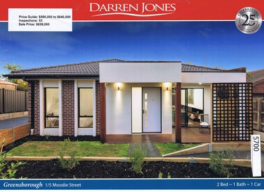 Greensborough Historical Society
Advertising Leaflet, Darren Jones, 1/5 Moodie Street Greensborough, 03/03/2017
1/5 Moodie Street Greensborough. Two bedroom unit, sold for $638,000 in March 2017.Real estate advertising leaflet, 1 sheet, printed in colour both sides. moodie street greensborough -
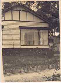 Greensborough Historical Society
Photograph - Digital image, Jessie Partington's house, Carnon Street, 1940c
This house in Carnon Street Greensborough was the home of Jessie Partington. It was demolished around 2005 for a block of units.Digital copy of black and white photograph.jessie may partington, jessie angus, jessie scholes, carnon street -
 Eltham District Historical Society Inc
Photograph, Margaret Ball, Arthur Street, Eltham, c.June 1999, 1999
Car park after Miss Martin's houses were removed through to Dudley Street, 1999The Margaret Ball (Pre 1960s Houses) Collection was a personal project initiated to mark the year 2000 and arose as a result of the disappearance of many pre-1960s parts of Eltham due to development. Approximately 200 pre-1960s style houses that were left in Eltham between Main Road and east to Bible Street, between Cecil Street to the north and south to Dalton Street were photographed in late 1999. Not all of the houses could be photographed; some because the garden or trees blocked the view of the house, others because of rubbish or cars were in the way, some because people were working on the house or in the gardens at the time.Colour photographic print eltham, houses, streets, margaret ball (pre 1960s houses) collection, carparks -
 Eltham District Historical Society Inc
Photograph, View from lounge room looking towards Pitt Street and Wattle Grove, 218 Pitt Street, Eltham, c.1985, 1985c
House was rented by Kim Tarpey between October 1983 and June 1985. It was one of the buildings originally part of Birds Orchard. Harold Bird was her landlord, a retired primary school teacher who, when she knew him was driving the mobile library bus. Her partner had him as a teacher at Montmorency Primary in grade 4. The house was next door to what is now a bushland reserve near the Pauline Toner Reserve. It was on the corner of Pitt and Arthur St - the driveway was near the roundabout and went off to the right of the driveway that now belongings to 220 Pitt street and which was bushland at the time. It was sold in 1985 and consequently demolished, a large house has replaced it. It was situated approximately where the front door of No. 218 is nowadays with the facade roughly in line with the now garage wall to the left of this front door.Digital file only - scanned from personal photo album on loan218 pitt street, eltham, houses, birds orchard, harold bird, kim tarpey, eucalyptus road -
 Eltham District Historical Society Inc
Photograph, View from back fence looking towards Pitt Street and Wattle Grove, 218 Pitt Street, Eltham, c.1985, 1985c
House was rented by Kim Tarpey between October 1983 and June 1985. It was one of the buildings originally part of Birds Orchard. Harold Bird was her landlord, a retired primary school teacher who, when she knew him was driving the mobile library bus. Her partner had him as a teacher at Montmorency Primary in grade 4. The house was next door to what is now a bushland reserve near the Pauline Toner Reserve. It was on the corner of Pitt and Arthur St - the driveway was near the roundabout and went off to the right of the driveway that now belongings to 220 Pitt street and which was bushland at the time. It was sold in 1985 and consequently demolished, a large house has replaced it. It was situated approximately where the front door of No. 218 is nowadays with the facade roughly in line with the now garage wall to the left of this front door.Digital file only - scanned from personal photo album on loan218 pitt street, eltham, houses, birds orchard, harold bird, kim tarpey, eucalyptus road -
 Eltham District Historical Society Inc
Photograph, View from back fence on to Eucalyptus Road. Pitt Street Reserve to the right, 18 Pitt Street, Eltham, c.1985, 1985c
House was rented by Kim Tarpey between October 1983 and June 1985. It was one of the buildings originally part of Birds Orchard. Harold Bird was her landlord, a retired primary school teacher who, when she knew him was driving the mobile library bus. Her partner had him as a teacher at Montmorency Primary in grade 4. The house was next door to what is now a bushland reserve near the Pauline Toner Reserve. It was on the corner of Pitt and Arthur St - the driveway was near the roundabout and went off to the right of the driveway that now belongings to 220 Pitt street and which was bushland at the time. It was sold in 1985 and consequently demolished, a large house has replaced it. It was situated approximately where the front door of No. 218 is nowadays with the facade roughly in line with the now garage wall to the left of this front door.Digital file only - scanned from personal photo album on loan218 pitt street, eltham, houses, birds orchard, harold bird, kim tarpey, eucalyptus road -
 Ringwood and District Historical Society
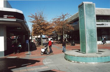
Photograph, Melbourne Street Mall, c2000
Colour photographs (16)Various street scenes within the Melbourne Street Mall -
 Kew Historical Society Inc
Leisure object, Child's Puzzle : Denmark Street Baby Health Centre, c.1950s
In August, 1920, The Kew Town Council decided to establish a Baby Health Centre in Kew. The first Centre was opened in a room in the Town Hall in Walpole Street on 5 November 1920. In May 1939, the Railway Commissioners agreed to lease a site at the Kew Railway Station for a Baby Health Centre for a term of 21 years at 3 pounds per annum. A building, designed by Roland Chipperfield, was erected, and the Centre previously conducted at the Town Hall transferred there. This became known as the Denmark Street Baby Health Centre. (Cr. W.D. Vaughan, Kew’s Civic Century, W.D. Vaughan Pty Ltd., Kew, 1960, pp.96 & 97.)One of a pair of wooden puzzles used in the Denmark Street Baby Health Centre in Kew.denmark street baby health centre - kew (vic), baby health centres - kew (vic), games and puzzles -
Port Melbourne Historical & Preservation Society
Manual, Collins Street Directory 1961, 1961
This compact Collins Street Directory has 178 detailed maps and shows postal district numbers used at that time.Small directory of Melbourne streets in 1961 including a separate map of all areas covered by the directory & their map reference numbers.built environment - civic, collins book depot {ty ltd -
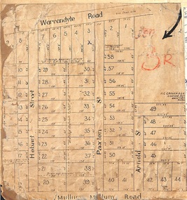 Ringwood and District Historical Society
Map, Residential Subdivision Allotment Layout on Mullum Mullum Road, Hobart Street, Paxton Street, Arnold Street and Warrandyte Road, Ringwood, Vic. circa 1920
One of 3 unrelated land subdivision maps on cardboard backing.H.C. Crouch, Licensed Surveyor, 443 Lt Collins Street, Melbourne. -
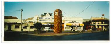 Tatura Irrigation & Wartime Camps Museum
Photograph, Clock Tower intersection, Hogan Street, Tatura
Shows picture of businesses at the Clock Tower intersection, Hogan Street, Tatura,.Colour photograph showing intersection where the Clock Tower is located in Hogan Street, Tatura. Photograph stuck onto piece of white cardboard. hogan street tatura, criterion hotel tatura, max's supermarket tatura, tatura handyman's hardware, tatura florist, tatura post office -
 Tatura Irrigation & Wartime Camps Museum
Photograph, Commonwealth Bank Hogan Street Tatura
Shows picture of Mechanics Institute and Victory Hall, Hogan Street, Tatura. Colour photograph showing Commonwealth Bank in Hogan Street, Tatura and business to the left of the Bank. Photograph stuck onto piece of white cardboard. hogan street tatura, commonwealth bank tatura -
 Greensborough Historical Society
Photograph - Digital Image, Marilyn Smith, Were Street Christmas celebrations 2018. Activity bus, 2018_12
The 2018 Christmas celebration in Were Street Montmorency included this activity bus (Gym Bus) for children to play in.Digital copy of colour photograph.were street montmorency, were street montmorency christmas 2018 -
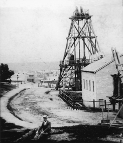 Stawell Historical Society Inc
Photograph, Sloane's & Scotchman Mining Co Poppet Head in Upper Main Street Big Hill looking West. c1890
Gentleman sitting in front of Sloane's & Scotchman Mining Co Poppet Head Upper Main Street Big Hill looking West. Main Street visible in distance background.Poppet head above shaft and engine shed at right. Looking towards corner of Main and Lazelle Streets. Man seated at front centre of photo in boater hat.stawell mining, streetscape -
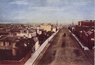 Ballarat Heritage Services
Photograph - Image, Collins Street, Melbourne, from Spring Street, 1870
A colour image of Collins Street, Melbourne.melbourne, collins street, streetscape -
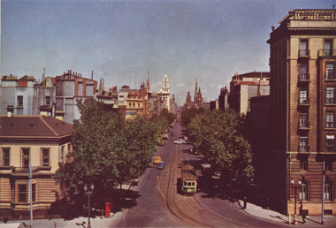 Ballarat Heritage Services
Photograph - Image, Collins Street, Melbourne, from Spring Street, 1951
The Shamrock began life in 1854, as a small hotel known as The Exchange Hotel, servicing miners during the Victorian gold rush/A colour image of Collins Street, Melbourne.melbourne, collins street, streetscape -
 Linton and District Historical Society Inc
Photograph, Linton Pioneer Memorial Cairn in Sussex Street, Linton
A memorial cairn honouring the early pioneers of Linton was erected in Sussex Street in 1939.A sepia photograph of Linton pioneer memorial cairn in Sussex Street, old blacksmith's shop (Ball's) in background, also Mrs Blamire's home.On back -"Linton pioneer memorial cairn. There used to be a row of huge gum trees along excavation for memorial. Old blacksmiths shop in background, also Mrs Blamire's home. Mrs McCorkill's house must have been brought in."sussex street, memorials, blamire, blacksmith's shop -
 Eltham District Historical Society Inc
Photograph, First house in Pryor Street, Eltham, c.1965, 1965c
This was the first house on Pryor Street which was located at the corner of what is now Commercial Place on the eastern side. Originally there was another house adjacent but it had been moved by the time of the 1951 aerial survey. The house was also the first home of Russell Yeoman who had been newly appointed to the Shire of Eltham and this house belonging to the council was vacant and made available to him for four weeks before it was relocated to Susan Street just south of the bowls club and was used a child care centre associated with the Living and Learning Centre (Russell believes). Russell then moved into another council owned house at the corner of Susan and Bridge Streets.Digital file only; created from original colour positive slide transparencyeltham, streets, houses, pryor street, susan street, fe holden sedan, russell yeoman collection -
 Eltham District Historical Society Inc
Photograph, First house in Pryor Street, Eltham, c.1965, 1965c
This was the first house on Pryor Street which was located at the corner of what is now Commercial Place on the eastern side. Originally there was another house adjacent but it had been moved by the time of the 1951 aerial survey. The house was also the first home of Russell Yeoman who had been newly appointed to the Shire of Eltham and this house belonging to the council was vacant and made available to him for four weeks before it was relocated to Susan Street just south of the bowls club and was used a child care centre associated with the Living and Learning Centre (Russell believes). Russell then moved into another council owned house at the corner of Susan and Bridge Streets.Digital file only; created from original colour positive slide transparencyeltham, streets, houses, pryor street, susan street, russell yeoman collection, fc holden sedan -
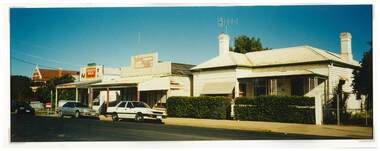
 Kilmore Historical Society
Photograph, 39 Sydney Street, 1980's?
Was the site of the Old Colonial Bank of Australasia Ltd.9.5cm x 10cm coloured photograph of the building at 39 Sydney Street. The double story building has an ornate light-coloured facade, which darker brickwork on the sides. Arched windows on the ground floor and rectangle window with trim on the top floor. Signage on the building states "Dornal Antiques". There is also a planter out the front on the footpath.storefront, shopfront, antiques, antique dealers, retail stores -
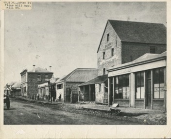 Kilmore Historical Society
Photograph, SW Sydeny Street, 1860
25cm x 20 cm black and white photograph mounted on board. The photograph is taken at an angle so you can see multiple buildings on the western side of Sydney Street including: Trainor's Steam Flour Mill, Parnells Boot Shop, Quinn Solicitor, Youngs Bakery and Post Office and Royal Oak Hotel in the distance.Written on the back: #10 Trainor's Steam Flour Mill, Parnell's Bootshop, Quinn Solicitor, Young's Bakery + Post Office #3.#5.10/86-38A Copy of Sydney St. Kilmore 1860 Trainors Mill (opposite present Mill St) Royal Oak Hotel in distance.post office, flour mill, bakery, bootmaker -
 Tatura Irrigation & Wartime Camps Museum
Photograph, Tom Flanagan's House, Hogan Street Tatura
Shows Tom Flanagan's house in Hogan Street looking east along Hogan Street. Shows Dave and Grace Howarth's Milk Bar. Colour photograph showing Tom Flanagan's house in Hogan Street, Tatura, looking east towardsDave and Grace Howarth's Milk Bar. Photograph stuck onto piece of white cardboard. hogan street tatura, tatura businesses, ross street tatura, tom flanagan, grace howarth, dave howarth, howarth milk bar tatura