Showing 1317 items
matching victorian maps
-
 Kew Historical Society Inc
Journal, Kew Historical Society, Newsletter No.112, September 2015
Historic Maps of Kew / Robert Baker p1. Exhibitions p3. Quarterly Book Sales p3. Meetings & Lectures p3. New Members p3. For Whom the Bell Tolls / Suzanne McWha p4. Tuesday Volunteers p5. The Red Menace / Robert Baker p6. Philip Slobom p7. Daily Life in Kew: The Summer of 1885/86 / Andrew Frost p8. Recent Acquisitions / Robert Baker p10. Annual General Meeting / Tony Michael p10. Form of Appointment of Proxy p11. Nomination Form p11. Membership & Donations p12.Published quarterly since 1977, the newsletters of the Kew Historical Society contain significant research by members that explore aspects of the Victorian and Australian Framework of Historical Themes. Frequently, articles on people, places and artefacts are the only source of information about an aspect of Kew, and Melbourne’s history.non-fictionHistoric Maps of Kew / Robert Baker p1. Exhibitions p3. Quarterly Book Sales p3. Meetings & Lectures p3. New Members p3. For Whom the Bell Tolls / Suzanne McWha p4. Tuesday Volunteers p5. The Red Menace / Robert Baker p6. Philip Slobom p7. Daily Life in Kew: The Summer of 1885/86 / Andrew Frost p8. Recent Acquisitions / Robert Baker p10. Annual General Meeting / Tony Michael p10. Form of Appointment of Proxy p11. Nomination Form p11. Membership & Donations p12.kew historical society (vic.) -- periodicals., kew historical society (vic.) -- newsletters, kew historical society (vic.) -- journals -
 Kew Historical Society Inc
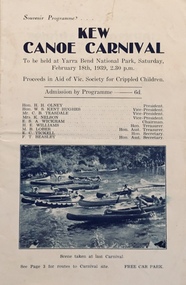
Programme, Kew Canoe Carnival, 1939
An item from an outstanding and diverse photographic collection, assembled by members of the Christian and Washfold families of Kew.10-page souvenir programme for the Kew Canoe Carnival to be held at Yarra Bend National Park on Saturday February 18th, 1939. Proceeds were designed to assist the Victorian Society for Crippled Children. Front cover shows photograph taken at the previous year's carnival. The site of the carnival shown on an internal map was upriver from Macauley's boat house. Photograph on back cover shows canoeists at Kew Boat Sheds, 45 Molesworth Street.kew canoe carnivals, recreation -- river yarra, christian-washfold collection -
 Kew Historical Society Inc
Map, MMBW, MMBW Town of Kew, 1910-21
The Melbourne and Metropolitan Board of Works (MMBW) was established by an act of the Victorian Parliament in 1890 to prepare for and to implement a sewerage and water reticulation system across what was then inner Melbourne, its surrounding and middle distance suburbs, including Kew. The MMBW was disbanded in 1991.The map collection of the Kew Historical Society has at its core the historic maps assembled and originally stored in the City Engineer's Department of the City of Kew. These include maps in a number of scales. The vast majority of maps were produced by the MMBW in the first two decades of the twentieth century, and are solid working maps, backed by linen for durability. These maps are historically significant to Kew, the City of Boroondara and to the history of the development of state utilities in Victoria. A number of the Kew maps have additional details added by former municipal officers, including the levels reached by various floods. As these were working documents, information was added to them long after the period of their initial production and distribution.Early map of the Town of Kew, created after 1910, at a scale 440 ft to 1 inch. The 'assembled' map by the City of Kew Engineer's Department includes scaled down copies of The Melbourne and Metropolitan Board of Works maps, Nos. 39, 40, 64, 65, 66, 67, 68, and 117. The map covers the entirety of the Town of Kew, bordered on its north and west by the River Yarra, by Burke Road in the East and Barkers Road in the south. The map shows the extent of urban development by that time, prominent institutions and the outlines of built structures in the municipality. TOWN OF KEW / SCALE 400 FEET TO 1 INCHmelbourne & metropolitan board of works, mmbw maps, mmbw plans, town of kew, cartography -
 Kew Historical Society Inc
Map, MMBW, MMBW Plan No.39 Kew & Heidelberg, 1900-1910
The Melbourne and Metropolitan Board of Works (MMBW) was established by an act of the Victorian Parliament in 1890 to prepare for and to implement a sewerage and water reticulation system across what was then inner Melbourne, its surrounding and middle distance suburbs, including Kew. The MMBW was disbanded in 1991.The map collection of the Kew Historical Society has at its core the historic maps assembled and originally stored in the City Engineer's Department of the City of Kew. These include maps in a number of scales. The vast majority of maps were produced by the MMBW in the first two decades of the twentieth century, and are solid working maps, backed by linen for durability. These maps are historically significant to Kew, the City of Boroondara and to the history of the development of state utilities in Victoria. A number of the Kew maps have additional details added by former municipal officers, including the levels reached by various floods. As these were working documents, information was added to them long after the period of their initial production and distribution.Early map of part of the Borough of Kew, created in the first decade of the twentieth century, at a scale 160 ft to 1 inch. The map covers what was then the north western section of Kew, bordered on its north by Wills Street and the Kew Lunatic Asylum, in the west by the River Yarra [and the later added Yarra Boulevard] , by Princess Street in the East and Holroyd Street in the south. The map shows the extent of urban development by that time, prominent institutions and the outlines of built structures in the municipality. Contour lines were added in ink to the map at a later stage.MELBOURNE AND METROPOLITAN BOARD OF WORKS / PLAN NO. 39 / KEW & HEIDELBERGmelbourne & metropolitan board of works, mmbw maps, mmbw plans, borough of kew, cartography -
 Kew Historical Society Inc
Map, MMBW, MMBW Plan No.40 Collingwood & Kew, 1900-1910
The Melbourne and Metropolitan Board of Works (MMBW) was established by an act of the Victorian Parliament in 1890 to prepare for and to implement a sewerage and water reticulation system across what was then inner Melbourne, its surrounding and middle distance suburbs, including Kew. The MMBW was disbanded in 1991.The map collection of the Kew Historical Society has at its core the historic maps assembled and originally stored in the City Engineer's Department of the City of Kew. These include maps in a number of scales. The vast majority of maps were produced by the MMBW in the first two decades of the twentieth century, and are solid working maps, backed by linen for durability. These maps are historically significant to Kew, the City of Boroondara and to the history of the development of state utilities in Victoria. A number of the Kew maps have additional details added by former municipal officers, including the levels reached by various floods. As these were working documents, information was added to them long after the period of their initial production and distribution.Early map of part of the Borough of Kew, created in the first decade of the twentieth century, at a scale 160 ft to 1 inch. The map covers what was then the south western section of Kew, bordered on its north by Studley Park Road, in the west by Walmer Street and the River Yarra, by High Street South and Princess Street in the East and Barkers Road in the south. The map shows the extent of urban development by that time, prominent institutions and the outlines of built structures in the municipality. Contour lines and historic flood levels were added in ink to the map at a later stage.MELBOURNE AND METROPOLITAN BOARD OF WORKS / PLAN NO. 40 / COLLINGWOOD & KEWmelbourne & metropolitan board of works, mmbw maps, mmbw plans, borough of kew, cartography -
 Kew Historical Society Inc
Map, MMBW, MMBW Plan No.64 Kew & Heidelberg, 1900-1910
The Melbourne and Metropolitan Board of Works (MMBW) was established by an act of the Victorian Parliament in 1890 to prepare for and to implement a sewerage and water reticulation system across what was then inner Melbourne, its surrounding and middle distance suburbs, including Kew. The MMBW was disbanded in 1991.The map collection of the Kew Historical Society has at its core the historic maps assembled and originally stored in the City Engineer's Department of the City of Kew. These include maps in a number of scales. The vast majority of maps were produced by the MMBW in the first two decades of the twentieth century, and are solid working maps, backed by linen for durability. These maps are historically significant to Kew, the City of Boroondara and to the history of the development of state utilities in Victoria. A number of the Kew maps have additional details added by former municipal officers, including the levels reached by various floods. As these were working documents, information was added to them long after the period of their initial production and distribution.Early map of part of the Borough of Kew, created in the first decade of the twentieth century, at a scale 160 ft to 1 inch. The map covers what was then the northern most part of Kew, bordered on its north and west by the Yarra River, in the East by Connor's Creek and by the Asylum in the south. The map shows the extent of urban development by that time, prominent institutions and the outlines of built structures in the municipality. Contour lines and historic flood levels were added in ink to the map at a later stage.MELBOURNE AND METROPOLITAN BOARD OF WORKS / PLAN NO. 64 / KEW & HEIDELBERGmelbourne & metropolitan board of works, mmbw maps, mmbw plans, borough of kew, cartography -
 Kew Historical Society Inc
Map, MMBW, MMBW Plan No.65 Kew & Heidelberg, 1900-1910
The Melbourne and Metropolitan Board of Works (MMBW) was established by an act of the Victorian Parliament in 1890 to prepare for and to implement a sewerage and water reticulation system across what was then inner Melbourne, its surrounding and middle distance suburbs, including Kew. The MMBW was disbanded in 1991.The map collection of the Kew Historical Society has at its core the historic maps assembled and originally stored in the City Engineer's Department of the City of Kew. These include maps in a number of scales. The vast majority of maps were produced by the MMBW in the first two decades of the twentieth century, and are solid working maps, backed by linen for durability. These maps are historically significant to Kew, the City of Boroondara and to the history of the development of state utilities in Victoria. A number of the Kew maps have additional details added by former municipal officers, including the levels reached by various floods. As these were working documents, information was added to them long after the period of their initial production and distribution.Early map of part of the Borough of Kew, created in the first decade of the twentieth century, at a scale 160 ft to 1 inch. The map covers what was then the south central part of Kew, bordered on its north by Malmsbury Street, in the west by Florence Avenue, in the south by Barkers Road, and in the east by Princess Street. The map shows the extent of urban development by that time, prominent institutions and the outlines of built structures in the municipality. Contour lines were added in ink to the map at a later stage.MELBOURNE AND METROPOLITAN BOARD OF WORKS / PLAN NO. 65 / KEW & HEIDELBERGmelbourne & metropolitan board of works, mmbw maps, mmbw plans, borough of kew, cartography -
 Kew Historical Society Inc
Map, MMBW, MMBW Plan No.66 Kew, 1900-1910
The Melbourne and Metropolitan Board of Works (MMBW) was established by an act of the Victorian Parliament in 1890 to prepare for and to implement a sewerage and water reticulation system across what was then inner Melbourne, its surrounding and middle distance suburbs, including Kew. The MMBW was disbanded in 1991.The map collection of the Kew Historical Society has at its core the historic maps assembled and originally stored in the City Engineer's Department of the City of Kew. These include maps in a number of scales. The vast majority of maps were produced by the MMBW in the first two decades of the twentieth century, and are solid working maps, backed by linen for durability. These maps are historically significant to Kew, the City of Boroondara and to the history of the development of state utilities in Victoria. A number of the Kew maps have additional details added by former municipal officers, including the levels reached by various floods. As these were working documents, information was added to them long after the period of their initial production and distribution.Early map of part of the Borough of Kew, created in the first decade of the twentieth century, at a scale 160 ft to 1 inch. The map covers what was then the south eastern part of Kew, bordered on its north by Adeney Avenue, in the west by Sackville Street, in the south by Barkers Road, and in the east by Burke Road. The map shows the extent of urban development by that time, prominent institutions and the outlines of built structures in the municipality. Contour lines were added in ink to the map at a later stage.MELBOURNE AND METROPOLITAN BOARD OF WORKS / PLAN NO. 66 / KEW melbourne & metropolitan board of works, mmbw maps, mmbw plans, borough of kew, cartography -
 Kew Historical Society Inc
Map, MMBW, MMBW Plan No.67 Kew, 1900-1910
The Melbourne and Metropolitan Board of Works (MMBW) was established by an act of the Victorian Parliament in 1890 to prepare for and to implement a sewerage and water reticulation system across what was then inner Melbourne, its surrounding and middle distance suburbs, including Kew. The MMBW was disbanded in 1991.The map collection of the Kew Historical Society has at its core the historic maps assembled and originally stored in the City Engineer's Department of the City of Kew. These include maps in a number of scales. The vast majority of maps were produced by the MMBW in the first two decades of the twentieth century, and are solid working maps, backed by linen for durability. These maps are historically significant to Kew, the City of Boroondara and to the history of the development of state utilities in Victoria. A number of the Kew maps have additional details added by former municipal officers, including the levels reached by various floods. As these were working documents, information was added to them long after the period of their initial production and distribution.Early map of part of the Borough of Kew, created in the first decade of the twentieth century, at a scale 160 ft to 1 inch. The map covers what was then the north central part of Kew, bordered on its north by the Outer Circle Railway Spruzen and Beresford Avenues, in the west by Princess Street, in the south by High Street, and in the east by (about) Belford Road. The map shows the extent of urban development by that time, prominent institutions and the outlines of built structures in the municipality. Contour lines were added in ink to the map at a later stage.MELBOURNE AND METROPOLITAN BOARD OF WORKS / PLAN NO. 67 / KEW melbourne & metropolitan board of works, mmbw maps, mmbw plans, borough of kew, cartography -
 Kew Historical Society Inc
Map, MMBW, MMBW Plan No.68 Kew, 1900-1910
The Melbourne and Metropolitan Board of Works (MMBW) was established by an act of the Victorian Parliament in 1890 to prepare for and to implement a sewerage and water reticulation system across what was then inner Melbourne, its surrounding and middle distance suburbs, including Kew. The MMBW was disbanded in 1991.The map collection of the Kew Historical Society has at its core the historic maps assembled and originally stored in the City Engineer's Department of the City of Kew. These include maps in a number of scales. The vast majority of maps were produced by the MMBW in the first two decades of the twentieth century, and are solid working maps, backed by linen for durability. These maps are historically significant to Kew, the City of Boroondara and to the history of the development of state utilities in Victoria. A number of the Kew maps have additional details added by former municipal officers, including the levels reached by various floods. As these were working documents, information was added to them long after the period of their initial production and distribution.Early map of part of the Borough of Kew, created in the first decade of the twentieth century, at a scale 160 ft to 1 inch. The map covers what was then the north central part of Kew, bordered in the north by Oak Avenue, in the west by the Yarra River and Connor's Creek, in the south by Beresford and Carnegie Avenues, and in the east by Glass's Creek and Burke Road. The map shows the extent of urban development by that time, prominent institutions and the outlines of built structures in the municipality. Contour lines and the levels of historic floods were added in ink to the map at a later stage.MELBOURNE AND METROPOLITAN BOARD OF WORKS / PLAN NO. 68 / KEW melbourne & metropolitan board of works, mmbw maps, mmbw plans, borough of kew, cartography -
 Kew Historical Society Inc
Map, MMBW, MMBW Plan No.117 Heidelberg & Kew, 1900-1910
The Melbourne and Metropolitan Board of Works (MMBW) was established by an act of the Victorian Parliament in 1890 to prepare for and to implement a sewerage and water reticulation system across what was then inner Melbourne, its surrounding and middle distance suburbs, including Kew. The MMBW was disbanded in 1991.The map collection of the Kew Historical Society has at its core the historic maps assembled and originally stored in the City Engineer's Department of the City of Kew. These include maps in a number of scales. The vast majority of maps were produced by the MMBW in the first two decades of the twentieth century, and are solid working maps, backed by linen for durability. These maps are historically significant to Kew, the City of Boroondara and to the history of the development of state utilities in Victoria. A number of the Kew maps have additional details added by former municipal officers, including the levels reached by various floods. As these were working documents, information was added to them long after the period of their initial production and distribution.Early map of part of the Borough of Kew, created in the early twentieth century, at a scale 160 ft to 1 inch. The map covers what was then the north eastern part of Kew showing the natural landscape and limited development on the south side of the Yarra River. In the Kew section, south of the river, the land is occupied currently by the Greenacres and Kew Golf Clubs. The map shows the extent of urban development by that time and the outlines of the few built structures in the municipality. The height above sea level of all parts of the landscape are indicated numerically in feet. Contour lines and the levels of historic floods were added in ink to the map at a later stage. MELBOURNE AND METROPOLITAN BOARD OF WORKS / PLAN NO. 117 / HEIDELBERG & KEW melbourne & metropolitan board of works, mmbw maps, borough of kew, cartography, mmbw plan no. 117, kew (vic.) -- maps, heidelberg (vic.) -- maps -
 Kew Historical Society Inc
Map, MMBW, River Yarra Beautification Schemes, c.1913
The Melbourne and Metropolitan Board of Works (MMBW) was established by an act of the Victorian Parliament in 1890 to prepare for and to implement a sewerage and water reticulation system across what was then inner Melbourne, its surrounding and middle distance suburbs, including Kew. The MMBW was disbanded in 1991.The map collection of the Kew Historical Society has at its core the historic maps assembled and originally stored in the City Engineer's Department of the City of Kew. These include maps in a number of scales. The vast majority of maps were produced by the MMBW in the first two decades of the twentieth century, and are solid working maps, backed by linen for durability. These maps are historically significant to Kew, the City of Boroondara and to the history of the development of state utilities in Victoria. A number of the Kew maps have additional details added by former municipal officers, including the levels reached by various floods. As these were working documents, information was added to them long after the period of their initial production and distribution.Map of the City of Kew showing part of the River Yarra Beautification Schemes. The map shows development to date and the flood levels reached in 1923 and 1924. This map may have been adapted from an earlier map, as most development in central Kew and Studley Park had occurred by this date yet numerous streets are not represented. Public buildings and institutions are clearly represented and named on the map as are significant public transport infrastructure (eg the Outer Circle railway).MELBOURNE AND METROPOLITAN BOARD OF WORKS / RIVER YARRA BEAUTIFICATION SCHEMES / SCHEME / SCALE 10 CHAINS TO AN INCHmelbourne & metropolitan board of works, mmbw maps, mmbw plans, city of kew, flood levels -- kew (vic.), cartography -
Kew Historical Society Inc
Book, Powerline Review Panel, Final Report to the Victorian Government, 1989
Final Report to the Victorian Government of the Powerline Review, 1989264 p. in various pagings : ill., maps ; 30 cm.non-fictionFinal Report to the Victorian Government of the Powerline Review, 1989electric power distribution -- victoria -- brunswick, electric power distribution -- victoria -- richmond -
Kew Historical Society Inc
Book, Kew Municipal Library, Kew Births 1849-1870, 1994
Kew births 1849-1870 : records extracted from the Victorian pioneers index under the district names of Kew, Cotham and Studley ParkKew, Vic. : Kew Library, 1994. 1 vol. ; 30cm.non-fictionKew births 1849-1870 : records extracted from the Victorian pioneers index under the district names of Kew, Cotham and Studley Parkbirths - deaths - marriages -- kew (vic.) 1849-1870 -
 Bendigo Tramways (managed by the Bendigo Heritage Attractions)
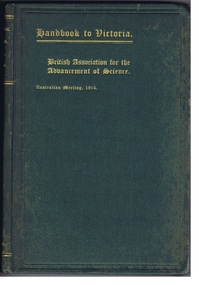
Reference Book, Albert J. Mullett, Government Printer, Melbourne, Handbook to Victoria- British Association for the Advancement of Science, CIRCA 1914
1914 Handbook prepared for the members of the "British Association for the advancement of science" on the occasion of their visit to Victoria, under the direction of the Victorian Executive Committee. Hard covered green handbook, gold leaf lettering. Printed text with Illustrations, Maps, Plans and Diagrams.Stamped: "WITH THE COMPLEMENTS OF THE GOVERNMENT STATIST." victoria, 1914, education, population, immigration, mining, geology, land, law, government, forestry, maps, public works. -
 8th/13th Victorian Mounted Rifles Regimental Collection
Document
In 1988, as part of a Defence of Mainland Australian policy, defence of facilities of strategic importance in northern Australia were allocated to Army Reserve units. ‘A’ Squadron was allocated the defence of Tindal Air Force base located 15 KM outside Katherine in Northern Territory. Consequently the Squadron deployed on Exercise ‘Northern Explorer’ to gain first-hand knowledge of operating conditions for mounted and dismounted patrolling in the area.Rare example of a patrol report conducted by soldiers of a Victorian Army Reserve regiment while exercising in Northern Territory.Report of reconnaissance patrol conducted by soldiers of 'A' Squadron 8/13 Victorian Mounted Rifles during Exercise 'Northern Explorer, Northern Territory. 13 pages plus sketch map. -
 8th/13th Victorian Mounted Rifles Regimental Collection
Document - Report
In 1988, as part of a Defence of Mainland Australian policy, defence of facilities of strategic importance in northern Australia were allocated to Army Reserve units. ‘A’ Squadron was allocated the defence of Tindal Air Force base located 15 KM outside Katherine in Northern Territory. Consequently the Squadron deployed on Exercise ‘Northern Explorer’ to gain first-hand knowledge of operating conditions for mounted and dismounted patrolling in the area.Rare patrol report made by soldiers of a Victorian regiment while on exercise in Northern Territory.Report of patrol carried out by soldiers of 'A' Squadron 8/13 Victorian Mounted Rifles 18 September 1988 near Tindal Air Base Northern Territory. Six pages plus sketch map.military, patrol, tindal, northern territory, vmr -
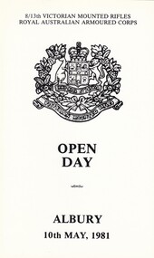 8th/13th Victorian Mounted Rifles Regimental Collection
Document
The 8th/13th Victorian Mounted Rifles was raised as a regiment of the Royal Australian Armoured Corps on 1 May 1948 with Headquarters in Melbourne and squadrons in Sale, Benalla/Wangaratta and Albury. In 1955 Regimental Headquarters moved to Wangaratta and a second squadron was located at Albury. The Sale squadron transferred to 4th/19th Prince of Wales’s Light Horse. In 1977 8/13 VMR Regiment was reduced to an independent squadron A Squadron 8th/13th Victorian Mounted Rifles and in 1991 was linked with 4th/19th Prince of Wales’s Light Horse forming the VMR Squadron of that regiment.Black and white single fold card being program for Regimental Open Day at Buna Barrack Albury, 10 May 1981. Contains brief history of Regiment, program for day and map of Buna Barracks. -
 Surrey Hills Historical Society Collection
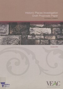
Book, Historic Places Investigation Draft Proposals Paper, 2015
Draft Proposals paper for Victorian Environmental Assessment Council's (VEAC) Historic Places investigation, written for community consultation purposes.Draft Proposals paper for Victorian Environmental Assessment Council's (VEAC) Historic Places investigation, written for community consultation purposes. colour illus. mapshistory buildings, historic sites, public lands -
 Federation University Art Collection
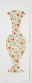
Artwork, other - Handcut & Collaged maps on paper, 'Survey Vessel I' by Carole Wilson, 2008
Carole WILSON (1960- ) Born Canberra, Australia Carole Wilson undertook undergraduate studies at the Canberra School of Arts and Phillip Institute of Technology. She completed a Graduate Diploma in Education at the University of Ballarat in 1987, and a Doctor of Philosophy in 2000. She has chosen central motifs in her work, which she incorporates throughout a series. The urn has been a unifying motif in Wilson's map work and testifies to the way in which function drives form across cultures. Carole's work is held in many public collections including the National Gallery of Australia, the Powerhouse Museum, State Library of Victoria and a number of regional Victorian galleries. Her posters are in museum collections in Finland, Moscow and Poland. In 2001 Dr Wilson was awarded a Doctor of Philosophy (Visual Art) from the University of Ballarat (Now Federation University). She graduated with a Graduate Diploma in Education from University of Ballarat in 1987, and a Diploma of Art from the Phillip Institute of Technology (RMIT) in 1984. Carole Wilson lectures at Federation University Australia: 2010- Senior Lecturer in Visual Arts, Honours and Research Degrees Co-ordinator 2009-2011 Lecturer in Studio Practice and Postgraduate Co-ordinator 1999-2008 Lecturer in Visual Arts (Sessional) This item is part of the Federation University Art Collection. The Art Collection features over 2000 works and was listed as a 'Ballarat Treasure' in 2007. Donated through the Australian Government's Cultural Gifts Program by Anne M. Drum, 2011art, artwork, carole wilson, maps, urn, alumni, available, staffmember -
 Federation University Art Collection
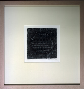
Print, 'Collagraph 3' by Carole Wilson, 2007
Carole WILSON (1960- ) Born Canberra, Australia Carole Wilson undertook undergraduate studies at the Canberra School of Arts and Phillip Institute of Technology. She completed a Graduate Diploma in Education at the University of Ballarat in 1987, and a Doctor of Philosophy in 2000. She has chosen central motifs in her work, which she incorporates throughout a series. The urn has been a unifying motif in Wilson's map work and testifies to the way in which function drives form across cultures. Carole's work is held in many public collections including the National Gallery of Australia, the Powerhouse Museum, State Library of Victoria and a number of regional Victorian galleries. Her posters are in museum collections in Finland, Moscow and Poland. In 2001 Dr Wilson was awarded a Doctor of Philosophy (Visual Art) from the University of Ballarat (Now Federation University). She graduated with a Graduate Diploma in Education from University of Ballarat in 1987, and a Diploma of Art from the Phillip Institute of Technology (RMIT) in 1984. Carole Wilson lectures at Federation University Australia: 2010- Senior Lecturer in Visual Arts, Honours and Research Degrees Co-ordinator 2009-2011 Lecturer in Studio Practice and Postgraduate Co-ordinator 1999-2008 Lecturer in Visual Arts (Sessional) This item is part of the Federation University Art Collection. The Art Collection features over 2000 works and was listed as a 'Ballarat Treasure' in 2007. Carole Wilson lectures at Federation University Australia: Framed collograph by Carole Wilson. art, artwork, wilson, carole wilson, available -
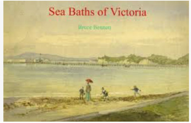 Port Fairy Historical Society Museum and Archives
Book, Bennett, Bruce, Sea Baths of Victoria, 2013
This is the story of the sea baths in Victoria from earliest settlement in 1837. Their development and growth followed the prosperity of Victorian society for nearly a hundred years.152 pages : illustrations (some colour), maps ; 22 x 31 cm. Includes bibliographical references (pages 146-150) and index.This is the story of the sea baths in Victoria from earliest settlement in 1837. Their development and growth followed the prosperity of Victorian society for nearly a hundred years.baths, sea -- history., bathing beaches -- australia -- victoria -- history., public baths -- australia -- victoria -- history., public baths., sea., bathing beaches -- australia., public baths -- victoria -- 19th century., public baths -- victoria -- 20th century., sea -- australia -- victoria -- history., book -
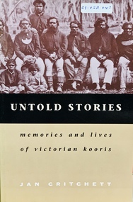 Port Fairy Historical Society Museum and Archives
Book, Melbourne University Press, Untold stories : memories and lives of Victorian Kooris, 1998
'I'm your half-brother and I'm here to stay. This is my home.' With these words Wilmot Abraham sought refuge with his white relations. 'Did you ever read your history?': Mrs. Mary Clarke remembers p. 1 'An old hand': Jim Cain p. 12 'I'm your half-brother, and I'm here to stay': Wilmot Abraham p. 36 The Three Pompeys The Written Record p. 48 Banjo Clarke's Stories p. 62 'Why did they take them away?': Lizzie and Henry McCrae p. 74 In Defence of Framlingham: Collin Hood p. 79 Double Dispossession: King David p. 107 James Dawson's Informants p. 137 'Why are we kept prisoners here?': Ernest and Maggie Mobourne p. 148 'The old ones, they wouldn't tell us nothing': Mrs. Connie Hart's memories p. 181 'Breaking the cycle is the hard thing to do': Geoff Rose, a stolen child p. 200 Epilogue: James Dawson, Camperdown George and the Obelisk p. 220 The Hood Family p. 238 The Mobourne Letters p. 241 Abbreviations p. 252 Notes p. 252 Bibliography p. 264 Index p. 274xxi, 283 p. : ill., facsims., map, ports. ; 23 cm. Includes index and bibliographical references: p. 264-273.non-fiction'I'm your half-brother and I'm here to stay. This is my home.' With these words Wilmot Abraham sought refuge with his white relations. 'Did you ever read your history?': Mrs. Mary Clarke remembers p. 1 'An old hand': Jim Cain p. 12 'I'm your half-brother, and I'm here to stay': Wilmot Abraham p. 36 The Three Pompeys The Written Record p. 48 Banjo Clarke's Stories p. 62 'Why did they take them away?': Lizzie and Henry McCrae p. 74 In Defence of Framlingham: Collin Hood p. 79 Double Dispossession: King David p. 107 James Dawson's Informants p. 137 'Why are we kept prisoners here?': Ernest and Maggie Mobourne p. 148 'The old ones, they wouldn't tell us nothing': Mrs. Connie Hart's memories p. 181 'Breaking the cycle is the hard thing to do': Geoff Rose, a stolen child p. 200 Epilogue: James Dawson, Camperdown George and the Obelisk p. 220 The Hood Family p. 238 The Mobourne Letters p. 241 Abbreviations p. 252 Notes p. 252 Bibliography p. 264 Index p. 274 western district (vic.) -- colonization., aboriginal australians -- victoria -- western district -- history., aboriginal australians -- victoria -- western district -- interviews, race relations - racial discrimination., child welfare - child / parent separation - stolen generations., history - biographies - indigenous., book -
Vision Australia
Administrative record (Series), Victorian Association of Braille Writers, 1895-1961
Victorian Association of Braille Writers, 31-51 Commercial Road, South Yarra, Victoria 3141To provide information on general information on work undertaken, financial position, income and cash flow.Single volumes created annually from 1895 until 1961.Minutes of AGM, Annual Report of Directors, President's Report, financial informationcorporation records, victorian association of braille writerscorporation records, victorian association of braille writers -
Vision Australia
Administrative record (Series), Royal Victorian Insitute for the Blind Annual Reports, 1892
Royal Victorian Institute for the Blind, 557-563 St Kilda Road, Melbourne, 3000.To provide information on general information on work undertaken, financial position, income and cash flow.Single volumes created annually from 1892 until 2004.President's Report, Finance Report, General Overview of Services.corporation records, royal victorian institute for the blindcorporation records, royal victorian institute for the blind -
 Vision Australia
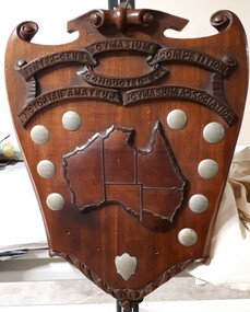
Photograph - Image, Inter-Club Gymnasium Competition
The Conder Shield was sponsored by Major Wally Conder, a keen sportsman (amongst other occupations,) who sought to promote wrestling and boxing during his time as president of the Victorian Amateur Wrestling and Boxing Association. Presented to the winning club of the Inter-Club Gymnasium Competition, over a series of matches in individual athleticism. These included skipping, roller cycling and chinning bar, as well as light-weight, middle-weight and welter-weight wrestling. The clubs that vied for this shield were the Trojans (from the RVIB), Bonbeach Surf and Life Saving Club and Beattie's Physical Culture School. In 1934, the Trojans team consisted of Neil Westh, Charlie Bradley, A. McDonald, T. Hanlon, B. Cook and coach/captain V. Blucher. Mr Henry Vincent Blucher was a former police constable to lost his sight in 1931 due to a car accident, and who had previously held the title of Victorian novice middleweight. Metal plates on shield read: V.A.G.A. Inter-club gym contest 1933-34 Won by "Trojans" B.P.C.C. V.A.G.A. Inter-club gym contest 1935 Won by V.R.I. Gym Club Won by "Trojans" 1936 Won by "Trojans" 1937 Runners Up Bonbeach 1934 Runners Up Trojans 1935 Runners Up "Achilles" 1936 Runners Up "Achilles" 1937 Achilles Runners Up 1938 Presented by W.T. ConderImage of wooden shield with metal plaques and map of AustraliaInter-Club Gymnasium Competition conducted by Victorian Amateur Gymnasium Associationrecreation, royal victorian institute for the blind, awards -
 Vision Australia
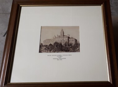
Photograph - Image, Charles Nettleton, Blind Asylum School, St Kilda Road, circa 1875
Unsubstantiated photograph of the Asylum for the Blind in 1875. The four storey bluestone building rises above a group of trees planted in the garden. A picket and wire/string fence border the unpaved circular driveway. 2 black and white images of the Guiding Light at Elanora Blind Asylum School, St Kilda Road Victoria c. 1875 Charles Nettleton 1826-1902 Spencer Scott Sandilands 546 High Street, East Preson, 3181 Melbourne, Victoria, Australia, Tel: (03) 529 8011 Fax: (03) 521 1754 33 George Street, The Rocks, 2000 Sydney, New South Wales, Australia, Tel: (02) 241 4251 Fax: (02) 2414535 Rare Prints, Antiquarian Books, Old Maps, Australiana, Antiques, Photographs, Framing c.1875 Charles Nettleton School from the Blind Original Photograph $65 Guaranteed over 100 years oldroyal victorian institute for the blind, buildings -
 Falls Creek Historical Society
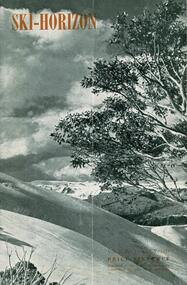
Journal - Ski-Horizon Vol. 2 No 11
Ski-Horizon is the official journal of the Federation of Victorian Ski Clubs which began publication in 1949. The were 26 original member clubs which included Albury Ski Club, Bogong Ski Club, Myrtleford Ski Club, Tallangatta and District Ski Club and Wangaratta Ski Club. Two pioneers of Falls Creek, Tom Mitchell, M.L.A., and Martin Romuld were Vice-Presidents of the Federation.This Journal is significant because it documents the early development of skiing in Victoria.The journal features stories and events chronicling developments in Victoria and internationally. Items related to the Falls Creek Area in this publication include:- Page 2: Reference to ski instructors and Ski Schools in Victoria including Bob Hymans' School and Ernst and Auriel Forras who operate the Nussen School with Max Denham. Page 5 Bogong High Plains locality map, with construction areas and power lines marked. It is accompanied by a notice regarding safety and access from H. H. C.Williams, Construction Engineer. Page 12 An article referring to Tom Mitchell's stallion "Debtor" and Ernest Forras, Ski Instructor. Page 13: Continuation of Ernest Forras' profile. Page 22 Comment by Toni St. Elmo and the Myrtleford Ski Club Tow. ski history victoria, federation of victorian ski clubs, ernest forras, nissen ski school -
Friends of Ballarat Botanical Gardens History Group
Work on paper - Victoria Park Precinct, City of Ballarat, Victorian Heritage Database place details -19/9/2017, 19/9/2017
Victoria Park is associated with gold mining in the 1860's, military manoevres in the late 19th century; as an army base during World War 2 and a recreation area.Victoria Park is a "landmark cultural landscape" in the city of Ballarat. This parkland established 1890-1910, was modelled on English country estates and London Parks. It demonstrates the civic pride of Ballarat citizens and is an important parkland for the local community. There is a collection of exotic and early planted native trees and areas of native grasslands.6 pages of print. p.1. is a front page with a map and Victoria Park marked in purple with a bibliography on p.4 and footnotes on p.6.None.john garner, victoria park, friends of ballarat botanical gardens, heritage overlay, gold mining, parkland, late nineteenth century, native grasslands, exotic and native trees, royal park, mullock heap, mount holled-smith, arbor day, messrs clegg&nicholls, william guilfoyle, w.o.allen, significant tree register, john garner collection, gardens, ballarat -
Canterbury History Group
Map - Victorian Railways, Sheet no.10 , Hawthorn to Canterbury, 1/02/1914 12:00:00 AM
... Houses Scott Crescent Victorian Railways Map of Canterbury ...Map of Canterbury Railway Station and its surrounds, includes railway lines and station yards and may houses in nearby streets, February 1914.canterbury, canterbury railway station, canterbury road, maling road, bowling green, canterbury gardens, stationmasters houses, scott crescent, victorian railways