Showing 1471 items matching "view hill"
-
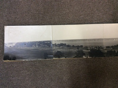 Yarrawonga and Mulwala Pioneer Museum
Photographic Panorama of Mulwala, 1974
Set of four black and white photographs mounted on cardboard when placed sisde by side give a panoramic view of Mulwala and the Lake circa 1974 taken from the factory hill.None -
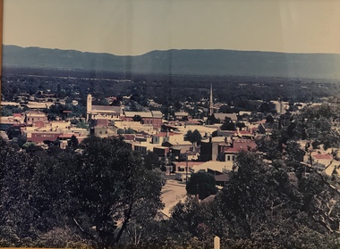 Stawell Historical Society Inc
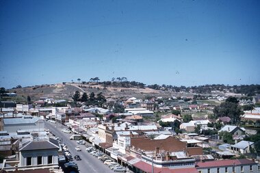
Photograph, Panorama of Stawell from Big Hill -- Coloured
Colour Laminated photograph and timber framed view of Stawell from Big Hill. c 1998 The Town Hall is at the center of photograph and the National Hotel on the left. The back of buildings can be seen at top of Main Street. Laminated and Framed photograph taken by Irene Read in c 1998 showing view of Stawell from Big Hill -- The Coloured photograph can be identified by trees in the foreground, Stawell township and mountains in background.stawell, panorama, streetscape -
 Stawell Historical Society Inc
Photograph, Panorama of Stawell from Big Hill -- Sunset -- Coloured
Sunset from Big Hill. The photo shows the Stawell township with the Grampians in the background and the sun setting behind the Grampians. The majority of the image is a view of the cloud formation. Photo taken by Carol Anne JonesColour photograph of sunset from Big Hill. The photo shows the Stawell township with the sun setting behind the Grampians. The majority of the image is a view of the cloud formation.Carol Anne Jonesstawell -
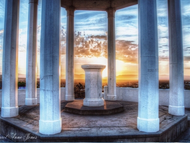 Stawell Historical Society Inc
Photograph, Pioneers Memorial on Big Hill -- Sunset through its Columns -- Coloured
Looking through Pioneers Memorial Columns. The photo shows the ground floor of the Pioneers memorial with the Corinthian pillars supporting the dome. The directional pedestal is in the center installed in c 1947. The Stawell township is in the background with the sun setting behind the Grampians.Looking through Pioneers Memorial Columns with the directional pedestal in the center. The view shows the Stawell township in the background and the sun setting behind the Grampians.Carol Anne Jonesstawell -
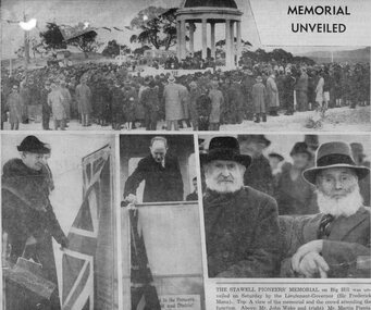 Stawell Historical Society Inc
Newspaper, Sun News Pictorial Reporting on the Stawell Pioneers Memorial 1938
1938 Sun News Pictorial - Stawell Pioneers Memorial on Big Hill Stawell. The top photo is a view of the memorial and the large crowd attending the function. On the left is a photo of the oldest woman who was present on the day Mrs. Phoebe Rebecca Butters. Middle photo is of Lieutenant-Governor Sir Frederic Mann unveiling the foundation stone. The right photo is of Mr. John Wake (right) and Mr. Martin Pianta two old pioneers of the district.August 8th, 1938, Sun News-Pictorial of Stawell Pioneers Memorial unveiled. There are 4 photos depicting the day. Wording on the paper " THE STAWELL PIONEERS' MEMORIAL on Big Hill was unveiled on Saturday by the Lieutenant-Governor (Sir Frederick Mann). Top: A view of the memorial and the crowd attending the function. Above: Mr. John Wake and (right) Mr. Martin Pianta, two old pioneers of the district. On the extreme left is Mrs. P. R. Butters, the oldest woman pioneer who was present. Left: The unveiling ceremony".stawell -
 Stawell Historical Society Inc
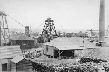
Photograph, Scotchmans United Quartz Mining Company Scene c1890's. Same as 2640
... Stawell Mining Scene from Big Hill. Close up view... Stawell Mining Scene from Big Hill. Close up view of the winding ...Scotchmans United Quartz Mining Company Shaft was 1,018 feet deep.Stawell Mining Scene from Big Hill. Close up view of the winding engine shed Poppet Head and Building Scotchman's United Mine. Rear poppet head Crown Cross. Upper Main Street visible left Back of Photo. Stawell 176 Miles from Melbournemining, panorama -
 Stawell Historical Society Inc
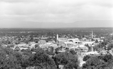
Photograph, View of Stawell from Big Hill
-
 Stawell Historical Society Inc
Map, Stawell Gold Mine, Stawell Gold Mine Photo Map of Stawell Township showing Underground Declines in mining lease, 2007
SGM photo Map 2007 Produced for Public Consultation over Big Hill Open Pit Proposal. Aerial Views Stawellmining, gold, map -
 Stawell Historical Society Inc
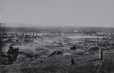
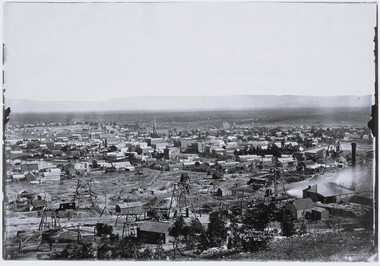
Photograph, View of Stawell from Big Hill April 1874 showing mines centered on St Georges Crushing Mill -- 5 Photos
From left Reefs Restaurant, T. Hogan & Co Tea Wine Spirits Merchant, R. Hepburn Carolina Hotel, Pleasant Creek Hotel, St George Stamping Battery, Free Methodist Chapel Church, Ballarat Hotel, Woodcock Produce Grocer, Stawell Brewery in far distance, L. Thomas Wheelwright Farrier & General Blacksmith, Australian Hotel, G. Laing Bootmaker, Brierly & Wilson Greengrocer, P. Corkeron Bootmaker, P. Corkeron Wholesale Retail General Grocer, Globe Hotel in distance, Christ Church.Part of Holtermann Collection. Black and White photograph of Stawell from Big Hill with mining in foreground. April 1874. View covers from St Patrick's Church to current location of Police Station along Patrick Street. St George Crushing Mill near Centre of Photograph. Includes Carolina Hotelmining, panorama -
 Stawell Historical Society Inc
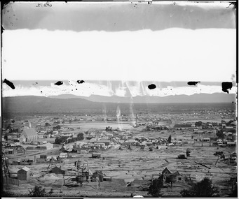
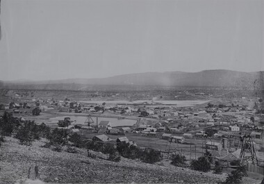
Photograph, View of Stawell from Big Hill 1874 photo showing mines at North end of Stawell -- Looking towards Briggs Bluff -- 2 Photos
Black and White photograph of Stawell from Big Hill with mining in foreground and Moonlight evaporation dams. Holtermann photograph Taken April 1874mining, panorama -
 Stawell Historical Society Inc
Photograph, View of Stawell from Big Hill April 1874 showing mines centered on north end of Main Street -- 2 Photos
From left Shire Hall Pleasant Creek in distance, Mathers & Franklin, Stawell Coach Factory, Coffee Palace, Christ Church of England Church Hill, Mechanics Institute, Temperance Hotel, Matherson Cross Reef Hotel.Black and White Holtermann photograph of Stawell from Big Hill with mining in foreground. 1874 Site of fire in Main and Street Patrick Street 22 April 1874 visible in centre of photograph.mining, panorama, streetscape -
 Stawell Historical Society Inc
Photograph, View of Stawell from Big Hill 1874 showing mines looking towards South end of Black range -- 4 Photos
Visible Nelsons Criterion Hotel, Wimmera Crushing Mill, Odd Fellows Arms hotel, F.H. Oliver & Co Grain Merchant, Reefs Restaurant.Holtermann Black and White photograph of Stawell from Big Hill with mining in foreground. April 1874. Wimmera Crushing Mill and settling pond at centre of photograph. Stawell water supply centre left of photo. Black Range in Background.mining, panorama -
Stawell Historical Society Inc
Map, Stawell Gold Mine, Three dimensional View of Magdala Decline, March 1994
... depth in metres below hill Three dimensional View of Magdala ...View of Mine looking from Stawell Hospital towards Big Hill Levels indicate depth in metres below hillParallel View Scale 1 : 2600mining, gold -
 Stawell Historical Society Inc
Slide, Ian McCann, Main Street Toward Big Hill
High angle view of Main Street from Town Hall looking toward Big Hill.stawell buildings -
Koorie Heritage Trust
Booklet, Baxter, Bruce [et al.]. (Aboriginal History Program), Matakupat : the Aboriginal history of the Swan Hill area, 1990
Traditional Aboriginal Society was an oral culture so that the history, stories, and songs and knowledge of Spirituality, Laws, Customs and Values were communicated verbally for thousands of years. The invasion of Europeans caused destruction of tribal groups by disease and killings. It limited the use of language, exchange of stories, land use and the important performance of rituals and ceremonies. Europeans used their world view as a mirror and through their observations, documents, diaries, reports and stories were full of racist comments and ignorant opinions of a lifestyle and culture of which they had little understanding. This book was the result of many months of research by a group of Swan Hill Aboriginal Educators. It is an attempt to present limited information about the history and lifestyles of the Wemba Wemba and Wathi Wathi people, the Tribes of the Swan Hill and Lake Boga areas.20 p. : ill., map ; 21 cm.Traditional Aboriginal Society was an oral culture so that the history, stories, and songs and knowledge of Spirituality, Laws, Customs and Values were communicated verbally for thousands of years. The invasion of Europeans caused destruction of tribal groups by disease and killings. It limited the use of language, exchange of stories, land use and the important performance of rituals and ceremonies. Europeans used their world view as a mirror and through their observations, documents, diaries, reports and stories were full of racist comments and ignorant opinions of a lifestyle and culture of which they had little understanding. This book was the result of many months of research by a group of Swan Hill Aboriginal Educators. It is an attempt to present limited information about the history and lifestyles of the Wemba Wemba and Wathi Wathi people, the Tribes of the Swan Hill and Lake Boga areas.1. aborigines, australian -- victoria -- swan hill -- history -- juvenile literature. 2. aborigines, australian -- victoria -- swan hill -- social life and customs -- juvenile literature. i. baxter, bruce. ii. title., other: wemba wemba tribe -- wathi wathi tribe -- aboriginal educators. -
Whitehorse Historical Society Inc.
Article, Review board meets council, 1994
Local government Board Chairman, Leonie Burke is pictured listening as Nunawading Mayor, Kevin Abbott explains Council's point of view re amalgamation.Local government Board Chairman, Leonie Burke is pictured listening as Nunawading Mayor, Kevin Abbott explains Council's point of view re amalgamation. LGB Board members also visited Box Hill and Ringwood councils on the same day.Local government Board Chairman, Leonie Burke is pictured listening as Nunawading Mayor, Kevin Abbott explains Council's point of view re amalgamation.city of nunawading, city of box hill, city of ringwood, amalgamations, local government, abbott, kevin, mayors, burke, leonie, macdonald, terry, broadbent, russell -
Whitehorse Historical Society Inc.
Article, Our view, 1994
Nunawading and Box hill councils have been dismissed and replaced with Commissioners who will temporarily govern the new amalgamated City of Whitehorse.Nunawading and Box hill councils have been dismissed and replaced with Commissioners who will temporarily govern the new amalgamated City of Whitehorse.Nunawading and Box hill councils have been dismissed and replaced with Commissioners who will temporarily govern the new amalgamated City of Whitehorse.local government, city of whitehorse, amalgamations -
Whitehorse Historical Society Inc.
Document, Heritage Precincts Report 2004, 2004
Heritage Precincts report 2004, City of Whitehorse, with photos and maps of the precincts.Heritage Precincts report 2004, City of Whitehorse, with photos and maps of the precincts.Heritage Precincts report 2004, City of Whitehorse, with photos and maps of the precincts.mount view court precinct, burwood, blacks estate precinct, mont albert, thomas street precinct, mitcham, windsor park estate precinct, surrey hills -
 Whitehorse Historical Society Inc.
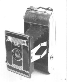
Equipment - Camera, C1939
Purchased by Ted Arrowsmith in 1940 from chemist at 596 Station Street Box Hill, when he lived at 35 Cambridge Street Box Hill. Used by him until the 1960s. Carried throughout Australia and the South West Pacific War Zone in the R.A.A.F between 1942 and 1946.Black folding bellows camera.AGFA 127. Folds back into a narrow case with handle. Instruction book included.|Agfa - Bilinar lens - aperture f11to f22. Two view finders one Portrait and other Landscape. Fixed speed of 1/30th second plus time exposure.AGFA - Bilinar. Made in germany.photography, cameras -
Whitehorse Historical Society Inc.
Newspaper - Article, Longview, 8/02/1994
... Road Surrey Hills Auctions 'View of Melbourne's harbor ...'View of Melbourne's harbor', article on 'Longview', built 1895 for the Morton family, at 21 Warrigal Road, Surrey Hills, Progress Press, 8 February 1994.krivanek, ivo, morton family, longview, warrigal road, surrey hills, auctions -
 Whitehorse Historical Society Inc.
Photograph, Eckermann's Poultry Farm, c1960
Photographs relate to the Poultry Farms that existed in Nunawading and Forest Hill in the1950s and 1960s. Photos taken in 1961-62. Poultry farmers included Messrs Boyce, Gallos, Foote,Grimsley, Greenwood and Dudley|Slides scanned as a 'tiff' at 300dpi to CD Rom and cleaned and adjusted by Ted Arrowsmith.View from Eckermann's Poultry Farm of Mrs White's house from Boyle's fence early in morning.eckermann's, eckermann frank, poultry farms, nunawading, greenwood, forest hill, canterbury road, mount pleasant road nunawading, boyles, white, bruer's -
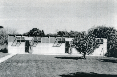
 Whitehorse Historical Society Inc.
Photograph, Eckermann's Poultry Farm, c1960
Photographs relate to the Poultry Farms that existed in Nunawading and Forest Hill in the1950s and 1960s. Photos taken in 1961-62. Poultry farmers included Messrs Boyce, Gallos, Foote,Grimsley, Greenwood and Dudley|Slides scanned as a 'tiff' at 300dpi to CD Rom and cleaned and adjusted by Ted Arrowsmith.View from Eckermann's Poultry Farm front of the saw tooth, 2nd last and last pen, taken across back lawn. Built 1956.eckermann's, eckermann frank, poultry farms, nunawading, greenwood, forest hill, canterbury road, mount pleasant road nunawading, boyles, white, bruer's -
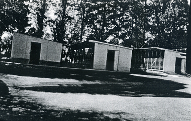
 Whitehorse Historical Society Inc.
Photograph, Eckermann's Poultry Farm, c1960
Photographs relate to the Poultry Farms that existed in Nunawading and Forest Hill in the1950s and 1960s. Photos taken in 1961-62. Poultry farmers included Messrs Boyce, Gallos, Foote,Grimsley, Greenwood and Dudley|Slides scanned as a 'tiff' at 300dpi to CD Rom and cleaned and adjusted by Ted Arrowsmith.View of Eckermann's Poultry Farm. The 'new shed' from the 2nd last pen looking across the back lawn. Pen used for pullet rearing.eckermann's, eckermann frank, poultry farms, nunawading, greenwood, forest hill, canterbury road, mount pleasant road nunawading, boyles, white, bruer's -
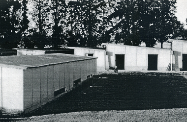 Whitehorse Historical Society Inc.
Photograph, Eckermann's Poultry Farm, c1960
Photographs relate to the Poultry Farms that existed in Nunawading and Forest Hill in the1950s and 1960s. Photos taken in 1961-62. Poultry farmers included Messrs Boyce, Gallos, Foote,Grimsley, Greenwood and Dudley|Slides scanned as a 'tiff' at 300dpi to CD Rom and cleaned and adjusted by Ted Arrowsmith.View of Eckermann's Poultry Farm. The pens from the top of the woodshed.eckermann's, eckermann frank, poultry farms, nunawading, greenwood, forest hill, canterbury road, mount pleasant road nunawading, boyles, white, bruer's -
 Whitehorse Historical Society Inc.
Photograph, Eckermann's Poultry Farm, c1960
Photographs relate to the Poultry Farms that existed in Nunawading and Forest Hill in the1950s and 1960s. Photos taken in 1961-62. Poultry farmers included Messrs Boyce, Gallos, Foote,Grimsley, Greenwood and Dudley|Slides scanned as a 'tiff' at 300dpi to CD Rom and cleaned and adjusted by Ted Arrowsmith.View of Eckermann's Poultry Farm. Eggshed and trees from the top of the woodshed.eckermann's, eckermann frank, poultry farms, nunawading, greenwood, forest hill, canterbury road, mount pleasant road nunawading, boyles, white, bruer's -
 Whitehorse Historical Society Inc.
Photograph, Eckermann's Poultry Farm, c1960
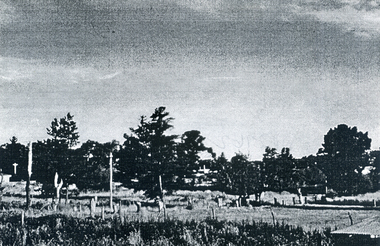
Photographs relate to the Poultry Farms that existed in Nunawading and Forest Hill in the1950s and 1960s. Photos taken in 1961-62. Poultry farmers included Messrs Boyce, Gallos, Foote,Grimsley, Greenwood and Dudley|Slides scanned as a 'tiff' at 300dpi to CD Rom and cleaned and adjusted by Ted Arrowsmith.View from Eckermann's Poultry Farm, looking towards Mt Pleasant Road from the top of the woodshed.eckermann's, eckermann frank, poultry farms, nunawading, greenwood, forest hill, canterbury road, mount pleasant road nunawading, boyles, white, bruer's -
 Whitehorse Historical Society Inc.
Photograph, Eckermann's Poultry Farm, c1960
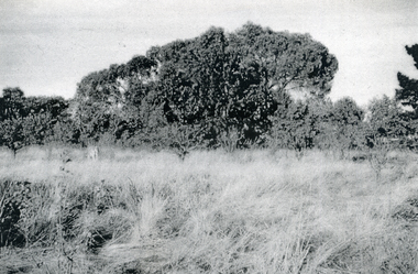
Photographs relate to the Poultry Farms that existed in Nunawading and Forest Hill in the1950s and 1960s. Photos taken in 1961-62. Poultry farmers included Messrs Boyce, Gallos, Foote,Grimsley, Greenwood and Dudley|Slides scanned as a 'tiff' at 300dpi to CD Rom and cleaned and adjusted by Ted Arrowsmith.View from Eckermann's Poultry Farm. Looking towards trees and Mr. Boyle's Orchard from the Eckermann fence, 'Corabelle' in the foregroundeckermann's, eckermann frank, poultry farms, nunawading, greenwood, forest hill, canterbury road, mount pleasant road nunawading, boyles, white, bruer's -
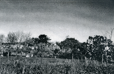
 Whitehorse Historical Society Inc.
Photograph, Eckermann's Poultry Farm, c1960
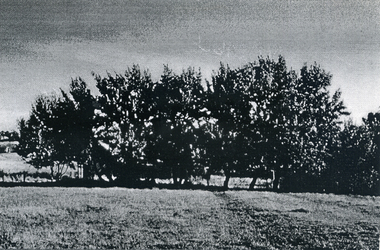
Photographs relate to the Poultry Farms that existed in Nunawading and Forest Hill in the1950s and 1960s. Photos taken in 1961-62. Poultry farmers included Messrs Boyce, Gallos, Foote,Grimsley, Greenwood and Dudley|Slides scanned as a 'tiff' at 300dpi to CD Rom and cleaned and adjusted by Ted Arrowsmith.View from Eckermann's Poultry Farm. Poplar trees and Mrs. White's house taken from the Cow Bail.eckermann's, eckermann frank, poultry farms, nunawading, greenwood, forest hill, canterbury road, mount pleasant road nunawading, boyles, white, bruer's -
 Whitehorse Historical Society Inc.
Photograph, Eckermann's Poultry Farm, c1960
Photographs relate to the Poultry Farms that existed in Nunawading and Forest Hill in the1950s and 1960s. Photos taken in 1961-62. Poultry farmers included Messrs Boyce, Gallos, Foote,Grimsley, Greenwood and Dudley|Slides scanned as a 'tiff' at 300dpi to CD Rom and cleaned and adjusted by Ted Arrowsmith.View from Eckermann's Poultry Farm. Looking towards the White's, Boyle's and Greenwood's properties on Canterbury.eckermann's, eckermann frank, poultry farms, nunawading, greenwood, forest hill, canterbury road, mount pleasant road nunawading, boyles, white, bruer's -
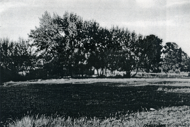
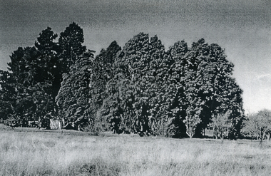 Whitehorse Historical Society Inc.
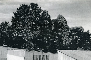
Photograph, Eckermann's Poultry Farm, c1960
Photographs relate to the Poultry Farms that existed in Nunawading and Forest Hill in the1950s and 1960s. Photos taken in 1961-62. Poultry farmers included Messrs Boyce, Gallos, Foote,Grimsley, Greenwood and Dudley|Slides scanned as a 'tiff' at 300dpi to CD Rom and cleaned and adjusted by Ted Arrowsmith.View of Eckermann's Poultry Farm. The cypress trees at the back of the farm.eckermann's, eckermann frank, poultry farms, nunawading, greenwood, forest hill, canterbury road, mount pleasant road nunawading, boyles, white, bruer's