Showing 864 items
matching water colour
-
 Lakes Entrance Regional Historical Society (operating as Lakes Entrance History Centre & Museum)
Photograph, Veronica Curtis, 2000 c
Similar enlarged copy from collection taken by Tambo Shire #02156 House has since been demolishedColour photograph of a timber holiday home built over the water at Box's Creek MetungBox's Creek Househouses -
Lakes Entrance Regional Historical Society (operating as Lakes Entrance History Centre & Museum)
Photograph, Lakes Post Newspaper, 2003
... Entrance gippsland Cemeteries Water supply Colour photograph ...Colour photograph showing Don Brady in the area cleared for a large water tank to be filled by the Fire Brigade as a water supply for the Lakes Entrance Garden Cemetery Palmers Road Lakes Entrance Victoriacemeteries, water supply -
Lakes Entrance Regional Historical Society (operating as Lakes Entrance History Centre & Museum)
Photograph, Judy Davies, 2010
... Entrance gippsland Cemeteries Water supply Colour photograph ...Colour photograph of monumental section of Bumberrah Cemetery near Johnsonville Victoriacemeteries, water supply -
Lakes Entrance Regional Historical Society (operating as Lakes Entrance History Centre & Museum)
Photograph, Wendy Price, 2008
This photograph was paired with image 03733 for display Lakes Entrance 150 years 1858 to 2008 held October 2008. Lake Tyers Beach originally known as Cross's Landing.Colour photograph of Lake Tyers taken from the car park below the Water Wheel Tavern looking N.E. showing waters of lake against steep shore Lake Tyers Victoriaocean, topography -
Lakes Entrance Regional Historical Society (operating as Lakes Entrance History Centre & Museum)
Photograph, 2/12/1999 12:00:00 AM
Also a colour photograph of swimmers at Main Beach Lakes Entrance in calm water during a heatwave, photograph was in Lakes Post 2 December 1999 number 03734.2 size 10 x 15 cmColour photograph of Christopher Wright-Smith playing in sand at Main Beach Lakes Entrance Victoriawaterways -
Lakes Entrance Regional Historical Society (operating as Lakes Entrance History Centre & Museum)
Photograph, Lakes Post Newspaper, 1/08/2001 12:00:00 AM
... Colour photograph showing turbulant water at the new... Entrance gippsland Waterways Forest Colour photograph showing ...Colour photograph showing turbulant water at the new entrance at Lake Tyers showing western barrier of the lake in background and sand dune in foreground being washed away Lake Tyers Victoriawaterways, forest -
 Lakes Entrance Regional Historical Society (operating as Lakes Entrance History Centre & Museum)
Photograph, Lakes Post Newspaper, 1999
number in album 03533.03Colour photograph at Aquadome Pool water aerobics instructor Jennifer Schembri-Portelli, at open day. Lakes Entrance Victoriarecreational facilities, health services -
 Lakes Entrance Regional Historical Society (operating as Lakes Entrance History Centre & Museum)
Photograph, Lakes Post Newspaper, 1999
... Entrance gippsland Water Resources Colour photograph of Robin ...Colour photograph of Robin Minter Mitchell River Supervisor and Simon Robertson East Gippsland Catchment Authority Engineer beside a waterway during a training course East Gippsland Victoriawater resources -
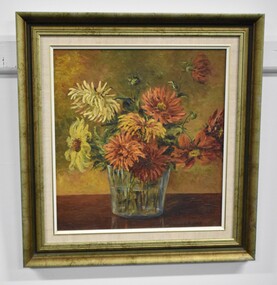 Tatura Irrigation & Wartime Camps Museum
Painting - Oil Painting, Flowers, 1942
The flowers in this painting were grown and tended to with love by Hans Beck in Tatura Camp 3.A glass vase containing orange, white and yellow flowers. The vase half filled with water and is sitting on a wooden table. The background is a mustard colour. The painting has a gold frame and with linen matt.C Rippertstill life, oil painting, flowers -
 Tatura Irrigation & Wartime Camps Museum
Photograph, Goulburn Murray Water Yard
... water wheels Colour photograph showing Goulburn Murray Water ...Shows picture of Goulburn Murray Water Yard, corner of Ross and William Streets, Tatura. Colour photograph showing Goulburn Murray Water Yard, corner Ross and William Streets, Tatura. Shed and water wheels. Photograph stuck onto piece of white cardboard. goulburn murray water, water wheels -
 Ballarat and District Irish Association
Photograph - digital, Shane Dunne, St Mary's Catholic Church Clarendon, 2014, 2014
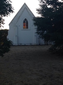
St Mary's Clarendon was dedicated on 09 November 1871. In 2014 it is part of St Alipius Parish, Ballarat East. "OPENING OF THE NEW CHURCH AT CLARENDON. On Thursday, November 9th, his Lordship the Bishop, accompanied by the various clergymen who assisted at the Mission, left Ballarat early in the morning, and proceeded through Buninyong to open the new church recently erected by the untiring exertions and liberality of the Catholics of Clarendon, and dedicated to the Blessed Virgin under the title of 'Auxilium Christianorum.' The church, which is composed of stone, with Lal Lal white brick facings, is 43 feet long by 20 feet wide, including a nice chancel, and has cost up to the present about £500. As the Bishop was approaching the locality, a large number of horsemen met and escorted, him to the church, arriving at 11 o'clock. Here also were a large number of children, 192, prepared for Confirmation, who were similarly attired as candidates in Ballarat. A procession, headed by the cross bearer and acolytes, was formed of the children and moved round the church, followed by the clergymen and the Bishop, who sprinkled the edifice with holy water. The building having been blessed and consecrated, High Mass, coram episcopo, was celebrated by the Very Rev. Dean Moore, the Rev. T. O'Donnell acting as deacon, Rev. M. J. Shanahan, as sub-deacon, and Rev. J. D. O' Sullivan, as master of ceremonies. After the Communion the Rev. J. D. O'Sullivan preached an impressive sermon on devotion to the Blessed Virgin. The collection amounted to about £40.9." (freeman's Journal, 25 November 1871)Six colour photographs of exterior and interior views of St Mary's Clarendon. st mary's clarendon, clarendon, st mary's, catholic -
 Brimbank City Council
Ledger, City of Keilor Ledger
City of Keilor Ledger - subdivisions, town works, water works, construction etc. Blue colour hard cover. -
 8th/13th Victorian Mounted Rifles Regimental Collection
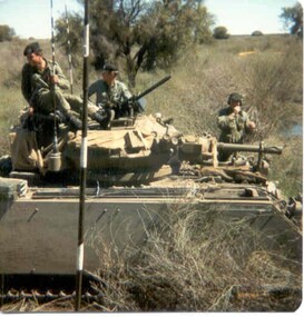
Photograph - Born digital image
A region on the Lachlan River flood plain north of Booligal New South Wales with its lightly timbered grassland criss-crossed with numerous flowing channels and water filled billabongs provided a challenging training area for a unit equipped with M113 family of vehicles. A Squadron 8/13 VMR deployed there in September 1985 for its annual exercise. The MRV was from 3 Troop commanded by Corporal RAC (Bob) MacDonald of Wangaratta Victoria. Army Reserve training in challenging countryColour image of M113 Medium Reconnaissance Vehicle(MRV) of A Squadron 8/13 Victorian Mounted rifles on annual exercise in Booligal region NSW, 1985.booligal, annual exercise, 8/13 victorian mounted rifles -
 South Gippsland Shire Council
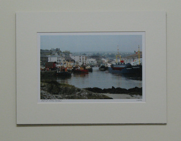
Print, Boats at Wicklow Harbour
Colour print of a watercolour painting titled "Boats in Wicklow Harbour". Set in cream card window mount. Features boats, water, buildings and low hills in the distance. Colours of red, greys, creams, blues and browns. Title printed lower left corner and artists signature lower right corner. Produced by Wicklow Scenic Prints. Made in Ireland. -
 South Gippsland Shire Council
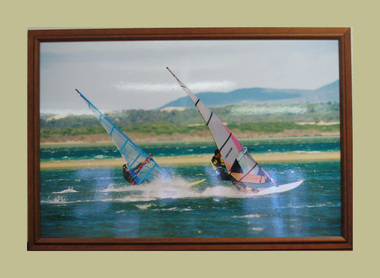
Photograph, Framed, 2003
Framed and laminated colour photograph featuring a beach scene with two windsurfers on the water. Land, beach and foliage in the background. Laminated surface and brown wood frame. -
 South Gippsland Shire Council
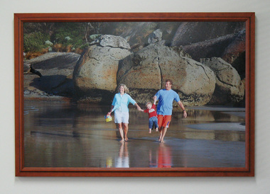
Photograph, Framed, 2003
Framed and laminated colour photograph featuring a small family on the water's edge.The mother and father are lifting a small child between them. Large rocks and boulders can be seen behind them. Brown wood frame. -
 Southern Sherbrooke Historical Society Inc.
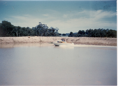
Photograph - Photo-colour- Bill Montague boat
Colour photograph of Bill Montague on his boat, on the dam at the orchard at Narre Warren. Bill is the only person on his boat whichmoves alone in the water as the dam bank and trees surround him. -
 Southern Sherbrooke Historical Society Inc.
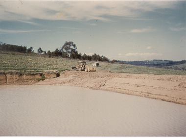
Photograph - Photo-colour- dam and tractor
Colour photograph of a tractor sitting near the dam at Narre Warren orchard. Green fields sit around the bank of the dam, with the water a brownish hue. -
 Southern Sherbrooke Historical Society Inc.
Photograph - Cardinia Reservoir works in conjunction with Wonthaggi Desalination Plant
Set of five colour photos showing preparations at Cardinia Reservoir, Narre Warren East, to allow for water to be pumped up from the Wonthaggi Desalination plant in November 2010. -
 Whittlesea Historical Society Inc.
Photograph, Carome, Mernda, c. 1960
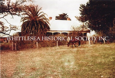
3 photographs showing Carome at Mernda dated mid 1960's. CAROME In 1840 Arthur Sergeantson purchased Section 19, Parish of Morang, a total of 842 acres. He named the property `Sergeantson Hall’ but the portion between the Plenty Road and Plenty River soon became known as Carome, the name of a flour mill he established in 1841. In 1843 Sergeantson leased the mill to a miller named Anderson, who operated it until 1850. Anderson was followed by Robert Charles. The present dwelling date back to at least 1850, and possibly earlier. In 1857 Sergeantson’s remaining 411 acres and Carome Mill were purchased by Abraham Willis and William Hardesty, who refurbished and upgraded the mill at the enormous cost of 1,200 Pounds. In 1868 the Mill was destroyed by fire. Willis continued farming at Carome until 1899 when he leased the farm to his son Robert and retired to Carlton. Little of the Mill remains. It was set just downstream from the deep rocky waterhole which formed a natural dam. Local folklore has it that this waterhole was used for water games by the Aborigines. Europeans certainly swim there now, and locals refer to this area as Power's hole, named after the previous owners the Power family. Such a prominent waterhole is likely to have been well known to the Aborigines. (Reference: City of Whittlesea Heritage Study) 3 colour photographs.mernda, carome mernda, bluestone, power family, willis family, abraham willis, isabella willis, carome mill, powers hole -
 Whittlesea Historical Society Inc.
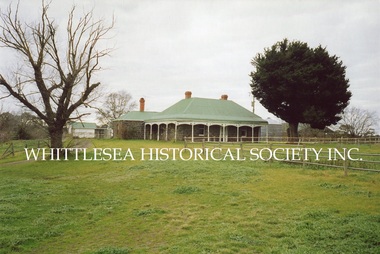
Photograph, Carome, Mernda, 2006
5 photographs showing Carome homestead and property at Mernda dated 2006. 1. Carome homestead. 2. Carome, looking southward down old rail line. 3. Carome homestead. 4. Dairy/feed sheds at Carome. 5. Carome property. CAROME In 1840 Arthur Sergeantson purchased Section 19, Parish of Morang, a total of 842 acres. He named the property `Sergeantson Hall’ but the portion between the Plenty Road and Plenty River soon became known as Carome, the name of a flour mill he established in 1841. In 1843 Sergeantson leased the mill to a miller named Anderson, who operated it until 1850. Anderson was followed by Robert Charles. The present dwelling date back to at least 1850, and possibly earlier. In 1857 Sergeantson’s remaining 411 acres and Carome Mill were purchased by Abraham Willis and William Hardesty, who refurbished and upgraded the mill at the enormous cost of 1,200 Pounds. In 1868 the Mill was destroyed by fire. Willis continued farming at Carome until 1899 when he leased the farm to his son Robert and retired to Carlton. Little of the Mill remains. It was set just downstream from the deep rocky waterhole which formed a natural dam. Local folklore has it that this waterhole was used for water games by the Aborigines. Europeans certainly swim there now, and locals refer to this area as Power's hole, named after the previous owners the Power family. Such a prominent waterhole is likely to have been well known to the Aborigines. (Reference: City of Whittlesea Heritage Study) 5 colour photographs.Printed on Kodak Royal Digital Papermernda, carome mernda, bluestone, power family, willis family, abraham willis, isabella willis, carome mill, powers hole, william hardesty, arthur sergeantson -
 Whittlesea Historical Society Inc.
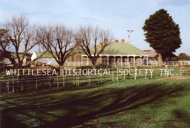
Photograph, Carome Homestead, Mernda, 1972
A photograph showing Carome homestead in Mernda dated 1972. CAROME In 1840 Arthur Sergeantson purchased Section 19, Parish of Morang, a total of 842 acres. He named the property `Sergeantson Hall’ but the portion between the Plenty Road and Plenty River soon became known as Carome, the name of a flour mill he established in 1841. In 1843 Sergeantson leased the mill to a miller named Anderson, who operated it until 1850. Anderson was followed by Robert Charles. The present dwelling date back to at least 1850, and possibly earlier. In 1857 Sergeantson’s remaining 411 acres and Carome Mill were purchased by Abraham Willis and William Hardesty, who refurbished and upgraded the mill at the enormous cost of 1,200 Pounds. In 1868 the Mill was destroyed by fire. Willis continued farming at Carome until 1899 when he leased the farm to his son Robert and retired to Carlton. Little of the Mill remains. It was set just downstream from the deep rocky waterhole which formed a natural dam. Local folklore has it that this waterhole was used for water games by the Aborigines. Europeans certainly swim there now, and locals refer to this area as Power's hole, named after the previous owners the Power family. Such a prominent waterhole is likely to have been well known to the Aborigines. (Reference: City of Whittlesea Heritage Study) Colour photograph.Printed on Kodak Professional Endura Paper.mernda, carome mernda, bluestone, power family, willis family, abraham willis, isabella willis, carome mill, powers hole, william hardesty, arthur sergeantson -
 Whittlesea Historical Society Inc.
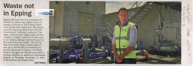
Newspaper - Article, Northern Star Weekly, Waste not in Epping, 9 Dec 2014
Information session on a "waste to energy" plant to be built in the Aurora housing estate Epping. Project manager Ian Donald pictured.Newsprint, text with colour photograph.ian donald, yarra valley water, epping, organic waste plant epping -
 Whittlesea Historical Society Inc.
Photograph, Maureen Doyle, Epping Catholic School
This colour photograph, along with 12 others, was taken of the former Catholic Denominational School No. 238 (now a residence) in Coulstock Street, Epping. The remains of Mr. Ryan's blacksmith forge are at the rear of the building. The building was for sale by auction when these photographs were taken. The exact date of construction of the bluestone school building is not known but was possibly during the 1860’s, after construction of St. Peter’s Catholic Church nearby. In 1934 a new primary school was built alongside St. Peters Church in Wedge Street and the bluestone school building sold to the Worn family and converted into a residence. Historical building of the City of Whittlesea.Colour photograph printed on Kodak Paper, photo 10 of 13.Annotation reverse: beehive water well Gwen Hawke Len Paulka.epping, bluestone house, catholic denominational school no. 238, coulstock street epping, st peter's catholic school epping, ryan's blacksmith forge, gwen hawke, len paulka -
 Ballarat Tramway Museum
Photograph - Colour Photograph/s - set of 10, Warren Doubleday, 20/01/2002 12:00:00 AM
Set of 10 colour photographs / prints of Scrubber 8 in Wendouree Parade and depot track on 20/1/2002, working and testing the sprinkler bar on No. 1 end of the tram. Photos by Warren Doubleday. On Kodak paper. 1962.1 - Scrubber 8 on access track .2 - At depot junction, with 45 behind, ice cream van alongside. .3 - With sprinkler bar operating .4 - ditto .5 - ditto .6 - showing the very end of the sprinkler bar under No. 1 end, at the back of the flusher hood. .7 - showing the valve and water line for the sprinkler bar. .8 - ditto .9 - showing the watered roadway coming down into depot junction from Carlton St. .10 - Simon Green cleaning depot junction points. (Photo used in Jan. 2002 Fares Please!) On .10 only in blue ink, date "20/1/02" scrubber tram, btm, sprinkler bar, depot junction, tram 8 -
 Ballarat Tramway Museum
Film - Movie Film & Box, 1970s
Movie Film - 16mm on a black metal reel, 91mm dia. Title: Train Carriages Interior Shots – Length 1:20 mins, colour, 16mm Colour with sound. (Reg Item 4110 - source not known at this time.) Time Sequence Description 0:00 Starts with a training running past, view of wooden carriages, C van and then interior shots of train, toilets, washbasin, electrical equipment, water dispenser, signs, seats, walk ways between carriages and light fittings. 1:20 End Placed in a blue cardboard box specially made for the item 30/08/2010. trams, tramways, victorian railways -
 Ballarat Tramway Museum
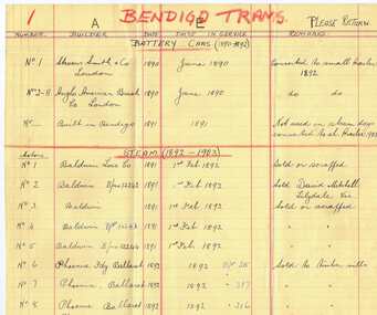
Document - List, Wal Jack, "Bendigo Trams", c1944
Yields information about Bendigo tramcars - provided in a list form that enabled sharing of the information with others.Hand written list of Bendigo tramcars on buff colour ledger paper - ruled with blue and red lines - two sheets or four pages listing tramcar numbers, builder, date in service, and whether sold or scrapped. Has "Please Return" on top right hand corner of first sheet. Page 1 - Bendigo Battery and Steam tram motors. Page 2 - Steam trailers Page 3 - Electric trams - with information through to 1943 Page 4 - Electric trams, electric trailers (double deck), and when last used and water tank scrubber - Bush of 1908, noted as "still in action". No mention of any bogie tramcars, so presumed made c1944 Contained originally within Reg Item 5623 at the front of this note book. For items see BTM5623 loose items list.pdf. bendigo, steam tram motors, trailers, tramcars -
 Ballarat Tramway Museum
Photograph - Colour Photograph/s - set of 2, Stephen Butler, c9/1978
Yields information about the construction of the BTPS Depot extensions c Sept. 1978.Set of 2 colour prints of tram the depot extensions being constructed c September 1978. .1 - view from 2 /3 road points with a tram on the 3 road extension. .2 - photo of 4 road pit with water in it. See Annual Report and September 1978 Fares Please!trams, tramways, btps, depot extensions -
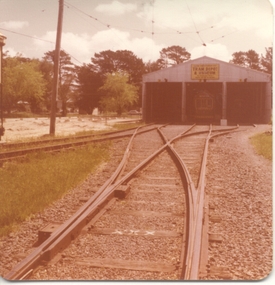
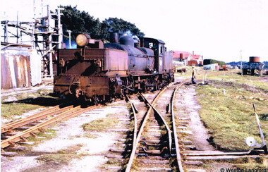 Otway Districts Historical Society
Photograph, Langford, Weston, Beech Forest: G42 traversing the scissors crossover, 1961, 9 August 1961
Colour. Locomotive G42 traversing the scissors or delta crossover during shunting operations at Beech Forest on 9 August 1961. A man operates the points. To the right the Beech Forest Hall and Otway Shire offices, and the Water Tank for the use of locomotives. On the left, the remains of a timber extraction system.beech forest; railways; delta crossing; scissors crossing; -
 Otway Districts Historical Society
Photograph, Langford, Weston, Gellibrand after closure, 1964, 26 April 1964
Colour. After closure of the railway line, Gellibrand looking towards Beech Forest on 26 April 1964. The station buildings and water tank are still standing as well as clear impressions left by the tracks. Telephone lines are marked. A person is near the water tank.gellibrand; railways;