Showing 25291 items
matching north or new hustlers
-
 Ringwood and District Historical Society
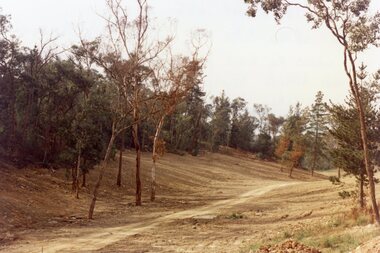
Photograph, View up the gully from Glenvale Road, North Ringwood towards the spot of the wall of Loughnan's Lake was
The brown undergrowth is on the remains of the walls, since levelled. Circa 1979. Part of a 51-photo record of the development of the "Kubis" Estate, Ringwood North, including road works to Debbie Place, Kubis Drive, Werac Drive, Manuelo Drive, Iluka Place and Glenvale Road. From the Jack Lundy Clarke collection. -
 Ringwood and District Historical Society
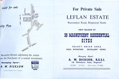
Document - Folder, Land Sale - Leflan Estate, North Ringwood, Vic. - circa 1967
Bi-fold land sale advertisements for stages 1 and 3 releases of residential allotments in Leflan Estate, Ringwood North, circa 1965-1967. Brochures include area map, layout of the estate, and summary of local facilities and services, with separate attachment listing lot number prices for 2nd and 3rd releases.Subdivision includes Melview Drive, Leslie Grove, Leflan Close, Warrandyte Road and Lockhart Street. Agent - A.W. Dickson, R.E.S.I., 136 Whitehorse Road, Ringwood. (Phone) 870-6007, 870-7016, After hours 870-6868. -
 City of Ballarat Libraries
Photograph - Card Box Photographs, 8010 Peel Street North, Ballarat circa 1928
8010 Peel Street North was located opposite the Eastern Oval. Pictured are Mrs V. Healy, Mary Larkin, and Molly, Noreen and Eileen Healy.peel street north, ballarat, v. healy, mary larkin, molly healy, noreen healy, eileen healy, private dwelling, building -
 Ringwood and District Historical Society
Biographical material, Houghton, Murray E, Material re Julius Grant , North Ringwood resident in 1930s and Warrandyte Councillor. Also re "Lorna Larna", 2008
Murray Houghton compiling a biography of Angela and James Booth of Warrandyte in the 1920s and 30s stated that they had a close connection with Julius Grant, who among other things was prominent member of the Adam Lindsay Gordon Memorial Committee in the 1920s.30 typed pages plus letter about Julius Grant, resident of North Ringwood in 1930s, and 12 pages about Julius Grant when he was a councillor in Warrandyte, with 9 pages about Julius Grant of "Lorma Larna" +Additional Keywords: Grant, Julius / Booth, Angela / Booth, James / Houghton, Murray -
 National Vietnam Veterans Museum (NVVM)
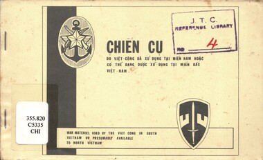
Booklet, United States Army, Chien Cu: War Material used by the Viet Cong in South Vietnam or presumable available to North Vietnam, 1966
A cream coloured booklet with black information. There are two insignias in black. Some of the information on the front cover is in vietnamese.Weapons and equipment used by the Vietcong in South Vietnam or presumably available to North Vietnam. The context of the booklet are both English and Vietnamese. There ae two staples down the left hand side. The booklet is covered in clear plastic.vietnam war, 1961-1975 - weapons, south vietnam, north vietnam -
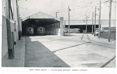 Melbourne Tram Museum
Photograph - Illustration, Melbourne & Metropolitan Tramways Board (MMTB), "New Tram Depot - Nicholson Street North Fitzroy", mid 1950's
Illustration, black and white, printed on gloss paper, reproduction of a MMTB report of photographs of the opening of the new North Fitzroy Tram depot, the three road depot, adjacent tracks and the bus depot. Has a number of trams in the view. Cars 1024 and 1031? Shows the nature of the crossing with the resilient inserts - it did not work as planned.trams, tramways, opening, north fitzroy, depots, bourke st, nicholson st, tram 1024, tram 1031, north fitzroy depot, mmtb buses -
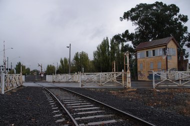 Victorian Interpretive Projects Inc.
Photograph, Elaine Murphy, Ballarat Railway Gates, 03/05/2012
Railway track running through the gates at Humffray Street (North) Ballarat. Signal box in foreground and Ballarat Station in the BackgroundRailway track going through gates at Humffray Street (North), Ballarat. Signal box on the right of photo, Ballarat station in background. railways, gates, building, signal box, lights, tracks, train, ballarat station, lines, road, rust, lights, ballarat, graffiti. -
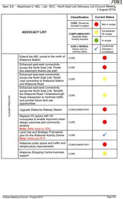 Greensborough Historical Society
Document, Advocacy list (North East Link), 05/08/2019
Attachment to Item 5.6, Ordinary meeting of Council 5 August 2019, discussing the North East Link and possible impacts on the City of Banyule, including Watsonia.5 pages, typescriptnorth east link, watsonia station, watsonia -
 Eltham District Historical Society Inc
Photograph, North Riding Living & Learning Centre
One of a set of display images thought to be produced by the Shire of Eltham c.1979-1987. The North Riding Living and Learning Centre was located in Panton Hill.Illustrative of services provided by former Shire of ElthamColour photograph 20 x 29 cm mounted on green-painted chipboard 28 x 35.5 cm (string on back for hanging)Title printed on label adhered to board below photograph (replaced June 2017)living and learning centre, panton hill -
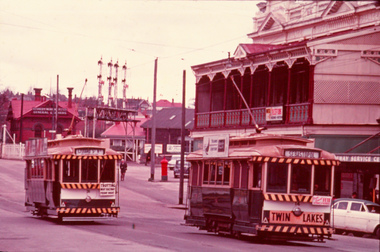 Ballarat Tramway Museum
Slide - 35mm slide/s, Max Michell, No. 14 southbound in Lydiard St North, Sep. 1971
Yields information the operation of trams prior to the closure of the SEC system near the Railway Station. Has a strong association with the work of the Association of Railway Enthusiasts.AGFA blue and white plastic mount, 35mm slide, from the Association of Railway Enthusiast's film strip titled "Provincial Tramway Film Strip" of No. 14 southbound in Lydiard St North with a Twin Lakes and an auxiliary board advertising a Fete. No. 31 is northbound to Lydiard St North with an auxiliary board "Trotting Bray Raceway Friday Night". Photo taken Sept. 1971. In the background is the railway level crossing signal gantry and Reid's Coffee Palace. Note the letter box at the railway station yard. The film strip notes (Reg. Item 2560), provided the following caption details: "No. 31 and 14 cross at the end of the double track outside the Ballarat Coffee Palance - Oct. '68" Photo Max Michell Slide No. 7 Various notations by John as to the slide number and the trams in pencil and ink.tramways, trams, are, film strip, level crossings, lydiard st north, bray raceway, tram 31, tram 14 -
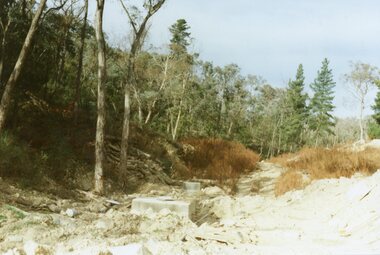
 Ringwood and District Historical Society
Photograph, Kubis Estate, North Ringwood in April 1978. View of the lake site looking east. The wall was where the track bends. The rope tree was on the hillside beyond the track bend
E548 N35 This photo was taken from almost the same spot as the 1976 one. Part of a 51-photo record of the development of the "Kubis" Estate, Ringwood North, including road works to Debbie Place, Kubis Drive, Werac Drive, Manuelo Drive, Iluka Place and Glenvale Road. From the Jack Lundy Clarke collection. -
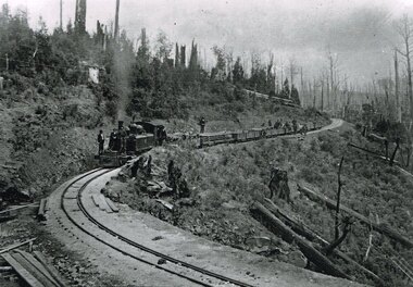 Otway Districts Historical Society
Photograph, Victorian Railways, Beech Forest: From 27 miles 16 chains looking north, c.1901, 1901
B/W. 168mm x 246mm. Colac - Beech Forest railway line. From the 27 mile 16 chains line (44.7 km) looking north, between Devitt Bros. Siding (44.1 km) and Ditchley (47 km). On an NA-class locomotive, six NQR wagons, and an open wagon there are workmen throughout. colac; beech forest; railways; devitt bros. siding; ditchley; loco na class -
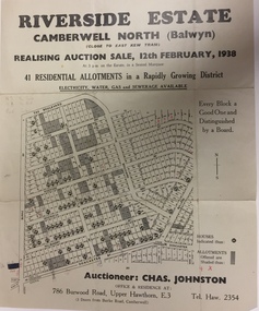 Kew Historical Society Inc
Plan - Subdivision Plan, Riverside Estate, Camberwell North (Balwyn), 1938, 1939
This subdivision known as the Riverside Estate wa sone of the largest and most significant in Balwyn's history.Subdivision Plan for 41 lots within the wider Riverside Estate in Camberwell North, now Balwyn, in February 1938. The auction featured lots in Burke Road, The Boulevard, Mt View Road, Wattle Avenue, Kyora Parade, Cascade Street, Riverside Avenue, Walbundry Avenue, Inverness Way, Bulleen Road and Doncaster Road.Allotments for sale are shaded grey on the map. Certain lots have an H in a circle. These are presumably where houses had already been constructed.subdivision plans - balwyn (vic), riverside estate - balwyn (vic) -
 Melbourne Tram Museum
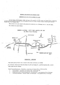
Document - Timetable/s, Notice, Melbourne & Metropolitan Tramways Board (MMTB), "Introduction of new Weekday Express Bus Service - North Altona - City Bus Route No. 232", Nov. 1978
Photocopy onto a foolscap double sided, of the introduction of a new bus service along the West Gate Freeway - 20/11/1978 - titled "Introduction of new Weekday Express Bus Service - North Altona - City Bus Route No. 232". Shows a map of the service, details of connecting services, stopping places, fares and timetable.trams, tramways, buses, timetables, north altona, route 232 -
 Ringwood and District Historical Society
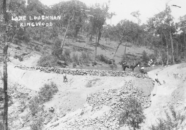
Photograph, Building the recreational man-made lake on the north side of Loughnans Hill: "Lake Loughnan". (Undated)
Printed on photo "Lake Loughnan Ringwood"Typed below photograph, "Building the recreational man-made lake on the north side of Loughnans Hill. It was the local swimming hole in Werac Drive gully beyond Kubis Drive. Now site of a new housing estate." Written on Photo "Lake Loughnan Ringwood" -
 Ringwood and District Historical Society
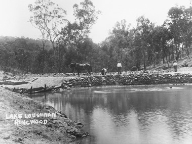
Photograph, Building the recreational man-made lake on the north side of Loughnans Hill
Typed below photograph, "Building the recreational man-made lake on the north side of Loughnans Hill. It was the local swimming hole in Werac Drive gully beyond Kubis Drive. Now site of a new housing estate". Written on photo: Lake Loughnan Ringwood -
 Greensborough Historical Society
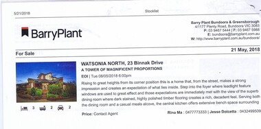
Advertising Leaflet, 23 Binnak Drive Watsonia North, 21/05/2018
23 Binnak Drive Watsonia North, 4 bedroom home. For sale 19/05/2018. Previous sale September 2015 for $918,000 and February 1985 for $35,000.Real estate advertising leaflet, 1 sheet, printed in colour.binnak drive watsonia north -
 Greensborough Historical Society
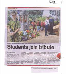
Newspaper Clipping, Students join tribute Watsonia North Primary WN4988, 19/08/2015
Students from many schools in the area laid wreaths to commemorate the Battle of Long Tan during the Vietnam War, including those from Watsonia North Primary.News clipping, black text, colour image.watsonia north primary school, battle of long tan, greensborough war memorial park -
 Eltham District Historical Society Inc
Photograph, Queenstown North State School, c.1910
School building now at Berwick State School (for short time was used at Queenstown North for some sort of home for boys) - Kent Hughes. Cross Ref: 0151This photo forms part of a collection of photographs gathered by the Shire of Eltham for their centenary project book,"Pioneers and Painters: 100 years of the Shire of Eltham" by Alan Marshall (1971). The collection of over 500 images is held in partnership between Eltham District Historical Society and Yarra Plenty Regional Library (Eltham Library) and is now formally known as the 'The Shire of Eltham Pioneers Photograph Collection.' It is significant in being the first community sourced collection representing the places and people of the Shire's first one hundred years.Digital image, 9 x 12.5 cm print and 4 x 5 inch B&W Neg sepp, shire of eltham pioneers photograph collection, queenstown, st andrews, queenstown state school no. 3594 -
 Eltham District Historical Society Inc
Photograph, Queenstown North State School, No. 3594, c.1915
School building now at Berwick State School (for short time was used at Queenstown North for some sort of home for boys) - Kent Hughes. Cross Ref: 0150This photo forms part of a collection of photographs gathered by the Shire of Eltham for their centenary project book,"Pioneers and Painters: 100 years of the Shire of Eltham" by Alan Marshall (1971). The collection of over 500 images is held in partnership between Eltham District Historical Society and Yarra Plenty Regional Library (Eltham Library) and is now formally known as the 'The Shire of Eltham Pioneers Photograph Collection.' It is significant in being the first community sourced collection representing the places and people of the Shire's first one hundred years.Digital image, 9 x 12.5 cm print and 4 x 5 inch B&W Negsepp, shire of eltham pioneers photograph collection, queenstown, st andrews, queenstown state school no. 3594 -
Moorabbin Air Museum
Book - Development history moving onto usage during WW2 and afterwards incl usage by various nations, CROWOOD AVIATION SERIES NORTH AMERICAN P-51 Mustang, Malcolm V. Lowe, CROWOOD AVIATION SERIES NORTH AMERICAN P-51 Mustang, 2009
Development history moving onto usage during WW2 and afterwards incl usage by various nations, CROWOOD AVIATION SERIES NORTH AMERICAN P-51 MustangGrey jacket cover showing closeup and slightly above colour photo of in flight Mustang British markings, over fieldsnon-fictionDevelopment history moving onto usage during WW2 and afterwards incl usage by various nations, CROWOOD AVIATION SERIES NORTH AMERICAN P-51 Mustang -
 Bendigo Military Museum
Photograph - Royal Australian Survey Corps Surveyors in the Field – North Queensland and Torres Strait, 1961
This is a set of five photographs of surveyors and support staff in the field undertaking duties in North Queensland and Torres Strait in 1961. The surveyors were employed in the establishment of mapping and geodetic control. In this era surveyors used theodolites to observe horizontal and vertical angles and tellurometers to measure base line distances between survey stations. In photo .2P Joe Farrington is seen taking survey observations using a Tavistock V500 Series Tavistock theodolite at a survey station between the Edward River and Aurukun in the Cape York Peninsula. The Gulf of Carpentaria appears in the background. From 1957 helicopter transport of survey parties revolutionised transport in remote areas. The civilian helicopter was hired from TAA. This is a set of five photographs of surveyors and support staff in the field undertaking duties in North Queensland and Torres Strait in 1961. The photographs were printed on photographic paper and are part of the Army Survey Regiment’s Collection. The photographs were scanned at 300 dpi. .1) - Photo, colour, 1961. Andy Millar occupying a survey station on a hill in the Cape York Peninsula, QLD. .2) - Photo, colour, 1961. Joe Farrington taking observations with a V500 Series Tavistock geodetic theodolite at a survey station in the Cape York Peninsula, QLD. .3) - Photo, colour, 1961. Daryl Parker taking a break from survey observations on a hill located on Duaun Island QLD, in the Torres Strait, a few miles south of the PNG coastline. Hill height was 975 ft. .4) - Photo, colour, 1961. Three Torres Strait divers L to R: unidentified, Darku and Ray Mau Daryl standing behind a Tavistock geodetic theodolite on a hill located on Duaun Island QLD, in the Torres Strait, a few miles south of the PNG coastline. .5) - Photo, colour, 1961. Andy Millar holding meat from a small turtle on Duaun Island QLD, in the Torres Strait, a few miles south of the PNG coastline. An unidentified Duaun Island local appears in the background..1P to .5P annotated on back – personnel names, the year and the location. royal australian survey corps, rasvy, army survey regiment, asr, army svy regt, fortuna, surveying -
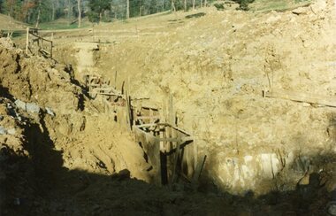 Ringwood and District Historical Society
Photograph, Kubis Estate, North Ringwood on 10 June 1978. Trench for sewer below the manhole
E550 N7 The hole for the 27 feet deep well shows as a white patch, lower right. Part of a 51-photo record of the development of the "Kubis" Estate, Ringwood North, including road works to Debbie Place, Kubis Drive, Werac Drive, Manuelo Drive, Iluka Place and Glenvale Road. From the Jack Lundy Clarke collection. -
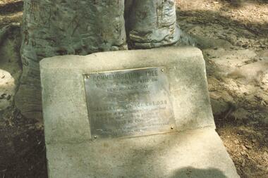 Ringwood and District Historical Society
Photograph, Commemoration Tree Plaque, North Ringwood Primary School - circa 1990s
Commemoration Tree and plaque in the grounds of North Ringwood Primary School in Oban Road. These coloured photographs are undated, however the playground equipment suggests circa 1990s. The plaque mounted at the base of the tree in 1965 reflects the wording of a sign attached to the tree when it was planted ten years earlier, in 1955. (See also Reg. no. 139 - "Commemoration Tree"). Writing on plaque reads, "Commemoration Tree. This tree was planted on Remembrance Day 11th November 1955 by Maj. Gen. L.E. Beavis, C.B, CBE, DSO in memory of all servicemen who took part in the wars of 1914-18 and 1939-45. Lest We Forget. Presented by Ringwood Sub-branch R.S.S.A.I.L.A. 11th November 1965" -
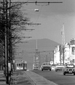 Ballarat Tramway Museum
Photograph - Digital image, Peter Bruce, Sturt St into Drummond St North at 1.55pm, 1970s
Yields information about the Sturt St landscape looking east.Digital Image of a tram turning from Sturt St into Drummond St North at 1.55pm - long telephoto lens shot from about Ripon St, looking east. Mt Warrenheip in the far background. Photo taken by Peter Bruce 1970's and 1971 prior to the closure of the Ballarat System. Peter's Title of image: 1.55pmtrams, tramways, ballarat, sturt st, town hall, drummond st nth -
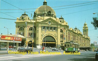 Melbourne Tram Museum
Postcard, Stewart Postcards, SW6 965 route 48, North Balwyn, late 1980's
Postcard, coloured, of SW6 965 route 48, North Balwyn, in Flinders St with the Flinders St station in the background and the Flinders Gate podium which has an advert for "FEIP". Back has space for name and address, stamp and a message and details of the postcard. Produced by Stewart Postcards. Has "Greetings from Melbourne Australia" along the bottom edge.trams, tramways, flinders st station, swanston st, sw6 class, route 48, tram 965 -
 City of Ballarat Libraries
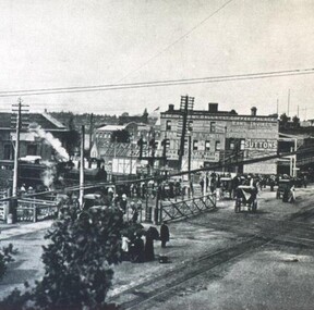
Photograph - Card Box Photographs, Lydiard Street North Railway Station Crossing 1915
Photo of the Lydiard Street North Railway Crossing complete with the railway gates from the Ballarat Homecoming publication. Also seen in the photo is Reid's Coffee Palace and the electric tram line. railway gates, lydiard street north, ballarat, public, reid's coffee palace, railway crossing, streetscape, ballarat homecoming -
Friends of Ballarat Botanical Gardens History Group
Work on paper - Chas Walker & Co., Auctioneers and General Agents, Receipts.1928,1931, Monies Paid by Mrs Charlotte Beaton, relative of Mrs Ruth Beaton, who occupied North Lodge, BBG
Chas Walker & Co., Auctioneers and General Agents, Receipts.1928,1931. Monies Paid by Mrs Charlotte Beaton, relative of Mrs Ruth Beaton, who occupied North Lodge, BBG.john garner collection, ballarat botanical gardens, beaton, north lodge, chas walker, auctioneer, gardens, ballarat -
 Eltham District Historical Society Inc
Photograph, Barry Philp, Looking north from Main Road to Storey Avenue, Research, c.1969
Taken from Main Road looking north to the houses in Storey Avenue and the Maroondah Aqueduct. From the appearance of the pine trees along the aqueduct it was taken just after the 1968-1969 fire.research (vic.), bushfires, main road, maroondah aqueduct, pine trees, storey avenue, victorian bushfires - 1969 -
![Work on paper - Newsletter, North East Link getting it right [June 2020], 2020_06](/media/collectors/4f729f5697f83e03086015b8/items/6014ef952bef110c704f3c4c/item-media/6014f0882bef110c704f42bf/item-fit-380x285.jpg) Greensborough Historical Society
Greensborough Historical SocietyWork on paper - Newsletter, North East Link getting it right [June 2020], 2020_06
Banyule City Council comments on the North East Link project. This newsletter is to keep the community informed of developments. Includes a sketch map from the M80 Ring Road to Lower Plenty Road.2 page leaflet, colour text and images.north east link, banyule city council, watsonia