Showing 2286 items matching " parish."
-
 Glenelg Shire Council Cultural Collection
Photograph - Photograph - Casterton, Victoria, c. 1963
SOURCED FROM CASTERTON TOWN HALL (FORMER SHIRE OF GLENELGBlack and white photo, Sacred Heart Parish Church, Casterton.Back: Black stamp '063826'tourism, postcard, photography -
 Bendigo Historical Society Inc.
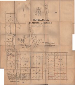
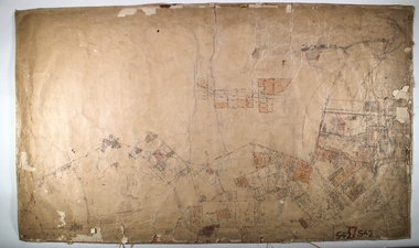
Map - JACK FLYNN COLLECTION: TARNAGULLA SHEET 1, No date visible
Map: Parish of Tarnagulla Sheet 1, Counties of Gladstone and Bendigo.map, gladstone, parish plan, tarnagulla sheet 1 -
Bendigo Historical Society Inc.
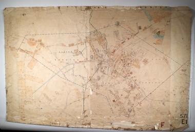
Map - CITY OF SANDHURST RESURVEY SHEET NO. 3, 13/05/1881
Map: City of Sandhurst Resurvey sheet No. 3. Parish plan.map, bendigo, parish plan, sandhurst, resurvey -
 Bendigo Historical Society Inc.
Map - EAGLEHAWK, Circa 1870's
Map: Eaglehawk, Compilation of 2 parish plans covering Eaglehawkmap, bendigo, parish plan, eaglehawk -
 Bendigo Historical Society Inc.
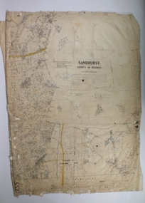
Map - SANDHURST SHEET 1, 27/05/1925
Map: Sandhurst ,County of Bendigo, sheet 1. Parish planmap, bendigo, parish plan, sandhurst -
 Bendigo Historical Society Inc.
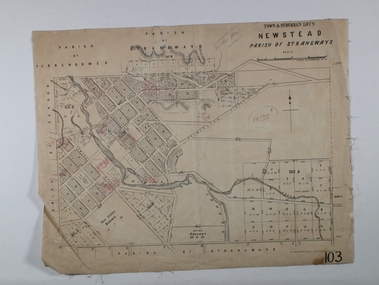
Map - NEWSTEAD ALLOTMENTS, 10/06/1886
Map: Town ans Suburban Lots, Newstead, Parish of Strangwaysmap, allotments, newstead , allotments, parish of strangways -
 Bendigo Historical Society Inc.
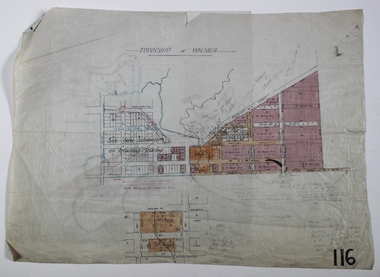
Map - WALMER, Circa 1900
Map: Township of Walmer, 2 hand Draughted Parish plansmap, township, walmer -
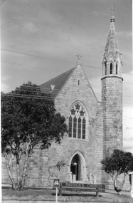
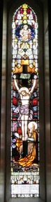 Christ Church Anglican Parish of Warrnambool
Memorial Window: John Edward BENNETT, Crucifixion "I, if I be lifted up from the earth/ will draw all men unto me"
John Edward Bennett was born in Leeds, Yorkshire, 1862. He was devoted to his family and his church, being a churchwarden and a verstryman of this Parish. He was a lay preacher for 40 years in the Dioceses of Melbourne and Ballarat. He was the first Manager of the Warrnambool Woollen Mill. He died on Nov 10th 1928.He was the first manager of Warrnambool Woollen Mill.Stained glass memorial lancet window, central light, west wall, north nave, depicting the crucifixion of Jesus.To the Glory of God and in loving memory of/John Edward Bennett/ sometime Churchwarden and Vestryman of this Parish, and for/40 years a Lay Reader in the Dioceses of Melbourne and/ Ballarat, born in Leeds, Yorkshire, 1862, entered into rest Nov 10th, 1928/ A devoted husband and father,/ a faithful servant of God and His Church/Not slothful in business, fervent in spirit, serving the Lord.memorial stained glass window lancet window bennett je bennett john edward bennett warrnambool woollen mill -
 Bendigo Historical Society Inc.
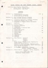
Document - CHURCHES OF BENDIGO COLLECTION: PARISH PROOFILE FOR HOLY TRINITY PARISH, BENDIGO
Twenty seven pages document. Parish profile for Holy Trinity Parish, Bendigo. Involving: Holy Trinity, Flora hill - Christ Church, Bendigo East - St. Stephen's, Emu Creek.church, history, anglican church -
 Bendigo Historical Society Inc.
Map - JACK FLYNN COLLECTION: HUNTLY, 12.03.1932
Map: Township of Huntly, Parish of Huntly , County of Bendigo. Parish plan. Western and South Riding Division on Main St. (Main Northern Highway) - written in ink below name of map.BY Authority H.J. Green. Photo-Lithographed at the Dept., of Lands and Survey, Melbourne. 12.3.32map, bendigo, township, huntly -
Bendigo Historical Society Inc.
Map - HUNTLY, SHEET 4, 29/03/1876
Map: Parish of Huntly, Sheet 4, County of Bendigo. Hand Draughted Parish plan. Originally in Map Cupboard. Relocated to Map Drawer 5 on 22.9.22. Too long for the map cupboard.map, bendigo, parish plan, huntly -
Tarnagulla History Archive
Photocopies of historic maps - Tarnagulla region, varied
David Gordon Collection. Four photocopies in clear sleeve: (a) topographic with mines near Tarnagulla (b) Parish map ?- Tarnagulla & surrounds (c) Parish map ?- Tarnagulla & surrounds (d) Plan of Roads, Tarnagulla & Newbridge -
 Bendigo Historical Society Inc.
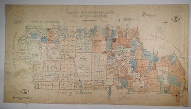
Map - SPRING PLAINS, Examined 31/01/1876
Map: Parish of Springplains, County of Dalhousie. Parish plan June 1874 A.D. Scott Examined E.D. 4.7.74 Additions made March 1877 Written in blue " See new plan."map, dalhousie, parish plan, spring plains, a. d. scott -
 Bendigo Historical Society Inc.
Map - NEILBOROUGH, 21/01/1875
Map: Parish of Neilborough, County of Bendigo. Hand draughted Parish plan. Resurveyed by Mr Assistant-Surveyor G Black. Drawn by W A Taylor. Map dated 21/1/1875.map, bendigo, parish plan, neilborough, g. black, w.a. taylor -
 Stawell Historical Society Inc
Photograph, St. Patrick’s Catholic Church c 1965-1970
Views of St. Patrick’s Catholic Church. Two of the photos are identical showing the parish hall on left of photo and a small part of priest's residence on right. A car can be seen parked below the church fence. Photo recorded to be taken by Ruby Willy Estate. The other photo shows a different view with a timber sign out the front of the church and two trees either side of the sign. This third photo also just shows the priests house on the right and taken around 1965 -1970.Three black and white photos of St Patrick's Church. Two are identical showing parish Hall on left of photo and small part of priest's residence on right. The other photo of the church taken at a different angle shows two trees and a church sign out the front. Electricity lines can be seen across the photo.stawell -
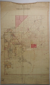
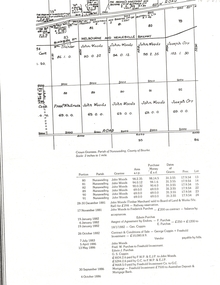
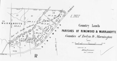 Ringwood and District Historical Society
Photograph, Early map of parishes of Ringwood and Warrandyte in Counties of Evelyn and Mornington - c.1868, 1868
Copy of an early map of parishes of Ringwood and Warrandyte, Counties if Evelyn and MorningtonWritten on backing sheet, "c1868. Vol. 5, Fol.13/1224". -
 Bendigo Historical Society Inc.
Map - JACK FLYNN COLLECTION: COHUNA, 1963
Map: Photocopy of parish plan showing Cohuna and a portion of the Gunbower Creek.By Authority. A.C. Brooks Government Printer, Melbourne. Drawn and Reproduced at the Department of Lands and Survey, Melbourne.1963.map, gunbower, parish plan, cohuna , gunbower creek -
Bendigo Historical Society Inc.
Map - SANDHURST (PART), Circa 1880's
Map: Parish plan showing Charleston Rd. Lloyd St. areamap, bendigo, parish plan, sandhurst, charleston road, lloyd street -
Bendigo Historical Society Inc.
Map - LYELL, 4/06/1873
Map: Lyell. Parish plan (number 278 in map cupboard 1)map, bendigo, parish plan, lyell -
Whitehorse Historical Society Inc.
Document, St John's Blackburn, St Alfred's Blackburn North, 1/12/1979 12:00:00 AM
Parish of Blackburn Statement of payments and reimbursements for year ending December 1979.Parish of Blackburn Statement of payments and reimbursements for year ending December 1979.Parish of Blackburn Statement of payments and reimbursements for year ending December 1979.st johns anglican church, blackburn, st alfred's anglican church, blackburn north -
 Whitehorse Historical Society Inc.
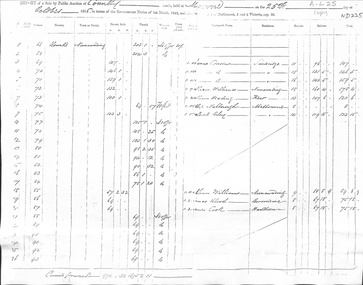
Document - Report, Land Sale, 01/10/1855
Report of land sale by public auction, Parish of Nunawading, October 1855cousens, james, williams, william, heading, nalborough, phillip, riley, patrick, blood, thomas, cook -
 Whitehorse Historical Society Inc.
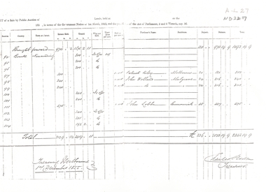
Legal record - Report, Land Sale, 01/10/1855
Report of land sale by public auction, Parish of Nunawading, October 1855Report of land sale by public auction, Parish of Nunawading, October 1855Report of land sale by public auction, Parish of Nunawading, October 1855riley, patrick, holland, john, lobb, land sales -
 Whitehorse Historical Society Inc.
Document, Plan of Blackburn, 1886
Crown grants, Parish of Nunawading, County of Bourke,Crown grants, Parish of Nunawading, County of Bourke, covers the Blackburn area.Crown grants, Parish of Nunawading, County of Bourke,woods, john, purches, edwin james, coppin, george seth, parish of nunawading, county of bourke, blackburn, tranter, william, orr, joseph, whitman, frank -
Lakes Entrance Historical Society
Book, Bundalaguah Centenary Committee, Back to Bundalaguah, 1972
A souvenir booklet produced for the centenary of the Parish and township of Bundalaguah Gippsland Victoriatownship, settlers, agriculture, education -
 Bendigo Historical Society Inc.
Map - SANDHURST (PART), No date visible
Map: Parish plan showing the Southwestern corner of Sandhurst to the Municipal boundarymap, bendigo, parish plan, sandhurst -
 Bendigo Historical Society Inc.
Map - SANDHURST ? SHEET 5, 29/10/1879
Map: Parish plan showing area Northwards from Kangaroo Flatmap, bendigo, parish plan, parish of sandhurst, kangaroo flat -
 Bendigo Historical Society Inc.
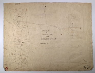
Map - LODDON CREEK, Circa 1860
Map: Plan of agricultural lands upon the Loddon Creek in the parish of Shelbournemap, bendigo, agricultural lands, agricultural lands, loddon creek, shelbourne -
Bendigo Historical Society Inc.
Map - SUBDIVISION OF STERNBERG'S ESTATE, 24/06/1920
Map: Subdivision of Sternberg's Estate, Crown Allotments 75, 76, 76A, 76B and 77, Parish of Rochester West, County of Bendigo. Parish plan Canvas backed ( number 133 in Map Cupboard 1)map, bendigo, rural, sternberg's, crown allotments 75, 76, 76a, 76b, 77, rochester west, county of bendigo -
Bendigo Historical Society Inc.
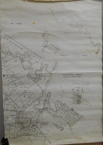
Map - PARISHES OF CORNELLA AND TOOLLEEN, Circa 1880
Map: Parishes of Cornella and Toolleen, Compilation of 2 hand draughted parish plans applied to vanvas backing. Originally in Map Cupboard. Relocated to Map Drawer 5 on 5.22.9.22. Too long for the map cupboard.map, parish plan, cornella , toolleen -
 Bendigo Historical Society Inc.
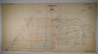
Map - PARISH OF CAMPASPE, November 1880
Map: Parish of Campaspe, County of Rodney. Parish plan G.H.H. Smith Draughtsman August 1880 Examined J.A. Morrison 7.10.80 Photo- Lithographed J. Noone. 1.11.80 Written in green " Cancelled 16.2.66."map, rodney, parish plan, campaspe