Showing 1802 items
matching subdivision
-
 Phillip Island and District Historical Society Inc.
Booklet, Phillip Island Holidays Development Pty Ltd, Ideal Summerland on the Nobbies, Phillip Island, Late 1920s
Subdivision of Summerlands commenced in the 1920s with 12 large allotments created, along with features such as a roundabout and cypress trees. Between 1927 and 1931, 227 new blocks were created, and from 1929 to 1940 there was a nine-hole golf course on what is now the Penguin Parade car park.Historical Large 8 page glossy booklet advertising Summerlands Estate, describing attractions of the area ,maps, houses , golf course. Basically black and white with some orange print and a coloured map.Ideal Summerland on the Nobbies Phillip Island. "The land of somewhere we long to go". Published by Phillip Island Holidays Development Pty Ltd. 6o Market Street, Melbourne.housing, tourism phillip island, summerland estate -
 Glen Eira Historical Society
Article - Seymour Road, 10, Elsternwick, 'Fingall'
Three copies of history and one handwritten document of working notes on 'Fingall', 10 Seymour Road Elsternwick with a brief history of subdivision of Beemery Park. Document lists owners/tenants from 1889 to 1974. History prepared by Brighton Historical Society dated 06/12/1989.seymour road, elsternwick, 'fingall', house names, land subdivision, caulfield, beemery park estate, tibbits william, north william, heron john, raitt charles h, rowland newbury, henry robert, roberts george, fisher william j, hatt ada mrs, o'connor owen e, howard a, howard h, shizas p -
 Lake Bolac & District Historical Society
Black and white photograph, Lake Boloke Station woolshed
The Lake Boloke Station bluestone woolshed is located 4 kilometres north of Lake Bolac on the Back Bolac Road. Originally the main woolshed for the station. It was built by Robert Patterson in the mid 1860's but later owned by the Wills Family, as 'Fintry', following the subdivision of Lake Boloke Station.Black and white photographlake boloke, woolshed, bluestone, wills family, patterson, fintry -
 Whitehorse Historical Society Inc.
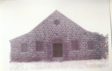
Document, F. S. Baker Real Estate Agent, 1950
F. S. Baker Real Estate Agent business booksA collection of business booksnon-fictionF. S. Baker Real Estate Agent business booksbaker f s, real estate agents -
 Kew Historical Society Inc
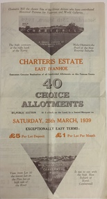
Plan - Subdivision Plan, Charteris Estate, East Ivanhoe, 1939
The Charteris Estate in Ivanhoe was sold in a number of sections. Copies of a subdivision plan of the first section is in the State Library of Victoria collection. This later section of the Charteris Estate includes lots in the Government Boulevard, Castella Street, McArthur Road, Burke Road North, Charteris Drive and Warncliff Road.Subdivision plans like that for the Charteris Estate are invaluable records for local historians identifying when lots in streets were promoted for sale.Four-fold brochure advertising the Charteris Estate in East Ivanhoe in 1939. Streets named on the plan include: the Government Boulevard, Castella Street, McArthur Road, Burke Road North, Charteris Drive and Warncliff Road. The brochure contains photos of Charterisville, the home of F De Castella Esq and also of attractive rolling hills. Annotations in pencilcharteris estate - east ivanhoe (vic), subdivision plans - east ivanhoe (vic) -
 Kew Historical Society Inc
Plan - Subdivision Plan, Charteris Estate, East Ivanhoe, 1939
The Charteris Estate in Ivanhoe was sold in a number of sections. Copies of a subdivision plan of the first section is in the State Library of Victoria collection. This later section of the Charteris Estate includes lots in the Government Boulevard, Castella Street, McArthur Road, Burke Road North, Charteris Drive and Warncliff Road.Subdivision plans like that for the Charteris Estate are invaluable records for local historians identifying when lots in streets were promoted for sale.Four-fold brochure advertising the Charteris Estate in East Ivanhoe in 1939. Streets named on the plan include: the Government Boulevard, Castella Street, McArthur Road, Burke Road North, Charteris Drive and Warncliff Road. The brochure contains photos of Charterisville, the home of F De Castella Esq and also of attractive rolling hills. Annotations in pencilcharteris estate - east ivanhoe (vic), subdivision plans - east ivanhoe (vic) -
 Wonga Park Community Cottage History Group
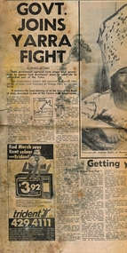
Newspaper (Item) - Cutting, Wonga Park: Herald newspaper cutting 16/9/1972 Govt Joins Yarra Fight
State Government agencies have joined local government to oppose lan developers' plans to subdivide an untouched pat of the Yarra. The subdivision involves 565 hectares (Yarra Brae and Stane Brae) and more than 16 kms of bush river frontage at Wonga Park in Lillydale Shire -
 Tarnagulla History Archive
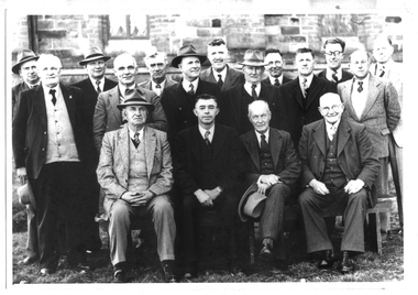
Photograph of Shire of Bet Bet Council, 1952, Shire of Bet Bet Council, 1952, 1952
Murray Comrie Collection. Shire of Bet Bet Proclaimed Sept 20, 1864 Re-defined Feb 10, 1891 Tarnagulla Borough united Oct 1915 Dunolly Borough united Nov 1, 1921 Re subdivision from 5 to 3 ridings Oct 1952Monochrome photograph of a group of men assembled in rows for a photograph. Accompanied by a handwritten note (catalogued separately as a Research Note) with subjects' names. Names of subjects from accompanying note (handwriting difficult to decipher) are believed to be: Left to Right Back/3rd row: Cr J. Grogan, A. Whitehead, G. Barman, J.B. Reid, I.R. Stevens (?), KAG Lowe (Shire Sec), Mr A Rescott (Maryborough Advertiser) Middle row: Crs N.K. Conera (Pres. Elect), D.E. Wood, A. Brownbill, J.P. Mason, D. Clark, K.R. Culleton (Shire Engineer). Front/1st row: Crs G. Fotheringham, J. Fremantle (1951-52), A. Green, J. Hickey. Note also states: 'Secretary Lowe passed away Sept 7, 1952' and 'Fotheringham House, Glenferrie' (location where photograph taken?)tarnagulla, council, bet bet shire, local government, councillors, mayor, shire, engineer, maryborough advertiser, reid, grogan, whitehead, barman, stevens, lowe, rescott, conera, wood, brownbill, mason, clark, culleton, fotheringham, fremantle, green, hickey -
 Tarnagulla History Archive
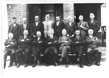
Photograph of Shire of Bet Bet Council, 1935, Shire of Bet Bet Council, 1935, 1935
Murray Comrie Collection. Shire of Bet Bet Proclaimed Sept 20, 1864 Re-defined Feb 10, 1891 Tarnagulla Borough united Oct 1915 Dunolly Borough united Nov 1, 1921 Re subdivision from 5 to 3 ridings Oct 1952Monochrome photograph of a group of men assembled in rows for a photograph. Accompanied by a handwritten note (catalogued separately as a Research Note) with three of the subjects' names. Text from accompanying note (handwriting difficult to decipher): With compliments A. Green (Pres) 3 I know: Geo F., J.B. Reid Don Calder tarnagulla, council, bet bet shire, local government, councillors, mayor, shire, reid, calder -
 Otway Districts Historical Society
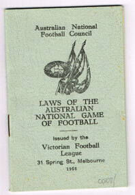
Booklet, Victorian Football League, Australian National Football Council. Laws of the Australian National Game of Football, 1956
The 1956 laws of the national game of Australian football are reasonably brief covering only 33 rules with a maximum of eight subdivisions of each. As well as the Australian National Football Council and its affiliated bodies, it spells out the rules of the game, definitions of the laws, and an outline of the positions and plan of the playing field.Laws of the Australian National Game of Football. Australian National Football Council. Victorian Football League; Melbourne (Vic); 1956. i, 40 p.; map. Soft cover.australian national football council; football; laws; playing field; definitions; affiliated bodies; -
 Bendigo Historical Society Inc.
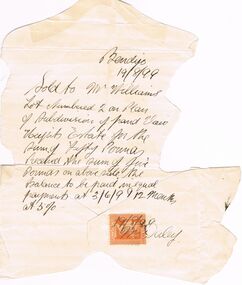
Document - OWEN WILLIAMS COLLECTION: VIEW HEIGHTS ESTATE LAND SALE NOTE, 03/06/99
Document. The Owen Williams collection. Land Sale Note for View Heights Estate Bendigo. Sold to Mr Williams’s lot numbered 2 on plan of Subdivision of land View Heights Estate for the sum of fifty Pounds. Balance to be paid in equal payments at 03/06/99 and 12 months at 5%. It has a one penny orange duty stamp at the bottom with 19/08/99 and Mr Daley written on.bendigo, land sales, view heights estate, owen williams & co. -
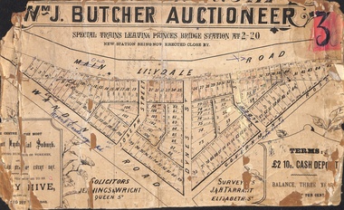 Ringwood and District Historical Society
Poster - Land Sale, Wm J. Butcher, Auctioneer - Albert Park Estate, Ringwood - c.1890
Central section of land sale subdivision advertisement glued to heavy cardboard backing. Photocopied SLV image of original advertisement shows map of 117 allotments for sale in Main Lilydale Road (later Old Lilydale Road), Wandin Road (later Mount Dandenong Road), Joseph Street, Dynes Street, Albert Street (later Wyrunga Street) and Government Road (later Carcoola Road), Ringwood East.Solicitors - Jenningw & Wright, Queen Street. Surveyors - J.&H. Tarrant, Elizabeth Street. Terms £2 10s cash deposit, balance three years at six per cent. -
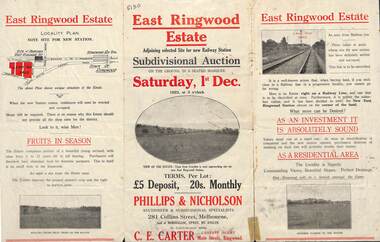 Ringwood and District Historical Society
Flyer, Subdivisional Auction Sale Brochure, East Ringwood Estate, Vic. - 1923
Tri-folded double sided advertisement for subdivisional auction sale on Saturday, 1st December, 1923, including location map and summary of local facilities and services.Subdivision includes Patterson Street, Bona Street, Miller Grove, Fairview Avenue and Eastfield Road. Auctioneer - Phillips & Nicholson, 281 Collins Street, Melbourne. Tel. Central 10907. Agent - C.E. Carter, Main Street, Ringwood. Tel. Ringwood 24. -
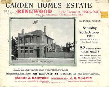 Ringwood and District Historical Society
Flyer, Subdivisional Land Auction Sale Brochure, Garden Homes Estate, Ringwood, Vic. - 1923
Double sided multi-folded page advertising auction sale of residential allotments highlighting local facilities, services and layout of the estate. Includes panoramic view of Ringwood and other local photographic images.Subdivision includes Mullum Mullum Road, The Centreway, Wattle Crescent and Reserve Crescent. Agents - Knight & Harwood, 315 Collins Street, Melbourne, Phone 10615, 10616 Central, in conjunction with J.B. McAlpin, Opposite Railway Station, Ringwood. Phone Ringwood 7. -
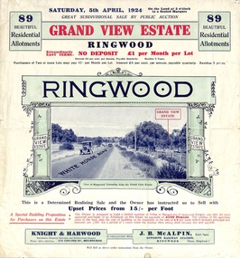 Ringwood and District Historical Society
Flyer, Subdivisional Land Auction Sale Brochure, Grand Central Estate, Ringwood, Vic. - 1924
Refer also to Reg. No. 5148 for 1925 auction sale of land also titled Grand View Estate situated further south in Ringwood.Double sided multi-folded page advertising public auction sale on Saturday, 5th April, 1924, of residential allotments highlighting local facilities, services and layout of the estate. Includes panoramic view over the estate and other local photographic images.Subdivision includes Whitehorse Road, Rupert Street, Herbert Street. and Leonard Street. Agents - Knight & Harwood, 315 Collins Street, Melbourne, Phone 10615, 10616 Central, in conjunction with J.B. McAlpin, Opposite Railway Station, Ringwood. Phone Ringwood 7. -
 Ringwood and District Historical Society
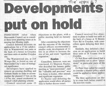
Newspaper, Scrapbook Clipping, Library Collection, Ringwood, Victoria
Newspaper Clipping from "The Post", 10-3-1998. 79. Dvelopments put on holdMaroondah Coincil sat to consider three town planning issues at its meeting last Monday night. Council deferred decisions on applications for a 17 lot subdivision in Warranwood; two units at the back of a house in Croydon and three units at another Croydon site. -
 Eltham District Historical Society Inc
Document - Folder, Bridgeland Estate, Eltham South, 1998
Various documents, including a history, letter and reminscences relating to properties of the Bridgeland Estate including Antoinette Boulevard and Leonard Crescent, Eltham South. 5 photocopies of parts of maps relating to subdivisions from 1842 to the 1925 Bridgland Park Estate Folders 78 and 80 from Harry Gilham Collection 12 pagesantoinette boulevard, leonard crescent, eltham south, bridgeland park estate, harry gilham collection -
 Melton City Libraries
Photograph, West Melton-Coburns Road, 1969
Coburns Road - 19th c family descendents living in Melton. Coburn Primary School Cr George Coburn. 1930’s. December 1935 Shire President Cr Geo Coburn convened meeting to form the Bush Fire Brigade. Road construction of Service road and beginnings of West Melton subdivision. West Melton-Early Division View of Coburns Road. council, local significant events -
 Bacchus Marsh & District Historical Society
Map, Coimadai Parish Map, County of Bourke. Circa 1890s-1900s
The cadastral Parish of Coimadai, a subdivision of the County of Bourke, lies directly north of the township of Bacchus Marsh. The date of this map is uncertain. T.F. McGauran the person who made a photo-lithographic copy of the map was in charge of photo-lithography at the Victorian Department of Lands and Survey in the late 19th century until about 1910.A single page paper map showing the map for the Parish of Coimadai in the County of Bourke. A cadastral map showing parish boundaries and land ownership. A rectangle shaped area is missing from the centre of the map due to a tear or deliberate excision. The map is pasted into a bound volume containing 76 maps or plans in total. High resolution digital image stored on BMDHS computer network. Photo-lithographed at the Department of Lands and Survey, Melbourne by T.F. McGauran 26.8.[??] NOTE. Photo litho from L.P showing temporary surveys and occupation of land prepared for departmental use onlybacchus marsh region parish plans, coimadai parish maps, coimadai parish plan -
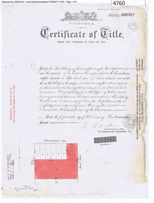
 Ringwood and District Historical Society
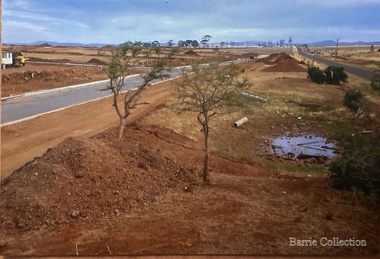
Document, Certificate of Title - Mary Burchett, Lilydale Road, Ringwood - part of Crown Section 20, Parish of Warrandyte, County of Evelyn - 5th July, 1911
A4 copies of Landata Victoria Historical Search documents - Vol 3520 Fol 703990.Mary Burchett of Ringwood, Married Woman, is now the proprietor of an Estate in Fee-simple subject to the Encumbrances notified hereunder ... 50 acres 1 rood 32 perches or thereabouts, being lots 1 and 10 on plan of subdivision no.4315. Subdivision map includes un-named roads - western side is Wonga Road (later Warranwood Road), and eastern side is Grandview Grove (later Bemboka Road), both north of Plymouth Road, Ringwood, Vic. Title transferred to Theodore Hartley Burchett, 27th July, 1911. Encumbrance comment "Special railway condition contained in Grant to Francis Cooke." -
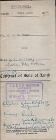 Bendigo Historical Society Inc.
Document - H.A. & S.R. WILKINSON COLLECTION: CONDITION OF SALE
Contract of sale of land dated 23rd June, 1952 between Mr. J.L.C. Hunt (seller) and Miss D.A. Phillips for land being Lot 18 on plan of subdivision No. 14194, being part of Crown allotments 454A and 476 section H described in certificate of title volume 6110, folio 975 situate in Murray Street, Bendigo, together with 50roomed weatherboard dwelling and all sundry. Price 2,525 pounds.organization, business, h.a. & s.r wilkinson real estate -
 Kew Historical Society Inc
Plan, Gwen McWilliam, Annotated Plan of City of Boroondara, c.1995
Gwen Barton McWilliam (nee: Nelson), OAM, BA (1933- ). Gwen McWilliam is well known as an authority on the history of Boroondara and the author of a large number of books and pamphlets about the City. She was awarded the medal of the Order of Australia in 2001 ‘for service to the community of Hawthorn and district, particularly through the research, documentation and publication of its history.’ Digitally annotated part plan of the City of Boroondara, created by Council (Library?) staff, based on annotated plans provided by the historian Gwen McWilliam, identifying significant landholdings, subdivisions and key dates. On the plan Gwen McWilliam noted that the attempt to copy her annotations had resulted in incorrect data being included, so the plans were never published. For plans including her original 1993 annotations, see 2017.0143 and 2017.0144.Council markings in pinksubdivisions - hawthorn, subdivisions - kew, subdivisions - camberwell, subdivisions - balwyn, subdivisions - surrey hills, subdivisions - canterbury, gwen mcwilliam -
 Kew Historical Society Inc
Plan, Gwen McWilliam, Annotated Plan of City of Boroondara, c.1995
Gwen Barton McWilliam (nee: Nelson), OAM, BA (1933- ). Gwen McWilliam is well known as an authority on the history of Boroondara and the author of a large number of books and pamphlets about the City. She was awarded the medal of the Order of Australia in 2001 ‘for service to the community of Hawthorn and district, particularly through the research, documentation and publication of its history.’ Digitally annotated part plan of the City of Boroondara, created by Council (Library?) staff, based on annotated plans provided by the historian Gwen McWilliam, identifying significant landholdings, subdivisions and key dates. On the plan Gwen McWilliam noted that the attempt to copy her annotations had resulted in incorrect data being included, so the plans were never published. For plans including her original 1993 annotations, see 2017.0143 and 2017.0144.Council additions in pinksubdivisions - hawthorn, subdivisions - kew, subdivisions - camberwell, subdivisions - balwyn, subdivisions - surrey hills, subdivisions - canterbury, gwen mcwilliam -
 Kew Historical Society Inc
Plan, Gwen McWilliam, Annotated Plan of City of Boroondara, c.1995
Gwen Barton McWilliam (nee: Nelson), OAM, BA (1933- ). Gwen McWilliam is well known as an authority on the history of Boroondara and the author of a large number of books and pamphlets about the City. She was awarded the medal of the Order of Australia in 2001 ‘for service to the community of Hawthorn and district, particularly through the research, documentation and publication of its history.’ Digitally annotated part plan of the City of Boroondara, created by Council (Library?) staff, based on annotated plans provided by the historian Gwen McWilliam, identifying significant landholdings, subdivisions and key dates. On the plan Gwen McWilliam noted that the attempt to copy her annotations had resulted in incorrect data being included, so the plans were never published. For plans including her original 1993 annotations, see 2017.0143 and 2017.0144.Additions in pink by City of Boroondarasubdivisions - hawthorn, subdivisions - kew, subdivisions - camberwell, subdivisions - balwyn, subdivisions - surrey hills, subdivisions - canterbury, gwen mcwilliam -
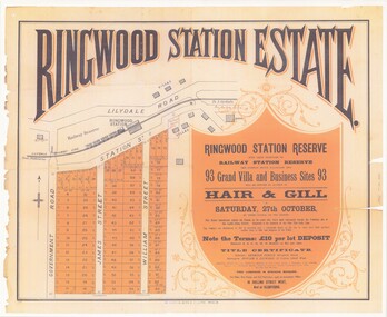 Ringwood and District Historical Society
Poster - Auction, Ringwood Station Estate, Ringwood, Victoria - circa 1925
Colour photocopy of poster sub-titled Ringwood Station Reserve & Railway Station Reserve. Auction of 93 sites on Saturday 27th October (no year, likely 1925). Subdivision includes Station Street, Government Road (Wantirna Road), James Street, William Street. Auctioneers - Hair & Gill, 16 Collins Street West and Glenferrie. Solicitor - Seymour Fergie, Elizabeth Street. Surveyors - Fowler & Gatward, 12 Collins Street West. -
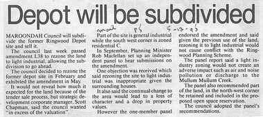 Ringwood and District Historical Society
Newspaper, Scrapbook Clipping, Library Collection, Ringwood, Victoria, `
``Newspaper clipping from "The Mail"5-12-95", P 5. Depopt will be subdivided. Maroondah Council will subdivide the former Ringwood Depot site and sell it. The council last week passed amendment 1.38 to rezone the land to light industrial, allowing the subdivision to go ahead. It would not reveal how much it expected for the land because of the tender sale process.` -
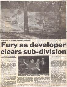 Ringwood and District Historical Society
Newspaper, Scrapbook Clipping, Library Collection, Ringwood, Victoria
Newspaper Clipping from "The Mail", 25-7-95. P3. Fury as developer clears sub-division. By Leonora Elliot-BruceConcerned conservationists have accused a developer of almost destroying vegetation to make way for a North Ringwood subdivision. The group, Friends of Loughie's Bushland, wants Maroondah City Council to investigate the developer's action which it claims has devastated the area. The developers are Barnsdale Forest -
 Greensborough Historical Society
Certificate of Title, Certificate of Title Vol. 3182 Fol. 302, 15/02/1907
Title in the name of Joseph Laidlay of Greensborough, fruitgrower, 14 acres being Lots 7, 8 and 22 on Plan of subdivision 4759, part of Crown portion 17, Parish of Keelbundora County of Bourke, dated 15th February 1907. Northern boundary Greensborough (now Grimshaw) Road, Eastern boundary Henry Street.1 p. colour copy of Titlegreensborough, grimshaw street greensborough, henry street greensborough, joseph laidlay -
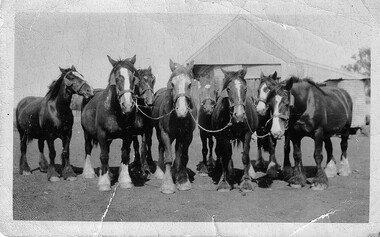 Hymettus Cottage & Garden Ballarat
Photograph, Archie Burke's Ploughing Team Dooboobetic
Mr William Burke settled at Dooboobetic near Donald in the 1860s his sons eventually working their own farms on subdivisions of the original property. Archibald (Archie) whose team is pictured had a portion named "Inverleigh". His daughter married Mr Michael Taffe of "Hymettus" Ballarat where the photographic archive survives. small snapshot image badly creased of team with inscription and print on reverse.Written on reverse "G'pa Burke's team. with printed words KODAK PRINT and ink stamp 431 -
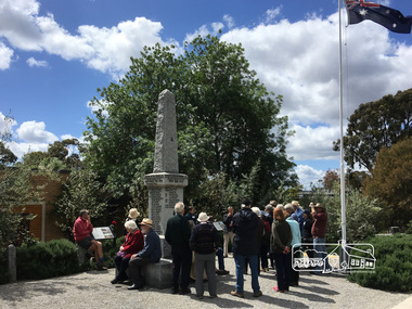 Eltham District Historical Society Inc
Photograph, Peter Pidgeon, Eltham War Memorial, 903-907 Main Road, Eltham, 4 November 2017, 4 Nov 2017
Eltham District Historical Society heritage walk to follow the boundaries of the original Shillinglaw Farm in central Eltham, held Saturday, 4th November, 2017. The Shillinglaw Farm comprised Lot 90 of Holloway’s 1851 Little Eltham subdivision. It was originally 30 acres in area and situated east of the Diamond Creek and north of Henry Street.Born digital imageeltham war memorial, obelisk, war memorial buidings, war memorial hall