Showing 848 items
matching surveyors
-
 Eltham District Historical Society Inc
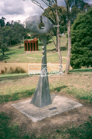
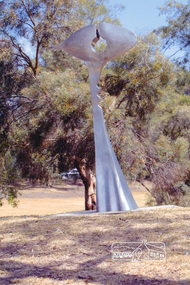
Slide - Photograph, Sculpture, Surveyor of Suburban Environs, Ernst Fries (1991), Alistair Knox Park, cnr Bridge Street and Main Road, Eltham, c.1993
35mm colour positive transparency Mount - Black and Whitealistair knox park, art in public places, classical-landscape (1996), cliff burtt, public art, sculptures, surveyor of suburban environs (1991) -
 Eltham District Historical Society Inc
Slide - Photograph, Surveyor of Suburban Environs, Ernst Fries (1991), Alistair Knox Park, Eltham, c.Nov. 2001
Part of a slide show presentation "A Trip Down the Diamond Creek" by Russell Yeoman to the Eltham District Historical Society meeting of 14 Nov. 200135mm colour positive transparency Mount - Black and Whiteeltham, alistair knox park, art in public places, ernst fries, public art, surveyor of suburban environs (1991) -
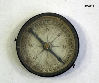 Bendigo Military Museum
Equipment - COMPASS, PROTRACTOR, RULER, Est WWI
The 3 items belonged to Sgt Jack Grinton No 1043, 38th Batt AIF. The ruler was broken by a small piece of shrapnel which then passed through a wallet containing photos. Refer Cat No 1280 for service details. Refer 1317P, 1320P, 1241.22P, 1278.2. Part of the Grinton collection which included hundreds of negatives and developed photos that he took during the War..1) Pocket compass, metal and glass, mirror backed. .2) Protractor-wooden, metal stud and ring. .3) Ruler, wood, in 2 parts..2) "Veare wood" .3) One inch and centimetre increments.instruments-measuring, surveyors-terrestrial -
 Federation University Historical Collection
Book - Book - Scrapbook, Ballarat School of MInes: Scrapbook of Newspaper Cuttings, Book 4, March 1978 - February 1979
Collection of newspaper articles related to Ballarat School Of Mines.They cover activities and advertisements for staff. The papers concerned are The Courier, Ballarat, The Australian, The Age over the period of 2 March 1978 to 7 February 1979.Book with deep red and white cover back and front, spiral bound. staffing advertisements, norton villiers motor presented to smb, british student counsellor visits smb, far-reaching consequences says barker, engineers and surveyors plan new courses, first technical college in australia, historic timetable, physical education students, canoe trip down glenelg river, complex opened -regional education offices, rex hollioake new president of smb council, director of mount isa mines smb student, john middlin, school began with gold -
 Mission to Seafarers Victoria
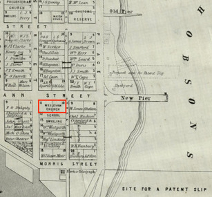
Map, Surveyor General's Office, Plan of Williamstown, County of Bourke, 20 November 1855
Plan of Williamstown in 1855The map helps locate the Wesleyan church on Ann Street which was converted in the Sailors' Rest in 1875.ann street, wesleyan church, sailors' rest, williamstown -
 Kiewa Valley Historical Society
Postcard Circa 1950, Lake Guy Dam and Bogong Village, Circa 1950
This postcard was produced in the 1950's for the tourist trade in the Kiewa Valley and Alpine region. It encompasses the period when the State of Victoria was pressured by the ever increasing demand by industry and its population for electricity supplies. Hydro electricity was seen as an untapped natural resource to quench this demand. The Victorian Alps and the rivers flowing into its valleys was ideal for the construction of the Kiewa Hydro Electricity Scheme. The late 1940's saw the development of this scheme and the changing of sections of alpine landscape is covered by this and other postcards/pictures (tourists, construction workers, and established rural populations). This period in time was before the established wildlife and forest/nature groups became political activist who changed legislative acts to protect the environment.This rural region (Kiewa Valley/alpine plains) was at most only significant to a smaller group of winter sports, summer hikers/horse riders and rural farmers/graziers. The numbers of tourists and the increase in the local resident population was boosted by the construction of the Hydro Electricity Scheme. This influx to the regional population resulted in a corresponding diversity in services and brought about an environment that responded to a growing level of tourists and thereby permitting this industry to grow more rapidly than it would have naturally. This postcard details an attraction to the "cleaner" method of providing electricity. This postcard was purchased in 1950 by a surveyor at Landford's Gap.This black and white photograph from a Valentine's postcard is from a V2 Argus photograph postcard. It is on a 200g/m paper density photo side gloss. See 0480 (B) - (F) for other photos of similar postcards.In white lettering " LAKE GUY & BOGONG VILLAGE KIEWA HYDRO-ELECTRIC PROJECT"kiewa valley tourism, victorian alps, alternate energy supplies, alpine population growth -
 Kiewa Valley Historical Society
Postcard Circa 1950, Snowfall at Bogong Village Kiewa Hydro-Electric Project, 1950s
This postcard was produced in the 1950's for the tourist trade in the Kiewa Valley and Alpine region. It encompasses the period when the State of Victoria was pressured by the ever increasing demand by industry and its population for electricity supplies. Hydro electricity was seen as an untapped natural resource to quench this demand. The Victorian Alps and the rivers flowing into its valleys was ideal for the construction of the Kiewa Hydro Electricity Scheme. The late 1940's saw the development of this scheme and the changing of sections of alpine landscape is covered by this and other postcards/pictures (tourists, construction workers, and established rural populations). This period in time was before the established wildlife and forest/nature groups became political activist who changed legislative acts to protect the environment.This rural region (Kiewa Valley/alpine plains) was at most only significant to a smaller group of winter sports, summer hikers/horse riders and rural farmers/graziers. The numbers of tourists and the increase in the local resident population was boosted by the construction of the Hydro Electricity Scheme. This influx to the regional population resulted in a corresponding diversity in services and brought about an environment that responded to a growing level of tourists and thereby permitting this industry to grow more rapidly than it would have naturally. This postcard details an attraction to the "cleaner" method of providing electricity. This postcard was purchased in 1950 by a surveyor at Landford's Gap.This scanned black and white photograph of a postcard, shows vehicles covered in thick snow at Bogong Village in 1950. See 0480(A), (C) - (F) for other similar photos of postcards available at this period."SNOWFALL AT BOGONG VILLAGE KIEWA HYDRO-ELECTRICITY PROJECT"kiewa valley tourism, victorian alps, alternate energy supplies, alpine population growth, bogong village, secv -
 Kiewa Valley Historical Society
Postcard Circa 1950, Scene in Bogong Village Kiewa Hydro-Electric Project, 1950s
This postcard was produced in the 1950's for the tourist trade in the Kiewa Valley and Alpine region. It encompasses the period when the State of Victoria was pressured by the ever increasing demand by industry and its population for electricity supplies. Hydro electricity was seen as an untapped natural resource to quench this demand. The Victorian Alps and the rivers flowing into its valleys was ideal for the construction of the Kiewa Hydro Electricity Scheme. The late 1940's saw the development of this scheme and the changing of sections of alpine landscape is covered by this and other postcards/pictures (tourists, construction workers, and established rural populations). This period in time was before the established wildlife and forest/nature groups became political activist who changed legislative acts to protect the environment. This rural region (Kiewa Valley/alpine plains) was at most only significant to a smaller group of winter sports, summer hikers/horse riders and rural farmers/graziers. The numbers of tourists and the increase in the local resident population was boosted by the construction of the Hydro Electricity Scheme. This influx to the regional population resulted in a corresponding diversity in services and brought about an environment that responded to a growing level of tourists and thereby permitting this industry to grow more rapidly than it would have naturally. This postcard details an attraction to the "cleaner" method of providing electricity. This postcard was purchased in 1950 by a surveyor at Landford's Gap. The couple shown in this photograph would have been employed by the S.E.C. under the Kiewa Hydro-Electricity Scheme.This item is a scanned black and white photograph of a couple walking along a gravel street in Bogong Village in 1950. See 0480 (A) ,(B), (D) - (F) for other photos of similar postcards" SCENE IN BOGONG VILLAGE KIEWA HYDRO-ELECTRIC PROJECT"kiewa valley tourism, victorian alps, alternate energy supplies, alpine population growth, bogong, secv -
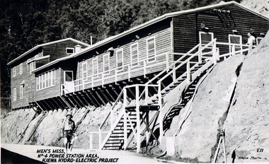 Kiewa Valley Historical Society
Postcard Circa 1950, Men's Mess No.4 Power Station, Kiewa Hydro-Electric Project
This postcard was produced in the 1950's for the tourist trade in the Kiewa Valley and Alpine region. It encompasses the period when the State of Victoria was pressured by the ever increasing demand by industry and its population for electricity supplies. Hydro electricity was seen as an untapped natural resource to quench this demand. The Victorian Alps and the rivers flowing into its valleys was ideal for the construction of the Kiewa Hydro Electricity Scheme. The late 1940's saw the development of this scheme and the changing of sections of alpine landscape is covered by this and other postcards/pictures (tourists, construction workers, and established rural populations). This period in time was before the established wildlife and forest/nature groups became political activist who changed legislative acts to protect the environment.Although this photo details the eating facilities of the construction workers at the power station it was not only a postcard for the people employed in the Hydro Scheme is was also provided to tourists visiting the area and thus used for promotional purposes.This rural region (Kiewa Valley/alpine plains) was at most only significant to a smaller group of winter sports, summer hikers/horse riders and rural farmers/graziers. The numbers of tourists and the increase in the local resident population was boosted by the construction of the Hydro Electricity Scheme. This influx to the regional population resulted in a corresponding diversity in services and brought about an environment that responded to a growing level of tourists and thereby permitting this industry to grow more rapidly than it would have naturally. This postcard details an attraction to the "cleaner" method of providing electricity. This postcard was purchased in 1950 by a surveyor at Landford's Gap. The men shown in this photograph would have been employed by the S.E.C. under the Kiewa Hydro-Electricity Scheme.This item is a scanned black and white photograph of a construction worker walking from stairs leading down from the men's mess building, in 1950. See 0480 (A) -(C), (E) - (F) for other photos of similar postcards"MEN'S MESS No.4 POWER STATION AREA, KIEWA HYDRO-ELECTRIC PROJECT" "ARGUS PHOTO V.IIkiewa valley tourism, victorian alps, alternate energy supplies, alpine population growth, secv -
 Kiewa Valley Historical Society
Postcard Circa 1950, Mt. Beauty Village, Kiewa Hydro-Electricity Project, circa 1950
This postcard was produced in the 1950's for the tourist trade in the Kiewa Valley and Alpine region. It encompasses the period when the State of Victoria was pressured by the ever increasing demand by industry and its population for electricity supplies. Hydro electricity was seen as an untapped natural resource to quench this demand. The Victorian Alps and the rivers flowing into its valleys was ideal for the construction of the Kiewa Hydro Electricity Scheme. The late 1940's saw the development of this scheme and the changing of sections of alpine landscape is covered by this and other postcards/pictures (tourists, construction workers, and established rural populations). This period in time was before the established wildlife and forest/nature groups became political activist who changed legislative acts to protect the environment. The regulatory pondage on the northern aspect of the village had no water over-spill from the unfinished power station.This rural region in 1950 (Kiewa Valley/alpine plains) was at most only significant to a smaller group of winter sports, summer hikers/horse riders and rural farmers/graziers. The numbers of tourists and the increase in the local resident population was boosted by the construction of the Hydro Electricity Scheme. This influx to the regional population resulted in a corresponding diversity in services and brought about an environment that responded to a growing level of tourists and thereby permitting this industry to grow more rapidly than it would have naturally. This postcard details an attraction to the "cleaner" method of providing electricity. This postcard was purchased in 1950 by a surveyor at Landford's Gap. The couple shown in this photograph would have been employed by the S.E.C. under the Kiewa Hydro-Electricity Scheme.This item is a scanned black and white photograph of a panoramic view of Mount Beauty Village in 1950 (a closed village, entry by pass only). The regulatory pondage has earthen walls but no water.See 0480 (A) -(D) and (F) for other photos of similar postcards"MT. BEAUTY VILLAGE KIEWA HYDRO-ELECTRIC PROJECT"kiewa valley tourism, victorian alps, alternate energy supplies, alpine population growth -
 Kiewa Valley Historical Society
Postcard Circa 1950, Howman Gap Hostel under snow Kiewa Hydro-Electric Project, Circa 1950
This postcard was produced in the 1950's for the tourist trade in the Kiewa Valley and Alpine region. It encompasses the period when the State of Victoria was pressured by the ever increasing demand by industry and its population for electricity supplies. Hydro electricity was seen as an untapped natural resource to quench this demand. The Victorian Alps and the rivers flowing into its valleys was ideal for the construction of the Kiewa Hydro Electricity Scheme. The late 1940's saw the development of this scheme and the changing of sections of alpine landscape is covered by this and other postcards/pictures (tourists, construction workers, and established rural populations). This period in time was before the established wildlife and forest/nature groups became political activist who changed legislative acts to protect the environment.This rural region (Kiewa Valley/alpine plains) was at most only significant to a smaller group of winter sports, summer hikers/horse riders and rural farmers/graziers. The numbers of tourists and the increase in the local resident population was boosted by the construction of the Hydro Electricity Scheme. This influx to the regional population resulted in a corresponding diversity in services and brought about an environment that responded to a growing level of tourists and thereby permitting this industry to grow more rapidly than it would have naturally. This postcard details an attraction to the "cleaner" method of providing electricity. This postcard was purchased in 1950 by a surveyor at Landford's Gap.This item is a scanned black and white photograph of a panoramic view of Howman Gap Hostel under snow in 1950 (a closed village, entry by pass only). This accommodation was for construction workers only. See 0480 (A) -(E) for other photos of similar postcards.On the photo, " Howman Gap Hostel under snow Kiewa Hydro-Electric Project" . On postcard address and personal information side "V.2 Valentine's Post Card "kiewa valley tourism, victorian alps, alternate energy supplies, alpine population growth, bogong, secv, howman's gap hostel -
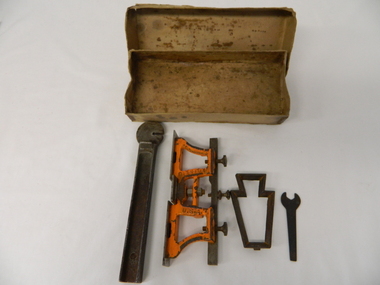 Kiewa Valley Historical Society
Spanner Small, 1920's
This spanner, part of a raker/jointer/guage set which is a sharpening tool for cross cut logging saws. The logging saws used in the early 1900's for the clearing of forests required constant sharpening of their "cutting teeth". The logging of forested areas during these times was very much a "hands on" method of either one or two men by the use of saw or hand axe. Chain saws, chain and ball(clearing) and bulldozing methods came in the mid 1900's.This particular spanner was part of a crosscut saw sharpening tool and method was used by surveyors laying down boundaries for the S.E.C. Victoria Hydro Electricity Scheme (1920's). This item was given to a local Kiewa Valley lad who accompanied the initial surveyors. The lad was responsible for the tendering and feeding of the surveyors "pack horses". Surveys during this period and in the dense mountainous terrain of the Victorian Alps was both exhausting and hazardous. Overnight accommodation at various log cabins was not always possible and swag/tent alternative was the "fall back"This small spanner is part of the Raker/Jointer Gauge saw set and is made from forged steel. The nut grip is of the two tightening nuts on the main construction frame. See KVHS 0090 (A &B) for the other items making up the sharpening tools.hand tool, saw, sharpening method, tree felling. -
 Eltham District Historical Society Inc
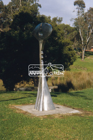
Photograph, Surveyor of Suburban Environs, Ernst Fries (1991), Alistair Knox Park, Eltham, March 2004, 2004
Colour photographeltham, alistair knox park, art, sculptures, ernst fries, surveyor of suburban environs (1991) -
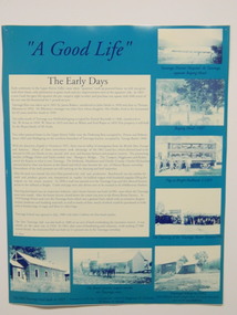 Kiewa Valley Historical Society
Posters - 9 in the Set, The Famous Bogong School, Beyond the Gate-(up and down) , A Good Life, The Precursors, Great Expectations, Windows to Yesterday, c1998
These posters were produced for a display during the Mt Beauty Music Festival in 1998. They cover the history of the Kiewa Valley from the early days, farming and the Kiewa Hydro Electric Scheme. These posters summarise the history of the Kiewa Valley and were compiled using memories, publications and documents. The posters are clear and useful for display.Large glossy cardboard posters: Mostly blue and white with photos and writing of the history of different aspects of the Kiewa Valley 1. Bogong School 2. Bogong Village 3. Mt Beauty 4. Tawonga 5. The Early Years 6. Kiewa Hydro Story 7. The Kiewa Valley Runs 8 & 9. Cattlemen & Huts of High Plains. Created for display with sources sighted. See KVHS 0956 bogong state school. bogong village. state electricity commission of victoria. tawonga. surveyors. mt beauty. camps. kiewa hydro electric scheme. kiewa valley. -
 Kiewa Valley Historical Society
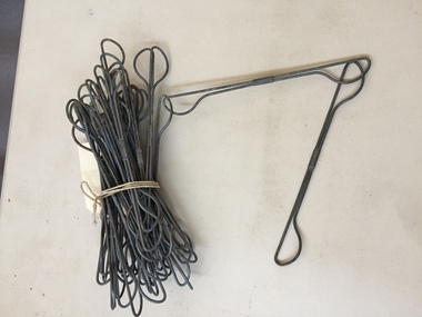
Surveyors Chain
See KVHS 1651A bundle of galvanised wire chains linked at each end to form a chain. Each link is 9 inches long. See KVHS 1651 -
 Flagstaff Hill Maritime Museum and Village
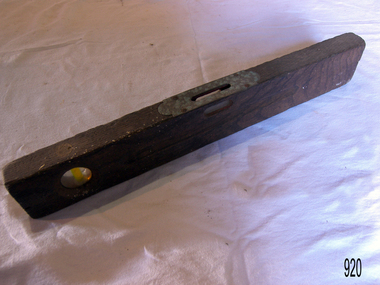
Tool - Spirit level, Early to mid-20th century
The tool is used for establishing a horizontal plane, it consists of a small glass tube containing alcohol or similar liquid and an air bubble. The tube is sealed and fixed horizontally in a wooden or metallic block or frame with a smooth lower surface. The glass tube is slightly bowed, and adjustment to the horizontal is indicated by the movement of the bubble. The device is on a level surface when the bubble is in the middle of the glass tube. The level sensitivity is proportional to the radius of the curvature of the glass. The spirit or bubble level consists of a sealed glass tube containing alcohol and an air bubble. It was invented in 1661 and was first used on telescopes and later on surveying instruments, but it did not become a carpenter's tool until the factory-made models were introduced in the mid-19th century. The circular level, in which a bubble floated under a circular glass to indicate the level in all directions, was invented in 1777. But It lacked the sensitivity of the conventional level.A hand tool that has not changed much since its invention in 1661, this tool is used today and although the materials it is made from have changed it's use has not.Spirit level wooden with two windows one of which has a piece of brass sheet metal protecting it.Noneflagstaff hill, warrnambool, flagstaff-hill, flagstaff-hill-maritime-museum, maritime-museum, shipwreck-coast, flagstaff-hill-maritime-village, hand tool, spirit level, carpenders tool, builders tool, surveyors instrument -
Glen Eira Historical Society
Ephemera - ROSENEATH, NEPEAN HIGHWAY, 31, ELSTERNWICK
This file contains 8 pages and one property notice. The file contains: 1/descriptions from Andrew Ward’s Heritage Planning Report. Notes on residents of ‘Roseneath’ from 1866 to 1963. Articles include household goods sale, public notices, wills and estate notices from Trove and census record. Details from Ancestry.com 2016. 2/Property sale notice of ‘Roseneath’ dated 04/03/2016 from Leader newspaper.‘roseneath’, house names, point nepean road, elsternwick, bogle andrew esq., auctions, wragge william, wragge mary, wragge william charles, miller william, councillors, rusden street, mcmillan street, subdivision, boyle andrew, merchants, shire of caulfield, east st kilda riding, breckinhill lodge, bogle andrew mrs., wragge w mrs, st kilda cemetery, cemeteries, kirkham councillor, long councillor, riddell councillor, lempriere councillor, ilberry concillor, worthington george, judges, tulloch annie, st kilda ladies benevolent society, worthington mrs, wheeldon isaac, tulloch w.g., breweries, elsternwick, madame berry west company, tulloch and son, mccracken’s brewery, elsternwick station, ‘elderslie’, glenhuntly road, wheeldon sarah, cross anastacia, brick houses, meek alexander charles, meek una eveline, meek david, meek jane, meek james, meek alexander, meek kathleen, meek william, lloyd i. captain, lloyd mary, lloyd nova, lloyd eileen, meek anastasia mary, meek william john, meek monica venus, engineers, marine surveyors, social events and activities, wills and estates, real estate, advertisements -
Glen Eira Historical Society
Ephemera - Orion Estate
One item about this estate: 1/A black-and-white estate agents notice for the sale of Orion Estate at 3-o-clock on the Saturday 5th December 1880s. This notice details the sale of Orion Estate by public auction into allotments.orion estate, elsternwick, mars street, jupiter street, venus street, saturn street, kooyong street, mercury street, rosstown junction railway, real estate agents, railway stations, lillie and davis, auctions, ormond station, hobsons bay, elsternwick station, glenhuntly road, brighton line, madden walter, tunen august, building surveyors, residential development, plans, houses -
Glen Eira Historical Society
Article - Watts, William Cowley
This file contains three items about Willian Cowley Watts, brother of Thomas Henry Watts:. Photocopy of two articles from newspapers. One relates to a portrait of William Cowley Watts, who was the shire president of Caulfield, for the memorial gallery of Mayors. The other states the history of Glen Huntly, the first architect designed house in Caulfield, the home of Thomas Watts. Research notes on the Watts family of Caulfield. A photocopy of a portrait of William Cowley Watts, shire president of Caulfield.watts william cowley, watts thomas henry, shire president, councillors, caulfield, monuments, memorials, portrait, gallery of mayors, city offices, architects, architecture, national trust, victorian institute of architects, city surveyor of melbourne, drainage system, watts charles george, caulfield grammar school, fellow of the federal institute of accountants, city treasurer of melbourne, watts geoffrey, glen huntly, glenhuntly, glenhuntly traders association, caulfield city council, huntly street, grange road, glenhuntly road, watts john, watts mary, thos. h. watts and sons, shire of caulfield, drainage, irrigation sewerage, sanitation, land surveys, royal society, mansion, retail trade, merchants, station place -
Glen Eira Historical Society
Book - Thomas, George
History and biography of George Thomas senior and junior. Also gives details of the siblings, family tree of few siblings, and some plans of Thomas properties. A forty-four page book published by Eric F. Thomas in 1986thomas eric f., thomas george, thomas george snr, thomas george jnr, land surveyors, land subdivision settlements, estate of klaterville, brighton estate, churches, church groups, mckinnon road, thomas road, thomas street, tucker road, orrong road, glen eira road, st marys church of england glen eira road, gardeners, farmers, caulfield, seymour road, thomas george alfred, thomas adelaide, warrein road, north road, thomas percival theodore, thomas elsie adelaide, thomas arthur gilbert, quarries, stone quarries, agricultural activities, methodist church, church groups, thomas cecilia hilda, thomas stanley charles, thomas bertha alice, melbourne street, murrumbeena, murrumbeena methodist church, sunday schools, sunday schools teacher, moonya road, thomas amy ida mary, women’s christian temperance union, thomas edith minnie, bible society, thomas william henry, linacre jane ann -
Glen Eira Historical Society
Article - CAMDEN TOWN
This file contains three items. 1. Two copies of articles, dated 08/1857. The Argus neg 14 and roneoed copy neg 13 The Argus 16/07/1857 on benefits of living in Camden Town. 2. A photocopied photo of Camden Town Sports Club event undated and specific location unknown; and one photo on the corner of Glen Eira and Bambra Road. 3. Photocopied pages from Sands and McDougall 1874 of Caulfield c1900’s listing residents of Caulfield including Camden Town (three mentioned).‘camden town’, glenhuntly, east brighton road, watts t., surveyor, elsternwick, timbered, william gledhill (estate agent), camden town sports club, glen eira road, bambra road, attrill james t., o’brian john -
 Federation University Historical Collection
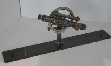
Instrument - Surveyor's Instrument, Boxed Theodolite, c late 1880s
According to Max Clarke this item was used by the surveying classes at the Ballarat School of MinesA boxed (timber) theodolite with crossbars and full-length stadia wires. The theodolite can be mounted on a metal straightedge base. The box also contains a magnetic compass with two bubble levels, a plumbing folk, and 4 brass paper clips designed to suit a plan table. On box in black paint "A 1". Inside box lid is manufacturer's label and Stadia measurement zero reference calibration.ballarat school of mines, surveying equipment, gurley, max clarke, theodolite, stadia measurement, calibration, scientific instrument -
Federation University Historical Collection
Map, Creswick Gold Field Map, 1981
A fragment of the original 1880 map is also held in the collection. See 116Rectangular geological map with brown paper strip on top edge with 4 holes on top edge. Scale is 40 chains to one inch.Geologically and topographically surveyed by Ferdinand M Krause. Lithographed by R. Shepherd. Printed by J. Finnie. Mining Department, Melbourne. Preprinted with additional shaft and lead detail. F. D. Atkinson, Government Printer 1981creswick, krause, surveyor, smeaton, spring hill, tourello, ascot, dean, bullarook, gold fields, gold -
 Federation University Historical Collection
Booklet, City of Ballarat Mayor's Report, 1957-1958, 1958
Ballarat was created a municipality on 17 December 1855, declared a Borough on October 1863, Proclaimed a City on 09 September 1970.Green covered bookcity of ballarat, mayor's report, annual report, jack chisholm, city of ballarat coat of arms, arms of ballarat, john a. chisholm, arthur nicholson, alan pittard, gordon scott, arthur mason, frederick oliver, oscar curnow, frank woodward, william roff, francis cutts, nathaniel callow, kenneth webb, mrs john a. chisholm, queen mother, raaf school of radio, city engineer's department, public health report, finance, mr k. h. mitchell, mr f. j. rogers, building surveyor's department, mr j. b. menhennet, mr r. g. campbell, city health inspector, mr. r. g. biggs, weights and measures inspector, mr. w. mccormack, libraries, mr r. a. mccallum, streets, parks and gardens, water supply and sewerage, ballaarat's voluntary community committees, service clubs, city traffic, mr. j. h. sorrell, sturt street gardens, ballarat base hospital, st john of god hospital, queen elizabeth centre, black hill, black hill reclaimation, ballarat benenevolent asylum -
Federation University Historical Collection
Booklet, Instruments and Adjustments, 1865
Black covered exercise books with hand written by William Baragwanath. The handwritten notes are a copy of manuscript notes by A. Lilley Esquire and lent to Wiliam Baragwanath by J. Walker Esquire Ballarat and copied out in Septemeber 1895. Headings include: Instruments Chromatic Aberration Spherical Aberration Chromatic Spherical Aberration Notes by Professor Kernot on the Adjustment of the theodolite Sydney notes on Adjustment of Transit Theodolite Collimatino in Altitude Levelling To adjust a box sextant The Chain (Steel tape Projections of the Sphere W. Baragwanath Walhalla 1895mining, ore dressing, william baragwanath, alfred mica smith, instruments, theodolite, chain, surveyors chain, kernot, a. lilley -
 Federation University Historical Collection
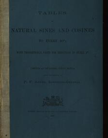
Booklet, Tables of Natural Sines and Cosines to Every 10", 1885, 1885
Blue soft covered book. cosine, 10", p f adams, surveyor-general, sydney government -
Federation University Historical Collection
Report, James Stirling, Assistant Geological Surveyor, Report on Rapid Surveys of the Gold-Fields, 1898, 1898
Foolscap report by Ferdinand Krause, issued by James Travis, Acting Secretary for Mines. department of mines, james stirling, a.w. howitt, warrandyte, nillumbik, greensborough, queenstown, a.o.e. whitelaw -
Federation University Historical Collection
Report, James Stirling, Assistant Geological Surveyor, Report on Rapid Surveys of the Gold-Fields, 1895, 1895
Foolscap report by Ernest Lidget, issued by James Travis, Acting Secretary for Mines. department of mines, j. travis, ernest lidgey, mannidar -
 Federation University Historical Collection
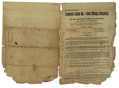
Document, Lawaluk Estate No. 1 Gold Mining Company Prospectus, 1934, 26/06/1934
Prospectus for the Lawaluk Estate No. 1 Gold Mining Company Prospectus, 1934 squire, r.b. squire, lawalul estate no. 1 gold mining company, mining, shares, william collard smith, g.b. hogg, j.b. regan, s. maddison, r.t> moore, kames clements, h.a. o'connor, w.e. watts, d. fitzpatrick, lawaluk estate, mt lawaluk, robert allan, surveyor, leigh river -
 Federation University Historical Collection
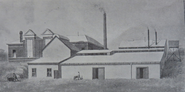
Booklet - Booklet - Prospectus, Bairnsdale District School of Mines, Prospectus, 1904, 1904
Higher education in east Gippsland dates back to 1890, and the opening of the Bairnsdale District School of Mines, In 1986 the Bairnsdale School of Mines and the Sale and Bairnsdale Technical schools amalgamated to form the East Gippsland Community College of TAFE. In 1995 it became the East Gippsland Institute of Technology, and in 2011 changed its name to Advance TAFE. The Bairnsdale District School of Mines Prospectus includes the members of council, a photographic image of the school, teaching staff, rules relating to students and instructors, Constitution, and a prospectus of subjects including Mining and Science Subjects, Diploma Courses, Preliminary Training, Metallurgy Course, Mining Engineering Course, Battery Manager's Certificate, Assayer's Certificate. It also includes a scale of fees, information on the Metallurgical Plant, Chemistry, Assaying and Metallurgy, Geology, Mining Geology, Mining, Petrology, Dynamics and Heat, Magnetism & Electricity, Mechanics Applied to Mining, Land Surveying, Mine Surveying, Algebra, Euclid, Trigonometry, Mechanical Drawing, Practical Plane Geometry, Practical Solid Geometry, Engineering Drawing, Art Subjects, and a list of certificates issued by the school since 1892.Grey soft covered book of 68 pages. The Bairsndale District School of Mines Prospectus includes the members of council, an photographic image of the school, teaching staff, rules relating to students and instructors, Constitution, and a prospectus of subjects including Mining and Science Subjects, Diploma Courses, Preliminary Training, Metallurgy Course, Mining Engineering Course, Battery Manager's Certificate, Assayer's Certificate. It also includes a scale of fees, information on the Metallurgical Plant and its chares, Chemistry, Assaying and Metallurgy, Geology, Mining Geology, Mining, Petrology, Dynamics and Heat, Magnetism & Electricity, Mechanics Applied to Mining, Land Surveying, Mine Surveying, Algebra, Euclid, Trigonometry, Mechanical Drawing, Practical Plane Geometry, Practical Solid Geometry, Engineering Drawing, Art Subjects, and a list of certificates issued by the school since 1892.bairnsdale district school of mines, bairnsdale, school of mines, donald clark, francis w. sewell, j.v.r. anderson, a.d. pleydell, walter seehusen, director, mining engineering, metallurgy, academy of arts, municipal surveyor, 1914