Showing 9224 items matching "baily"
-
 Port Melbourne Historical & Preservation Society
Photograph - Port Melbourne Festival Parade, Bay Street, David Thompson, 28 Feb 1993
One of four colour photos taken during the Port Melbourne Festival 28 February 1993: Festival parade in Bay Street, passing Pier Hotel - theatre groupcelebrations fetes and exhibitions, port melbourne festival -
Port Melbourne Historical & Preservation Society
Map - Chart, Port Phillip, 1930
Photocopy in two large sections, of soundings chart for Port Phillip Bay, surveyed by Commander Henry L Cox RN, 1864, with corrections and additions to 1921. Lower section.(Original had stamp of John Donne & Son Stationers)transport - shipping, port phillip bay -
 Otway Districts Historical Society
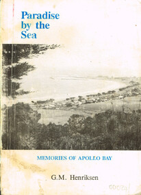
Book, Paradise by the sea. G.M. Henriksen, 1989
Paradise by the sea: memories of Apollo Bay. G.M. Henriksen. 1st ed. Drumcondra (Vic.); Pearce Printing & Publishing; 1989. x, 252 p.; illus. Soft cover.Autographed by the author on the title page.paradise by the sea; g.m. henriksen; apollo bay; memories; -
 Buninyong & District Historical Society
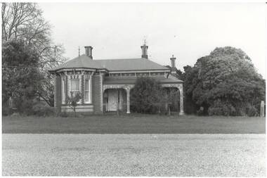
Photograph - B/W photograph, Mr C J Brooks, Former Presbyterian Manse, Buninyong, 19 July 1994
Built for Rev. Thomas Hastie, C19thFormer Presbyterian Manse, Scott St Buninyong, built for Rev. Thomas Hastie. Brick construction, bay window, polychrome, 3 chimneys, ornate wrought iron verandah.buninyong, presbyterian, manse, brick building -
 University of Melbourne, Burnley Campus Archives
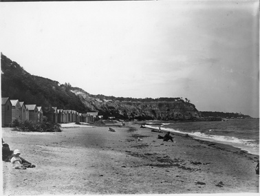
Photograph - Black and white print, Port Phillip Bay Beach, Unknown
Black and white photograph. Port Phillip Bay beach, excursion. Stretch of beach with bathing boxes, several people sitting on the beach, cliff face at far end of beach.port phillip bay beach, excursion, bathing boxes -
Port Melbourne Historical & Preservation Society
Booklet, Pat Grainger, Railway Rockeries -Tales of the Melbourne & Hobsons Bay Railway Reserves, Port Melbourne, 2003
Launched in August 2003 at the Hotel Albion overlooking the Reserves, this project was assisted by the City of Port Phillip Cultural Programs Board through its cultural Development fund, and by the City of Port Phillip Community Grants Scheme'Railway Rockeries -Tales of the Melbourne & Hobsons Bay Railway Reserves, Port Melbourne', a 16 page booklet produced as the first of an A5 series on Port Melbourne's public placestransport - railways, melbourne & hobsons bay railway company -
Port Melbourne Historical & Preservation Society
Plan, Bay Street Site Analysis, C. 1990
A site analysis plan for the development of Bay Street, Port Melbourne. The Street plan shows suggestions for tree planting, verandah changes, proposed open space & building use.bay street, built environment - commercial -
 City of Moorabbin Historical Society (Operating the Box Cottage Museum)
Photograph - Map of Dendy's Special Survey, 1852 Map of Henry Dendy's Special Survey of 1841, 19th Century
A Map drawn in 1852 that shows the 5,120 acres that formed Dendy's Special Survey of 1841. In 1840 Henry Dendy, a farmer in Surrey, England acquired a "Special Survey" from the Commissioners for Land and Emigration which gave Dendy the right to choose land in Port Phillip for the "bargain basement" price of only £1 per acre for 5120 acres, (an area of 8 square miles). The Special Survey also included the right to "the shipment of a worker for every £20 spent on land, whose free passage was paid by the Crown, equalling a total of 100 workers ". Accordingly Dendy sold his English holdings and paid the required £5120 and arrived in Melbourne in February 1841. However by this time land in the new colony was selling for £5 - £40 per acre. Because Henry Dendy possessed the order from the Colonial Office in London he was able to successfully oppose Governor LaTrobe's attempts to alter the price of the land. Dendy appointed Jonathan Were, (an entrepreneur, who had arrived in 1839), as his Manager and who later became a partner. Together, Dendy and Were decided on an area 5 miles south from Melbourne, bounded by North Road, East Boundary Road, South Road and to the west by Port Phillip Bay. Were and Dendy pitched their tents in the area now known as ' Park St, Brighton' and sank a well near the corner of 'St Andrew's St and Wells St'. By 1845 J.B Were and Company had bought almost half of Dendy's land and Were built himself "Moorabbin House" in Were St Brighton made from stone, quarried from local cliffs. It was still standing in 1924. Legend records Moorabbin is named after the Aboriginal word for ' Mother's Milk ' The soil is very fertile and well supplied with water especially in the area called 'East Brighton' - now known as Bentleigh and East Bentleigh - By 1850 the area had developed with numerous market gardens, dairy farms, fruit gardens and vineyards supplying food for the growing population of Melbourne.This Map shows the birth of the Brighton and Moorabbin area. On 18th January1859 Brighton was proclaimed a Municipality and a Borough by October 1863. Meanwhile, following a Petition, the area of East and South Brighton, incorporating Mordialloc, Cheltenham, Mentone, Sandringham and Oakleigh separated from Brighton to form the Moorabbin District Roads Board becoming the first Local Government Authority. Col. William Mair was elected as the first Chairman of the Moorabbin Roads Board. Moorabbin Shire 1871 developed further and was declared a City in1934. The City of Moorabbin was the largest Municipality in Melbourne before the Amalgamation of Councils in 1994 when it was divided in the south to City of Kingston and in the north to City of Glen Eira A Photo-lithographed 1852 Map showing the 5,120 acres that formed Dendy's Special Survey of 1841. Henry Dendy & Jonathan Were chose an area 5 miles south from Melbourne, bounded by North Road, East Boundary Road, South Road and to the west by Port Phillip Bay. Moorabbin County of Bourke / Photo-Lithographed at the department of Lands and Survey. /Melbourne. / Price 1/- brighton, moorabbin, bentleigh, cheltenham, dendy henry, bent thomas, were jonathan, special survey -
 Bendigo Military Museum
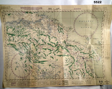
Map - AERONAUTICAL MAP of LAE AREA, RAAF et al, Aug 1944
Refer to Cat 5547 for Matheson.This map is on heavy paper. it is coloured and on one side only. Scale 1:1,000,000. The top centre is the Ramu Valley. Right side is Finchafen, bottom town is south of Salamaw.It shows in pencil where ...were dropped at Nadzab. the enemy track heading NW up to Dumpu. Then movements around Astrolab Bayww2, new guinea, map -
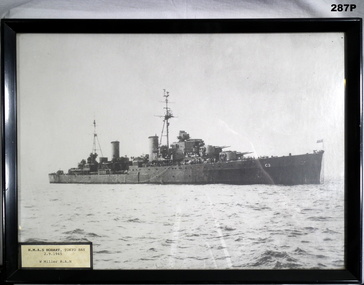 Bendigo Military Museum
Photograph - FRAMED PHOTOGRAPH HMAS HOBART, 2.9.1945
Copy of B&W photo of HMAS Hobart in black painted wooden frame.Handwritten in black ink on back of frame "HMAS HOBART TOKYO BAY / 2nd Sept 45 / SIGNING ARMISTICE / Bill Miller"photography - photographs, navy ran, hmas hobart -
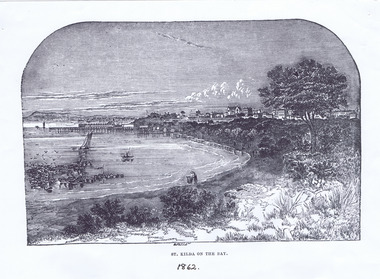 St Kilda Historical Society
Photograph - Lithograph, St Kilda on the Bay, 1862
St Kilda Beach and piers, Christ Church on the hillblack and white lithograph, unmounted, copy, fair conditionSt Kilda on the Bay. 1862 Copy courtesy LaTrobe Library, Melbourne, from: The illustrated Melbourne Post, January 1862, p12. -
 Ringwood and District Historical Society
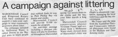
Newspaper, Scrapbook Clipping, Library Collection, Ringwood, Victoria
Newspaper clipping from "The Mail", 2-7-96, P 7Maroondah Council and Ringwood Rotary Club have combined to support a state-wide campaign to raise community awareness about litter. The campaign, initiated by Melbourne Water is called Drains to the Bay and aims to teach people that rubbish finds its way to Port Phillip Bay via drains and creeks. -
Port Melbourne Historical & Preservation Society
Container - Bottle, J W Mowatt, Chemist, Port Melbourne, c. 1890
Mowat's were at 57 Bay Street and later 163 Bay Street, from c1890 and at least into the 1960s. Much of their equipment, containers etc are at Sovereign Hill.Chemist's bottle, inscribed J.W. Mowatt, Port MelbourneJ.W. Mowatt, Port Melbournebusiness and traders - chemists, john w mowat, j w mowat - chemist, bay street -
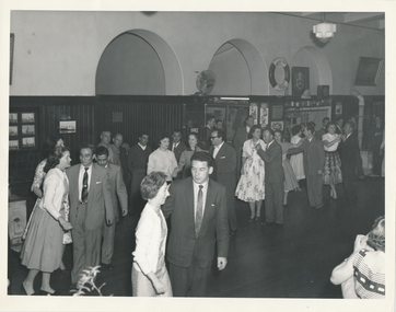 Mission to Seafarers Victoria
Photograph, Melbourne Harbour Trust, Dance in the Flying Angel Club, 1959
The life buoy from the Largs Bay located above the bar helps dating the photograph to post 1957: Largs Bay was launched in 1921, as a mixed passenger/cargo ship. During WW2 she took part in a large number of convoys.nIt was scrapped in 1957 so had a service life of 36 years. Her sister ships were Jervis Bay, Moreton Bay, Esperance Bay and Hobsons Bay. She carried many passengers to Australia to start new lives after WW2. In the bar we can notice advertising helping dating: Peters ice cream Choc Wedge (launched in 1949) at 6d, Cottee's flavoured drinks (Passiona, Lime Coola, Orange, Lemon) In the 1950s, the ladies from the LHLG were still active and dancing with seamen was part of their activities.BW photograph depicting couples dancing in the Flying Angel Club of the Flinders Street Mission.lhlg, dance, seamen, flinders street, cottees, lime coola, passiona, orange, lemon, choc wedge, life buoy, largs bay, ice cream, peters -
 Bendigo Military Museum
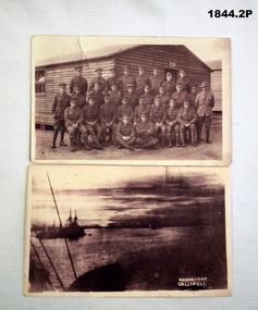
Postcard - PHOTOGRAPHS WW1, C.WW1
“Roy” is Roy Leslie Thurlow No 2493 AIF, KIA. Refer 1890P for his service history. Bovington Camp is in England..1) Photo shows a group of 28 Soldiers outside of hut No C18 The original card was written on. .2) Image shows ships in the bay. In white in the corner are the words "Moonlight Gallipoli" .1) “To Claude from Roy, we had this taken at Bovington Camp”photography - photographs, post cards -
Phillip Island and District Historical Society Inc.
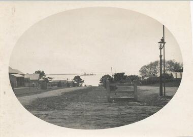
Photograph, 3/10/1920
This postcard is contained in an album presented to the then Governor of Victoria, The Earl of Stradbroke, by the fathers of soldiers & returned soldiers of Phillip Island, on 16/02/1923. The history of the album is noted on Reg. No 85-00Postcard of view of Thompson Avenue looking north to HMAS Australia in Western Port Bay, 3-10-1920; a gas lamp, the first cypress trees and the first motor garage.local history, photography, photographs, slides, film, hmas australia, thompson avenue, shipping, sepia photograph, cypress trees first planting -
 Phillip Island and District Historical Society Inc.
Photograph, Thompson Avenue, Cowes Phillip Island, 1920
This is from Jessie Smith's collection presented by Stan McFee. The vessel is HMS Australia. Avenue shows young Cypress trees planted in 1912 approx.Black & White Photograph of Thompson Avenue, looking north across Western Port Bay. Silhouetted ship in middle. Young Cypress in middle with lamp-post and pole at extreme right.HMS Australia 1920 Coweslocal history, photographs, mains street - streetscape - cowes, phillip island, black & white photograph, jessie smith, main street cowes 1920, stan mcfee -
 Phillip Island and District Historical Society Inc.
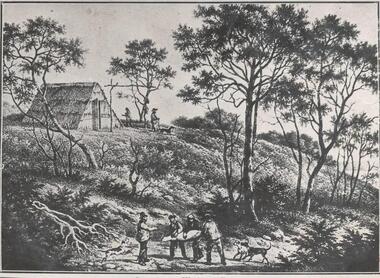
Photograph, Bryant West
One of a collection of over 400 photographs in an album commenced in 1960 and presented to the Phillip Island & Westernport Historical Society by the Shire of Phillip IslandPhotograph of a Pen Drawing of First Dwelling of White People on Phillip Island. Thatched or Bark Hut. Group of Sealers in foreground. Possibly situated at Sealers Cove (now Cat Bay)local history, photography, historic, dwelling, huts, sealers, building - historic, john jenner, bryant west -
 Glenelg Shire Council Cultural Collection
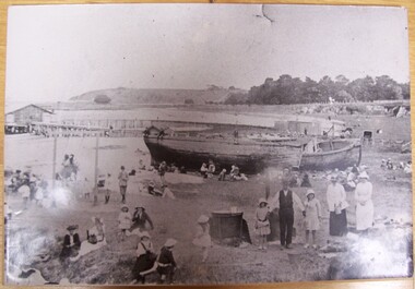
Photograph - Photograph - beach scene, Portland, n.d
Displayed at History House.Black and white photograph of Portland Bay mounted on thick cardboard. Eyelet in top of mount. Families on beach. Lighters (wrecked) on beach. Copper in foreground. Children on swing. Pier in background.Back: Donated to History House 24/1/1992 by Vern McCallum.portland, beach scene, photography -
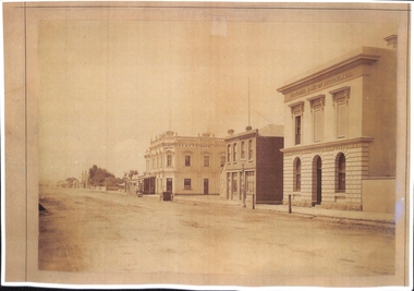 Port Melbourne Historical & Preservation Society
Photograph - Bay Street, Charles Nettleton, Charles Nettleton, 1878-79
This photograph can be dated to 1878-79 because according to Chartered Scoundrel's by Pat Grainger, Scott's Hotel only operated during those years. The National Bank of Australasia at the right of the photograph was designed by Leonard TERRY of Terry and Oakden, Architects and was constructed in 1874. It was subsequently extended to a design by architect George JOBBINS in 1889. See Cat No 197 for a photograph of the altered building.Mounted Charles NETTLETON original: looking northeast in Bay Street: National Bank of Australiasia, grocery shop, Scotts Hotel, trees at Holy Trinity, George Hotel, unmade roadnational bank of australasia, charles nettleton, built environment - commercial, scott's hotel, bay street -
Port Melbourne Historical & Preservation Society
Plan - Proposed bridge under Hobsons Bay railway at Clarendon Street, Emerald Hill, 1854 - 1884
Plan of proposed bridge under Hobson's Bay Railway at Clarendon Street, Emerald Hill, affecting Sandridge railway and Sandridge Road. Flood level re Sandridge line is shown.transport - railways, flood, emerald hill, town planning -
Port Melbourne Historical & Preservation Society
Document - Citation, Faram Bros store, City of Port Phillip Heritage Review, Adam Lovell & Associates, 2007
Copy of Citation No 242 (2 pages), City of Port Phillip Heritage Review. The premises is Faram Bros shop at 405-415 Bay Street and the document outlines the significance of the building.built environment - commercial, built environment - domestic, business and traders - hardware, faram brothers hardware, bay street, city of port phillip heritage review, a g warren, m b muir -
Port Melbourne Historical & Preservation Society
Photograph - View of pier and Bay and foreshore, visit of HMS Hood and HMS Renown, Princes Pier, Port Melbourne, 1924
Photos originally held by Walter Scott, Company Secretary at SwallowsB& W photograph of the visit of HMS Hood, Renown, Repulse, Delhi and Danae in 1924 at Princes Pier .02 - view to pier and bay with more of Port Melbourne foreshore buildingspiers and wharves - princes pier, celebrations fetes and exhibitions, armed services - foreign services, armed services - navy, hms repulse, hms renown, hms hood, hms delhi, hms danae -
Port Melbourne Historical & Preservation Society
Photograph - Various locations in Port Melbourne and around the docks, 1800s - 1900s
Scans of 38 photographs from the album of Henry Whatty, the grandfather of the donor. Includes family photos; Swallow & Ariells cart; Bay shipping; warships; yachts in harbour; "Mildura" at dockbuilt environment, built environment - industrial, sport - yachting, transport - shipping, business and traders - bakers, henry whatty, ilona mccarthy -
Port Melbourne Historical & Preservation Society
Photograph - Aerial view of Port Melbourne, 1993
Two large colour aerial view photographs of Port Melbourne piers and surrounds: .01 - View from land .02 - View from the bay Abel Tasman is at Station Pierpiers and wharves - station pier, piers and wharves - princes pier, piers and wharves - webb dock, built environment - domestic, transport - shipping, abel tasman, port melbourne primary school, missions to seamen -
Port Melbourne Historical & Preservation Society
Photograph - Chequers Inn Hotel, Bay Street, Port Melbourne, Arthur Rowan, 1985
As a member of the Port Melbourne Historical and Preservation Society, donor Arthur ROWAN photographed a series of significant buildings in the Port and South Melbourne area over several years. A selection of nineteen of these was presented to the Port Melbourne Society in 1993.Small print mounted on white card, with mounted, typed caption: Chequers Inn Hotel 316 Bay St First established 1859 Original Licensee Edward J Crockfordbuilt environment - commercial, business and traders - hotels, arthur rowan, edward john crockford, chequers inn -
Port Melbourne Historical & Preservation Society
Photograph - Bruno, Joe, Teresa and Tony Cannatelli sitting on the bonnet of a Ford Falcon, Bay Street, Port Melbourne, 1969
B&W photo of Bruno, Joe, Teresa and Tony Cannatelli sitting on the bonnet of a Ford Falcon, north side of Bay Street, outside Faram's, near Raglan Street, 1967built environment - commercial, transport - motor vehicles, antonio cannatelli, joe cannatelli, bruno cannatelli, teresa cannatelli -
Port Melbourne Historical & Preservation Society
Audio - Oral History, Kevin STANES, MMTB Bus Driver, 31 May 2016
Kevin STANES, a former MMTB bus driver, discusses his experiences based from the bus depot in Bay St. Interviewed by Pat GRAINGER. Duration 0:47:45transport - bus, melbourne and metropolitan tramways board, mmtb, kevin stanes -
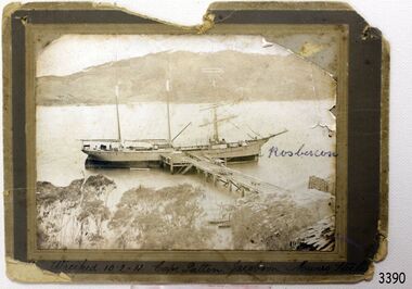 Flagstaff Hill Maritime Museum and Village
Photograph, before 1911
Photograph, black and white, of the three-masted barque SPECULANT at a jetty in low water. On the jetty and the shore are stacks of cut timber. The ship is in a wide river or bay, hills in the background, trees (like gum trees) in the foreground. Inscribed "Wrecked 10.2.11. Cape Patten. Jacobson. Munro. - - - -" Written on the photograph in blue pen "Rosbercon". (The SPECULANT was wrecked on 10th February 2011 at Cape Patton, Victoria, (not Patten as on the photograph). She was sailing under the control of Captain James Jacobsen and her First Mate was James Mumro.) The barquentine SPECULANT was a steel, three-masted sailing ship built in 1895 in Inverkeithing, Scotland, registered in Warrnambool, Victoria and wrecked at Cape Paton, Victoria, 10th February 1911. The SPECULANT had been involved in the timber trade between the United Kingdom and Russia, until sold to its Warrnambool owners and timber merchants Messrs. P.J. McGennan & Co. (Peter John McGennan) in 1902 for 3000 pounds and had her sailed to Warrnambool as her new port. Peter John McGennan was born in 1844 and worked as a builder and cooper in Holyhead, Anglesea, Wales. He immigrated to Australia in 1869 as a free settler and arrived in Warrnambool in 1871 and undertook management of a property in Grassmere for Mr. Palmer. Peter met his wife Emily in South Melbourne and they married in 1873. They had ten children including Harry who lived to 1965, and Andrew who lived until 1958. (The other children were their four brothers - John who was killed in the Dardenalles aged 35, Frederick who died aged 8, Peter who died aged 28, Frank who died aged 5 weeks - and four sisters - Beatrice who died age 89, Edith who died aged 49, Blanche who died aged 89 and Eveline who died aged 48.) In 1874 Peter starting a boating establishment on the Hopkins River. In 1875 he opened up a Coopers business in Kepler Street next to what was Bateman, Smith and Co., moving to Liebig Street, next to the Victoria Hotel, in 1877. In 1882 he then moved to Lava Street (which in later years was the site of Chandlers Hardware Store). He was associated with the establishment of the Butter Factory at Allansford. He started making Butter Boxes to his own design and cheese batts for the Butter Factory. In 1896 established a Box Factory in Davis Street Merrivale, employing 24 people at its peak, (it was burnt down in 1923); and in Pertobe Road from 1912 (now the Army Barracks building). Peter was a Borough Councillor for Albert Ward from 1885 to 1891, he commenced the Foreshore Trust (including the camping grounds along Pertobe Road), and he was an inaugural Director of the Woollen Mill in Harris Street, buying an extensive share-holding in 1908 from the share trader Edward Vidler. They lobbied the Town Hall to have a formal ‘Cutting’ for the waters of the Merri River to be redirected from its natural opening south of Dennington, to its existing opening near Viaduct Road, in order to have the scourings from the wool at the Woollen Mill discharged into the sea. He sold Butter Boxes around the state, and had to ship them to Melbourne by rail. Peter’s purchase of the SPECULANT in 1902 enabled him to back-load white pine from Kaipara, New Zealand to Warrnambool to make his butter boxes then, to gain profitability, buy and ship potatoes and other primary produce bound to Melbourne. (McGennan & Co. had also owned the LA BELLA, which had traded in timber as well, until she was tragically wrecked with the loss of seven lives, after missing the entrance channel to Warrnambool harbour in 1905. It appears that the SPECULANT was bought to replace the LA BELLA.) In 1911 the SPECULANT had been attempting to depart Warrnambool for almost the entire month of January to undergo docking and overhaul in Melbourne. A month of east and south-easterly winds had forced her to remain sheltered in Lady Bay, Warrnambool apart from one morning of northerlies, when an attempt was made to round Cape Otway; she had to return to shelter in Portland after failing to make any headway. With only 140 tons of sand ballast aboard, the ship would not have been easy to handle. Captain Jacobsen and his crew of nine, mainly Swedes, decided to make for Melbourne, leaving Portland Harbour on 5th February 1911. By the 9th they had reached Cape Otway, where they encountered a moonless night, constant heavy rain, and a heavy sea with a south-easterly wind blowing. After safely rounding Cape Otway the course was changed to east, then north-east to take the vessel to a point six miles off Cape Patton, following the orders of Captain Jacobsen, who told the crew to be very careful with the steering, as the wind and sea was running to leeward. The patent log (used to measure speed) had been out of order for the last four months as no-one in Warrnambool was able to fix it: it was intended to have it repaired in Melbourne. In the meantime the crew measured the vessel's speed by looking over the side and estimating wind strength. This compounded the difficulties of imprecise positioning, as the strong cross wind and sea were acting on the lightly laden vessel to steadily drive it towards the shore. At 3.30am on Friday 10 February 1911 Captain Jacobsen and the first mate were looking over the side of the vessel when they heard the sound of breakers and suddenly struck the rocks. The crew immediately knew they had no chance of getting the SPECULANT off, and attempted to rescue themselves by launching the lifeboat, which was instantly smashed to pieces. One of the crew then volunteered to take a line ashore, and the rest of the crew were all able to drag themselves to shore, some suffering hand lacerations from the rocks. Once ashore they began to walk along the coast towards Lorne, believing it was the nearest settlement. Realising their mistake as dawn broke they returned westwards to Cape Patton, and found a farm belonging to Mr C. Ramsden, who took them in and gave them a change of clothes and food. After resting for a day and returning to the wreck to salvage some of their personal possessions, at 10am on Saturday they set out for Apollo Bay, a voyage that took six hours, sometimes wading through flooded creeks up to their necks. The Age described the wreck as "listed to starboard. All the cabin is gutted and the ballast gone. There is a big rock right through the bottom of her, and there is not the slightest hope of getting her off". A Board of Marine inquiry found that Captain Jacobson was guilty of careless navigation by not taking steps to accurately verify the position of the vessel with respect to Cape Otway when the light was visible and by not setting a safe and proper course with respect to the wind and sea. It suspended his certificate for 6 months and ordered him to pay costs. The location of the wreck site was marked for a long time by two anchors on the shoreline, until in 1970 the larger of the two anchors was recovered by the Underwater Explorers' Club and mounted on the foreshore at Apollo Bay. The bell from the wreck was also donated to the Apollo Bay Surf Lifesaving Club but is recorded to have been stolen. Rusting remains of the wreck can still be found on the shoreline on the southern side of, and directly below Cape Patton. Parts of the SPECULANT site have been buried by rubble from construction and maintenance works to the Great Ocean Road, as well as by naturally occurring landslides. Peter J McGennan passed away in 1920. The Gates in the western wall of the Anglican Church in Henna Street/Koroit St are dedicated to him for his time of community work, which is matched with other prominent Warrnambool citizens; Fletcher Jones, John Younger, J.D.E (Tag) Walter, and Edward Vidler. After Peter J McGennan's death Harry, Andrew and Edith continued to operate the family business until July 11th 1923 when the company was wound up. (Andrew lived in Ryot Street Warrnambool, near Lava Street.) Harry McGennan (Peter and Emily’s son) owned the Criterion Hotel in Kepler Street Warrnambool (now demolished). His son Sid and wife Dot lived in 28 Howard Street (corner of Nelson Street) and Sid managed the Criterion until it was decided by the family to sell, and for he remained Manager for the new owners until he retired. Harry commenced the Foreshore Trust in Warrnambool around 1950. The McGennan Carpark in Pertobe Road is named after Harry and there are Memorial-Stone Gates in his memory. (The Gates were once the original entrance to the carpark but are now the exit.). Peter’s great-grandson, also called Andrew, is a Security Officer in Warrnambool. The Patent Log (also called a Taffrail log) from the SPECULANT, mentioned above, and a number of photographs, are now part of the Collection at Flagstaff Hill Maritime Village. The SPECULANT is historically significant as the largest ship to have been registered in Warrnambool, and is believed to have been the largest barquentine to visit Melbourne. It is evidence of the final days of large commercial sailing vessels involved in the Victorian and New Zealand timber trade. The SPECULANT is listed on the Victorian Heritage Register VHR S626Photograph, black and white, of the three-masted barque SPECULANT at a jetty in low water. On the jetty and the shore are stacks of cut timber. The ship is in a wide river or bay, hills in the background, trees (like gum trees) in the foreground. Inscribed below photograph "Wrecked 10.2.11. Cape Patten. Jacobson. Munro. - - - -" Written on the photograph in blue pen "Rosbercon"Inscribed below photograph "Wrecked 10.2.11. Cape Patten. Jacobson. Munro. - - - -" Written on the photograph in blue pen "Rosbercon"flagstaff hill, warrnambool, shipwrecked-coast, flagstaff-hill, flagstaff-hill-maritime-museum, maritime-museum, shipwreck-coast, flagstaff-hill-maritime-village, warrnambool historical photograph, cape patten, munro, james munro, la bella, speculant, cumming and ellis, international timber trade, p. j. mcgennan and co. warrnambool, peter mcgennan, capt. james jacobsen, warrnambool maritime history