Showing 26591 items
matching buchan-river-view-hotel
-
 Ringwood and District Historical Society
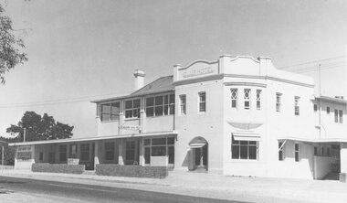
Photograph, Club Hotel, Mount Dandenong Road, Ringwood East - 1960
Written on back of photographs, "Club Hotel Ringwood East. 1960." "Club Hotel, Mt. Dande Rd. 1960" and "1960 Club Hotel" -
 Ballarat Heritage Services
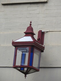
Photograph - Colour, Craig's Royal Hotel Lamp Over Stables Entrance, 2017, 15/09/2017
Hotel Lamp outside Craig's Royal Hotel, Ballarat.craig's royal hotel, lamp, lighting, hotels, hotel lamp -
 Federation University Historical Collection
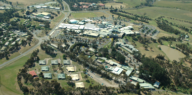
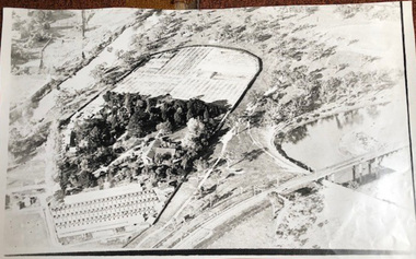
Photograph, Aerial View of Gippsland Campus South View
Colour photograph of an aerial view of Gippsland Campus (South View)churchill campus, gippsland campus, binishell, student residences -
 Victorian Interpretive Projects Inc.
Photograph - Colour, Clare Gervasoni, View from Nevin's Road towards the Swiss Italian Enclave at Yandoit Creek, 2014, 12/2013
For a 2004 comparative view see http://victoriancollections.net.au/items/52fdd83d2162ef1820380448 Two colour photographs showing the view from Nevin's Road towards the Swiss Italian Enclave at Yandoit Creek, 2014yandoit, yandoit creek, yandoit hill, gervasoni, drystone, swiis/italian -
 University of Melbourne, Burnley Campus Archives
Photograph - Black and white print, Aerial View of Burnley Campus c. 1930, c. 1934
Black and white photographs. Aerial Views of Burnley Campus. Enlargements. (A) Heyington Bridge to South, Yarra River on North side. (B) Heyington Bridge at top of photograph i.e. reverse view of (A). (C) Original of (B) mounted on board. Probably taken at the time of the floods of 30 November 1934. heyington bridge, yarra river, aerial view, burnley campus, 1934 flood -
 Lorne Historical Society
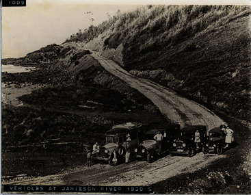
Photograph, Vehicles at Jameson River 1930
Vehicles at Jameson River 1930g.o.r: jameson river 1930: -
 Lakes Entrance Historical Society
Print, River scene
acrylic painting on river sceneillustration, reproductions -
 Ballarat Heritage Services
Photograph, Lisa Gervasoni, Avoca River, Victoria, 2011, 06/08/2011
Colour photographs of the Avoca Riveravoca, avoca river, pre olympic swimming pool -
Federation University Art Collection
Oil, Wise, K, 'River Scene' by K. Wise
This item is part of the Federation University Art Collection. The Art Collection features over 1000 works and was listed as a 'Ballarat Treasure' in 2007.Framed landscape showing a river.art, artwork, k. wise, landscape -
 Kew Historical Society Inc
Photograph, J F C Farquhar, A View in Studley Park Road, 1891
At the beginning of the 1890s, the Kew businessman and Town Councillor, Henry Kellett, commissioned J.F.C. Farquhar to photograph scenes of Kew. These scenes included panoramas as well as pastoral scenes. The resulting set of twelve photographs was assembled in an album, Kew Where We Live, from which customers could select images for purchase.The preamble to the album describes that the photographs used the ‘argentic bromide’ process, now more commonly known as the gelatine silver process. This form of dry plate photography allowed for the negatives to be kept for weeks before processing, hence its value in landscape photography. The resulting images were considered to be finely grained and everlasting. Evidence of the success of Henry Kellett’s venture can be seen today, in that some of the photographs are held in national collections.It is believed that the Kew Historical Society’s copy of the Kellett album is unique and that the photographs in the book were the first copies taken from the original plates. It is the first and most important series of images produced about Kew. The individual images have proved essential in identifying buildings and places of heritage value in the district.This is the earliest known photograph of the exterior of Byram (later Tara Hall). It shows the original red brick fence, its asymmetrical gate and gateposts, with a large terra cotta gargoyle surmounting the higher of the two. The architect, Edward Kilburn designed Byram in the Arts & Crafts style for the industrialist George Ramsden. Construction began in 1888 and was reputed to have lasted three years. The mansion had frontages to Studley Park Road and Stevenson Street, including gardens laid out with great taste, including pleasure grounds, tennis lawn, fruit and flower garden, and paddock. The size of many of the trees in the garden indicate that many survived from the garden of Clifton Villa, the previous single-storeyed house built on the site by the Stevenson brothers. Byram had views to Melbourne and Port Phillip Bay. The house was demolished in 1960, despite opposition from the National Trust (Victoria), and its gardens subdivided into residential allotments.A View in Studley Park Roadkew illustrated, kew where we live, photographic books, henry kellett, byram, tara hall, goathlands -
 Eltham District Historical Society Inc
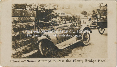
Photograph - Business Card, C. Aarons, Moral - "Never Attempt to Pass the Plenty Bridge Hotel.", c.1920
Circa 1920 Business Card: Plenty Bridge Hotel, Lower Plenty via Heidelberg C. Aarons, Licensee Humorous business card warning motorists of the dire consequences attempting to negotiate the Plenty River Bridge should they decide to pass by the hotel with stopping.marg ball collection, c. aarons, car crash, golf club hotel, lower plenty bridge hotel, plenty bridge hotel, lower plenty bridge -
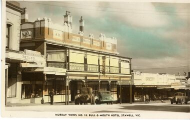 Stawell Historical Society Inc
Postcard, Bull & Mouth Hotel in Main Street Stawell with Dane Bros on the right c1950 -- Postcard -- Coloured
Bull & Mouth Hotel Main Street Stawell Built 1907. Dane Bros on right Murray Views No. 16. c1950stawell streetscape -
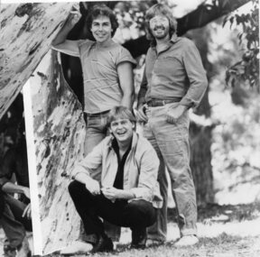 Vision Australia
Photograph - Image, Little River Band
Musicians Beeb Birtles, Graeham Goble and John Farnham appear in this composite image, which has another band member (Wayne Nelson) removed, created for the 1982 Carols by Candlelight program. B/W photograph of Beeb Birtles, Graeham Goble and John Farnham attached to a white piece of paper.40% Members of the Little River Band.carols by candlelight, beeb birtles, graeham goble, john farnham -
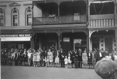 Stawell Historical Society Inc
Photograph, Crowd lining up in the Main Street near Town Hall Hotel c1940's
Photo of crowd lining up in front of Main Street Stawell buildings near Town Hall Hotel. Prichard's Milk Bar. Taylor Draper. Town Hall Hotel. c1940's. The two story building in the center was once owned by W. Whiteside, Taylors and the Prichard's milk bar once owned by Bone, Saddler & Harness Factory. Sepia photograph of Crowd lining Main Street Stawell in the 1940's. The crowd is outside a two story building with an ornate balcony and between Prichard's Milk Bar and the Town Hall Hotel. Two people are leaning on the upstairs balcony. The crowd are all looking to the right and consist of a mixture of young and older people. Prichard's Milk Bar on one building. Taylor and Draper on another.stawell business, streetscape -
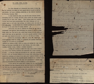 Federation University Historical Collection
Document, Leigh River Mine Papers
In 1905 Richard Squire was manager of the West Berry Consols at Allendale, and developed an improved system of mine ventilation, which was supported in "The Age."[4] He was successful in combating and remedying the gas and ventilation troubles of the Deep Mines of Creswick and Allendale Districts after all had failedSeveral papers from Leigh River Mine including Proprieetary Mining Syndicate, Prospectus and Report on the Leigh River plateaurichard squire, leigh river mine, prospectus, syndicate, preliiminary syndicate, report -
Port Melbourne Historical & Preservation Society
Book, Kristin Otto, "Yarra - A Diverting History of Melbourne's Murky River", 2005
"Yarra - A Diverting History of Melbourne's Murky River" by Kristin Otto. History of Yarra River covering commercial and social uses."To Port Melbourne Historical and Preservation Society, with best riverside wishes. Kristin Otto"yarra river, kirstin otto -
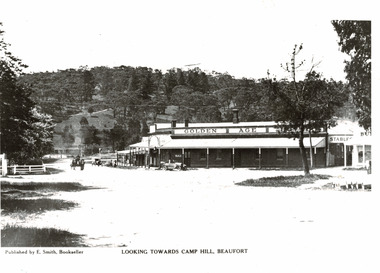 Beaufort Historical Society
Photograph - Beaufort streetscape, View to Camp Hill
View from Livingstone Street Beaufort towards Camp Hill. Shows Golden Age Hotel.Black & White PhotographPublished by E Smith Booksellerbeaufort, historic beaufort streetscape, golden age hotel, beaufort hotels -
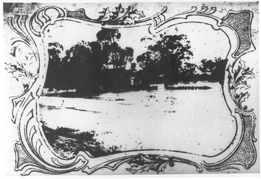 Tarnagulla History Archive
Photographs: Loddon River, Newbridge after flood, Loddon River, Newbridge after flood, 1909 (original image)
On 20th August,1909 the Laanecoorie Weir broke away and released 18.3 million cubic metres of water through the opening and causing severe damage to all towns downstream. At Newbridge, Petersen's bakery collapsed and Simpson's Store and Hotel flooded to the roof. The billiard table was later found in a tree five miles down the Loddon near Learmonth. Murray Comrie Collection. Two copies of a monochrome photograph, image depicts the area near Loddon River at Newbridge after major flood in 1909. This is a very grainy and dark copy of an older original. Copy probably made by Murray Comrie in the 1960s.newbridge, loddon river, flood, bridge -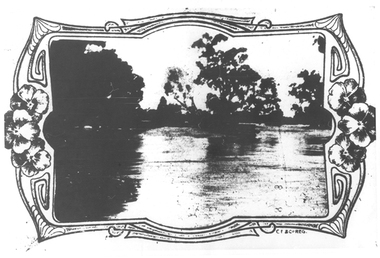
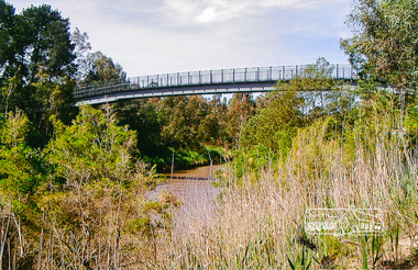 Eltham District Historical Society Inc
Photograph, Footbridge across the Yarra River at Eltham Lower Park
The Yarra River Footbridge was opened in August 2004 and links the Diamond Creek Trail between the Shire of Nillumbik and City of Manningham. It is a shared pathway and also links with the Main Yarra Trail. It affords lovely views over the Yarra River.Colour photographbridge, eltham lower park, eltham south, homestead road, lenister farm, yarra river, footbridge, lookout, diamond creek trail -
Ringwood and District Historical Society
Envelope, Packet: Ringwood Area Hotels - Coach and Horses, Empress India, Burnt Bridge. Also Antimony Mine Hotel Proclaimed 1878
Hotels list; Coach and Horses Hotel; Club Hotel Sept-1887 Wiggin sold to Lindsey; Empress India Hotel; Antimony Mine Hotel, East Ringwood, Cnr Main & Pratt St proclaimed 21-Jan-1878 owing to increase in mining population, 4 licences in locality; Burnt Bridge Hotel; "Duke of York" -
 Whitehorse Historical Society Inc.
Photograph, Hill Hotel
Black and white photograph of the front of Hill Hotel, Mitcham. The hotel was delicensed in 1919|See also NP1329. Alternative name - O'Callaghan's Hotelhill hotel, o'callaghan's hotel, hotels -
 Whitehorse Historical Society Inc.
Leisure object - Beer Glass
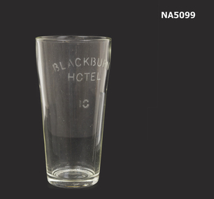
Glass used at Blackburn Hotel, Whitehorse Road Blackburn Vic.10 ounce clear beer glass with "Blackburn Hotel" and "10" etched on glassBlackburn Hotel 10blackburn hotel -
 Orbost & District Historical Society
black and white photographs, Snowy River Mail, August 21 1987
These photographs are from the Snowy River Mail newspaper, September 9, 1987. Ron Hayward's family ran a shop in Rupert Street, Orbost.This item is associated with the history of the Orbost-Bairnsdale railway line and therefore reflects the role that the rail line played in the social and economic history of Orbost. The closure of the line was a significant event in Orbost's history.Five black / white photographs related to closure of the Orbost - Bairnsdale Railway Line.3104.1 - on back - "A view from Grandview, Newmerella, of the last train to leave Orbost on Friday August 21, 1987. As the afternoon sun lengthens the shadows on the Snowy River flats, the sun also sets on an era in Far East Gippsland transport as the last train crosses the viaduct." 3104,2 - 0n back - "Ron Hayward passes over the staff during the last crew changeover for the last train to run on the Orbost line. Ron Haywood (L) who 39 years and 6 months ago drove the first diesel loco to Orbost (T366T) presents the last staff to the driver, Bill Buckley, who took the last diesel out." 3104.3 - on back -" as above - 2nd paragraph only 3104.4 - on back - " Ron Hayward who took the first diesel engine from Bairnsdale to Orbost on February 21. 1957 when he was stationed at Orbosst. Last Friday he rode on the last diesel to Orbost after obtaining a special pass from V Line , he also handed over the staff for the last change at Orbost. The last driver was Bill Buckley." 3104.5 - on back - "LAST TRAIN ROLLS INTO ORBOST B/A Friday August 28 1987 For Ron Hayward the last train journey on the Orbost rail line was a sad occasion. Mr Hayward took the first diesel engine from Bairnsdale to Orbost on February 21, 1957, whe he was stationed at Orbost. Last Friday he rode on the last diesel too Orbost after obtaining a special pass from V-Line. He also handed over the staff for the last change at Orbost. The last driver was Bill Buckley. Mr Hayward was an engine driver with nhe railways and transferred to Orbost when steam engines used the line. He left the railways in in 1957 but took up a job with them again in 1968. He said also it was a privilege to have been able to ride on the last train, the occasion was a sad one,"east-gippsland-railway railway-closure hayward-ron buckley-bill orbost-bairnsdale-railway -
 Kew Historical Society Inc
Photograph, J F C Farquhar, Bird's Eye View Looking West, 1891
At the beginning of the 1890s, the Kew businessman and Town Councillor, Henry Kellett, commissioned J.F.C. Farquhar to photograph scenes of Kew. These scenes included panoramas as well as pastoral scenes. The resulting set of twelve photographs was assembled in an album, Kew Where We Live, from which customers could select images for purchase.The preamble to the album describes that the photographs used the ‘argentic bromide’ process, now more commonly known as the gelatine silver process. This form of dry plate photography allowed for the negatives to be kept for weeks before processing, hence its value in landscape photography. The resulting images were considered to be finely grained and everlasting. Evidence of the success of Henry Kellett’s venture can be seen today, in that some of the photographs are held in national collections.It is believed that the Kew Historical Society’s copy of the Kellett album is unique and that the photographs in the book were the first copies taken from the original plates. It is the first and most important series of images produced about Kew. The individual images have proved essential in identifying buildings and places of heritage value in the district.Before true aerial photography became possible, photographers such as J.F.C. Farquhar were compelled to shoot their images from the highest vantage point. Here, it is presumed to be the roof of Xavier College, from which the panoramic view extends west towards the rise of Studley Park. The houses in the foreground face the southern end of Gellibrand Street. Wellington Street is at an angle to the camera with the Queen Street intersection on the near right. The wooden building behind the large horse paddock on the other side of Gellibrand Street is the Kew Recreation Hall, built 1888, demolished 1960. It was reputed to have one of the finest dancing floors in or around Melbourne. The Bowling Green at the rear of the Hall belonged to the Kew Bowling Club. Further west is the Kew Railway Station on Denmark Street, opened to the public in 1887. At this period, much of Studley Park was locked up in large landholdings, dominated by large mansions such as ‘Byram’. Bird's Eye View Looking Westkew illustrated, kew where we live, photographic books, henry kellett, denmark street, kew recreation hall, kew bowling club, wellington street -
 Charlton Golden Grains Museum Inc
Photograph, Cricket Club Hotel, High St Charlton c.1987, c.1987
Cricket Club Hotel c. 1987. Established 1875, rebuilt as two storey building in 1935. Photo part of the Shire of Charlton streetscape series 1987Colour photograph looking east down High St. Two storey, red brick Cricket Club Hotel on RH side of photo. Red car and white ute parked on the other side of the street. Red and white school crossing posts in garden bed on RH side.cricket club hotel, high st charlton, charlton, business, industry -
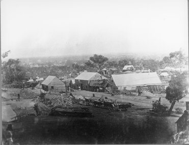 Stawell Historical Society Inc
Photograph, First known photograph of The Reefs and Reef Hotel Pleasant Creek with a bullock team in front 1858 -1861
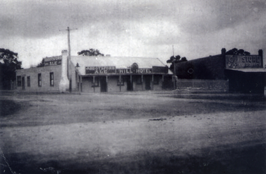
B/W Photo The Reefs Hotel and Assembly Hall Pleasant Creek with Bullock team in front. 1858 -1861 Three windlasses over mineshafts can be seen, two on the left and one in front of the assembly hall. Some horse driven Whims can be seen in the background above the Assembly Hall. This hotel was built right among the mines in upper Main Street. The first licence was held by William Pond in 1858. Robert Young in 1859 and John Steele in 1861. It had a short life as only rates were paid in 1862.Earliest known photograph of the Reefs Pleasant Creek.Several buildings in mining area with trees in background, one building labelled The Reefs Hotel. Spoil heaps in foreground with other mining activities and with bullock team and cart. Man can be seen standing on slab hut roof at centre and woman in street. stawell, hotel -
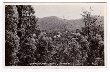 Marysville & District Historical Society
Postcard (item) - Black and white postcard, Valentine Publishing Co. Pty. Ltd, View From Jock's Lookout, Marysville. V. 21, 1923-1963
An early black and white photograph of the view from Jock's Lookout of Marysville in Victoria. An early black and white photograph of the view from Jock's Lookout of Marysville in Victoria. Jock's Lookout is situated on the Marysville-Wood's Point Road. The Marysville-Woods Point Road was originally part of the Yarra Track, constructed in the early 1860s to provide access between Healesville and the Woods Point Goldfields. Despite the steep terrain and engineering difficulties, the Yarra Track soon became a busy route used by pack horses, horse-drawn drays, and wagons. Today this sealed mountain road is a popular scenic drive between Marysville and Warburton. This postcard was published by the Valentine Publishing Co. Pty. Ltd. as a souvenir of Marysville.VALENTINE'S/ POST CARD/ A GENUINE PHOTOGRAPHjock's lookout, marysville, victoria, postcard, valentine publishing co, souvenir, marysville-wood's point road, yarra track, mining, warburton -
 Marysville & District Historical Society
Postcard (item) - Black and white postcard, Valentine Publishing Co. Pty. Ltd, View From Jock's Lookout, Marysville. V. 21, 1923-1963
An early black and white photograph of the view from Jock's Lookout of Marysville in Victoria.An early black and white photograph of the view from Jock's Lookout of Marysville in Victoria. Jock's Lookout is situated on the Marysville-Wood's Point Road. The Marysville-Woods Point Road was originally part of the Yarra Track, constructed in the early 1860s to provide access between Healesville and the Woods Point Goldfields. Despite the steep terrain and engineering difficulties, the Yarra Track soon became a busy route used by pack horses, horse-drawn drays, and wagons. Today this sealed mountain road is a popular scenic drive between Marysville and Warburton. This postcard was published by the Valentine Publishing Co. Pty. Ltd. as a souvenir of Marysville.VALENTINE'S/ POST CARD/ A GENUINE PHOTOGRAPHjock's lookout, marysville, victoria, postcard, valentine publishing co, souvenir, marysville-wood's point road, yarra track, mining, warburton -
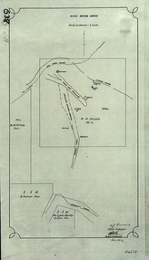 Federation University Historical Collection
Plan, King River Mine, 1932, 12/1932
Copy of a plan of King River Mine.mount lyell, king river, mining, tasmania, king river mine, k.m. white, h. turner, k.j. finnacane, blake