Showing 33220 items matching "buildings/streetscapes"
-
 Frankston RSL Sub Branch
Glass, Souvenir
A wine glass. This glass was made for the 11th anniversary celebrations of the opening of the new Frankston Returned & Services League of Australia club building held in 1987. The glasses feature an image of the new club building and details of the history of the club in gold leaf applied to the external surface of the glass. The glass is made from clear glass and is gold lipped.The glass is inscribed with the following in gold leaf: "FRANKSTON R.S.L. 11th ANNIVERSARY 1987" beneath an image of the new club building and a brief précis of the major events in the club history. -
 National Trust of Australia (Victoria)
Invitation
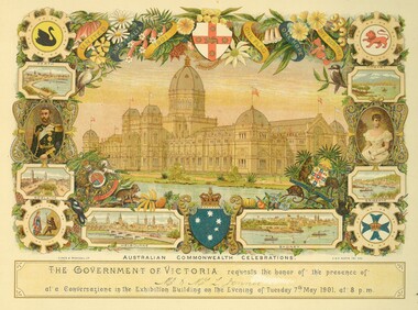
All the invitations are for the celebrations in Melbourne connected with the opening of the Parliament of the Commonwealth of Australia, on the 9th of May 1901. The Duke and Duchess of Cornwall and York were to be present.An invitation to Mr and Mrs Jenner to attend a Conversazione in the Exhibition Buildings, on 7th May 1901 at 8pm. Card depicts a sketch of the Exhibition Buildings. Surrounding the sketch are the coats of arms for the six states, sketches of the Capital cities, Australian flora and fauna and portraits of the Duke and Duchess of Cornwall and York. The coats of arms of the Commonwealth and Australia."AUSTRALIAN COMMONWEALTH CELEBRATIONS" "THE GOVERNMENT OF VICTORIA requests the honor of the presence of Mr & Mrs L Jenner at a Conversazione in the Exhibition Building on the Evening of Tuesday 7th May 1901 at 8 p.m.rippon lea -
 Bendigo Military Museum
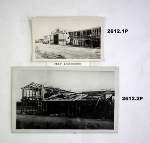
Photograph - PHOTOGRAPHS, DARWIN WW2, 1942
Collection of black & white photographs with typed captions detailing some of the destruction of buildings, shipping & equipment during & after the first attack on Darwin by the Japanese (Feb 19th 1942)..1) Bombed building. .2) Bombed building. .3) Bombed hangar. .4) Bombed store building. .5) Water tower with aircraft in background. .6) Bombed 2 storey building. .7) Sunken ship with 2 ships in background. .8) Scrapped aeroplane. .9) Small steam train..1) On back: More RAAF Drome damage. .2) On back: RAAF Drome. No opposition than couple of Wirraways & Kittyhawks. .3) On back: Hangar RAAF Drome when the Nips finished. .4) On back: First bomb on Post Office Darwin. .5) On back: Jap plane (pos zero) flying around water tower, Darwin loco before arrival of Spitfires at Darwin. .6) On back: Bob Dyers bank Darwin. .7) On back: Neptuna on side alongside wharf & 2 ships on mud at low tide Darwin Harbour. .8) On back: Scrap heap Bathelor field. .9) On back: Fly used on wharf at Darwin before Japs bombed wharf & sunk Neptuna standing there.photography-photographs, military history - war damage, passchendaele barracks trust -
 Port Melbourne Historical & Preservation Society
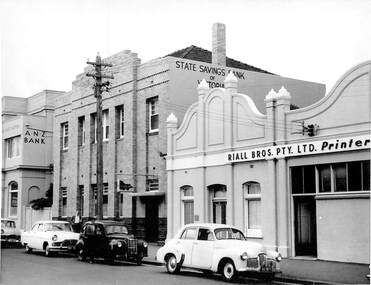
Photograph - SSB building with cars c 1950s, Public Records Office Victoria (PROV), 1886 - 1982
The State Savings Bank building was constructed c1891. Remodeled in 1940sCOPYRIGHT Public records Office Victoria .06 1948 building with cars (incl Holden) parked at front. Also shown are ANZ building to east and Riall Bros on West built environment - commercial, business and traders, transport - motor vehicles, state savings bank of victoria, general motors-holden, gmh -
 Stawell Historical Society Inc
Photograph, Shire Building Pleasant Creek 1866. Photographic Committee National Trust Photographs of Stawell
... Buildings ...7006 National Trust Photographs Shire Building Pleasant Creek 1866Series of Colour Photographs of buildings of interest to National TrustJune 1993buildings, heritage buildings -
 Rutherglen Historical Society
Image, c1870
... buildings ...Building is believed to be the Rutherglen Court House before its 1905 renovations.Black and white photograph of an early brick building in Rutherglenrutherglen, buildings, rutherglen court house -
 Federation University Historical Collection
Book, Ballarat Conservation Guidelines, 1981, 1981
The Guidelines were commissioned by the City of Ballarat , Historical Buildings Preservation Council and the Australian Heritage Commission.Cream soft coloured book of 60 pages. Contents include - Contributary Commercial Buildings, New COmmercial Buildings, Contributary residential Buildings, New Residential Development, Public and In stitutiona Buildings, Railways, Cemeteries, Botanic Gardens, Lake Wendouree, Public Open Spaces, Street Works, Fences and Landscaping, Advertising Guidelines, Lydiard/Camp Street Precinct Case Studyballarat, conservation guidelines, lydiard/camp street precinct case study, railway, botanic gardens, guttes, footpaths, signs, signage, fences, robin nuttall, gerald jenzen, ray tonkin, conservation study, architectural styles, verandahs, shopfronts, cast iron, wndy jacobs, miles lewis, gary vines, heritage planning, heritage guidelines -
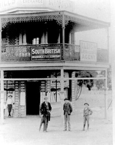 Surrey Hills Historical Society Collection
Photograph, Timothy Leigh's Estate Agency, c 1900, c 1900
Donor information is that the man is Timothy Leigh and the boys are his sons. The building was on the corner of Union Road and Sunbury Crescent. This site was later occupied by New Litho P/L (printers).B&W photo of a 2 storey Victorian building with ornate lacework trim and veranda panels to the upper storey. Signage on the veranda includes "South British Insurance Fire Company" and "T Leigh Land & Estate Agency". The block next door is vacant with some coverage with small trees. A man and 3 boys are standing in front of the building on the roadside.Diagonally across the top LH corner in black ink: "JB & H Leigh" Top centre: "C/O Sunbury Cres and / Union Rd / c1893 / Timothy LEIGH and sons" in blue biro in Alan holt's handwriting, the in the same handwriting on a rectangular white sticker: "SURREY HILLS PROPERTY EXCHANGE BUILDINGS / (N.W. corner of Sunbury Cres and Union Rd SH) / c1893 / Timothy Leight - Estate Agent / with sons Henry and Herbert / (From Mrs Esler HENSHAW of C'bury - Granddaughter / of Timothy and daughter of Henry LEIGH)" Then centre in the same handwriting "3129" Then on a white sticky label in Jocelyn Hall's handwriting: "Given by Mrs Henshaw / to Alan Holt / who gave them to / N. C. Collection" leigh, timothy, real estate agents, insurance agents, t leigh life & estate agency -
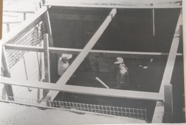 Tatura Irrigation & Wartime Camps Museum
Photograph, Camp 13 Construction Work
Camp 13 building construction, probably goal.Black and white photograph of a building in course of construction probably be the goal.camp 13, building construction in camps -
 Tarnagulla History Archive
Photograph of weatherboard building, Tarnagulla, Weatherboard building, Tarnagulla, Late 1960s
... buildings ...Murray Comrie Collection. Identity of building to be confirmed.Monochrome photograph depicting dark-coloured weatherboard building in Tarnagulla.tarnagulla, buildings -
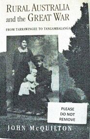 Wodonga & District Historical Society Inc
Book - Rural Australia and the Great War - From Tarrawingee to Tangambalanga, John McQuilton, 2001
This publication covers common issues of life in Australia during World War 1, such as recruitment, fundraising, conscription, homecomings and the construction of memorials. However it is unique in that these aspects of war are examined through a focus on rural communities in North Eastern Victoria. The first chapter describes the region and its towns at the outbreak of war, then discusses the fracturing impact of war on different groups within these communities. It paints an interesting social history at a critical time in Australia's development. John Quilton is a native of North Eastern Victoria, having been born in Yackandandah and educated in Tangambalanga and Wodonga. He was a senior member of the Bicentennial History Project at the University of New South Wales, and head of the History and Politics Program at the University of Wollongong.This book consists of 275 pages including photos and a map, as well as an extensive bibliography. The cover depicts a soldier and his family and a country town streetscape on the back.This publication covers common issues of life in Australia during World War 1, such as recruitment, fundraising, conscription, homecomings and the construction of memorials. However it is unique in that these aspects of war are examined through a focus on rural communities in North Eastern Victoria. The first chapter describes the region and its towns at the outbreak of war, then discusses the fracturing impact of war on different groups within these communities. It paints an interesting social history at a critical time in Australia's development. John Quilton is a native of North Eastern Victoria, having been born in Yackandandah and educated in Tangambalanga and Wodonga. He was a senior member of the Bicentennial History Project at the University of New South Wales, and head of the History and Politics Program at the University of Wollongong.world war 1, rural conditions australia 1914, world war 1 social conditions australia, tangambalanga world war 1 -
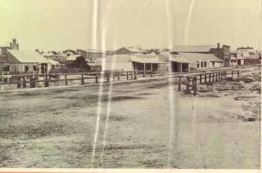 Bendigo Historical Society Inc.
Photograph - LONG GULLY HISTORY GROUP COLLECTION: STREETSCAPE
BHS CollectionBlack and white photo of a streetscape with various buildings, earth street and wood rail fencing. At the right edge is the Commercial Hotel. In the centre is a building with a veranda with P. Pentreath printed above the veranda. At the edge of the veranda is a sign with Post Office on it. Next is a Dr J W Sibley, Physician next to a bakery. On the left of the photo is a slab building with the windows propped open and a cart in the front of it. A two rail fence is in the front of the hut. There are other buildings in the background including what looks like a church behind the slab hut. The photocopy for this item is not available at this time, 23 Jan. 2020. The original photo for this item is at the bottom of box 621bendigo, history, long gully history group, the long gully history group - streetscape, p pentreath, commercial hotel, dr j w sibley? -
 Linton and District Historical Society Inc
Photograph, Traquair House, Linton
This building was the first Bank of New South Wales building in Linton. It was replaced in 1903-04 by a newer building further to the north along Sussex Street. Inscription suggests this photograph was probably taken after 1962 (Stella Surman nee Todd returned to live in Linton at this time, and bought the former bank building, by then called 'Traquair House').Black and white photograph of a brick building, formerly the Bank of NSW, in Sussex Street, Linton"Stella's place at Linton".traquair house linton, stella surman, bank of new south wales linton -
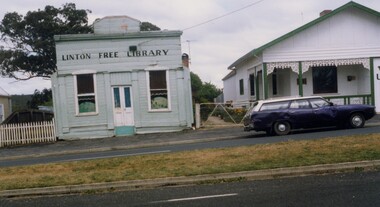 Linton and District Historical Society Inc
Photograph, Linton Free Library, 1988, 1988
... Buildings ...The Linton library opened in 1871 under the auspices of the Linton Mechanics' Institute. It was later funded by grants for Free Libraries, and operated as a lending library until the 1960s. It was known at different times as the Linton Public Library and the Linton Free Library. This photograph shows a somewhat dilapidated "Linton Free Library". The verandah shown in earlier photos of this building has been removed. The building next to it is the former Nelson family home and Nelson Bros. undertaker's office, which was restored in 1987 to become the LDHS Resource Centre.Colour photographs taken in 1988 showing front of a building with a square, pedimented parapet. The building is painted pale blue with white trim, and a chimney can be glimpsed on the right. Next to it a white-painted building with green trim, which has a verandah and pitched roof. Buildings formerly used as library and undertakers.linton free library, nelson brothers undertakers, ldhs resource centre, buildings -
 University of Melbourne, Burnley Campus Archives
Photograph - Black and white prints and negatives, Information Branch Victorian Department of Agriculture, Official Opening of Student Amenities Building, 1973
Incorporated the original canteen built in 1961, using funds raised by the College Ladies Committee under the leadership of Mrs. T.H. Kneen. Building designed by the Investigation and Development Group of the PW.D. with Des Bloink as Supervising Architect, Mackenzies Constructions Pty. Ltd. was the builder. Financed by funds provided through the State Grants (Advanced Education) Act 1969.Note by T.H. Kneen "At rear, partly obscured is C.E. Cole Deputy Director of Agriculture."3 copies black and white photograph. A group of men and a student, Brian Ward, Dux, with Hon. Rupert Hamer standing outside the Student Amenities BuildingOn reverse of 1 copy, " Official Opening of Student Amenities Building L-R Dr David Wishart Director-General Dept Agr, Dux of College, Hon. R.J. Hamer Premier, Victoria, Hon. Ian Smith Minister for Agriculture, C. Pymble Cook Chief of Division of Agric Edn., Eric Littlejohn Principal, BHC." and on all copies, "Photograph by Information Branch Victorian Department of Agriculture Ref. No. E206(4).opening, student amenities building, dr david wishart, director-general, hon. r.j. hamer, premier of victoria, hon. ian smith, minister for agriculture, e.b. littlejohn, principal, burnley horticultural college, ladies committee, des bloink, supervising architect, mackenzies constructions pty. ltd., c.e. cole, deputy director of agriculture, canteen, dux, publicity -
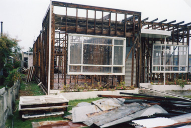 Lakes Entrance Historical Society
Photograph - Glenara development, Holding M, 2002c
Buildings to be demolished to create carpark at rear, Glenara Motel / RSL, Lakes Entrance, VictoriaColour photograph showing a stage in the demolition of Glenara Motel timber framed building, with intact windows, building debris and overgrown garden beds. Lakes Entrance Victoriamotels, rsl clubs -
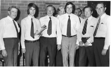
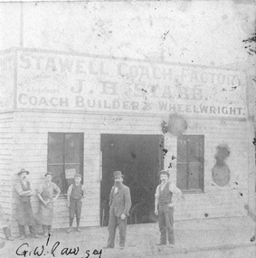 Stawell Historical Society Inc
Photograph, J H Stabb Coach Building Shop with Mr Pawsey G. W. identified
Group of seven males outside Stabb Coach building premises. Pawsey G. W. indicated in front of Stabb Premises. Two photographic copies of a group of 7 males outside "J. H. STABB" Coach Building & Wheelwright, Stawell Coach Building. c 1916G.W. Pawsey written on print.stawell portrait business streetscape -
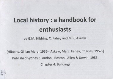 Surrey Hills Historical Society Collection
Book, Extract from: " a handbook for local history"
... buildings ...This extract concentrates on buildings and life styles. It is a lively introduction to the methodology of historical research, written by historians for local history enthusiasts. Ways of tracing the history of buildings is discussed in detail, and likely sources identified.This extract concentrates on buildings and life styles. It is a lively introduction to the methodology of historical research, written by historians for local history enthusiasts. Ways of tracing the history of buildings is discussed in detail, and likely sources identified.buildings, structures and establishments, architectural styles, architecture - domestic -
 Kew Historical Society Inc
Plan, Melbourne & Metropolitan Board of Works : Borough of Kew : Detail Plan No.1571, 1904
The Melbourne and Metropolitan Board of Works (MMBW) plans were produced from the 1890s to the 1950s. They were crucial to the design and development of Melbourne's sewerage and drainage system. The plans, at a scale of 40 feet to 1 inch (1:480), provide a detailed historical record of Melbourne streetscapes and environmental features. Each plan covers one or two street blocks (roughly six streets), showing details of buildings, including garden layouts and ownership boundaries, and features such as laneways, drains, bridges, parks, municipal boundaries and other prominent landmarks as they existed at the time each plan was produced. (Source: State Library of Victoria)This plan forms part of a large group of MMBW plans and maps that was donated to the Society by the Mr Poulter, City Engineer of the City of Kew in 1989. Within this collection, thirty-five hand-coloured plans, backed with linen, are of statewide significance as they include annotations that provide details of construction materials used in buildings in the first decade of the 20th century as well as additional information about land ownership and usage. The copies in the Public Record Office Victoria and the State Library of Victoria are monochrome versions which do not denote building materials so that the maps in this collection are invaluable and unique tools for researchers and heritage consultants. A number of the plans are not held in the collection of the State Library of Victoria so they have the additional attribute of rarity.Original survey plan, issued by the MMBW to a contractor with responsibility for constructing sewers in the area identified on the plan within the Borough of Kew. The plan was at some stage hand-coloured, possibly by the contractor, but more likely by officers working in the Engineering Department of the Borough and later Town, then City of Kew. The hand-coloured sections of buildings on the plan were used to denote masonry or brick constructions (pink), weatherboard constructions (yellow), and public buildings (grey). This plan is the other half of Plan No.1571 representing the constructions to the west of Wellington Street before and in 1903/4. This plan represents the built environment in Edgevale Road, Wellington Street, Atkins Street, Annadale Street, Mortimer Street, and Cotham Road. Whereas there are smaller allotments and more modest housing stock facing Edgevale Road, larger blocks and more substantial houses are represented facing Cotham Road.melbourne and metropolitan board of works, detail plans, mmbw 1571, cartography -
 Kew Historical Society Inc
Plan, Melbourne & Metropolitan Board of Works : Borough of Kew : Detail Plan No.1575, 1905
The Melbourne and Metropolitan Board of Works (MMBW) plans were produced from the 1890s to the 1950s. They were crucial to the design and development of Melbourne's sewerage and drainage system. The plans, at a scale of 40 feet to 1 inch (1:480), provide a detailed historical record of Melbourne streetscapes and environmental features. Each plan covers one or two street blocks (roughly six streets), showing details of buildings, including garden layouts and ownership boundaries, and features such as laneways, drains, bridges, parks, municipal boundaries and other prominent landmarks as they existed at the time each plan was produced. (Source: State Library of Victoria)This plan forms part of a large group of MMBW plans and maps that was donated to the Society by the Mr Poulter, City Engineer of the City of Kew in 1989. Within this collection, thirty-five hand-coloured plans, backed with linen, are of statewide significance as they include annotations that provide details of construction materials used in buildings in the first decade of the 20th century as well as additional information about land ownership and usage. The copies in the Public Record Office Victoria and the State Library of Victoria are monochrome versions which do not denote building materials so that the maps in this collection are invaluable and unique tools for researchers and heritage consultants. A number of the plans are not held in the collection of the State Library of Victoria so they have the additional attribute of rarity.Original survey plan, issued by the MMBW to a contractor with responsibility for constructing sewers in the area identified on the plan within the Borough of Kew. The plan was at some stage hand-coloured, possibly by the contractor, but more likely by officers working in the Engineering Department of the Borough and later Town, then City of Kew. The hand-coloured sections of buildings on the plan were used to denote masonry or brick constructions (pink), weatherboard constructions (yellow), and public buildings (grey). Plan No.1575 shows that in the area bounded by Wellington Street, Edgevale Road, Glenferrie Road, and Cotham Road, there had already been significant subdivision of land and houses constructed. As one of the highest points in Kew, as expected, there were already some significant mansions built on large allotments of land. Many of these mansions are identified by name on the plan such as ‘Kelso’, ‘Abbotsford’, ‘Clarendon’ and ‘Ashlyn’ in Cotham Road. Other houses of equal size are unnamed on the plan.melbourne and metropolitan board of works, detail plans, maps - borough of kew, mmbw 1575, cartography -
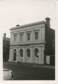 Kilmore Historical Society
Photograph, 39 Sydney Street, 1980's?
Was the building which housed the Old Colonial Bank of Australasia Ltd.9cm x 12.5cm black and white photograph of the building at 39 Sydney Street. The double story building has an ornate light-coloured facade, which darker brickwork on the sides. Arched windows on the ground floor and rectangle window with trim on the top floor. Signage on the building states "Dornal Antiques".storefronts, retail store, antique dealers, antiques -
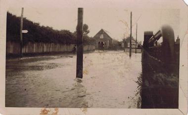 Kew Historical Society Inc
Photograph - Flooded street, 1940-50
View of unknown flooded streetscape.Original, black and white positive of a flooded street, originally believed to have been in Kew, but based on an examination of the history, deemed not to be a location in Kew or Kew East. The flooding is of a T-intersection with a brick church and a house in the background.Inscribed verso: "? Kew / R 774 / VELOX"floods -
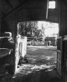 Eltham District Historical Society Inc
Photograph, Montsalvat
Image 2E General view of Montsalvat mud brick buildings including two storied studio The Alistair Knox Collection The Alistair Knox Collection is a series of mounted enlarged photos of mud brick houses and related subjects. The collection is understood to have been put together by Alistair Knox although it is the work of several unacknowledged photographers. For some years it was held by the Building Department of the former Eltham Shire Council and was then passed to our Society for safekeeping. Some of the photos have been used in Knox's books and from time to time some of them have been part of various historical displays. As far as we know there has not been a public display of the whole collection which numbers about forty photographs. The collection has been copied on to slides for the purpose of this meeting and to be retained as part of the Society's pictorial collection. Alistair Knox 1912 - 1986 is acknowledged as the founder of Eltham's mud brick building movement. Many of the buildings shown in the collection are of his design and he was also involved with the construction of several of them. Others are the work of his contemporaries and associates such as Peter Glass, Gordon Ford, and John Harcourt. (EDHS Newsletter No. 145 July 2002)Handwritten notes in pencil re details of building, year of construction, owner, designer, builder, etcmontsalvat, houses, mud brick construction, alistair knox collection -
 Eltham District Historical Society Inc
Photograph, Brocksopp House (1860)
Image No. 1 Brocksopp House erected about 1860 Originally known as Souters Cottage Eltham's first mud brick building Falkiner's Cottage The Alistair Knox Collection The Alistair Knox Collection is a series of mounted enlarged photos of mud brick houses and related subjects. The collection is understood to have been put together by Alistair Knox although it is the work of several unacknowledged photographers. For some years it was held by the Building Department of the former Eltham Shire Council and was then passed to our Society for safekeeping. Some of the photos have been used in Knox's books and from time to time some of them have been part of various historical displays. As far as we know there has not been a public display of the whole collection which numbers about forty photographs. The collection has been copied on to slides for the purpose of this meeting and to be retained as part of the Society's pictorial collection. Alistair Knox 1912 - 1986 is acknowledged as the founder of Eltham's mud brick building movement. Many of the buildings shown in the collection are of his design and he was also involved with the construction of several of them. Others are the work of his contemporaries and associates such as Peter Glass, Gordon Ford, and John Harcourt. (EDHS Newsletter No. 145 July 2002)Handwritten notes in pencil re details of building, year of construction, owner, designer, builder, etcbrocksopp house, falkiner cottage, houses, mud brick construction, souters cottage, alistair knox collection -
 Eltham District Historical Society Inc
Photograph, David and Joan Armfield Studio House and Pottery (1953)
Image 13 David and Joan Armfield Studio House and Pottery Original building commenced by Roger Bell in 1953 Later completed by David and Joan Armfield The Alistair Knox Collection The Alistair Knox Collection is a series of mounted enlarged photos of mud brick houses and related subjects. The collection is understood to have been put together by Alistair Knox although it is the work of several unacknowledged photographers. For some years it was held by the Building Department of the former Eltham Shire Council and was then passed to our Society for safekeeping. Some of the photos have been used in Knox's books and from time to time some of them have been part of various historical displays. As far as we know there has not been a public display of the whole collection which numbers about forty photographs. The collection has been copied on to slides for the purpose of this meeting and to be retained as part of the Society's pictorial collection. Alistair Knox 1912 - 1986 is acknowledged as the founder of Eltham's mud brick building movement. Many of the buildings shown in the collection are of his design and he was also involved with the construction of several of them. Others are the work of his contemporaries and associates such as Peter Glass, Gordon Ford, and John Harcourt. (EDHS Newsletter No. 145 July 2002)Handwritten notes in pencil re details of building, year of construction, owner, designer, builder, etcdavid and joan armfield studio house, david armfield, houses, joan armfield, mud brick construction, roger bell, alistair knox collection -
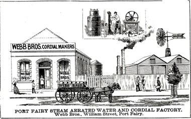 Port Fairy Historical Society Museum and Archives
Drawing - large picture, Webb Bros Cordial Factory
This lithograph shows William Webb's Cordial and Aerated Waters factory on William Street. An 1887 plan shows three buildings forming part of the factory. Black & white etching of Large building of Webb Bros Cordial factory with delivery cart out front and lower wooden buildings to the leftPort Fairy Steam Aerated Water and Cordial Factory Webb Bros. William Street Port Fairyfactory, business, shop -
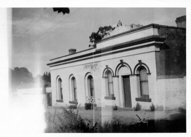
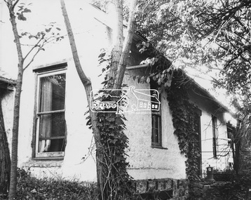
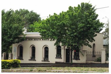 Linton and District Historical Society Inc
Photograph, Traquair House, 90 Sussex Street, Linton, 2014
... Buildings ...Now called 'Traquair House, this building in the early `1860s was the first Bank of New South Wales building, consisting of a banking chamber and residence. It was renovated in the 1870s, and after the bank moved its premises in 1904 it became a family home.Colour photograph of rendered brick building with five arched windows and a door facing onto the street. A chimney can be seen to the left. The words "NEW SOUTH WALES" are visible across the building.buildings, houses, bank of new south wales, traquair house, 90 sussex street linton -
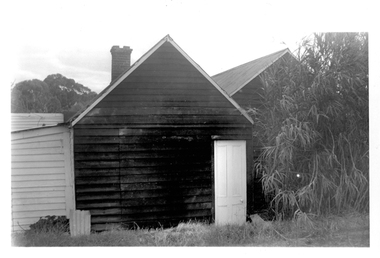
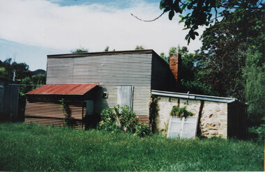 Halls Gap & Grampians Historical Society
Photograph - Coloured, C 2000s
... BUILDINGS ...This is the building that was used as a bakery in the 1940s.A galvanised iron structure with a lower stone outbuilding at the side and a rusting galvanised iron lean-to at the front. The building has a brick chimney and an old, white window is leaning against the front of the stone portion of the building.buildings, bakery -
 Port Melbourne Historical & Preservation Society
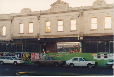
Photograph - Demolition of Market building in Bay St 1989
Market building was established in 1885. Demolition retained the street frontage but new businesses were to come. Colour photo showing demolition of Market Building in By St 1989. Frontage retained. A former passageway through the building enables view of houses in Not St and Council Flatsbuilt environment - civic, built environment - commercial, built environment - demolition -
 Ballarat Heritage Services
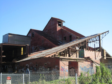
digital photographs, Lisa Gervasoni, Former Standard Brick Works, c2010-2017
The site includes a Hoffman kiln, clay mill building, grinding pans and brick presses, relics of the downdraught kiln stack, office, former locomotive shed, and quarry.The buildings of a brickworks in Box Hill, Victoria.box hill, surrey, surrey drive, brickworks, factory, industrial heritage, ruin, standard brickworks