Showing 1233 items matching "crown land"
-
 St Kilda Historical Society
Photograph - Photo map, 11/01/1968
One of a series of photo-maps produced for the Department of Crown Lands and Survey (1857-1983). For correlation with a current map, and access to other historical photo maps of Victoria, see the Historic Photo-Maps Index published by the Department of Environment, Land, Water and Planning at https://services.land.vic.gov.au/DELWPmaps/historical-photomaps/Black and white aerial photographVic 2132 State Aerial Survey Melbourne 1968 Proj. Run 29E 11.1.68 5100 ASL 196elwood, elwood park, elwood canal, elwood beach, st kilda marina, mc moran reserve, point ormond, 1968 -
 St Kilda Historical Society
Photograph - Photo map, Department of Crown Lands and Survey (1857-1983), 22/01/1970
One of a series of photo-maps produced for the Department of Crown Lands and Survey (1857-1983). For correlation with a current map, and access to other historical photo maps of Victoria, see the Historic Photo-Maps Index published by the Department of Environment, Land, Water and Planning at https://services.land.vic.gov.au/DELWPmaps/historical-photomaps/Black and white aerial photographVic 2358 Department of Crown Lands and Survey Victoria,.© Melbourne 1970 Project Run 41E 22.1.70 5,100 ASL 62caulfield, caulfield north, st kilda east, armadale, 1970 -
 St Kilda Historical Society
Photograph - Photo map, 14/12/1963
One of a series of photo-maps produced for the Department of Crown Lands and Survey (1857-1983). For correlation with a current map, and access to other historical photo maps of Victoria, see the Historic Photo-Maps Index published by the Department of Environment, Land, Water and Planning at https://services.land.vic.gov.au/DELWPmaps/historical-photomaps/Black and white aerial photographVic 1807 Melbourne 1963 Project Run 17 14.12.63 Lens 205 152.70 M/M 5.150 36st kilda, st kilda botanical gardens, balaclava, st kilda east, elwood canal, ripponlea, caulfield north, elwood, caulfield, 1963 -
 St Kilda Historical Society
Photograph - Photo map, Department of Crown Lands and Survey (1857-1983), 22/01/1970
One of a series of photo-maps produced for the Department of Crown Lands and Survey (1857-1983). For correlation with a current map, and access to other historical photo maps of Victoria, see the Historic Photo-Maps Index published by the Department of Environment, Land, Water and Planning at https://services.land.vic.gov.au/DELWPmaps/historical-photomaps/Black and white aerial photographVic 2358 Department of Crown Lands and Survey Victoria,.© Melbourne 1970 Project Run 42E 22.1.70 5,100 ASL 77st kilda, st kilda east, st kilda marina, elwood, elwood canal, elsternwick park, point ormond, balaclava, mc moran reserve, ripponlea, st kilda botanical gardens, peanut farm, 1970 -
 St Kilda Historical Society
Photograph - Photo map, Department of Crown Lands and Survey, 22/01/1970
One of a series of photo-maps produced for the Department of Crown Lands and Survey (1857-1983). For correlation with a current map, and access to other historical photo maps of Victoria, see the Historic Photo-Maps Index published by the Department of Environment, Land, Water and Planning at https://services.land.vic.gov.au/DELWPmaps/historical-photomaps/Black and white aerial photographVic 2358 Department of Crown Lands and Survey Victoria,.© Melbourne 1970 Project Run 43E 22.1.70 5,100 ASL 208elwood, elwood beach, point ormond, elwood park, elwood canal, mc moran reserve, 1970 -
 St Kilda Historical Society
Photograph - Photo map, Department of Crown Lands and Survey, 22/01/1970
One of a series of photo-maps produced for the Department of Crown Lands and Survey (1857-1983). For correlation with a current map, and access to other historical photo maps of Victoria, see the Historic Photo-Maps Index published by the Department of Environment, Land, Water and Planning at https://services.land.vic.gov.au/DELWPmaps/historical-photomaps/Black and white aerial photographCONTROLLED Vic 2358 Department of Crown Lands and Survey Victoria,.© Melbourne 1970 Project Run 41E 22.1.70 5,100 ASL 66st kilda, albert park, st kilda west, catani gardens, st kilda botanical gardens, st kilda pier, st kilda beach, 1970 -
 St Kilda Historical Society
Photograph - Photo map, Department of Crown Lands and Survey, 22/01/1970
One of a series of photo-maps produced for the Department of Crown Lands and Survey (1857-1983). For correlation with a current map, and access to other historical photo maps of Victoria, see the Historic Photo-Maps Index published by the Department of Environment, Land, Water and Planning at https://services.land.vic.gov.au/DELWPmaps/historical-photomaps/Black and white aerial photographVic 2358 Department of Crown Lands and Survey Victoria,.© Melbourne 1970 Project Run 42E 22.1.70 5,100 ASL 75st kilda, st kilda beach, st kilda marina, point ormond, st kilda pier, 1970 -
 St Kilda Historical Society
Photograph - Photo map, 14/12/1963
One of a series of photo-maps produced for the Department of Crown Lands and Survey (1857-1983). For correlation with a current map, and access to other historical photo maps of Victoria, see the Historic Photo-Maps Index published by the Department of Environment, Land, Water and Planning at https://services.land.vic.gov.au/DELWPmaps/historical-photomaps/Black and white aerial photographVic 1807 Melbourne 1963 Project Run 16 14.12.1963 Lens 205 152.70 M/M 5.150 177st kilda, st kilda pier, catani gardens, middle park, albert park, st kilda west, st kilda beach, 1963 -
 St Kilda Historical Society
Photograph - Photo map, Department of Crown Lands and Survey, 22/01/1970
One of a series of photo-maps produced for the Department of Crown Lands and Survey (1857-1983). For correlation with a current map, and access to other historical photo maps of Victoria, see the Historic Photo-Maps Index published by the Department of Environment, Land, Water and Planning at https://services.land.vic.gov.au/DELWPmaps/historical-photomaps/Black and white aerial photographVic 2358 Department of Crown Lands and Survey Victoria,.© Melbourne 1970 Project Run 41E 22.1.70 5,100 ASL 64st kilda, st kilda cemetery, balaclava, st kilda east, windsor, caulfield north, alma park, 1970 -
 St Kilda Historical Society
Photograph - Photo map, Department of Crown Lands and Survey, 08/01/1970
One of a series of photo-maps produced for the Department of Crown Lands and Survey (1857-1983). For correlation with a current map, and access to other historical photo maps of Victoria, see the Historic Photo-Maps Index published by the Department of Environment, Land, Water and Planning at https://services.land.vic.gov.au/DELWPmaps/historical-photomaps/Black and white arial photographVic 2345 Department of Crown Lands and Survey Victoria,.© Melbourne 1970 Project Run 40 8.1.70 5,100 ASL 77albert park, fawkner park, south yarra, middle park, prahran, windsor, st kilda, st kilda west, 1970 -
 St Kilda Historical Society
Photograph - Photo map, 22/01/1970
One of a series of photo-maps produced for the Department of Crown Lands and Survey (1857-1983). For correlation with a current map, and access to other historical photo maps of Victoria, see the Historic Photo-Maps Index published by the Department of Environment, Land, Water and Planning at https://services.land.vic.gov.au/DELWPmaps/historical-photomaps/Black and white aerial photographVic 2358 Department of Crown Lands and Survey Victoria,.© Melbourne 1970 Project Run 43E 22.1.70 5,100 ASL 206elwood, elsternwick, elsternwick park, 1970 -
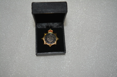 Wangaratta RSL Sub Branch
Badge - Boxed badge, 2012
Badge received by Dorothy Kiely in 2012 on the 70th anniversary of the Australian Women's Land Army. The Australian Women’s Land Army (AWLA) was formed during the Second World War to combat rising labour shortages in the farming sector. From December 1941, when Japan entered the war, the nation’s need to build up its armed forces was placed above the needs of other industries. Agricultural labour was steadily diverted to the armed services and war industry To meet the shortfall in rural labour, State and private women’s land organisations were organised, modelled on those established in Great Britain during the First and Second World Wars. A national body was formed on 27 July 1942 under the jurisdiction of the Director General of Manpower. While policy was devised by the Commonwealth Government, the organisation of the AWLA remained State-based. An extensive recruiting campaign was undertaken for new members. Most members of the existing land armies were later incorporated into the AWLA as well. Black box containing gold star shaped badge with red crown above Australian coat of arms Badge:-Australian Women's Land Army 70th Anniversary 2012 Box:- top in gold lettering 70th Anniversary of the Australian Women's Land Armyawla, ww2, dorothy kiely -
 Victorian Aboriginal Corporation for Languages
Book, Peter Cabena et al, The lands manual : a finding guide to Victorian lands records 1836-1983, 1992
... history crown lands public lands land tenure charts, extracts from ...charts, extracts from original documentsvictorian history, archives, local history, crown lands, public lands, land tenure -
 Victorian Aboriginal Corporation for Languages
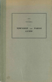
Book, Department of Crown Lands and Survey Victoria, Township and parish guide : Victoria, 1955
A alphabetical list of townships proclaimed under the Land Acts of Victoria. Shows the parish, land district and the municipality in which each is situated, and the particulars of Gazettal of Proclamation.victorian geographical names, victorian administration -
Clunes Museum
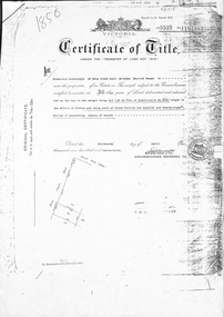
Certificate - CERTIFICATE OF TITLE, 1884
CERTIFICATE OF TITLE. UNDER THE TRANSFER LAND STATUTE CATHERINE GRETTON OF CLUNES PROPRIETOR OF SAID CROWN ALLOTMENT WILLED TO JOHN LUCAS AND WILLIAM GRETTON DATED 28TH JUNE 1899. CATHERINE WOOLCOCK OF CLUNES INHERITED PROPERTY FROM JOHN LUCAS AND WILLIAM GRETTON JUNE 28TH 1899 AT 3 O'CLOCK IN THE AFTERNOON.PHOTOSTAT COPY, VICTORIAN GOVERNMENT CERTIFICATE OF TITLE. CATHERINE GRETTON OF CLUNES. DATED 14TH DAY OF MAY 1884.local history, document, certificates, document - title -
Clunes Museum
Document - EXTRACT, CIRCA 1986
PHOTOCOPY EXTRACT FROM VICTORIAN GOVERNMENT GAZETTE PAGE 3973 NO. 86 - 15 OCTOBER 1986 REGARDING VESTING OF LAND IN THE MUNICIPALITY OF THE SHIRE OF TALBOT AND CLUNES. THAT BEING CROWN ALLOTMENT 34, SECTION C, PARISH AND TOWNSHIP OF CLUNESHANDWRITTEN IN PEN: CLU0066-01756 171/86local history, government, state government, shire of talbot and clunes -
Clunes Museum
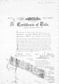
Document - CERTIFICATE OF TITLE, APRIL, 1906
ORIGINAL TITLE FOR THE CLUNES FREE LIBRARY SITE IN TEMPLETON STREET ISSUED TO RALPH COUNDON, GAS MANUFACTURER; ARTHUR HENRY GORDON, MEDICAL PRACTITIONER; AND JOHN FIELD, MINING REGISTRAR - 25TH APRIL, 1906. TITLE TRANSFERRED TO CROWN C.1975 AS NO TRUSTEES LEFTPhotocopy of a Certificate of Title issued in Victoria under the "Transfer of Land Act 1890" Issued on the 26th of April 1906 to the Trustees of the Clunes Free Lending Library from the Crown. Signed by H Hosken Assistant Registrar. Handwritten in black ink; J L Lazarus 1183842 Cluneslocal history, document, certificates, free library -
Stawell Historical Society Inc
Archive - Finance, Land Titles, Incorporation Papers
North Western Woollen Mills Pty. Ltd.PaperCrown Lands Titles Geoge V, George VI, Elizabeth IIfinance -
Koorie Heritage Trust
Book, Butt, Peter et al, Mabo : what the High Court said, 1993
... -- Land tenure. | Torres Strait Islanders -- Legal status laws etc ...This book sets out the High Court Mabo decision in plain English, giving everyone the chance to read the case for themselves. It reduces the judgements to less than a third of their original length. It avoids repetition, translates legalese into English and gathers the judgement into chapters and themes. It looks at the specific issues raised by the High Court judges including terra nullius, Crown sovereignty, land ownership, naive title and protecting native title under the Racial Dicrimination Act.93 p. : ill., 1 port. ; 20 cm.This book sets out the High Court Mabo decision in plain English, giving everyone the chance to read the case for themselves. It reduces the judgements to less than a third of their original length. It avoids repetition, translates legalese into English and gathers the judgement into chapters and themes. It looks at the specific issues raised by the High Court judges including terra nullius, Crown sovereignty, land ownership, naive title and protecting native title under the Racial Dicrimination Act.australia. high court. mabo and others v. state of queensland. | australia. racial discrimination act 1975 | native title - cases - mabo | law - relation to anglo australian law | law - jurisprudence | native title - extinguishment | race relations - racial discrimination - anti discrimination - legislation. | mabo, edward, 1936-1992. mabo and others v. state of queensland. | mabo, edward, 1936-1992 -- trials, litigation, etc. | australia. high court. mabo and others v. state of queensland. | native title (australia) | torres strait islanders -- land tenure. | torres strait islanders -- legal status, laws, etc. | aboriginal australians -- land tenure. | aboriginal australians -- legal status, laws, etc. | land tenure -- law and legislation -- australia. | queensland -- trials, litigation, etc. -
Whitehorse Historical Society Inc.
Document, Jones Family History
... relating to purchase and fencing of land, part of Crown Allotment... and fencing of land, part of Crown Allotment 116G, Lot 2, for building... with papers relating to purchase and fencing of land, part of Crown ...Brief history of the Jones FamilyBrief history of the Jones Family from emigration of James Jones in 1852 to 1970 with papers relating to purchase and fencing of land, part of Crown Allotment 116G, Lot 2, for building of Nunawading South Primary School No 4808, including a native flora area, c 1957. Also papers from the Native Plants Preservation Society of Victoria.Brief history of the Jones Family jones, james, jones family, bette, walter edgar, lionel arthur, kones, k.e. & l.a., native plants preservation society of victoria, nunawading south primary school, no. 4808, mount pleasant road, nunawading, florists, lorikeet street, dagola court, koala avenue -
Whitehorse Historical Society Inc.
Document, Division of Survey and Mapping, 1984
... Mitcham melbourne Crown Lands Victorian Government Land Surveys ...Information guide to Parish and Township Plans - Division of Survey and Mapping - Victorian Government..Information guide to Parish and Township Plans - Division of Survey and Mapping - Victorian Government..Information guide to Parish and Township Plans - Division of Survey and Mapping - Victorian Government..crown lands, victorian government, land surveys -
Whitehorse Historical Society Inc.
Document, Division of Survey and Mapping, 1984
... Mitcham melbourne Crown Lands Victorian Government Land Surveys ...A brief guide to Crown Lands And Survey records commonly used for family history research.A brief guide to Crown Lands And Survey records commonly used for family history research.A brief guide to Crown Lands And Survey records commonly used for family history research.crown lands, victorian government, land surveys -
Whitehorse Historical Society Inc.
Legal record - Land Title, Certificate of Title, 1919
Lots 21 and 22 on Plan of Subdivision no. 6149 Crown Portion 89, Parish of Nunawading vol. 4192 fol. 838287, owned by State Savings Bank of VictoriaLots 21 and 22 on Plan of Subdivision no. 6149 Crown Portion 89, Parish of Nunawading vol. 4192 fol. 838287, owned by State Savings Bank of VictoriaLots 21 and 22 on Plan of Subdivision no. 6149 Crown Portion 89, Parish of Nunawading vol. 4192 fol. 838287, owned by State Savings Bank of Victoriablackburn road blackburn, walsham road blackburn, state savings bank of victoria -
Whitehorse Historical Society Inc.
Legal record - Land Title, Certificate of Title, 23/12/1927 12:00:00 AM
3 Acres 2 roods 8 and 7/10th perches, pt. Crown section 108 Parish of Nunawading, owned by Thomas Gifford Anderson. Vol. 5411 fol. 10820053 Acres 2 roods 8 and 7/10th perches, pt. Crown section 108 Parish of Nunawading, owned by Thomas Gifford Anderson. Vol. 5411 fol. 10820053 Acres 2 roods 8 and 7/10th perches, pt. Crown section 108 Parish of Nunawading, owned by Thomas Gifford Anderson. Vol. 5411 fol. 1082005anderson, thomas gifford, middleborough road burwood east, highbury road burwood east -
 Whitehorse Historical Society Inc.
Document, Deep Creek Road, 13/04/1929
Photocopy of Certificate of Title Vol 5525 Fol. 1104883, land fronting on Deep Creek Road, Mitcham being lot 136 on Plan of Subdivision No 8022, part of Crown Portion 128A, Parish of Nunawading, County of Bourke, in the name of Francisco Schwerkolt, 13 April 1929, on her death in 1946, probate granted to Charles Victor Schwerkolt.Passed to Frances Dora Hogan in 1947, Alice Maud Everitt in 1950, Charles Edward Everitt and Muriel Eileen Priscilla Edwards in 1953, Stanley Ernest Edward Dawson and Iris Rae Dawson in 1973, Glenn Joseph Benham and Judith Rae Benham in 1975 and Ernest Victor Copling and Barbara Ruth Copling in 1980.deep creek road, mitcham, schwerkolt, francesca, charles clarence victor, schwerkolt cottage, hogan, frances dora, everitt, alice maud, charles edward, edwards, muriel eileen priscilla, dawson, stanley ernest edward, iris rae, benham, glenn joseph, judith rae, copling, ernest victor, barbara ruth -
 Whitehorse Historical Society Inc.
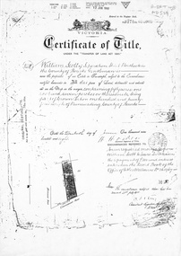
Document, Certificate of Title, 19/07/1918
Photocopy of Certificate of Title Vol. 4156 Folio 831198 for 43 acres Fronting on Canterbury Road near Mitcham Road, being part of Crown Portion 124, Parish of Nunawading, County of Bourke in the name of James Harley Malcolm, 19/7/1918. Last subdivision dated 22/5/1926- current site of Glenburnie Roadland subdivision, malcolm, james harley, mitcham road mitcham, glenburnie road mitcham, canterbury road mitcham, various surnames -
 Whitehorse Historical Society Inc.
Document, Mitcham, 1/03/1915
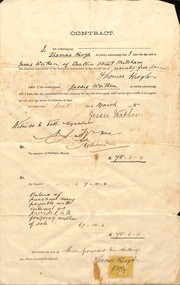
Contract of sale of part Crown Portion 119,05 Mitcham, Parish of Nunawading, County of Bourke being Lot 6 on plan of subdivision No. 5339, by Thomas Keogh to Jessie Wathenland sales, wathen, jessie, keogh, thomas, mitcham -
 Whitehorse Historical Society Inc.
Document, Certificate of Title, 1/06/1908
Photocopy of Certificate of Title Vol 3271 Fol 654003, 50 acres fronting on Canterbury Road, including Scott Street being part of Crown Portion 124, Parish of Nunawading, County of Bourke, in the name of William Scott, 20 June 1908; transfers to 8 October 1936 with notes of previous owners of parts of lot 124 from November 1858.scott street, mitcham, scott, william, polak, nelson, land subdivision, canterbury road, vermont, mitcham road, isaak, johnson, miller frederick, james, becker, lydia malvina, huffey, harry, graham, annie bella, langford, william allan, emily mary, caplin, ethel grace, armstrong, mary, cook, joseph allan, isabella, isaac william, mettzke, frederick oscar, whitmore, doris margaret, elizabeth, thomas, stephen, beach, william griffin, brown, hosking, bonnel, alphonse, saul, martin, richards, twose, richard frederick, charles, george, ham, cornelius job, sprigg, shaw, gavin, william barker, jane, mcclelland, david goodwin, thomas robert -
Whitehorse Historical Society Inc.
Document, Certificate of Title, 1913 - 1933
... Road, Blackburn for land, part of Crown Portion 89 at Blackburn..., Blackburn for land, part of Crown Portion 89 at Blackburn Parish ...Certificate of Title, Mary Elizabeth Allen of Blackburn Road, Blackburn for land, part of Crown Portion 89 at Blackburn Parish of Nunawading County of Bourke.Certificate of Title, Mary Elizabeth Allen of Blackburn Road, Blackburn for land, part of Crown Portion 89 at Blackburn Parish of Nunawading County of Bourke. Vol 3698 Fol 739579 June 19143 also correspondence on rates, 1933.Certificate of Title, Mary Elizabeth Allen of Blackburn Road, Blackburn for land, part of Crown Portion 89 at Blackburn Parish of Nunawading County of Bourke. land titles, shire of nunawading, shire of blackburn and mitcham, allen, mary elizabeth, blackburn road, blackburn -
Whitehorse Historical Society Inc.
Document, Certificate of Title, 1917 - 1933
Certificate of Title, Harrison Rotherham of 'Thulecroft', Albion Street, Surrey Hills, Merchant.Certificate of Title, Harrison Rotherham of 'Thulecroft', Albion Street, Surrey Hills, Merchant. Lots 61 & 62, subdivision 602, Part of Crown Allotment 127, Parish of Nunawading, County of Bourke with a right of carriage way over Harrison and Burnett streets, 1917. Vol 4046, Fol 809049. Also correspondence re rates, enforcement of charge, 1933.Certificate of Title, Harrison Rotherham of 'Thulecroft', Albion Street, Surrey Hills, Merchant.land titles, shire of nunawading, shire of blackburn and mitcham, rotherham, harrison, harrison street, mitcham, burnett street, mitcham