Showing 3431 items
matching distance
-
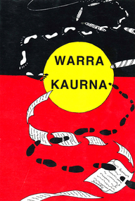 Victorian Aboriginal Corporation for Languages
Book, Rob Amery, Warra Kaurna : a resource for Kaurna language programs, 2008
Notes on spelling and pronunciation / Rob Amery. Kaurna wordlist / Jane Simpson and Rob Amery. Outlines of a grammar, vocabulary, and phraseology of the Aboriginal language of South Australia, spoken by the natives in and for some distance around Adelaide /C.G. Teichelmann, C.W. Schu?rmann.B&w illustrations, colour illustrations, word listskaurna, adelaide -
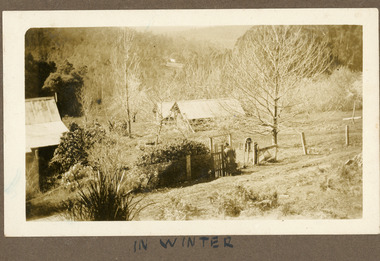 Mt Dandenong & District Historical Society Inc.
Photograph
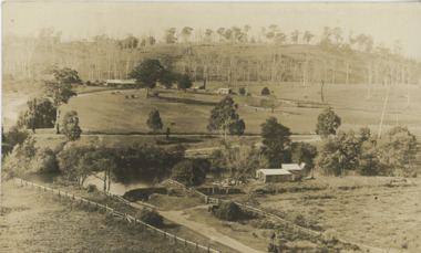
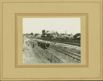
The photograph is from the album of Ivy Child. The buildings form part of the Child family farm where Ivy Child lived with her parents Ted and Ethel Child. The photograph is taken in winter with the trees devoid of leaves. Ivy May Child (1910 – 1989) was the daughter of Arthur Edward (Ted) Child (1878 – 1964) and Ethel May Madden (1888 – 1970). Ted Child was the son of Matthew Francis Child (1839 – 1933) and Martha Jeeves (1857 – 1926). He was the grandson of one of the early pioneers Francis Child. Ivy grew up on the family property on Childs Road and took many photographs. Most of these are glued into her photo album. The album covered the years from c1927 – 1932. Ivy married Henry William Burgess (1906 – 1968) in 1944. The photographs remain in their original state in the album with individual copies made. Sepia photograph showing a group of buildings - a homestead and sheds. There is a wire fence and gate at the front. A woman wearing a hat is about to go through the gate. She is carrying a suitcase. Trees and bushes surround the property and a cleared area and rooftop are visible in the distance.Handwritten below the photograph in album: IN SUMMERivy child, child, winter, ted child, ethel child -
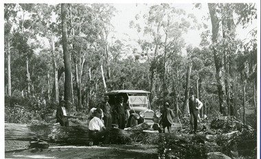 Mt Dandenong & District Historical Society Inc.
Photograph, Car On New Road Blocked By Tree
Site said to be the new Mt. Dandenong Tourist Road a short distance past present Silvandale Store (Kalorama Post Office now). Early model vehicle and passengers delayed by tree across road. Not much progress being made with axe.kalorama, mt. dandenong tourist road, silvandale store -
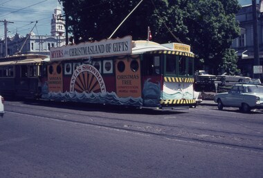 Ballarat Tramway Museum
Slide - 35mm slide/s, 1968
As for 382, but photographed at a shorter distance. Trams 12 and 21 as Myers Christmas tram in City Loop. See 382 for further details. Photo taken during the 1968 Christmas season. See Date advised by Alan Bradley, 15/3/03Niltramways, trams, myers, christmas trams, decorated trams, city loop, tram 12, tram 21 -
 Kew Historical Society Inc
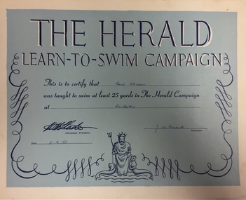
Certificate, The Herald Learn to Swim Campaign, 1963
The Victorian Government's policy was that primary school children should learn to swim.The children of Chatham Primary School were taken by tram to the Kew Baths. The certificate testifies that Gail Norman could swim 25 yards. The Herald Learn to Swim Campaign was founded in 1929. Paper certificate printed in shades of blue and white. The document has the name of the campaign and the promoter at top centre. Other information includes the name of the person to whom the certificate was awarded and the distance swum. The illustration at bottom centre represents Neptune with two mermaids.GAIL NORMAN / KEW BATHS / [UNREADABLE NAME OF EXAMINER] / 8-2-63swimming certificates, gail norman, kew baths, herald learn to swim campaign -
 Kew Historical Society Inc
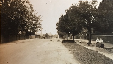
Photograph - Street Works, Studley Park Road, March 1934
Studley Park Road, like most streets in Kew, was originally a dirt road. Street works during the Great Depression included bituminising major roads in the district. This photograph of Council works originated in the City of Kew Engineers Department as a record of works undertaken. It was given to the collection by a Mrs Fisher in 1998.Well provenanced photograph of Council-funded public works in Kew during the Great Depression. Original sepia photographic positive of Studley Park Road, Kew while resurfacing of the street was taking place. The Kew Junction is just visible in the distance. Boys sitting on a drum at right. Behind them is the brick fence and front entrance to Tara Hall.Typed reverse: "B4 / Kew C.C. / Studley Park Road showing drag spread surfacing with premixed material, unrolled material on the right, March 1934"roadworks -- kew (vic.), street works -- kew (vic.), public works kew (vic.), studley park road -- kew (vic.), city of kew -- engineers department, city of kew -- public works -- great depression -- 1930s -
 Wodonga & District Historical Society Inc
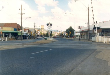
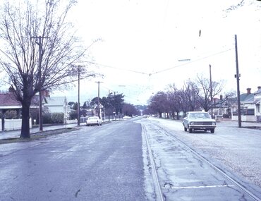
Photograph - Codling Collection 01 - High Street Wodonga looking south from the railway crossing, 1987
Miss Olive Codling was a Foundation Member and a Life Member of the Wodonga Historical Society. Many of her prize-winning photos are held in the Society Collection. She also held a range of roles and committee positions in a wide range of Wodonga community organisations. These included the Horticultural Society, the Wodonga Arts Council, the Wodonga Camera Club and the Wodonga Lapidary Club. This photo collection is significant as it documents how the businesses and buildings in Wodonga have evolved and contributed to community throughout the 20th century.High Street Wodonga looking south from the railway crossing. Railway boom gate and Wodonga Home Furnishers on the right. Safeway sign in the carpark in the background. The Water Tower is in the distance. The Finishing Touch is on the left. This photo was taken for Heritage Week 1987.wodonga businesses, high st wodonga, railway crossing -
 Lakes Entrance Historical Society
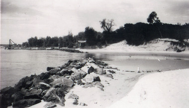
Photograph - Western sand Hummocks, 1946
Black and white photograph showing lake shoreline on western side of entrance piers, with rock retaining wall, walings and crane left middle distance and front of Schnapper cottage, dense vegetation on dune and some erosion to beach. Lakes Entrance Victoria machinery, waterfront, houses -
 Lakes Entrance Historical Society
Photograph - Lakes Entrance, 1935c
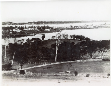
Enlarged from postcard produced for Mrs Allen to advertise Allen's Tearoom at the brow of Myer St hill, known as Allen's Hill to locals.|This is the paired before photograph showing the left hand side on Butchers paddock in the panoramic views, the right hand side number 01715. This photograph used in the 150 year Lakes Entrance 1858-2008 display.Black and white photograph of the township, taken from Allen's Hill, Myer St. It shows the town between Cunninghame Arm and North Arm, cleared and fenced paddocks in foreground, New Works village and sand hummocks in distance. Lakes Entrance Victoria township, waterways, topography -
 Lakes Entrance Historical Society
Photograph - Wombat, 1885c
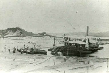
The dredge 'Wombat' owned by John Carpenter, contractor for stage one of cutting the entrance from the lake through to ocean - Bass Strait. Photo shows channel partly dredged and men on work platform in front of dredge.Black and white photograph showing bucket dredge Wombat removing sand from between piers. Dunes on western side on left, lakes in background, hills of Kalimna and Nungurner in distance. Work platform in front of dredge with workers. Lakes Entrance Victoria waterways, public works, dredging -
 Lakes Entrance Historical Society
Postcard - North Arm bridge Lakes Entrance Victoria, Bulmer, H D, 1940c
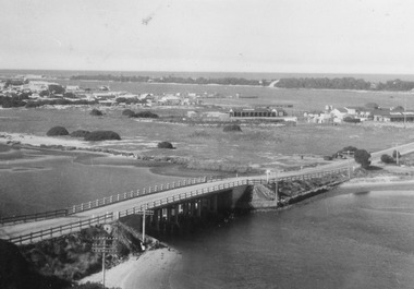
Black and white postcard of bridge across North Arm, showing post and rail fences on abutments; low tide in North Arm; town buildings and Club Hotel, Cunninghame Arm and sand hummocks with ocean in far distance. Lakes Entrance Victoriabridges, township -
 Lakes Entrance Historical Society
Postcard - Tambo Upper
Also another black and white photograph of same scene different angle crop of maize shown, boat on river possibly PS TanjilSepia toned photograph of view across the Tambo River looking eastward from Stephensons Road corner of Riversdale farm on right Redenback House in distance Swan Reach to Bruthen road shown with rinbarked trees on hill Tambo Upper Victoriaagriculture, settlement -
 Wangaratta RSL Sub Branch
Equipment - WW2 Telephone Set, Standard Telephone and Cables Pty Ltd, 1942
An example of a Telephone Set D Mk V which was used by Australian forces during the Second World War for verbal and Morse code communications over short distances via a telephone line.An example of a Telephone Set D Mk V which was used by Australian forces during the Second World War for verbal and Morse code communications over short distances via a telephone line. Rectangular aluminum green painted box with broad canvas webbing strap secured to the side of the body through metal loops. Two vertical webbing loops are attached to the rear of the body. Stencilled in black on top TELE. SET. D. MK. V.'. The housing opens by a hinged fold back lid that is secured by a hook and eye closure. Attached to the inside of the lid are two metal plates. The first is a circuitry diagram, the second is the instructions for use of the set. The interior contains the phone assembly and is divided by a metal shelf. On the left is a bell with two screw terminal in front. At the center is the telegraph key and behind that is the battery box with a small metal plate with, 'TELEPHONE SET. D.MK.V To the right is metal box with two terminals in frontAttached to the bottom of the shelf is a slide out metal key Below the shelf is a compartment in which is stowed a black metal headset with provision for a bakelite handset with attached cord and four-prong plug.Tele Set stamped on outside of unit. Inside lid plaque - Telephone Set D MK V -
 Hume City Civic Collection
Photograph, 1990s
The building which has been damaged by fire is the former Diggers Rest Hotel which was the only surviving hotel along the Calder Highway between the towns of Keilor and Gisborne a distance of approx. 32kms A coloured photograph of a grey rendered building, along a roadside, which has been damaged by fire with a temporary fence surrounding the building. diggers rest, hotels -
 Ballarat Tramway Museum
Slide - 27 mm sq slide/s - set of 2, Lilian Butler, Macarthur St and Drummond St Nth, 1971
1 - Macarthur St with the loop in the mid-distance. 2 - Drummond St north at the intersection with Sturt St, with the Ballarat Base Hospital on the left-hand side. Photos from the collection of Lilian Butler.Yields information about the Gardens via Drummond St North line.One Hanimex colour slides, white cardboard mount, and one AGFA blue and white plastic mount slide. ballarat, tramways, trams, drummond st nth, hospital, macarthur st -
 Flagstaff Hill Maritime Museum and Village
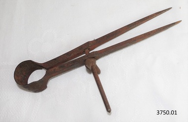
Instrument - Dividers, 1930-1955's
This set of dividers was used for measuring and marking details in the planning making of components for the ship model Sovereign of the Seas. It is part of a collection of objects used by Jim Williams, maker of fine ship models from about 1930-1955. Most of the components for the models, as well as many of the tools, were handmade by Jim Williams. Jim’s family has donated the ship model “Sovereign of the Seas” and many tools, accessories and documents used in the making of this and other ship models have been donated to Flagstaff Hill Maritime Village. Ship model of HMS Sovereign of the Seas, scale model of 17th Century English war ship, was handmade and carved from plans, enclosed in airtight glass case. All components of that model, including even the smallest pulleys, were hand crafted using tools designed and made by Jim. Outstanding details include functional rigging and moving cannons. Please see our record 3732 of the mode Sovereign of the Seas for further details of the ship and the maker.This set of dividers is connected with the hobby and skill of ship model making that has been crafted as a leisure activity for many generations. The hobby is often chosen by serving and retired mariners who appreciate the connection with maritime history. These dividers were used by local Warrnambool man, Jim Williams, who was employed at Cramond and Dickson clothing store, and then at Fletcher Jones menswear for 27 years. It was used in making components for the model of the historic ship, the Sovereign of the Seas. The Sovereign of the Seas was a historic 17th century English war ship with important maritime heritage. Dividers, metal, adjustable with wingnut to hold in place. Used to measure and mark reoccurring distances. This set of dividers is part of a collection of tools and accessories once used by Jim Williams, maker of a series of ship models 1930-1955 including “HMS Sovereign of the Seas”.flagstaff hill, warrnambool, flagstaff hill maritime museum, maritime museum, shipwreck coast, flagstaff hill maritime village, great ocean road, jim williams, james bernard williams, ship model hobby, ship model tools, ship model making equipment, ship model making accessories, technical drawing instrument, dividers for drawing and measuring, set of dividers, sovereign of the sea, ship model, hobby, ship model tool, english war ship, measuring instrument -
 Flagstaff Hill Maritime Museum and Village
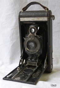
Camera
Camera fold away which expands out along tracks. Adjustment for distance, light aperture and lens speed. Manufactured in Rochester NY USA Model No 2-c, Kodak Jr Film is inserted and removed around 2 rollers at back of cameraflagstaff hill, warrnambool, shipwrecked-coast, flagstaff-hill, flagstaff-hill-maritime-museum, maritime-museum, shipwreck-coast, flagstaff-hill-maritime-village -
 Port Melbourne Historical & Preservation Society
Photograph, James Lauritz, Looking towards the Beacon and Beacon Road housing, 1989 - 1990
Looking towards the Beacon and Beacon Road housing. Shows undeveloped paddocks between Beacon and the railway. Also West Gate Bridge is in the distance James LAURITZ print of Port Melbourne, laminated (one of 18). Copies of slides produced for Port Melbourne Councillocal government - city of port melbourne, built environment, james lauritz, beacon cove, beacons, engineering - bridges, west gate bridge -
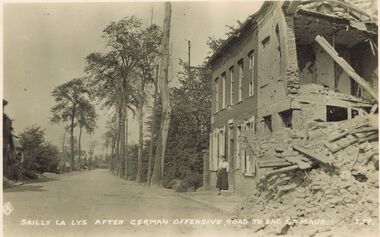 Bendigo Historical Society Inc.
Postcard - ACC LOCK COLLECTION: SAILLY LA LYS AFTER GERMAN OFFENSIVE, ROAD TO BAC ST.MAUR, POSTCARD, 1914-1918
Postcard, WW1, B&W image of Sailly La Lys after a German offensive on the road to Bac St. Maur. Damaged building on the right with a woman standing outside the front door. A lone figure on the road in the far distance. Copy Y 17postcard, ww1, sailly la lys, ruins, france, bac st.maur -
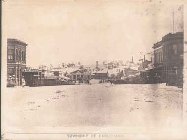 Bendigo Historical Society Inc.
Photograph - WES HARRY COLLECTION: TOWNSHIP OF EAGLEHAWK, C. 1860's
Sepia photograph of the Township of Eaglehawk, looking down the hill from about Victoria St. Visible are the Victoria Hotel and the Exchange Hotel on the left hand side of the photo. At the bottom of the hill there is the old Town Hall and in the distance on the hill is one of the Virginia Reef mines.place, eaglehawk, streetscape, eaglehawk, victoria hotel, exchange hotel, virginia reef -
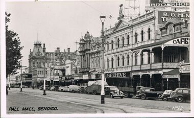 Bendigo Historical Society Inc.
Photograph - BENDIGO - PALL MALL
Photograph - black and white. Photograph of Pall Mall, Bendigo. Written on right hand side No. 22. In the distance you can see shop names like 'Hall and Batchelder', 'Beehive', 'Abbott', 'The Shamrock'. Cafe. many cars parked in the gutter in front of the shops.place, streetscape, pall mall, pall mall bendigo -
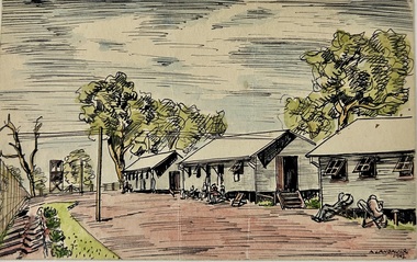 Tatura Irrigation & Wartime Camps Museum
Work on paper - Painting - Watercolour, Camp 2 Tatura
Alfred Landauer was Born in Vienna 13/06/1910. He was a commerical artist who arrived in Australia on board the "Dunera".Pen & Ink and watercolor of three camp huts. Large trees at the rear of the huts. Several internees are reclining in chairs outside each hut. A guard tower is in the distance . A fence runs along the side of the painting and a garden and green grass follow the length of the fence. A. Landauer 1942camp 2, dunera, landauer, watercolor, 1942 -
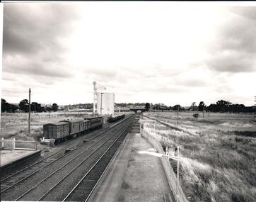 Hume City Civic Collection
Photograph, 1/01/1971
The photograph was taken when railway land on either side of the tracks was used for recreational purposes and agricultural related activities. The local sports ground is on the RHS of the photograph and was used to stage a number of the town's events.A black and white photograph of a section of the two railway platforms and three sets of rail tracks with a stone bridge in the distance. Four rail carriages and eight goods trucks are on a railway siding near a wheat silo. There is open land on either side of the rail tracks.sunbury railway station, wheat silos, railways, macedon street rail bridge., george evans collection -
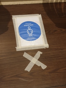 Ballarat Heritage Services
Photograph, Covid19 Panemic Dining Rules at Red Spoon, Warrnambool, 2020, 29/06/2020
Colour photograph of Covid19 Panemic Dining Rules at Red Spoon, Warrnambool, 2020. Social Distancing of 1.5 m was in force, and numbers in restaurant were greatly reduced to assist nin reducing the spread of Covid19, and diners had to sign in and wait to be seated by staff. warrnambool, horse, beach, coast, dawn, dominic brine -
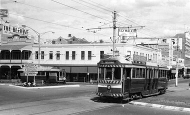 Ballarat Tramway Museum
Photograph - Black & White Photograph/s, George Bishop, Dec. 1971
Black and white photographs of Bendigo No. 23 and 19 at Charing Cross 12/1971. No. 23 has destination of Eaglehawk. The Beehive and Ezywalkin buildings in the background. No. 19 in the distance. Both trams have SEC Electric Cooking Roof Advertisements. Photos by George Bishop. .On the back of the photo in ink "SEC trams No. 19 and 23 (Bendigo System) at Charing Cross. / G. Bishop photo."tramways, trams, bendigo, charing cross, pall mall, tram 19, tram 23 -
 Kew Historical Society Inc
Photograph - Regrading the Camberwell Railway Line near Burke Road, E.J. Dower, 1915
One of a series of photographs, taken by Edgar James Dower in the second decade of the twentieth century. Born and raised in Olinda, his family later moved to Surrey Hills. He worked as an adult as a clerk in the city office of the Metropolitan Gas Company, and in his role as a 'collector', he was able to photograph scenes including the construction of tramlines, railways and associated buildings in Kew, Hawthorn, Camberwell and Surrey Hills. Later he established a real estate agency with his brother - the E.J. Dower Real Estate Agency, Dandenong Office.The image is an historically significant record of the development of transport infrastructure which was used to connect Victorians in the first two decades of the twentieth century. This development resulted from increases in population and the consequent extension of Melbourne's suburbs. The photographs, both individually and collectively, richly detail the labour of workers and the tools and machinery used to create and extend Melbourne's public transport network in the years preceding and during World War 1.Digital copy of an original mounted photograph depicting workers regrading the Camberwell Railway line following the demolition of the original Camberwell Railway Station. The level crossing gates at Burke Road can be seen in the distance. Named buildings include The Assembly Hall at right.Verso: "1915 / Regrading Camberwell Railway Line / Note Railway Gates on Burke Road / Taken by E.J. Dower"theme -- connecting victorians by transport and communications, theme - camberwell railway station, theme - travelling by train -
 Bendigo Historical Society Inc.
Photograph - PALL MALL, BENDIGO, 1926 - 28
BHS CollectionPall Mall Bendigo. black and white photograph. View of Pall Mall from top of building at Charing Cross, showing Queen Victoria statue, RSL Hall, Post Office, School of Mines in distance, Shamrock Hotel at right. Envelope also in folder.Fred Smithplace, land, pall mall, bendigo -
 Lakes Entrance Historical Society
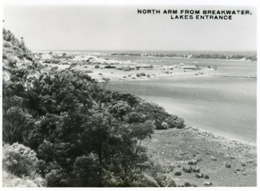
Postcard - North Arm Lakes Entrance, 1945c
One other copy same sizeBlack and white small format postcard of the entry to the North Arm, taken from Jemmys Point. It shows a steep cliffside above the calm waters, township of Lakes Entrance and Cunninghame Arm, and sand hummocks of southern shore in distance. Lakes Entrance VictoriaNorth Arm from Breakwater - Lakes Entrancetownship, waterways, topography -
 Lakes Entrance Historical Society
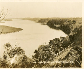
Postcard - Reeves Channel, Valentine Series, 1930c
Black and white small format postcard of Reeves Channel Gippsland Lakes, taken from Jemmys Point. It shows a glimpse of the Princes Highway, the steep shoreline of the mainland opposite Rigby Island with Fraser Island and Flannagan Island in distance. Lakes Entrance VictoriaKalimna Cove Lakes Entranceislands, waterways, topography -
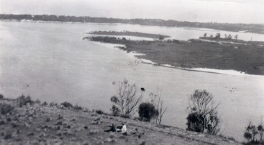 Lakes Entrance Historical Society
Photograph - Snake Island, 1930c
Black and white photograph, showing eastern end of Rigby Island, Snake Island, at Lakes Entrance, Victoria. Reeves Channel below foreground hill, Hopetoun Channel between dunes and islands with fish pens in distance. Two people sitting on hill in foreground.islands, waterways, topography, room display