Showing 15697 items
matching docuents-maps-france
-
 Ringwood and District Historical Society
Map, Plan of the Parish of Warrandyte County of Evelyn - 1841
Blueprint copy of Survey Map W27 detailing original Selectors' names and property locations between Yarra Yarra River (Warrandyte) and Mullum Mullum Creek (Ringwood). List of Parish map references including property bearings, distances in Links, and markings on trees. Pound Bend area of Warrandyte marked as Reserve For Aborigines. Descriptive remarks include areas marked "scrubby, flat, sandy soil". Several other references faded and illegible.(Map) by T.H. Nutt Feb 3 1841. -
 Warrnambool and District Historical Society Inc.
Postcard - Les Grenades, 1914-1918
This is number 22 of 27 items in the Daisy Vickers collection of World War One memorabilia. These items were sent or given to Daisy Ogier (nee Vickers) during World War One by Corporal Arthur Anderson who enlisted from Warrnambool in 1915 at the age of 21. He served in Egypt and France and returned to Australia in 1919. Daisy Ogier (1907-1987) was a student and then a teacher at Warrnambool Technical School with her early teaching years there from 1925 to 1936 and in 1949. She became the head mistress from 1950 to 1963 and in 1968. She officially retired in 1976. Daisy Vickers was one of the best loved and dedicated teachers that the school ever had. She married the Reverend Fred Ogier and continued her association with the school after her husband's death. This card is interesting because of its association with World War One and with two local people: Daisy Vickers and Arthur Anderson. This is a coloured postcard with a sketch of three children dressed in military outfits. The child dressed as a nurse is giving a piece of fruit to a child dressed as a wounded soldier. On the back it has space for correspondence and an address.Les Grenadesdaisy vickers, warrnambool, world war one post card, postcard ww1 -
 Warrnambool and District Historical Society Inc.
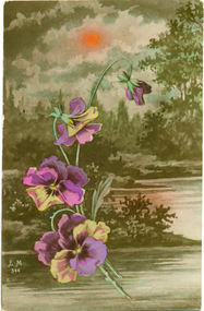
Postcard - Pansies, 1914-1918
This is number 19 of 27 items in the Daisy Vickers collection of World War One memorabilia. These items were sent or given to Daisy Ogier (nee Vickers) during World War One by Corporal Arthur Anderson who enlisted from Warrnambool in 1915 at the age of 21. He served in Egypt and France and returned to Australia in 1919. Daisy Ogier (1907-1987) was a student and then a teacher at Warrnambool Technical School with her early teaching years there from 1925 to 1936 and in 1949. She became the head mistress from 1950 to 1963 and in 1968. She officially retired in 1976. Daisy Vickers was one of the best loved and dedicated teachers that the school ever had. She married the Reverend Fred Ogier and continued her association with the school after her husband's death.This card is interesting because of its association with World War One and two local people Daisy Vickers ans Arthur AndersonThis postcard features pansies and an idyllic sylvan background. On the back it has space for correspondence and an address. There are initials and lettering on the front.E.M. 344 Fabrication Francaise daisy ogier nee vickers, arthur anderson, warrnambool technical school, world war one postcard -
 Warrnambool and District Historical Society Inc.
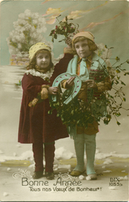
Postcard - Bonne Annee, 1914-1918
This is number 21 of 27 items in the Daisy Vickers collection of World War One memorabilia. These items were sent or given to Daisy Ogier (nee Vickers) during World War One by Corporal Arthur Anderson who enlisted from Warrnambool in 1915 at the age of 21. He served in Egypt and France and returned to Australia in 1919. Daisy Ogier (1907-1987) was a student and then a teacher at Warrnambool Technical School with her early teaching years there from 1925 to 1936 and in 1949. She became the head mistress in 1950 to 1963 and in 1968. Daisy Vickers was one of the best loved and dedicated teachers the school has ever had. She married the Reverend Fred Ogier and continued her association with the school after her husband's death. This card is interesting because of its association with World War One and two local people Daisy Vickers and Arthur AndersonThis postcard features two children standing together holding a horseshoe and flowers. In the background are more flowers. One child is wearing a deep red coloured dress with a lace collar and a hat The other child is wearing a hat, a scarf and leggings.There is black printing on the front. On the back is a hand written letter. Bonne Annee Tous nos Voeux de Bonheur DIX 105.5/3 Belgium August 13th. Dear Daisy, It is a long time since I had a letter from you so I thought I would give you a reminder to write one. Its some time now since I had a letter from Home . They don't come too often now as the Germans sink the mail boats . I am sending a handkerchief along with this card I hope you like it Arthur daisy vickers, warrnambool technical school, world war one postcard -
 Warrnambool and District Historical Society Inc.
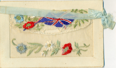
Postcard - World war one embroidered postcard, 1914-1918
This is Item 27 of 27 items in the Daisy Vickers collection of World War One memorabilia. These items were sent or given to Daisy Ogier (nee Vickers) during World War One by Corporal Arthur Anderson who enlisted from Warrnambool in 1915 at the age of 21. He served in Egypt and France and returned to Australia in 1919. Daisy Ogier (1907-1987) was a student and then a teacher at Warrnambool Technical School with her early teaching years there from 1925 to 1936 and in 1949. She became the head mistress from 1950 to 1963 and in 1968. She officially retired in 1976. Daisy Vickers was one of the best loved and dedicated teachers that the school ever had. She married the Reverend Fred Ogier and continued her association with the school after her husband's deathThis card is interesting because of its association with World War One and two local people Daisy Vickers and Arthur AndereonThis card features embroidered poppies and a Union Flag as part of the decoration. There is a narrow blue ribbon with a bow which has become detached. The back has lines for correspondence and a space for an address . Fabrication francaisedaisy vickers, arthur anderson, warrnambool technical school, world war 1 postcard -
 Bendigo Military Museum
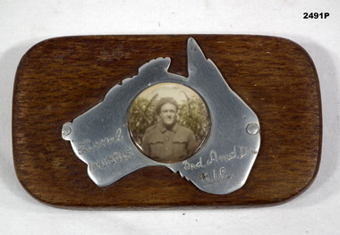
Memorabilia - PHOTOGRAPH WW2, Post WW2
The soldier is Lionel Clarence Younghusband, initial enlistment No N199216, transferred to AIF No NX115868 age 22 years on 7.9.1942, date of death listed as 14.7.1943 while serving in 3rd ARMD DIV.Black & white photograph mounted on polished map of Australia mounted on timber rectangular stand. Photograph of a soldier in uniform.Hand inscribed on map - “Lionel NX115868 / 3rd Amd Div / AIF”photography-photographs, military history - souvenirs -
 Melbourne Legacy
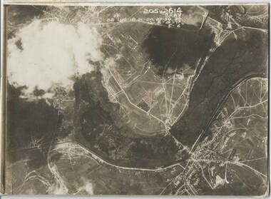
Photograph - Photo, Aerial view of the Somme
An aerial photo of the Somme in France during World War One. There are coordinates or numbers in some areas. Also labelled is Bray. Was with 11 other photos of World War One that had been mounted on board for display at Legacy House at some stage. When they were taken off display they were put in the archive cabinets. The founding legatees all served in World War One so these photos would have been of significant places for them. (see 01888 to 01899)Photos from World War One that would have been significant to the founding legatees.Sepia photo of the Somme battlefield in France during World War One.world war one, france, somme -
 Montmorency/Eltham RSL Sub Branch
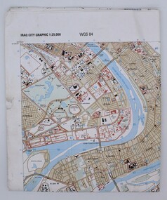
Map, Baghdad
Prepared and published by the National Imagery and Mapping Agency Copyright 2003 by the United States GovernmentPaper, coloured The map is of Baghdad Iraq city Graphic 1:25,000. WGS 84 Edition 11- NIMA Series K941 Sheet 4 Map information as of 2001map -
 Beechworth Cemetery Trust
Map - Beechworth Cemetery reproduction of original map -Secretary copy, Beechworth Cemetery
Reproduction map displaying all grave sites in Beechworth Public Cemetery. Rotunda, fountain, nursery, memorial wall, pioneer sectionmap displays the plan of grave sitesLaminated Photocopy of original cemetery map with additional information hand-written on the map. All graves at the cemetery set out in denominational sections with hand-written information on additional graves added to sections in Roman Catholic A & C, Church of England A-F, Presbyterian A-C, Methodist/Uniting B and Wesleyan A. Multidenominational hand-written note on Jews section with Trust Minutes 4.7.'83 written next to this addition. Additions hand-drawn of fountain, memorial wall, nursery and pioneer cemetery.rotunda, fountain, nursery, memorial wall, pioneer section, graves, chinese section, un-numbered grave sites, cemetery -
Beechworth Cemetery Trust
Map - Beechworth Cemetery reproduction of original map, Beechworth Cemetery Reproduction - Treasurer copy
Reproduction map displaying all grave sites in Beechworth Public Cemetery. Rotunda, fountain, nursery, memorial wall, pioneer sectionmap displays the plan of grave sitesLaminated Photocopy of original cemetery map with additional information hand-written on the map. All graves at the cemetery set out in denominational sections with hand-written information on additional graves added to sections in Roman Catholic A & C, Church of England A-F, Presbyterian A-C, Methodist/Uniting B and Wesleyan A. Multidenominational hand-written note on Jews section with Trust Minutes 4.7.'83 written next to this addition. Additions hand-drawn of fountain, memorial wall, nursery and pioneer cemetery.rotunda, fountain, nursery, memorial wall, pioneer section, graves, chinese section, un-numbered grave sites, cemetery -
Beechworth Cemetery Trust
Map - Beechworth Cemetery reproduction of original map - On site in Rotunda, Beechworth Cemetery
Reproduction map displaying all grave sites in Beechworth Public Cemetery. Rotunda, fountain, nursery, memorial wall, pioneer sectionmap displays the plan of grave sitesLaminated Photocopy of original cemetery map with additional information hand-written on the map. All graves at the cemetery set out in denominational sections with hand-written information on additional graves added to sections in Roman Catholic A & C, Church of England A-F, Presbyterian A-C, Methodist/Uniting B and Wesleyan A. Multidenominational hand-written note on Jews section with Trust Minutes 4.7.'83 written next to this addition. Additions hand-drawn of fountain, memorial wall, nursery and pioneer cemetery.rotunda, fountain, nursery, memorial wall, pioneer section, graves, chinese section, un-numbered grave sites, cemetery -
 Lara RSL Sub Branch
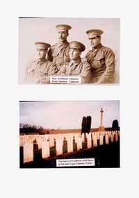
Photos, H Gibbons, Unknown
Photos of H Gibbons and grave site in Flat Iron Copse Cemetery France2 photos mounted on A4 paperH Gibbons The Grave of H Gibbons Amid those at Flat Iron Cemetery Franceh gibbons flay iron copse france world war 1 -
 Bendigo Military Museum
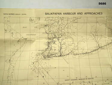
Map - MAP, DUTCH BORNEO
... Maps ...Map identified height of land in area and depth of ocean on approached to Balikpapan Harbour. Identified piers, streets and defences and potentially used for landing or combat in the area. MAP PRODUCED BY 2/1 AUST ARMY TOPO SQN CO. Large Yellow paper map with scale of 1:36,000 of Dutch Borneo Balikpapan Harbour and it's approaches. Map folded into 8.balikpapan harbour, maps -
4th/19th Prince of Wales's Light Horse Regiment Unit History Room
Medal, Air Crew Europe Star, abt 1945
The Air Crew Europe Star was awarded for operational flying from United Kingdom bases over Europe between 3 September 1939 and 5 June 1944. A person must first be entitled to the 1939-45 Star before qualifying for the Air Crew Europe Star. The Medal The Air Crew Europe Star is a six–pointed star of yellow copper zinc alloy. The obverse has a central design of the Royal and Imperial cypher, surmounted by a crown. The cypher is surrounded by a circlet containing the words ‘The Air Crew Europe Star'. Stars issued to Australian personnel have recipient names engraved on the plain reverse. The Ribbon The Air Crew Europe Star ribbon is light blue with yellow and black outer stripes. The colours represent the continuous service of the Air Forces by night and day. Clasps Two clasps were issued for the Air Crew Europe Star: Atlantic France and Germany Regulations only allow one clasp to be worn with the Star. When the ribbon is worn alone a silver rosette ribbon emblem is worn to denote the award of a clasp.Miniature with clasps: France and Germany & Atlanticmedal, air crew europe -
 Lara RSL Sub Branch
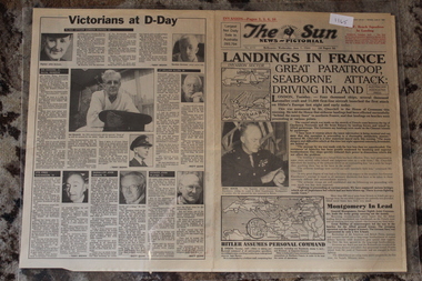
Newspaper - Herald Sun 50th Anniv. Re Print of a Newspaper dated 6/6/1994 Of D-Day 7/6/1944
Herald Sun 50th Anniv. Newspaper dated 6/6/1994 Of D-Day 7/6/1944Newspaper - D-Day Invasion 7/6/1944Herald Sun 50th Anniv. Newspaper dated 6/6/1994 Of D-Day 7/6/1944Landings In France - Hitler Assumes Personal Command - Map The Normandy Invasion D-Day 6/6/1944landings in france - hitler assumes personal command - map the normandy invasion d-day 6/6/1944 -
 Bendigo Military Museum
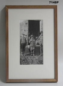
Photograph - PHOTOGRAPH, FRAMED WW1, Wayne Eels, C.2008/2009
The Grinton Collection. 38th Bn Soldiers with French children, one is dressed in an Australian uniform. Refer Cat Number 1280 for Jack Grintons service details.Photograph framed. Photograph - black and white photograph on paper depicting two children and one soldier standing outside a building window, with a further six soldiers grouped inside the open window. Frame - timber, light varnish finish, Perspex front, cardboard backing."Group 2: Burden of War". "L. Australian soldiers and French children."framed accessories, camera on the somme, ww1, 38th bn, grinton -
![Map, [Coornmill land area available for leasing for grazing, Parish of Coornmill]. Circa 1904](/media/collectors/5e461d8021ea67224c82f2a1/items/677cde147f2053f3e5d277c3/item-media/677cdeea7f2053f3e5d27bb4/item-fit-380x285.jpg) Bacchus Marsh & District Historical Society
Bacchus Marsh & District Historical SocietyMap, [Coornmill land area available for leasing for grazing, Parish of Coornmill]. Circa 1904
This map shows an area of land north of Bacchus Marsh in the Larderderg State Park area known as the Parish of Coornmill.The map indicates an area of land which was to be made available by public tender for grazing leaseholders. The plan to do this was discussed in the Bacchus Marsh Express newspaper on the 16 July, 1904, page 2, column 7. The area reserved for grazing leases is identified by red lines on the map. The Express described the area available for grazing was 12,000 acres.A single page paper map showing an area of land in the Parish of Corrnmill to be made available for grazing leases. A photo lithographed Lands Department Map. No scale indicated. The map is pasted into a bound volume containing 76 maps or plans in total. High resolution digital image stored on BMDHS computer network. coornmill parish maps, lerderderg state park maps, agriculture bacchus marsh area -
 Marysville & District Historical Society
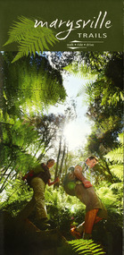
Map (Item) - Walking map, Department of Sustainability and Environment, marysville TRAILS, 07-2011
A map showing all the walking trails in and around Marysville and the district. This map was produced by the Department of Sustainability and Environment in July 2011.A map showing all the walking trails in and around Marysville and the district.ISBN 978-1-74287-122-6 (print)marysville, victoria, australia, marysville trails, department of sustainability and environment, parks victoria, steavenson falls trail, beauty spot trail, gilberts gully trail, tree fern gully trail, michaeldene trail, wilks creek trail, keppel lookout trail, lady talbot drive, taggerty cascades, the beeches, keppel falls, phantom falls, cathedral range state park, cambarville, lake mountain trails, cumberland falls, mystic mountains tourism -
Stawell Historical Society Inc
Map, Shire of Stawell, Shire of Stawell Interim development Order, C 1930
Planning MapColoured Map of Stawell Shire showing Zoning AreasGuttering Haskings & Davey Pty Ltd Division of Urban and Environmental Planninglocal development -
 Marysville & District Historical Society
Map (Item) - Tourist Map, Tourists Resorts' Committee, Tourist's Map of Healesville Marysville and Warburton Districts, 13.10.1925
A tourist map for Healesville, Marysville and Warburton that was produced by the Tourists Resorts' Committee. This map was produced in 1925.A tourist map for Healesville, Marysville and Warburton that was produced by the Tourists Resorts' Committee.Photo Lithographed at the Department of Lands and Survey, Melbourne by W.J. Butson./ 13.10.25healesville, marysville, warburton, victoria, tourists resorts' committee, ben cairn, mount donna buang, the black's spur, the acheron valley, narbethong, launching place, tourist information, tourism, map, tourist map -
 Peterborough History Group
Document - Maps, tourist information
Council boundaries, past tourist information, past mapsHistoric town information and mapsPhotocopies, copies of maps, newspaper clippingpeterborough history, peterborough 3270 -
Federation University Historical Collection
Map - Plan, Ballarat Deep Leads and Mines, 1992, 1992
This is Bulletin No. 62: Deep Lead Gold Deposits in Victoria. Map No.6 Ballarat Sheet 1 of 2 The map shows geology, topography and information on mines in the following areas: one large map of the Ballarat area with five enlargements for: Sago Hill District; Scarsdale District; Pitfield Plains District; Berringa Gold Field and Rokewood District. Ballarat Mines and Deep Leads Report No.94 (Finlay and Douglas,1992) provides a summary of the Geological Survey of Victoria mines database, references and geology for most of the mines on this map. Geology Compilation: simplified from earlier Departmental mapping with minor field checking by E.N.M. Plier-Malone. Very large rectangular sheet of paper with seven coloured maps of various sizes and a small green rectangle on the bottom rhs with a map of Victoria superimposed over a poppet head. this rectangle includes information of the other maps shown. The background for these maps is white. Also includes tables of names of mine companies, name of shafts and gold production.gold mines of australia, gold mines of victoria, gold mines- ballarat and district, gold mines pitfield plains district, gold mines scarsdale district, gold mines berringa gold field, gold mines rokewood district, gold mines sago hill district, map - gold mines, map - gold mines in victoria, ballarat, pitfield, scarsdale, berringa, rokewood, sago hill, deep lead gold deposits in victoria, geological survey - gold deposits in victoria, mining, gold deposits in victoria, gold mines in victoria, rokewook, pitfield plains -
 Bendigo Historical Society Inc.
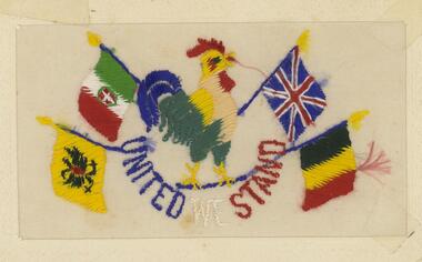
Postcard - BLANCHE SLY POSTCARD COLLECTION, 1900 - 1920
Postcard Album of Blanche Sly. Postcards stored in Folder 81 (49 postcards). 1403.1 - 1403.28 Grey linen look cover with picture of a small sailing boat pasted centre front pf cover. Partly torn sticker on lower LH corner. Blanche Victoria SLY Born: 11 Oct 1890, daughter of William and Hannah Sly Address: 1913; Loddon Vale Address: 1980; 100 Barnard Street Bendigo Died: Bendigo 12 June 1982, buried Bendigo G3 William Sly: Born: 1856 at Smythesdale, Victoria Married in Victoria in 1887; Hannah Theilman Died: Bendigo 1937, buried Bendigo G1 Hannah Sly Nee Theilman Born: 1866 Married in Victoria in 1887; William Sly Died: Bendigo 1948, buried Bendigo G3 See additional Research .Postcard Album of Blanche Sly containing 49 postcards. See 1403 Colourful embroidery on silk of a French cockerel surrounded by flags of Austria, Italy, Britain and Belgium. In a cardboard frame "United We Stand" embroidered in blue, white and red .Addressee - Miss B Sly, Loddon Vale, Victoria Sender - Tommy Dated France 16/4/1916postcard, collector, blanche sly -
 Melbourne Tram Museum
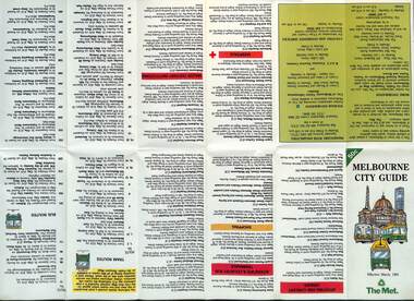
Map, The Met, "Melbourne City Guide", March 1991
... maps ...Map issued by The Met, March 1991 based on a Melway map of the Central city area providing details of tram, bus and trains, attractions, major institutions, tourism information, and dining out areas or streets. Demonstrates a map produced by The Met to assist Melbourne visitors.Map - 14 fold printed on gloss paper.trams, tramways, the met, maps, melbourne, cbd -
 Victorian Aboriginal Corporation for Languages
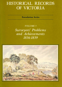
Book, Michael Cannon, Historical records of Victoria : foundation series : volume 5 : surveyors? problems and achievements 1836-1839, 1988
Reproductions of various transactions and reports dealing with the surveying history of Port Phillip, including letters, maps, illustrations, tables, and a detailed history of the surveying of Victoria.maps, b&w illustrations, b&w photographs, tablesvictorian history, port phillip, robert hoddle, monee monee creek, geelong, barwon river, werribee river -
 Robin Boyd Foundation
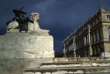
Slide, Robin Boyd, 1950
Penleigh Boyd, Robin and Patricia Boyd's son, writes “Prior to 1950 Robin, like most other amateur or hobby photographers, took black and white printed photographs. The oldest slides date from 1950 when Robin and Patricia travelled to Europe on Robin’s Robert Haddon Travelling Scholarship.” In 1948 Robin Boyd was awarded ‘joint first place’ in the Robert Haddon competition for his design of Mildura art gallery. The scholarship helped fund their first overseas trip. Robin and Patricia were passengers on the Greek ship “Cyrenia” departing in May 1950, passing through the Suez Canal and landing in Genoa five weeks later. For six months, they travelled extensively throughout Europe (predominantly driving themselves) - France, Italy, United Kingdom, Sweden, Denmark, Germany, Austria, Switzerland and Spain.Colour slide in a mount. Western facade, Versaille, FranceVersailles / W.Facade (All Handwritten)haddon travelling scholarship, haddon, robin boyd, slide -
 Robin Boyd Foundation
Slide, Robin Boyd, 1950
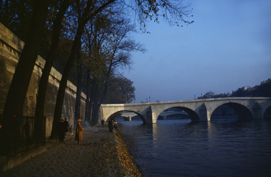
Penleigh Boyd, Robin and Patricia Boyd's son, writes “Prior to 1950 Robin, like most other amateur or hobby photographers, took black and white printed photographs. The oldest slides date from 1950 when Robin and Patricia travelled to Europe on Robin’s Robert Haddon Travelling Scholarship.” In 1948 Robin Boyd was awarded ‘joint first place’ in the Robert Haddon competition for his design of Mildura art gallery. The scholarship helped fund their first overseas trip. Robin and Patricia were passengers on the Greek ship “Cyrenia” departing in May 1950, passing through the Suez Canal and landing in Genoa five weeks later. For six months, they travelled extensively throughout Europe (predominantly driving themselves) - France, Italy, United Kingdom, Sweden, Denmark, Germany, Austria, Switzerland and Spain.Colour slide in a mount. Pont Royal, Paris, FranceParis / Point Royal (All Handwritten)haddon travelling scholarship, haddon, robin boyd, slide -
 Bendigo Military Museum
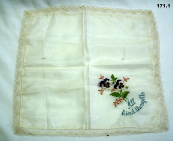
Souvenir - SILK SOUVENIRS, 1914-18
Embroidered handkerchiefs - Souvenirs from 1914-1918.Embroidered handkerchiefs - souvenirs from 1914 - 1918. .1) Silk handkerchief edged with lace & embroidered with two white 7 purple pansies and the words "All kind thoughts" in one corner. .2) Silk handkerchief with gold ribbon edging, embroidered with six flags and yellow & mauve pansy plus the words "Souvenir de France".1) Embroidered with "All kind thoughts" .2) Embroidered with "Souvenir de France"handcrafts-embroidery, souvenirs, silk -
 Eltham District Historical Society Inc
Book, Melway Publishing, Melway Greater Melbourne street directory : including Geelong, Phillip Island, Healesville, Bellarine & Mornington Peninsulas, 2002
... maps ...Edition 29. Coloured detailed maps accessed by a street or location index. Cover: 20 additional pages of new maps, extended coverage of Bellarine Peninsula, further coverage of Werribee South, Public Transport Information, latest official suburb boundaries, CBD "hook turn" intersections map, over 1200 new streets, 1 atlas (24, 886 p.) : col. maps ; ISSN 03113957streets, roads, melbourne, maps, melway