Showing 2524 items matching "melbourne water."
-
 Victoria Police Museum
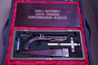
Vampire Slaying Kit, Early 19th Century
Item was seized by Victoria Police during a drugs raid at Pascoe Vale South in 2004.19th Century Vampire Slaying Kit in a wooden box. Contains a pistol, silver pistol balls with crosses on them, wooden stake and holy water bottle.vampires, supernatural, weapons -
 Warrnambool and District Historical Society Inc.
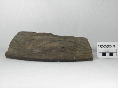
Souvenir - Shipwreck item, Falls of Halladale, 1886
The Falls of Halladale was a four-masted iron-hulled barque built for the long-distance bulk carrier trade. In dense fog on the night of 14 November 1908 she was sailed onto rocks off Peterborough due to a navigational error. The 29 crew abandoned ship safely and reached shore by boat. The ship was left foundering with sails unfurled. For weeks afterwards large crowds gathered to view the ship as she gradually broke up and sank in the shallow water. Shortly after the accident the ship's master, Captain Thomson, faced a Court of Marine Enquiry in Melbourne. He was found guilty of a gross act of misconduct, having carelessly navigated the ship, neglected to take proper soundings and failing to place the ship on a port tack before it became too late to avoid shipwreck. Thomson's punishment included a small fine and six months suspension of his Master's Certificate of Competency. The hull lies on its starboard side about 300 metres off-shore in 3-15 metres of water. The original cargo included 56,763 roofing slates and coils of barbed wire. 22,000 slates were salvaged in the 1980s and used as roofing at Flagstaff Hill Maritime Village, Warrnambool.This item has historical significance as it came from one of the known shipwrecks along the South West coast of Victoria. There are a number of photographs of the wreck as it founded on the rock and hence is an image with which many people are familiar. Curved piece of timber with flat base from the wreck of the ship Falls of Halladale. Inside is recessed with slight ledge near back. A chunk of timber is missing on the top. The face has swirled carvings with leaf and seed design and base curved to the edge.Hand painted in red paint on inside bottom edge 'PETERBOROUGH'. Hand painted in white paint on bottom 'FALLS OF HALLADALE/WRECKED/PETERBOROUGH/VIC/NOV. 1908'melbourne, shipwrecks, flagstaff hill maritime village, warrnambool, falls of halladale, barques, peterborough victoria, roofing slates, captain thomson, thomson, court of marine enquiry -
 Warrnambool and District Historical Society Inc.
Work on paper - Letter, Henry Watts, Letter written 1859
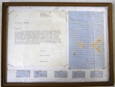
Henry Watts (1828_1889) Died at Melbourne, 16th December, 1889. He was a good microscopist. His botanical studies were chiefly devoted to algae, both fresh-water and marine, and while living for many years at Warrnambool he was a contributor of algae to Harvey, who figured Wrangelia wattsii, Harv., and Crouania wattsii, Harv., in his “Phycologia Australica " He was the author of "On the Fresh-water Algae of Victoria " (Trans. Roy. Soc. Vict., 1861-4, 67) ; .also a paper "On Fossil Polyzoa" (ib.. 82); "A Trip to Mt. Macedon in Search of Fresh-water Algae" (Wing's S. S. Record, iii., 252); "On a Species of fresh-water Algae from Victoria" (Vict. Nat., i., 21); "Some Recent Additions to our Knowledge of Microscopic Natural History" (ib., iii., I33) (includes lists of fresh-water algae and Desmidieae ), First librarian (1881-2), also a vice-president of the Field Naturalists' Club of Victoria. He is further commemorated by Acacia wattsiana. F. v. M. www.anbg.gov.au/biography/watts-henry.html . Henry Watts worked as a bootmaker in Timor and Liebig streets Warrnambool in the 1860’s but it was as an amateur scientist that Watts gained public notice.For an exhibiton in Melbourne in 1861 Henry Watts prepared a collection of over 100 different species of seaweed from the Warrnambool district. It is recorded in the Examiner in 1863 that he had been elected as an honorary member of the Bristol Microscopical Society of England He was a member of the Warrnambool Horticultural society and in 1865 he opted to become a flower distiller.At the 1866 MelbourneExhibition, Henry Watts exhibited 44 bottles of his perfumes. He had a keen interest in microscopes and microscopic organisms.He spent many hours combing the caves and examining the guano of local bats. This letter is written to Professor Quekett advising him that he has sent a collection of packets of samples of diatomaceae asking him to examine and name the same.. Professor Quekett was a famous microscopist of the Victorian era with the Quekett microscopist club one of the oldest in the world dedicated to the use of the microscope and its discoveries. Henry Watts was one of Warrnambool’s first botanists and marine scientists. He also established a flower distilling and perfume manufacturing business in Warrnambool. In 1861 he sent a collection of over 100 species of seaweed to the Melbourne Exhibition.Framed, handwritten letter, ink on blue paper. Transcript of letter is typed black on white paper. Five small numbered pieces of paper containing specimens of diatomaceae collected from marine and fresh water areas around Warrnambool.Names Henry Watts, Professor Quekett. Handwritten along the bottom of the frame, “The above was bought at a London Auction for $12-10-00 by Miss Eddey a Melbourne Book shop Proprietress and recently presented to the W.F.N. Club.: warrnambool, henry watts, watts henry, botanist,microscope, microscopic, quekett, john thomas quekett -
 Eltham District Historical Society Inc
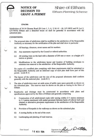
Document, Notice of Decision to Grant a Permit; Ref: E94/306 - Subdivision of 30-34 Diosma Road; 16 November 1994, 16/11/1994
This permit was eventually overturned following community objection and the land was donated by Yarra Valley Water for use as a community reserve.The Stokes Orchard Estate collection is typical of housing developments of the late 1970s and 1980s. It was one of the earliest estates in Eltham following the nearby Woodridge Estate development.A4 document consisting of ten pagesAs notedstokes place, eltham, stokes orchard, stokes orchard estate, streets, houses, peter and carla vermey, diosma road, letter of objection, melbourne metropolitan board of works, planning application, reservoir, shire of eltham -
 Eltham District Historical Society Inc
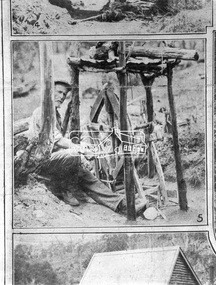
Negative - Photograph, The Leader, An Old-Timer and his Old-Time Blower, 2 Nov. 1929
Queenstown (St. Andrews) District. A gold miner with his home made dry blower device used for extracting gold particles from dry soil with out the use of water. In 1929, St Andrews was known as Queenstown. Originally published in The Leader, Nov. 2nd, 1929, with the title "Relics of the Old Mining days in the Queenstown District," a series of eight numbered photographs. 'The Leader'; a weekly journal of news, politics, agriculture, literature, science and sport.This photo forms part of a collection of photographs gathered by the Shire of Eltham for their centenary project book,"Pioneers and Painters: 100 years of the Shire of Eltham" by Alan Marshall (1971). The collection of over 500 images is held in partnership between Eltham District Historical Society and Yarra Plenty Regional Library (Eltham Library) and is now formally known as 'The Shire of Eltham Pioneers Photograph Collection.' It is significant in being the first community sourced collection representing the places and people of the Shire's first one hundred years.Digital image 4 x 5 inch B&W Neg Print 11 x 24.5 cmsepp, shire of eltham pioneers photograph collection, queenstown, gold mining, gold miner, st. andrews, old timer -
 Eltham District Historical Society Inc
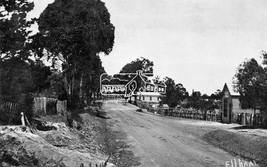
Negative - Photograph, Tom Prior, Main Road near Eltham Railway Station, c.1910
View looking south along Main Road, Eltham from near present day Luck Street. On the immediate right is a fence with the words “Hot Water” painted on it followed by William J Capewell’s butcher shop, then the slaughter yard and saleyards with the entrance access to the railway station. Contained within the saleyards facing the street, a small shelter with the name H.H. Clark upon it. Horace Harold Clark was the son of Eltham State School’s first Head Teacher, David George Clark. As well as being a farmer, he was an Estate Agent and conducted auction sales, presumably from this shelter. The large weatherboard building on the corner (opposite present-day Arthur Street) with signs for Summer Drinks and Hot Water painted on the side is Luther and Ada Haley’s General Store and Bakery, built 1902. This was the first building in what is now Eltham’s present shopping town centre. Haley previously ran the General Store and Bakery on the corner of Main Road and York Street until his lease expired and the premises were bought by Mrs Sarah Burgoyne in 1902. The store later was known as Staff's Store. In the distance approximately mid-way between the Butcher shop and the Bakery are the tops of what appears to be two cypress trees, which could well be the trees in front of the Shillinglaw Cottage facing Main Road. On the eastern (left) side of Main Street is Haley’s Paddock, which was used on occasions for community picnics. Capable of holding 10,000 people, with ample shade and hilly surroundings it was an ideal place for any community gathering such as the State Schools’ Picnic in 1904. Picture dated as c.1910 based on similar picture published in the Weekly Times, Feb. 1912. Kerb and channelling added 1923. Cross Ref: 610 (looking north), 611 (later stage), 613. Same as 705 (though in better condition)This photo forms part of a collection of photographs gathered by the Shire of Eltham for their centenary project book,"Pioneers and Painters: 100 years of the Shire of Eltham" by Alan Marshall (1971). The collection of over 500 images is held in partnership between Eltham District Historical Society and Yarra Plenty Regional Library (Eltham Library) and is now formally known as the 'The Shire of Eltham Pioneers Photograph Collection.' It is significant in being the first community sourced collection representing the places and people of the Shire's first one hundred years.Digital image 4 x 5 inch B&W Neg 120 format B&W negative (spare)shire of eltham pioneers photograph collection, eltham, main road, butcher, eltham railway station, railway station, w.j. capewell, baker, eltham town centre, general store, luther haley, reynolds prior collection, shops, haley's paddock, hot water, m.m. clark, sign, summer drinks, eltham sale yards, eltham slaughter yard, staffs general store -
 Eltham District Historical Society Inc
Photograph, Eltham - Floods in 1934
To the left of picture is the Main Road Bridge over the Diamond Creek in Eltham South when the Diamond Creek was in flood. The Yarra also was in flood. In early December 1934 the "Greatest flood in the history of the Yarra" occured, according to The Argus newspaper. Bridges and houses were swept away with hundreds of people left homeless across the state. The historic 1934 flood of the Diamond Creek and Yarra River set the criteria for future planning with respect to flood water rise.This photo forms part of a collection of photographs gathered by the Shire of Eltham for their centenary project book, "Pioneers and Painters: 100 years of the Shire of Eltham" by Alan Marshall (1971). The collection of over 500 images is held in partnership between Eltham District Historical Society and Yarra Plenty Regional Library (Eltham Library) and is now formally known as 'The Shire of Eltham Pioneers Photograph Collection.' It is significant in being the first community sourced collection representing the places and people of the Shire's first one hundred years.Digital image 4 x 5 inch B&W Negsepp, shire of eltham pioneers photograph collection, eltham, diamond creek (river), 1934 flood, diamond creek, floods, main road bridge -
 Eltham District Historical Society Inc
Photograph, Floodwaters, Diamond Creek, Eltham, 1934
The Diamond Creek in flood near the Main Road bridge at Eltham, Victoria. The Yarra also was in flood. In early December 1934 the "Greatest flood in the history of the Yarra" occured, according to The Argus newspaper. Bridges and houses were swept away with hundreds of people left homeless across the state. The historic 1934 flood of the Diamond Creek and Yarra River set the criteria for future planning with respect to flood water rise.This photo forms part of a collection of photographs gathered by the Shire of Eltham for their centenary project book, "Pioneers and Painters: 100 years of the Shire of Eltham" by Alan Marshall (1971). The collection of over 500 images is held in partnership between Eltham District Historical Society and Yarra Plenty Regional Library (Eltham Library) and is now formally known as 'The Shire of Eltham Pioneers Photograph Collection.' It is significant in being the first community sourced collection representing the places and people of the Shire's first one hundred years.Digital image 4 x 5 inch B&W Neg (2 frames on one neg) 9 x 15.5 cm B&W printflooding, eltham, shire of eltham pioneers photograph collection, sepp, diamond creek (river), floods, 1934 flood, diamond creek -
 Eltham District Historical Society Inc
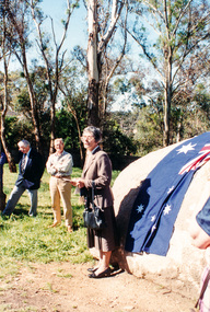
Photograph, Mary Owen, granddaughter of Walter Withers, unveiling the commemorative plaque on Walter Withers Rock at the corner of Bible and Arthur Streets, Eltham, 13 Oct 1990, 13/10/1990
[from EDHS Newsletter No. 75, November 1990:] WALTER WITHERS PLAQUE At long last we have unveiled our plaque in the Walter Withers Reserve. The function was attended by a number of members and friends of the Society and descendants of the Withers family. Following the unveiling, the group proceeded to the Eltham Shire Office for afternoon tea and a small exhibition of Withers' paintings arranged by Andrew Mackenzie. The unveiling was performed by Mary Owen, a grand-daughter of Walter Withers. Her speech provided an interesting personal perspective on Withers and is repeated in full here: I feel somewhat overwhelmed by the responsibility of paying tribute to the man you have all come to honour today. I have the feeling that most of you probably know more about him and his work than I do. Walter Withers died nearly seven years before I was born and so I never knew him. Sadly, although other members of his family inherited some of his talent, I was not among them and I know very little about art. This is doubly hard to bear because my husband had some ability to draw and my second daughter also has some talent in this direction. My children are all artistic - mostly in the field of music inherited partly from their father - a Welshman who sang like a Welshman - and partly from my grandmother, Fanny Withers who, I believe was no mean pianist. However all this talent gave me a miss and for many years I felt a complete ignoramus in the fields of the arts. It was not until I was nearly fifty years old that I walked into a gallery in Brisbane and, as I wandered around the room, suddenly one picture leapt at me and I knew instantly that it had been painted by my grandfather. I had never seen the picture before and it gave me quite a shock to find that I had recognized the style of painting. I realized then that I had absorbed more than I realized simply by living with pictures and with people who painted them and talked about their painting and the painting of others. When I was a child I sometimes spent school holidays with my Aunt Margery Withers and her husband, Richard McCann. Aunt Marge painted me several times but I'm afraid I was a restless subject and used to sit reading a book and look up grudgingly when she wanted to paint my eyes. During the September holidays my aunt and uncle were busy preparing paintings far the annual exhibition of the Melbourne Twenty Painters, to which they both belonged. I remember how important I used to feel when they took me along to the Athenaeum Gallery on the Friday night before the opening to help hang their pictures. There were many artists there but the two I remember are perhaps surprisingly both women: Miss Bale and Miss Tweddle. I remember how cold it used to be up in that gallery at night. They used to heat water on a gas ring to make tea and Aunt Marge used to bring sandwiches and fruit for our evening meal. Everyone seemed to be poor in those days and no-one dreamed of going out for a meal. It was a case of make-do - even to cutting down frames to fit pictures or cutting pictures to fit the frames. They had to use the same frames from year to year if the pictures didn't sell. The opening was an exciting event for me. I felt I was privileged to meet important people - people who knew a lot more than I - and Uncle Dick would get quite merry after a couple of the tiny sweet sherries which were always distributed. I realise now that quite a lot of "art talk" rubbed off on me during my visits to the Athenaeum and during my stays with my aunt and uncle. I suspect that much of our most useful learning comes this way and those of us who have had the privilege of associating with artists, writers, philosophers and other thinkers have a richness in our lives of which we may be unaware. Walter Withers was a prolific painter and, although he painted for love of it, I suspect that the need to provide for his family drove him, like Mozart, to greater efforts than he might otherwise have achieved. Reading old letters and articles about the Heidelberg artists, I have come to realize something of the constant strain placed on many of them - particularly Withers and McCubbin - by poverty and the need to make ends meet. Withers was ever conscious of the need to provide for his wife and his five children and there are touching letters to his wife, regretting that he was not able to earn more for them. In addition to his painting, he worked hard at teaching and illustrating and, as he grew older, the strain began to tell and his health deteriorated. He seems never to have had a very strong constitution and suffered from rheumatism, which must have made painting quite painful at times. His eldest daughter, Gladys, was eventually confined to a wheelchair with rheumatoid arthritis and I have a tendency to arthritis myself, so I am particularly aware of what this could have meant to him. Recently I found a short letter written by my mother to her mother, Fanny Withers on the anniversary of her father's birthday in 1919, in which she said: "Poor old Dad, I often think now what a lot he must have suffered. His life was too hard and too strenuous for him. He had too many chick-a-biddies, I think. He wasn't equal to so much town life and train journeys with so many delicacies as he had. Since I have been ill, I have realised what he must have felt like.” He certainly drove himself to produce. He travelled all over Victoria by train, buggy, bicycle and on foot and for a time he travelled from Eltham to Melbourne every day by train, although later he lived in Melbourne during the week and only returned to Eltham for the weekends. My mother died seven years after her father's death, when my twin sisters were 10 days old and I was 16 months. So I never knew my mother or my grandfather. But my two aunts, Gladys and Margery, sometimes took me to stay with Gan Withers at Southernwood in Bolton Street . No cars in those days and it seemed a very long hot and dusty walk from the Station. Three memories remain with me of Southernwood. One is the well at the back which I found quite terrifying; the second is Gan killing a snake - even more terrifying. She was a formidable woman, my grandmother and a great ally and support to her husband. I think she was the business end of the partnership. The third memory of Southernwood is my grandfather's studio – down what seemed like a toy staircase inside the room. This and the big walk-in fireplace stayed in my mind from the age of about six until I saw them again about forty years later when the house was being used as a Sunday School. I just wish that money could be found to purchase this old house for the City of Eltham so that a permanent museum could be established in memory of a man who did so much to put Eltham on the map of art history. Recently I have become interested in family history and spent some time in England, Ireland and Wales looking for traces of my ancestors. I realized then how important it is to have records of people who have contributed to our society. We forget so soon and it is amazing how often, within two generations, names, dates and many details are forgotten. We are fortunate that so many of Walter Withers' works have been bought by galleries and that people like Andrew Mackenzie have taken the trouble to search out people who knew him and to write about him and his work. And I am very grateful to the Historical Society of Eltham for recognizing the importance of having a permanent tribute in Eltham to the contribution made by Walter Withers, who loved Eltham so much and who has assured this lovely district a place in the annals of history. I am indebted to Kathleen Mangan; the daughter of another famous Australian painter , Fred McCubbin, - featured in The Age this morning (thanks again to Andrew Mackenzie) for the most apt tribute to Walter Withers. Kathleen is not well and she rang me a couple of days ago, regretting that she could not be present today “to pay tribute” as she said, “to Walter Withers for I always think Walter Withers is the spirit of Eltham.” Thank you, Kathleen. And now I have much pleasure in unveiling the plaque commissioned by the Eltham Historical Society from Bob McLellan of Charmac Industries to commemorate the life and work of Walter Withers, the spirit of Eltham. Mary Owen, 13 October 1990.Three colour photographswalter withers rock, walter withers reserve, mary owen -
 Eltham District Historical Society Inc
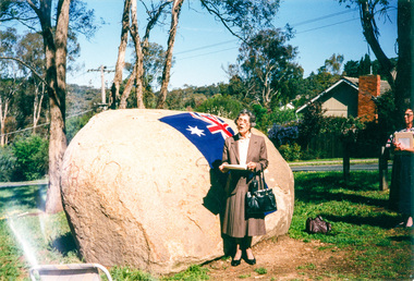
Photograph, Mary Owen, granddaughter of Walter Withers, unveiling the commemorative plaque on Walter Withers Rock at the corner of Bible and Arthur Streets, Eltham, 13 Oct 1990, 13/10/1990
[from EDHS Newsletter No. 75, November 1990:] WALTER WITHERS PLAQUE At long last we have unveiled our plaque in the Walter Withers Reserve. The function was attended by a number of members and friends of the Society and descendants of the Withers family. Following the unveiling, the group proceeded to the Eltham Shire Office for afternoon tea and a small exhibition of Withers' paintings arranged by Andrew Mackenzie. The unveiling was performed by Mary Owen, a grand-daughter of Walter Withers. Her speech provided an interesting personal perspective on Withers and is repeated in full here: I feel somewhat overwhelmed by the responsibility of paying tribute to the man you have all come to honour today. I have the feeling that most of you probably know more about him and his work than I do. Walter Withers died nearly seven years before I was born and so I never knew him. Sadly, although other members of his family inherited some of his talent, I was not among them and I know very little about art. This is doubly hard to bear because my husband had some ability to draw and my second daughter also has some talent in this direction. My children are all artistic - mostly in the field of music inherited partly from their father - a Welshman who sang like a Welshman - and partly from my grandmother, Fanny Withers who, I believe was no mean pianist. However all this talent gave me a miss and for many years I felt a complete ignoramus in the fields of the arts. It was not until I was nearly fifty years old that I walked into a gallery in Brisbane and, as I wandered around the room, suddenly one picture leapt at me and I knew instantly that it had been painted by my grandfather. I had never seen the picture before and it gave me quite a shock to find that I had recognized the style of painting. I realized then that I had absorbed more than I realized simply by living with pictures and with people who painted them and talked about their painting and the painting of others. When I was a child I sometimes spent school holidays with my Aunt Margery Withers and her husband, Richard McCann. Aunt Marge painted me several times but I'm afraid I was a restless subject and used to sit reading a book and look up grudgingly when she wanted to paint my eyes. During the September holidays my aunt and uncle were busy preparing paintings far the annual exhibition of the Melbourne Twenty Painters, to which they both belonged. I remember how important I used to feel when they took me along to the Athenaeum Gallery on the Friday night before the opening to help hang their pictures. There were many artists there but the two I remember are perhaps surprisingly both women: Miss Bale and Miss Tweddle. I remember how cold it used to be up in that gallery at night. They used to heat water on a gas ring to make tea and Aunt Marge used to bring sandwiches and fruit for our evening meal. Everyone seemed to be poor in those days and no-one dreamed of going out for a meal. It was a case of make-do - even to cutting down frames to fit pictures or cutting pictures to fit the frames. They had to use the same frames from year to year if the pictures didn't sell. The opening was an exciting event for me. I felt I was privileged to meet important people - people who knew a lot more than I - and Uncle Dick would get quite merry after a couple of the tiny sweet sherries which were always distributed. I realise now that quite a lot of "art talk" rubbed off on me during my visits to the Athenaeum and during my stays with my aunt and uncle. I suspect that much of our most useful learning comes this way and those of us who have had the privilege of associating with artists, writers, philosophers and other thinkers have a richness in our lives of which we may be unaware. Walter Withers was a prolific painter and, although he painted for love of it, I suspect that the need to provide for his family drove him, like Mozart, to greater efforts than he might otherwise have achieved. Reading old letters and articles about the Heidelberg artists, I have come to realize something of the constant strain placed on many of them - particularly Withers and McCubbin - by poverty and the need to make ends meet. Withers was ever conscious of the need to provide for his wife and his five children and there are touching letters to his wife, regretting that he was not able to earn more for them. In addition to his painting, he worked hard at teaching and illustrating and, as he grew older, the strain began to tell and his health deteriorated. He seems never to have had a very strong constitution and suffered from rheumatism, which must have made painting quite painful at times. His eldest daughter, Gladys, was eventually confined to a wheelchair with rheumatoid arthritis and I have a tendency to arthritis myself, so I am particularly aware of what this could have meant to him. Recently I found a short letter written by my mother to her mother, Fanny Withers on the anniversary of her father's birthday in 1919, in which she said: "Poor old Dad, I often think now what a lot he must have suffered. His life was too hard and too strenuous for him. He had too many chick-a-biddies, I think. He wasn't equal to so much town life and train journeys with so many delicacies as he had. Since I have been ill, I have realised what he must have felt like.” He certainly drove himself to produce. He travelled all over Victoria by train, buggy, bicycle and on foot and for a time he travelled from Eltham to Melbourne every day by train, although later he lived in Melbourne during the week and only returned to Eltham for the weekends. My mother died seven years after her father's death, when my twin sisters were 10 days old and I was 16 months. So I never knew my mother or my grandfather. But my two aunts, Gladys and Margery, sometimes took me to stay with Gan Withers at Southernwood in Bolton Street . No cars in those days and it seemed a very long hot and dusty walk from the Station. Three memories remain with me of Southernwood. One is the well at the back which I found quite terrifying; the second is Gan killing a snake - even more terrifying. She was a formidable woman, my grandmother and a great ally and support to her husband. I think she was the business end of the partnership. The third memory of Southernwood is my grandfather's studio – down what seemed like a toy staircase inside the room. This and the big walk-in fireplace stayed in my mind from the age of about six until I saw them again about forty years later when the house was being used as a Sunday School. I just wish that money could be found to purchase this old house for the City of Eltham so that a permanent museum could be established in memory of a man who did so much to put Eltham on the map of art history. Recently I have become interested in family history and spent some time in England, Ireland and Wales looking for traces of my ancestors. I realized then how important it is to have records of people who have contributed to our society. We forget so soon and it is amazing how often, within two generations, names, dates and many details are forgotten. We are fortunate that so many of Walter Withers' works have been bought by galleries and that people like Andrew Mackenzie have taken the trouble to search out people who knew him and to write about him and his work. And I am very grateful to the Historical Society of Eltham for recognizing the importance of having a permanent tribute in Eltham to the contribution made by Walter Withers, who loved Eltham so much and who has assured this lovely district a place in the annals of history. I am indebted to Kathleen Mangan; the daughter of another famous Australian painter , Fred McCubbin, - featured in The Age this morning (thanks again to Andrew Mackenzie) for the most apt tribute to Walter Withers. Kathleen is not well and she rang me a couple of days ago, regretting that she could not be present today “to pay tribute” as she said, “to Walter Withers for I always think Walter Withers is the spirit of Eltham.” Thank you, Kathleen. And now I have much pleasure in unveiling the plaque commissioned by the Eltham Historical Society from Bob McLellan of Charmac Industries to commemorate the life and work of Walter Withers, the spirit of Eltham. Mary Owen, 13 October 1990.Two colour photographswalter withers rock, walter withers reserve, mary owen -
 Eltham District Historical Society Inc
Photograph, Murchison Gap, Autumn Excursion, Hume and Hovell's 1824 expedition, 26 May 1996, 26/05/1996
[article by Bettina Woodburn in EDHS Newsletter No. 109, July 1996:] ON THE TRAIL OF HUME AND HOVELL - REPORT ON THE AUTUMN EXCURSION - On a green and fresh morning (Sunday 26th May 1996) the Cobb and Co coach (driven by the most obliging Peter Tampion) set off in a north easterly direction from Eltham to connect with Hume and Hovell's route on their 1824 explorations of central Victoria. The Society would follow a series of monuments erected for the 1924 centenary of the expedition from King Parrot Creek (Tuesday 7th December 1824), through Strath Creek, over Sunday Creek (Sunday 12th December 1824) at Broadford, Tullamarine, St Albans, Deer Park, through Werribee, skirting east of the You Yangs to Lara and Avalon Beach. Because their distance-measuring wheel had broken and a one degree mistake was made in calculations, the two leaders of the original group of six convict-companions arrived at Corio Bay, instead of the expected Western Port, discovered earlier by Flinders. From below Mt. Disappointment (Hume and Hovell's difficulties in "scrambling over brush and rock", "leeches in forest, as well as no water", "cutting grass 4-5 ft. high", dreadful scrub", "devil flies") we took an easier route, saw the Strath Creek memorial in ground fog and a wonderful "field of dreams", the Hume-Hovell privately owned cricket ground with its white picket boundary fence. Now, after a steep climb, in sunshine under gums we stretched and viewed magnificent rolling hills and fog-filled valleys - not "smoke from Aborigines' bush fires". After morning tea at Broadford we followed the Sunday Creek valley beside the Hume Freeway, passed the Wallan Wallan Rest Area (more appropriately Hume and Hovell Rest Area) to tum right at Beveridge. In Gellibrand Hill Park, near the headwaters of the Moonee Ponds Creek, we experienced the landscape the first European settlers saw - huge river red gums and rolling pastures. The gardens and sheltered courtyard of the 1840s, timber, brought from .....[?] prefabricated Woodlands Homestead, provided a pleasant lunch stop. We enjoyed a private tour, panoramic views over Melbourne and surroundings and the excitement of arriving and departing aircraft. Our next river crossing was at Werribee, "in a vast treeless plain", then we drove on by-ways no coach had previously travelled, to find "an immense sheet of water" salty Corio Bay, off-course to the west. In late afternoon of a super, calm, late autumn day we headed homewards. Back at Eltham we were rather surprised to find that we had travelled a total of 347 km. Thanks again to Russell Yeoman for his research and organization. What a wonderful day! Three colour photographsactivities, murchison gap, murchison valley -
 Eltham District Historical Society Inc
Photograph, Hume and Hovell Monument, Broadford, Autumn Excursion, Hume and Hovell's 1824 expedition, 26 May 1996, 26/05/1996
[article by Bettina Woodburn in EDHS Newsletter No. 109, July 1996:] ON THE TRAIL OF HUME AND HOVELL - REPORT ON THE AUTUMN EXCURSION - On a green and fresh morning (Sunday 26th May 1996) the Cobb and Co coach (driven by the most obliging Peter Tampion) set off in a north easterly direction from Eltham to connect with Hume and Hovell's route on their 1824 explorations of central Victoria. The Society would follow a series of monuments erected for the 1924 centenary of the expedition from King Parrot Creek (Tuesday 7th December 1824), through Strath Creek, over Sunday Creek (Sunday 12th December 1824) at Broadford, Tullamarine, St Albans, Deer Park, through Werribee, skirting east of the You Yangs to Lara and Avalon Beach. Because their distance-measuring wheel had broken and a one degree mistake was made in calculations, the two leaders of the original group of six convict-companions arrived at Corio Bay, instead of the expected Western Port, discovered earlier by Flinders. From below Mt. Disappointment (Hume and Hovell's difficulties in "scrambling over brush and rock", "leeches in forest, as well as no water", "cutting grass 4-5 ft. high", dreadful scrub", "devil flies") we took an easier route, saw the Strath Creek memorial in ground fog and a wonderful "field of dreams", the Hume-Hovell privately owned cricket ground with its white picket boundary fence. Now, after a steep climb, in sunshine under gums we stretched and viewed magnificent rolling hills and fog-filled valleys - not "smoke from Aborigines' bush fires". After morning tea at Broadford we followed the Sunday Creek valley beside the Hume Freeway, passed the Wallan Wallan Rest Area (more appropriately Hume and Hovell Rest Area) to tum right at Beveridge. In Gellibrand Hill Park, near the headwaters of the Moonee Ponds Creek, we experienced the landscape the first European settlers saw - huge river red gums and rolling pastures. The gardens and sheltered courtyard of the 1840s, timber, brought from .....[?] prefabricated Woodlands Homestead, provided a pleasant lunch stop. We enjoyed a private tour, panoramic views over Melbourne and surroundings and the excitement of arriving and departing aircraft. Our next river crossing was at Werribee, "in a vast treeless plain", then we drove on by-ways no coach had previously travelled, to find "an immense sheet of water" salty Corio Bay, off-course to the west. In late afternoon of a super, calm, late autumn day we headed homewards. Back at Eltham we were rather surprised to find that we had travelled a total of 347 km. Thanks again to Russell Yeoman for his research and organization. What a wonderful day! Colour photographactivities, broadford, hume and hovell, monument -
 Eltham District Historical Society Inc
Photograph, Hume and Hovell Monument, Autumn Excursion, Hume and Hovell's 1824 expedition, 26 May 1996, 26/05/1996
[article by Bettina Woodburn in EDHS Newsletter No. 109, July 1996:] ON THE TRAIL OF HUME AND HOVELL - REPORT ON THE AUTUMN EXCURSION - On a green and fresh morning (Sunday 26th May 1996) the Cobb and Co coach (driven by the most obliging Peter Tampion) set off in a north easterly direction from Eltham to connect with Hume and Hovell's route on their 1824 explorations of central Victoria. The Society would follow a series of monuments erected for the 1924 centenary of the expedition from King Parrot Creek (Tuesday 7th December 1824), through Strath Creek, over Sunday Creek (Sunday 12th December 1824) at Broadford, Tullamarine, St Albans, Deer Park, through Werribee, skirting east of the You Yangs to Lara and Avalon Beach. Because their distance-measuring wheel had broken and a one degree mistake was made in calculations, the two leaders of the original group of six convict-companions arrived at Corio Bay, instead of the expected Western Port, discovered earlier by Flinders. From below Mt. Disappointment (Hume and Hovell's difficulties in "scrambling over brush and rock", "leeches in forest, as well as no water", "cutting grass 4-5 ft. high", dreadful scrub", "devil flies") we took an easier route, saw the Strath Creek memorial in ground fog and a wonderful "field of dreams", the Hume-Hovell privately owned cricket ground with its white picket boundary fence. Now, after a steep climb, in sunshine under gums we stretched and viewed magnificent rolling hills and fog-filled valleys - not "smoke from Aborigines' bush fires". After morning tea at Broadford we followed the Sunday Creek valley beside the Hume Freeway, passed the Wallan Wallan Rest Area (more appropriately Hume and Hovell Rest Area) to tum right at Beveridge. In Gellibrand Hill Park, near the headwaters of the Moonee Ponds Creek, we experienced the landscape the first European settlers saw - huge river red gums and rolling pastures. The gardens and sheltered courtyard of the 1840s, timber, brought from .....[?] prefabricated Woodlands Homestead, provided a pleasant lunch stop. We enjoyed a private tour, panoramic views over Melbourne and surroundings and the excitement of arriving and departing aircraft. Our next river crossing was at Werribee, "in a vast treeless plain", then we drove on by-ways no coach had previously travelled, to find "an immense sheet of water" salty Corio Bay, off-course to the west. In late afternoon of a super, calm, late autumn day we headed homewards. Back at Eltham we were rather surprised to find that we had travelled a total of 347 km. Thanks again to Russell Yeoman for his research and organization. What a wonderful day! Two colour photographsactivities, hume and hovell, monument -
 Eltham District Historical Society Inc
Book, Pharmacy Dispensing Register, L.J. Thompson, Chemist, Eltham, 21 June 1928-25 October 1929, 1928-1929
Contains a daily record of medicines issued by name/code and to whom but not residence. Last nine pages contain an index of namesHardcover book approx 28 x 12 cm containing 190 pages; front cover loose and damaged (poor condition), rear cover missing; first page torn and first/last few pages suffering water damage with subsequent fading to ink writing though still legible. remaining pages in good condition. Contains a daily record of medicines issued by name/code and to whom but not residence. Last nine pages contain an index of names and pharmacy codes commencing at last page with D; page containing A-C missing.maroondah aqueduct, research (vic.) -
 Eltham District Historical Society Inc
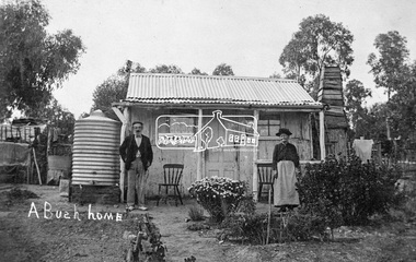
Photograph, Tom Prior, A Bush Home - Research, Vic, c.1895
A slab hut situated in Research, Victoria. An elderly man and woman stand in front of their small bark slab home with bark chimney. It has a tin roof and tin water tank to the side. A small garden is situated at the front. Reproduced on pp 38-39 of 'Pioneers & Painters: One Hundred years of Eltham and it's Shire" (1971) Article in "Australian Family Tree Connections" February 2000 by B. J. Parkinson claims that the people in this photo are "Jonas and Christina Jane (Gregg) PRIOR in front of their home at Ferny Hill, near Eltham, Victoria, 1877". Photocopy of photo also attached to 14 online family trees for the Prior family on Ancestry.com without the words "A Bush Home". References found to Prior in historical newspapers and the property "Ferny Hill". Jonas was a convict from Kent, England. He arrived in Hobart in 1821 aged 19 years. He married Christina Gregg in Hobart about 1834 and had 11 children. They came to Victoria about 1846. He died at Ferny Hill, near Research, Eltham in 1878 aged 74 years and was buried at Melbourne General Cemetery. His occupation was gardener.This photo forms part of a collection of photographs gathered by the Shire of Eltham for their centenary project book,"Pioneers and Painters: 100 years of the Shire of Eltham" by Alan Marshall (1971). The collection of over 500 images is held in partnership between Eltham District Historical Society and Yarra Plenty Regional Library (Eltham Library) and is now formally known as the 'The Shire of Eltham Pioneers Photograph Collection.' It is significant in being the first community sourced collection representing the places and people of the Shire's first one hundred years.Digital image 4 x 5 inch B&W Neg Print 20 x 25 cmshire of eltham pioneers photograph collection, research (vic.), ferny hill, jonas prior, christina prior, hut, prior, convict, pioneers and painters -
 Ringwood and District Historical Society
Photographs/documents, Harris Family memorabilia - photos of house and land, wedding etc. Will of Richard Francis Harris. Death Cert of James Augustine Harris. 1960s-1980s, 1960-1980s
Collection of the Harris family memorabilia given to Richard Carter by Judy O'Neill. Wedding groups may be James Harris' wedding. The collection of 22 photos include boring for water in the 1968 drought. The will of Richard Francis Harris gives a share to James Augustine Harris. James Augustine Harris' vaccination certificate was sent to Mr. M.W. Harris, Queen Street Bendigo. James lived in Dorset Rd Boronia prior to his death.Collection of 22 photos - 9x9 - black and white - house and land; 4 wedding photos - un-named; 3 miscellaneous photos; Will of Richard Francis Harris; Vaccination certificate; Death certificate of James Augustine Harris with his funeral arrangements and tributes -
Ringwood and District Historical Society
Book, Borough of Ringwood Collector Water Rate Cash Book
Bound book "Borough of Ringwood Collector Water Rate Cash Book" -
Ringwood and District Historical Society
Book, Borough of Ringwood Ledger Water Account
Bound book "Borough of Ringwood Ledger Water Account" -
 Ringwood and District Historical Society
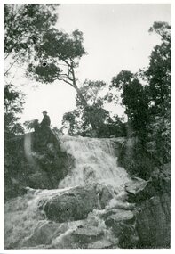
Photograph, Loughnan Lake overflow c.1930, c.1930
Loughnan Lake overflow c.1930. Strong flow of water over waterfall. Man & dog sitting at top of the waterfall. -
 Ringwood and District Historical Society
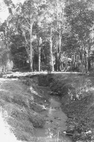
Photograph, View along Mullum Creek in the reserve at foot of New Street 1981
Written on back of photograph, "16/6/81. View along Mullum Creek in the reserve at foot of New Street. The water was clear" -
Ringwood and District Historical Society
Envelope, Packet: Ringwood Area Environment - Land Conservation Council, 150 years of Victoria's Rivers 1989. Heritage Inventory
Historic places, Land Conservation Council relating to past 150 years of Victoria's rivers, streams and water systems; Heritage inventory -
Ringwood and District Historical Society
Envelope, Packet: Objections - Correspondence (Ringwood) - Roads, Drains, Water, Rates etc. 1930s-1940s
Correspondence (mainly hand written) about objections to Roads; Correspondence (mainly hand written) about objections to Drains; Correspondence (mainly hand written) about objections to Wards; Correspondence (mainly hand written) about objections to Water; Correspondence (mainly hand written) about objections to Flooding; Correspondence (mainly hand written) about objections to Rates -
Ringwood and District Historical Society
Envelope, Packet: Water Conservation Booklet and Ringwood Clippings. Proposed Yarra Dam. 1964
... Road Ringwood North melbourne Water conservation booklet - 1968 ...Water conservation booklet - 1968; Newspaper cuttings 1964-1991 -
 Ringwood and District Historical Society
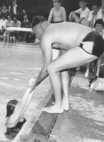
Photograph, Ringwood Baths, 1957. Harold Walklate demonstrating correct method of lifting patient out of water
Black and white photograph. (Photo taken by David Holmes, Blackburn)Written on back of photograph, "Ringwood Baths, 15/12/57. Harold Walklate demonstrating the method of lifting a patient out of the water. Patient Glenys Leaven of Mentone." -
 Ringwood and District Historical Society
Book, Water for Metropolis
... Road Ringwood North melbourne The Maroondah Water Supply System ...The Maroondah Water Supply System History 18 February 1891. -
Ringwood and District Historical Society
Book, Borough of Ringwood Water General Cash Book
Bound book "Borough of Ringwood Water General Cash Book" -
Ringwood and District Historical Society
Book, Borough of Ringwood Water Rates Cash Book
Bound book "Borough of Ringwood Water Rates Cash Book" -
 Australian Commando Association - Victoria
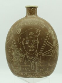
Equipment, Engraved Japanese water bottle
... . melbourne Engraved Japanese water bottle Equipment ... -
Australian Commando Association - Victoria
Equipment - Water bottle
... . melbourne Equipment Water bottle ... -
 Ringwood and District Historical Society
Letter, Property for sale - Ringwood Shop and Dwelling Estate, Ringwood, Victoria - circa 1925
ID 5225 note: Further information relating to allotments marked on the hand-drawn plan are included in ID 5224 - Ringwood Station Estate.Typewritten letter from A.V. Greenwood with hand drawn plan of Ringwood Shop and Dwelling Estate, detailed description of property for sale, and top and side elevation views of house. (7 pages)(Transcript of first page - to unknown recipient) Phone 988 Central, 331 Canty Greenwood Pty. Ltd. 5 Flinders Street Melbourne. Dear Sir, 1. Attached please find drawings of my house at Ringwood. 2. It is for sale at £4,865 or to let at £5 per week to an approved tenant. 3. I sold it to Mr. De Garis and vacated it, but it is now back on my hands. 4. I leased another place instead of living in my own. I may be able to cancel same; in the meantime, however, I propose to sell or let my own. The painters are now going through the place; re-varnishing, re-oiling and re-polishing so that in about five days it will look "spick and span". 5. The house was specially built under my own supervision. 6. It is very suitable for a high class Guest House, Doctor's residence, Hospital or Convalescent Home. If you know of anyone whom it might suit, please communicate with them. DESCRIPTION 7. It stands on 305 feet of land facing Greenwood Avenue. It is cement, roughcast and hardwood, well oiled, and is now being redone so that the house is as good as new; red tile roof; verandahs three sides; two sleep-outs; five bedrooms; large dining room; very large music room with nooks, upstairs lounge, study; sewing room; built-in wardrobes and cupboards throughout; handsome kitchen with handsome pantry cupboard with drawers and glass front; one bath room; one shower room; wash house with patent copper and laundry. Every modern convenience, hot water system (through copper pipes with large copper cylinder) electric lights everywhere, outside and in, Yan Yean water laid on everwhere throughout house and gardens. Floors throughout are the very best, close set, stained and polished; dainty lead light windows etc. 8. There is a big garage, with tiled roof and two rooms with all conveniences for a married couple. Property is well drained with a system of its own. The house stands upon the top of a hill close to Railway Station, say 500 feet from the Footbridge. 9. The garden has expansive shrubs; sheds; fernery; tennis court. 10. A handsome piece of furniture goes with the house; a combination pantry and storeroom for groceries, milk, bread etc., consisting of drawers, glass and wire doors, as mentioned above. 11. It is within easy distance of Melbourne as it is only two minutes from Ringwood Station, which is a frequent electric train service bringing it within 39 minutes of the City. It is thought better by some to go further out into the country atmosphere and walk a short distance at the end than to go by train 20 minutes then walk 15 to 20 minutes. 12. The price quoted of £4,865 is made up as follows - 305 feet of land @ £5 ... £1,515 Garage and dwelling ... £300 House hot water system, American cupboard ... £2,600 Water, fencing, sheds & drain ... £250 For the lot ... £4,865 Should you require copies of the enclosed drawings I shall be pleased to supply same. 13. Mr. J.B. McAlpin is the local agent, Phone Ring. 7 (after hours Ring. 44) or you may phone me Central 988. 14. The house is south of the line, facing Greenwood Avenue and immediately at the back of Ringwood House, which is also my property. Yours sincerely, A.V. Greenwood (illegible) ..... (Transcript of second page) RINGWOOD SHOP AND DWELLING ESTATE See these letters on plan attached (H.) Ringwood House and Shops on 100 by 150 feet of land fronting Bedford Road 100 feet @ £10 per foot - £1,000 House and shops - £2,400 ... £3,400 Ringwood House consists of Boarding House, (Phone 101) and two shops, mainly brick; 9 inch walls. Will carry another story. Has music room, dining room, entrance halls, 10 bedrooms, large verandahs, all conveniences, hot and cold water, and stands on what will become a most valuable business corner. (F.)(G.) Mr. Greenwood's house, garage and sheds, stands on 307 feet of land fronting Greenwood Avenue. See detailed description attached ... £4,865 (J.) Cottage on Block 81 in William Street ... £750 (K.) Cottage in Pitt Street ... £650 (Total) £9,665 ..... (Description of third page - Subdivision Plan) Drawn by Edyth Greenwood, phone 988 Central. Subdivision includes Station Street, Pitt Street, Bedford Road, Wantirna Road, James Street, William Street (later Kendall Street), Greenwood Avenue, Ellison Street, and Haig Street. Circles denote blocks for sale. Squares denote house properties for sale. Other features marked include location of businesses along Main Street (Maroondah Highway), cool store, railway station, shop and police station on Bedford Road, church on Station Street, site of schoolmaster's residence and State School, and location of proposed public baths